Browse Listings in Africa > Southern Africa > Southern Africa
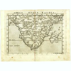
Africa nuova tavola.
Uncommon first edition of this early map of South Africa. Madagascar is called Isola de S. Lorenzo and is oddly shaped.The origin of the Nile conforms to the Ptolemaic co...
- $550 / ≈ €481
Date: Venice, Vincenzo Valgrisi, 1561
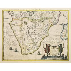
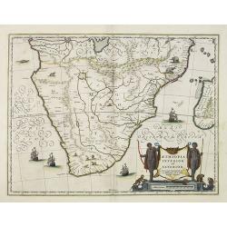
Aethiopia Inferior vel Exterior.
The standard map of South Africa throughout the 17th century. The lake out of which the 'Zambere' -the Zambesi- flows is probably based on reports of Lake Ngami, undiscov...
- $750 / ≈ €656
Date: Amsterdam, 1640
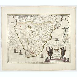
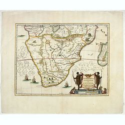
Aethiopia inferior, vel exterior.
The standard map of South Africa throughout the 17th century. The lake out of which the 'Zambere' -the Zambesi- flows is probably based on reports of Lake Ngami, undiscov...
- $1100 / ≈ €962
Date: Amsterdam, 1644
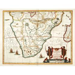
Aethiopia inferior, vel exterior.
The standard map of South Africa throughout the 17th century. The lake out of which the 'Zambere' -the Zambesi- flows is probably based on reports of Lake Ngami, undiscov...
Date: Amsterdam, 1645
Aethiopia inferior, vel exterior.
The standard map of South Africa throughout the 17th century. The lake out of which the 'Zambere' -the Zambesi- flows is probably based on reports of Lake Ngami, undiscov...
Date: Amsterdam, 1645
Aethiopia inferior, vel exterior.
The standard map of South Africa throughout the 17th century. The lake out of which the 'Zambere' -the Zambesi- flows is probably based on reports of Lake Ngami, undiscov...
- $800 / ≈ €699
Date: Amsterdam, ca. 1660

Cimbebas et Caffariae Littora a Catenbela ad Promontorium. . .
The coast of Angola, South-West Africa and South Africa up to Port Elizabeth. Classic sea chart of Dutch school with excellent baroque embellishment. North oriented to th...
Date: Amsterdam, 1675
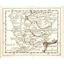
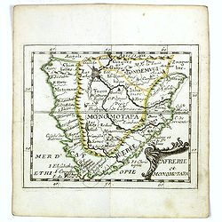
Cafrerie et Monomotapa.
Uncommon miniature map of South Africa, from Pierre Duval's "La Geographie Universeille" dated 1676. Following his Cartes de geographie in 1657, Pierre Duval pu...
Date: Paris, 1676
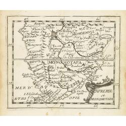
Cafrerie et Monomotapa.
Uncommon miniature map of South Africa from Pierre Duval's "La Geographie Universeille" dated 1676. Following his Cartes de géographie in 1657, Pierre Duval pub...
Date: Paris, 1676
Cafrerie et Monomotapa.
Uncommon miniature map of South Africa from Pierre Duval's "La Geographie Universeille" dated 1676. Following his Cartes de geographie in 1657, Pierre Duval pub...
- $175 / ≈ €153
Date: Paris, 1676
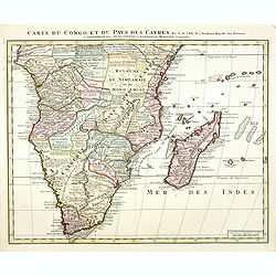
Carte du Congo et du Pays des Cafres.
Large map of the Southern part of Africa, including Madagascar. With the imprint "Chez l’Auteur sur le Quai de l’Horloge (imprint erased after Horloge) avec Privilèg...
Date: Paris, January 1708
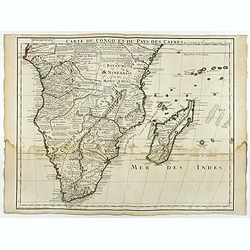
Carte du Congo et du Pays des Cafres. . .
Detailed copper-engraved map of southern Africa providing numerous particulars and comments concerning European trade, native kingdoms, and mineral wealth. Includes Madag...
Date: Amsterdam, c. 1730
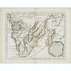
Partie meridionale de l'Afrique ou se trouvent le Congo. . .
Scarce map of south of Africa with Madagascar, prepared by Nolin and published by L.J. Mondhare for his Atlas Général a l'usage des colleges et maisons d'education.. Loui...
- $200 / ≈ €175
Date: Paris, 1783
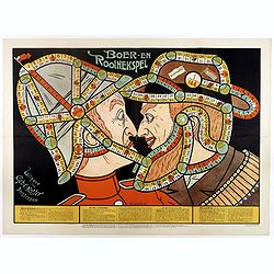
Boer-en Rooinekspel.
Design by E.G.Schlette. This is a board game similar to the famous "snakes and lessons". The game takes the players through various historical battles. Success ...
- $600 / ≈ €525
Date: Amsterdam, Koster, ca. 1890
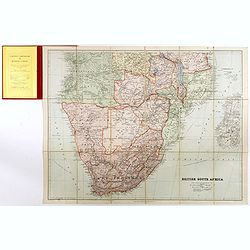
British South Africa.
With the signature of Alan Sillitoe (1928-2010), who was England’s best writer of proletarian fiction. From an early age, geography and maps were a very important part of...
- $450 / ≈ €393
Date: London, 1923
