Browse Listings in Africa > Southern Africa > Madagascar & other Islands
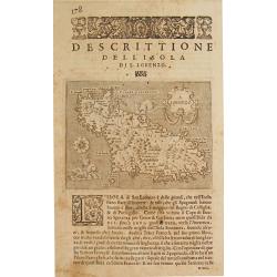
Map of Madagascar.
An old antique map of Madagascar by Tomaso Porcacchi (1530-85). L' Isole del Monde, 1572-1686. Maps engraved by Girolamo Porro. An early map of Madagascar, embellished wi...
Date: Italy, ca. 1580
![Plants found in the island of S. Laurenti [Madagascar].](/uploads/cache/41368-250x250.jpg)
Plants found in the island of S. Laurenti [Madagascar].
‘ A’ denotes a tree with only a few twigs on the top. From this tree, canoes and boats are made. ‘B’ is a bush that the Dutch frequently encountered and was calle...
- $80 / ≈ €70
Date: Frankfurt, 1598
![[Madagascar].](/uploads/cache/37962-250x250.jpg)
[Madagascar].
Two text engravings from "Premier livre de l'histoire de la navigation aux Indes Orientales, par les hollandois, et des choses a eux advenues . . . ", being the...
- $125 / ≈ €109
Date: Amsterdam, Cornille Nicolas, 1609
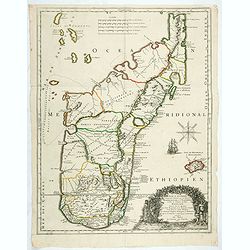
Isle D'Auphine, communement Nommée pae les Europeens Madagascar. . .
One of the most UpToDate maps of Madagascar, also showing the Comoros Islands in the North West and the Reunion Island in the South East.With decorative title cartouche r...
- $900 / ≈ €785
Date: Paris, 1667

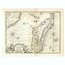
Isola di Madagascar o di S. Lorenzo Scoperta dà Portoghesi nell anno 1506. . .
Decorative and highly detailed map of Madagascar, including 2 decorative cartouches and other embellishments.The remarkable Vincenzo Coronelli (1650-1718), was a Francisc...
Date: Venice, 1690

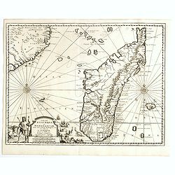
Insula S. Laurentii.
Miniature map of Madagascar, with four inset maps. From the French reissue of the account of early Dutch voyages first published in 1608 by Commelin. The French translati...
Date: Amsterdam, E. Roger, 1702
Ile de S. Laurens, ou Madagascar, située dans L'Ocean Ethiopien, sur les Côtes de L'Afrique.
Detailed map of Madagascar and Réunion. Published by Pieter van der Aa in "Galérie agréable du monde", completed in 1729. The Galerie was a sixty-six volume ...
Date: Leiden, 1729
Ile de S. Laurens, ou Madagascar, située dans L'Ocean Ethiopien, sur les Côtes de L'Afrique.
Detailed map of Madagascar and Réunion. Published by Pieter van der Aa in "Galérie agréable du monde", completed in 1729. The Galerie was a sixty-six volume ...
Date: Leiden, 1729
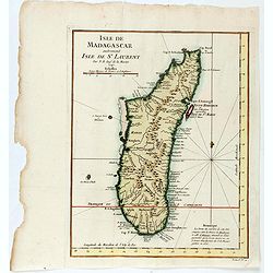
Isle de Magagascar . . .
Map of the island of Madagascar. Prepared by Jacques Nicolaas Bellin (1703-1772) who was one of the most important and proficient French cartographers of the mid-eighteen...
- $75 / ≈ €65
Date: Paris, 1750
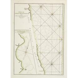
Côte de l'Isle de Madagascar depuis la Baye de Vohemare jusqu'à la pointe de l'Est. Plan du Port et de la Baye du Cap de l'Est.
French chart of the east coast of Madagascar.Latitude and longitude scales, compass rose and system of rhumb lines, soundings near coast and in bay areas.D' Après de Man...
- $100 / ≈ €87
Date: Paris, Brest, chez Demonville, 1775
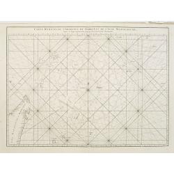
Carte réduite de l'Archipel du Nord-Est de l'Ile Madagascar.
French sea chart of an archipelago off the coast of Madagascar. The northeastern coast of Madagascar is included.Latitude and longitude scales, compass rose and system of...
- $100 / ≈ €87
Date: Paris, Brest, chez Demonville, 1775
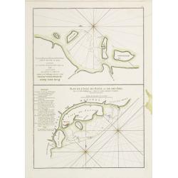
Plan des Isles Querimbo, Oybo, et Matemo / Plan de l'Ile de Patte et de son Port.
French sea chart of Isles Patte, Querimbo, Oybo, Matemo on East coast of Madagascar. Latitude and longitude scales, compass rose and system of rhumb lines, soundings near...
- $75 / ≈ €65
Date: Paris, Brest, chez Demonville, 1775
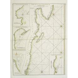
Carte Orientale de Madacascar Depuis la Rivière Ivondrou jusqu'à Mananzari.
Large sea sea chart of the southeast coastline of Madagascar and four inset maps of the harbors and anchorage of Tamatave, Foulpointe, Teintingue und Veninguebe. Inset ma...
- $125 / ≈ €109
Date: Paris, Brest, chez Demonville, 1775
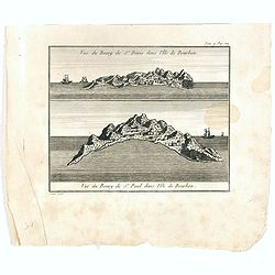
Vue du Bourg de St Denis dans l'Isle Bourbon. (together wit) Vue du Bourg de St.Paul dans l'Ile de Bourbon.
Two views from L'île de la Réunion on one plate. The upper part showing the town and harbour of St. Denis. From "Lettres Édifiantes et Curieuses. . Missionaires d...
- $45 / ≈ €39
Date: Lyon, J. Vernarel and Et. Cabin et C., 1780/1781
![[Map of Madagascar, Mauricius island and Réunion island, in Cyrillic ].](/uploads/cache/42567-250x250.jpg)
[Map of Madagascar, Mauricius island and Réunion island, in Cyrillic ].
A map of the south eastern coast of Africa and the island of Madagascar, comprehending 2 insets of the island of Bourbon (today Reunion) and Mauritius.The title appears i...
- $750 / ≈ €655
Date: Paris / St.Petersburg, ca. 1790
