Browse Listings
![[Drawing of a Tulip]](/uploads/cache/06597-250x250.jpg)
[Drawing of a Tulip]
Very detailed and well executed tulip drawing by an unknown artist belonging to the School of Anthony Claesz (1607/8-1649)This drawing was made for a 'Tulip book' painted...
- $1200 / ≈ €1034
Date: The Netherlands c.1700
![[Drawing of a Tulip]](/uploads/cache/06621-250x250.jpg)
[Drawing of a Tulip]
Very detailed and well-executed tulip drawing by an unknown artist attributed to the School of Anthony Claesz (1607/8-1649)This drawing was made for a 'Tulip book' painte...
- $1500 / ≈ €1292
Date: The Netherlands c.1700
![[Drawing of a Tulip]](/uploads/cache/06622-250x250.jpg)
[Drawing of a Tulip]
Very detailed and well executed tulip drawing by an unknown artist belonging to the School of Anthony Claesz (1607/8-1649)This drawing was made for a 'Tulip book' painted...
- $1500 / ≈ €1292
Date: The Netherlands c.1700
![Jean De Sacro Busto. [Johannes de Sacro Bosco]](/uploads/cache/39090-250x250.jpg)
Jean De Sacro Busto. [Johannes de Sacro Bosco]
Portrait of Johannes de Sacro Bosco c. 1195 – c. 1256), a scholar, monk and astronomer who was a teacher at the University of Paris. He wrote a short astronomy textbook...
- $150 / ≈ €129
Date: France, ca. 1700
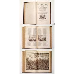
Alle De Wercken, soo Oude als Nieuwe van den Heer Jacob Cats, Ridder, oudt Raadtpensionaris Van Hollandt, &c. : Op nieus vermeerdert met des Autheurs Tachtig-jarig Leven, Huyshoudinge en Bedenckingen op Zorg-vliet.
A very good example of the collected works of the most celebrated Dutch author of the seventeenth century. Illustrated with over 400 engravings after van de Venne by Hond...
- $1900 / ≈ €1636
Date: Amsterdam, 1700
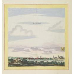
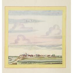
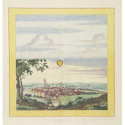
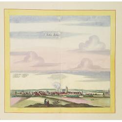
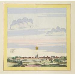
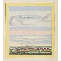
Statt Alten Rüppin.
Very decorative and rare panoramic town-view of Statt Alten Rüppin.The engraver and publisher of prints, Mrs. Anna Beek of the Hague, enlarged the print and mounted it o...
Date: The Hague, ca. 1700
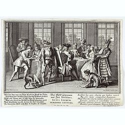
Lusus Lucrum Temporis Iactura.
Copper-plate engraving showing a group of fashionably dressed men and women playing cards. "Paulus Decker inv. et del.; Ioh. Christoph Steudner sculp.; Mart. Engelbr...
Date: Augsburg, 1700
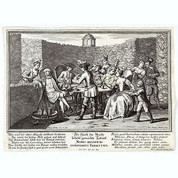
Moris Beneficio Comendatus Tabaci usus. Der durch die Mode beliebt gemachteTaback
Copper-plate engraving showing a group of fashionably dressed men and women smoking long-stemmed pipes around a table in front of a garden hedge. "Paulus Decker inv....
Date: Augsburg, 1700
![[Concert at time of Handel] Dulcissimum Melos Bona Fama.](/uploads/cache/47201-250x250.jpg)
[Concert at time of Handel] Dulcissimum Melos Bona Fama.
Copper-plate engraving of the rehearsal of a chamber cantata by Johann Christoph Steudner, after Paul Decker the elder, in the Handel-Haus, Halle. (Musikgeschichte in Bil...
Date: Augsburg, 1700
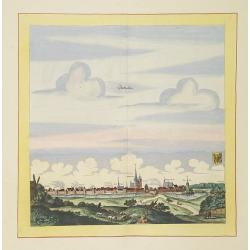
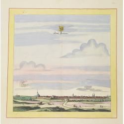
Stättlein Frohsa.
Very decorative and rare panoramic town view of Frohse a.d. Elbe, Bez. Magdeburg.The engraver and publisher of prints, Mrs. Anna Beek of the Hague, enlarged the print and...
Date: The Hague, ca. 1700
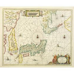
Nova et accurata Japoniae terrae Esonis, ac Insularum adjacentium.
The map is of interest in showing Korea as a curiously shaped island and in revising the shape of the three main Islands of Japan. A re-issue of Janssonius' map with the ...
Date: Amsterdam, 1700
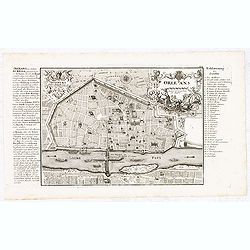
Orleans.
Nice scarce detailed town-plan of Orleans, from Bodenehr's "Atlas curieux" published in Augsburg.Incredibly detailed, shows the city of Orleans with many place ...
- $150 / ≈ €129
Date: Augsburg, ca. 1700
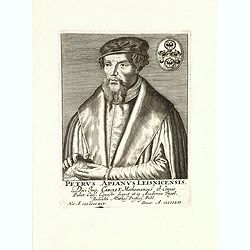
Petrus Apianus Leisnicensis.
Rare copper engraved portrait of Petrus Apianus (1495 – 1552) by Wolfgang Philipp Kilian. Peter Apian, was a German humanist, known for his works in mathematics, astron...
- $300 / ≈ €258
Date: Augsburg, ca.. 1700
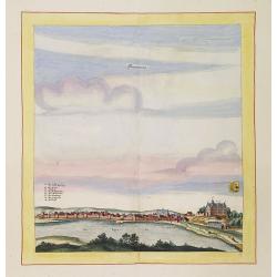
Laûn.
Very decorative and rare panoramic of Laun Louny a.d. Eger Böhmen.The engraver and publisher of prints, Mrs. Anna Beek of the Hague, enlarged the print and mounted it o...
Date: The Hague, ca. 1700
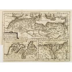
BARBARIE.
An uncommon and delightful map of Northern Africa extends from today's territory of Morocco as far as the Red Sea.With Inset maps of the Nile Delta and the Gulf of Tunis.
Date: Amsterdam, 1700

Alexius Hubertus Jaillot . . .
Copper engraving portrait of Alexis Hubert Jaillot (ca. 1632- 1712) holding a folio atlas in right hand and compass in left, more books behind. Engraved by Cornelis Marti...
- $800 / ≈ €689
Date: Paris, ca 1700
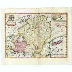
A New Map of Great Tartary and China with the adjoining parts of Asia
Two insets show the land to the northeast of China, according to Jesuit information. The map stretches from northern Russia and Nova Zemlya in the northwest to Formosa in...
Date: Oxford, 1700
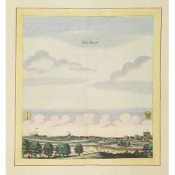
Döblen.
Very decorative and rare panoramic of Döblen in Sachsen.The engraver and publisher of prints, Mrs. Anna Beek of the Hague, enlarged the print and mounted it on larger p...
Date: The Hague, ca. 1700
![[Title page] Table Des Cartes etc: Du Sr. Sanson.](/uploads/cache/09204-250x250.jpg)
[Title page] Table Des Cartes etc: Du Sr. Sanson.
Large, powerfully engraved title page. Geographic scholars at work in a library are depicted along the bottom.Read more about title page [+]
Date: Amsterdam, 1700
![Bagdat le plan de Bagdat. [Manuscript plan of Bagdad]](/uploads/cache/45364-250x250.jpg)
Bagdat le plan de Bagdat. [Manuscript plan of Bagdad]
Manuscript plan of Baghdad, being a close copy of 'Les Six Voyages de Jean-Baptiste Tavernier en Turquie, en Perse et aux Indes' (1676). With a lettered key 1-16 to impor...
Date: France, ca. 1700
Stättlein Saltza.
Very decorative and rare panoramic town view of Salzelmen Bad Salzemen, Bez. Magdeburg. The engraver and publisher of prints, Mrs. Anna Beek of the Hague, enlarged the pr...
Date: The Hague, ca. 1700
Seehaüsen.
Very decorative and rare panoramic of Seehausen, Altmark, Bez. Magdeburg .The engraver and publisher of prints, Mrs. Anna Beek of the Hague, enlarged the print and mount...
Date: The Hague, ca. 1700
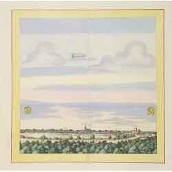
Calvorde.
Very decorative and rare panoramic of Calvörde, Bez. Magdeburg.The engraver and publisher of prints, Mrs. Anna Beek of the Hague, enlarged the print and mounted it on l...
Date: The Hague, ca. 1700
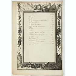
Table.
Index table page recto and verso of a world atlas.
Date: Paris, 1700
Templin
Very decorative and rare panoramic town view of Templin in Uckermark.The engraver and publisher of prints, Mrs. Anna Beek of the Hague, enlarged the print and mounted it ...
Date: The Hague, ca. 1700
Statt Garleben.
Very decorative and rare panoramic town view of Gardelegen in Altmark.The engraver and publisher of prints, Mrs. Anna Beek of the Hague, enlarged the print and mounted it...
Date: The Hague, ca. 1700
Newenwedel.
Very decorative and rare panoramic town view of Newenwedel i.d. Neumark .The engraver and publisher of prints, Mrs. Anna Beek of the Hague, enlarged the print and mounted...
Date: The Hague, ca. 1700
Stättl Zedenick.
Very decorative and rare panoramic town view of Zedenick a.d. Havel, Bez. potsdam.The engraver and publisher of prints, Mrs. Anna Beek of the Hague, enlarged the print an...
Date: The Hague, ca. 1700
Gloster Brüningen bei Halberstatt.
Very decorative and rare panoramic town view of Halberstatt.The engraver and publisher of prints, Mrs. Anna Beek of the Hague, enlarged the print and mounted it on larger...
Date: The Hague, ca. 1700
Stendalia Stendel
Very decorative and rare panoramic town view of Stendal, Bez. Magdeburg.The engraver and publisher of prints, Mrs. Anna Beek of the Hague, enlarged the print and mounted ...
Date: The Hague, ca. 1700

Amstelodami celeberrimi hollandiae emporii delineatio nova.
Frederik de Wit’s beautiful bird's-eye view of the city. The Amstel river is still open water flowing through the city's heart. Only near the Dam, has it been covered b...
Date: Amsterdam, c.1700
Lugdunum vulgo Lyon.
SCARCE bird's-eye view of Lyon. Adorned with a title cartouche at bottom left, a cartouche at bottom right containing the legend with key tables 1-98 and three coats of a...
- $1000 / ≈ €861
Date: Amsterdam, ca. 1700

Schlanium vulgo Schlani Bohemiae oppidum.
Very decorative and rare panoramic town view of Schlan, Schlanium s. Slany.The engraver and publisher of prints, Mrs. Anna Beek of the Hague, enlarged this print, origina...
Date: The Hague, 1700
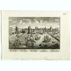
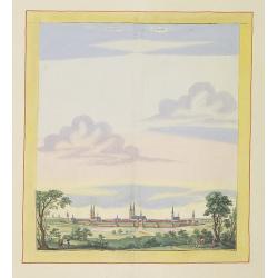
La Ville de la Rochelle, Capitale du pays d'Aunis. . .
A very decorative town view of La Rochelle.
- $350 / ≈ €301
Date: Paris, 1700
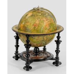
A very rare Louis XIV celestial globe by Guillaume De L'Isle, Paris, 1700, with his first address "Rue des Canettes".
A very rare Louis XIV celestial globe by Guillaume De L'Isle, Paris, 1700, with his first address "Rue des Canettes". To our knowledge, the only known exampl...
Date: Paris, 1700

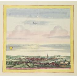
Alssleben.
The engraver and publisher of prints, Mrs. Anna Beek of the Hague, enlarged the print and mounted it on larger paper: she colored it in pastel colors, adding extensive cl...
Date: The Hague, ca. 1700
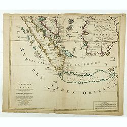
Le Royaume de Siam avec les Royaumes. . .
Influential map of the Malay peninsula, Sumatra, Java and Borneo, centered on Singapore. Mortier incorporated information provided by the French Jesuits and charts the ro...
Date: Amsterdam, 1700
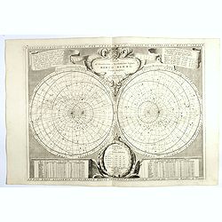
Planisferii Celesti, Calcolati Per L'Anno MDCC, Corretti, Et Aumenati Di Molte Stelle . . .
Double hemisphere celestial map showing a new and more scientific depiction of the heavens. The remarkable Vincenzo Coronelli (1650-1718), was a Franciscan Friar and appo...
Date: Venice, 1700
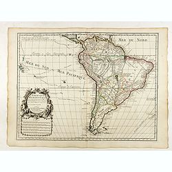
L'Amerique Meridionale Dressée sur les Observations de Mrs de l'Academie Royale des Sciences . . .
Rare state of " L’Amerique Meridionale. Chez l’Auteur sur le Quai de l’Horloge a la Courone de Diamans avec Privilege du Roy pour 20 ans, 1700".Fine map o...
Date: Paris, 1700
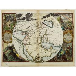
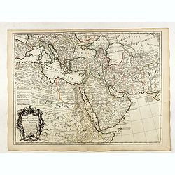
Orbis Per Creationem Institutus.
This is a very unusual map depicting the region from Asia Minor to India and including all of the Arabian Peninsula within a circle. The Garden of Eden is prominently dis...
- $750 / ≈ €646
Date: Amsterdam, 1700
![[Title page] Libellus Novus Politicus.. Pars Quinta.](/uploads/cache/38475-250x250.jpg)
[Title page] Libellus Novus Politicus.. Pars Quinta.
Very skilfully engraved title page from a rare work printed by Eberhard Kieser: Thesaurus Philo-Politicus. Das ist Politisches Schatzkästlein guter Herren und bestendige...
- $80 / ≈ €69
Date: Frankfurt, 1700
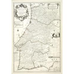
Le Portugal dedié au Roy.
Detailed oversized map of Portugal prepared by P. Placide Augustin, with fine title cartouche. Engraved by Inselin.Le Père Placide de Sainte-Hélène was the brother-in-...
- $300 / ≈ €258
Date: Paris, ca. 1700
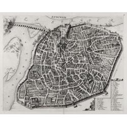
Avignon.
SCARCE bird's-eye view of Avignon (Provence) figuring the Popes' Palace and the fortifications. Adorned with a cartouche at bottom right containing the legend with key ta...
- $1000 / ≈ €861
Date: Amsterdam, ca. 1700
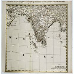
Carte d'une Partie des Indes Orientales, Etats du Mogol les Cotes de Malabar et de Coromandel.
A fine and highly detailed depiction of India and the surrounding region, this map extends from the Straits of Hormuz to the Gulf of Bengal. The Amsterdam publishing firm...
Date: Amsterdam, 1700

Collection of rubbings with portraits and biographies of famous Chinese philosophers, poets and legendary wise old men.
Collection of portraits and biographies of famous Chinese philosophers, poets, and legendary wise older men. All portraits and text are original rubbings from stone table...
- $15000 / ≈ €12919
Date: China or Korea, c. 1701
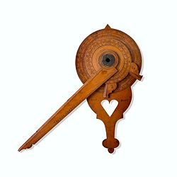
Wooden Nocturnal in boxwood and brass.
This exceptional nocturnal is made of boxwood and brass, the wheels maintained by a central nut, presents an annual calendar divided into months and days, an hour disc,...
Date: England, Thomas Cooper, dated 1701
Carte de la Turquie de l'Arabie et de la Perse.
Very rare state with the address : Chez l’Auteur, Rue des Canettes prez St. Sulpice. Avec Privilège, 1701". This early state with "rue des Canettes" imp...
Date: Paris, 1701

L'Amerique Septentrionale.
Very rare map, from "Metaphaste Barbao, Descriptio Indiae Occidentalis et America Nova" published by Henrico Verdussen.The map is a copy of Guillaume de L'Isle'...
Date: Antwerp, 1702
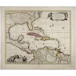
Insulae Americanae in Oceano Septentrionali..
A particularly handsome map portraying the south-eastern U.S., the Caribbean islands, part of Mexico, Central America, Florida (called tegesta Prov. ) and part of South A...
- $1500 / ≈ €1292
Date: Amsterdam, 1702
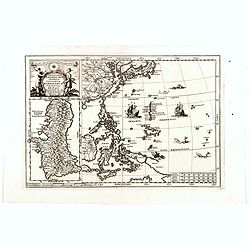
Nova Et Vera Exhibitio Gerographica Insularum Marianarum . . .
Attractive map of the Philippines, Japan, Korea and Indonesia with an inset of the island Guam, by the Jesuit Heinrich Scherer, printed in for Scherer's 'Atlas Novus'. Se...
- $1200 / ≈ €1034
Date: Munich, c.1702
Carte Des Pays Bas Catholiques Dressée. . .
Rare with the address "Chez l’Auteur sur le Quai de l’Horloge a la Cour. ne de Diamans, 1702. Se trouve à Amsterdam chez L. Renard Libraire près de la Bourse.&...
Date: Paris, 1702
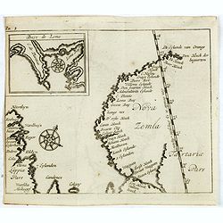
(Map of Nova Zembla with inset of Baye de Loms.)
Map of Nova Zembla with inset of Baye de Loms (5x7mm.). From the French reissue of the account of early Dutch voyages first published in 1608 by Commelin. The French tran...
- $110 / ≈ €95
Date: Amsterdam, E. Roger, 1702

Insula S. Laurentii.
Miniature map of Madagascar, with four inset maps. From the French reissue of the account of early Dutch voyages first published in 1608 by Commelin. The French translati...
Date: Amsterdam, E. Roger, 1702
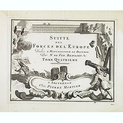
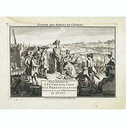
(Title page) Suite des Forces del'Europe. . .
Very decorative title page from the Amsterdam edition of ca. 1702 by Pieter Mortier (1661-1711) of de Fer's important work "Les forces de l' Europe."This plate ...
- $150 / ≈ €129
Date: Amsterdam, c.1702
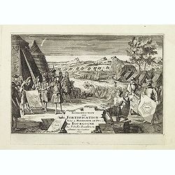
(Title page) Introduction a la Fortification. . .
Very decorative title page from the Amsterdam edition of ca. 1702 by Pieter Mortier (1661-1711) of de Fer's important work "Les forces de l' Europe."This plate ...
- $150 / ≈ €129
Date: Amsterdam, c.1702
(Title page) Troisieme Partie de L'Introduction a la Fortification. . .
Very decorative title page from the Amsterdam edition of ca. 1702 by Pieter Mortier (1661-1711) of de Fer's important work "Les forces de l' Europe."This plate ...
- $225 / ≈ €194
Date: Amsterdam, c.1702
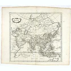
Asia.
Map of Asia. Peter Heylin or Heylyn (29 November 1599 – 8 May 1662) was an English ecclesiastic and author of many polemical, historical, political and theological trac...
- $450 / ≈ €388
Date: London, 1703
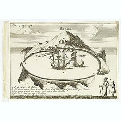
Solor / A la Baye de Solor.
Decorative map of the Bay of Solor. With a lettered key (A - E). Solor is a volcanic island located off the eastern tip of Flores island in the Lesser Sunda Islands of In...
- $120 / ≈ €103
Date: Amsterdam, E. Rogers, 1703
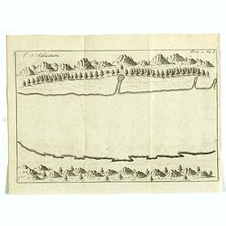
I. S. Sebastien.
Simplified bird's-eye view of Ilha de São Sebastiao, part of an archipelago off the southern coast of Brazil 210 miles from Rio de Janeiro. It was discovered on January ...
- $225 / ≈ €194
Date: Amsterdam, E. Roger, 1703
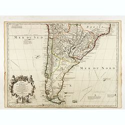
Carte du Paraguay du Chili.
A finely engraved, detailed map of the southern half of South America. Prepared by de l'Isle with the imprint "Chez l’Auteur sur le Quai de l’Horloge avec Privil...
Date: Paris, L. Renard, 1703

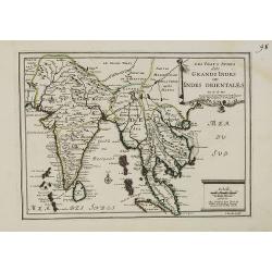
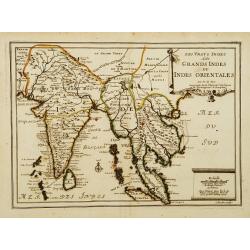
Les Vrays Indes dits Grandes Indes ou Indes Orientales Par N. de Fer. Geographe de Sa Majeste Catoliques et de Monseigneur le Dauphin.
Detailed map on India, Thailand, the Malay Peninsular and the south coast of China up to Macao. The map was engraved by C. Inselin.
- $300 / ≈ €258
Date: Paris, 1703
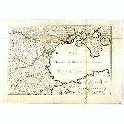
(Mer Noire ou Maieure, Pont Euxin.)
Very rare and detailed map of the Black Sea area prepared by Placide de Sainte-Hélène (1648-1734). and engraved by Claude-Auguste Berey (1651-1732).The map is of partic...
- $350 / ≈ €301
Date: Paris, 1703
![[No title] Germany and Poland.](/uploads/cache/37522-250x250.jpg)
[No title] Germany and Poland.
A untitled miniature map od Gemany and Poland by the German cartographer Johann Ulrich Müller. The map shows the regions of present-day Poland and Germany.For such a sma...
- $180 / ≈ €155
Date: Ulm, c 1703
Les Vrays Indes dits Grands Indes ou Indes Orientales Par N. de Fer. Geographe de Sa Majeste Catoliques et de Monseigneur le Dauphin.
Detailed map on India, Thailand, the Malay Peninsular and the south coast of China up to Macao. The map was engraved by C. Inselin.
- $500 / ≈ €431
Date: Paris, 1703
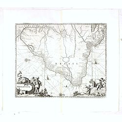
Brasilia.
Very fine decorative map od Brazil with west to the top. From the book "A Collection of Voyages and Travels" by Churchill and the map came from the part contain...
- $550 / ≈ €474
Date: London, Printed for A. and J. Churchill, 1703
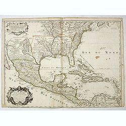
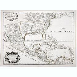
Carte du Mexique et de la Floride des Terres Angloises et des Isles Antilles...
Scarce state not listed by Tooley with the imprint : "Chez l’Auteur sur le Quai de l’Horloge a la Cour.r de Diamãs. Avec Privilege du Roy po.r 20 ans, 1703"...
Date: Paris, 1703
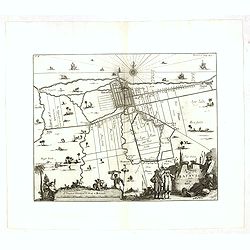
A Mapp of Batavia with all itts Forts.
Wonderful, scarce, and decorative plan of present-day Jakarta, showing the City and its immediate environs, the surrounding rice fields intersected by a network of waterw...
Date: London, Printed for A. and J. Churchill, 1703
![[Breisach] Profil de la ville de Brisac scituée sur le Rhin dans le Brisgau prise par l'armée du Roy commandée par Monseign.r le duc de Bourgogne le 6.e septembre 1703.](/uploads/cache/43496-250x250.jpg)
[Breisach] Profil de la ville de Brisac scituée sur le Rhin dans le Brisgau prise par l'armée du Roy commandée par Monseign.r le duc de Bourgogne le 6.e septembre 1703.
Scene of the siege of Breisach in 1703 by Marshal Tallard during the Spanish Succession War.
- $120 / ≈ €103
Date: Paris, 1703
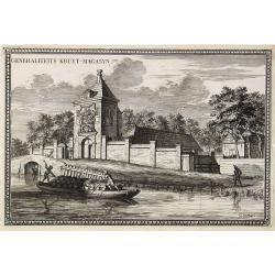
Generaliteits Kruyt-Magasyn.
The print depicts the gunpowder storage in Rotterdam. A most decorative item.
- $50 / ≈ €43
Date: Amsterdam, 1703
La Baye de l'Isle & ville de Borneo.
Uncommon map of a Bay on the island of Borneo. From the French reissue of the account of early Dutch voyages first published in 1608 by Commelin. The French translation w...
- $100 / ≈ €86
Date: Amsterdam, E. Roger, 1703
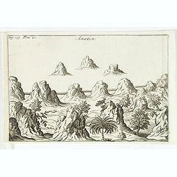
Anabon. (Ambon)
A fanciful view of a landscape on the island Ambon. From the French reissue of the account of early Dutch voyages first published in 1608 by Commelin. The French transla...
- $120 / ≈ €103
Date: Amsterdam, E. Rogers, 1703
Les Vrays Indes dits Grands Indes ou Indes Orientales Par N. de Fer. Geographe de Sa Majeste Catoliques et de Monseigneur le Dauphin.
Detailed map on India, Thailand, the Malay Peninsular and the south coast of China up to Macao. The map was engraved by C. Inselin.
Date: Paris, 1703
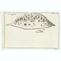
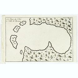
I. S. Clara.
Island "S. Clara" in Brazil just a few degrees north of the Tropic of Capricorn. From volume two of the French reissue of the account of early Dutch voyages. T...
- $150 / ≈ €129
Date: Amsterdam, E. Roger, 1703
Carte du Canada ou de la Nouvelle France.
Fourth state of the map of Canada published by Delisle with the imprint "sur le Quai de l’Horloge a l’Aigle d’Or avec Privilege pour 20 ans, 1703". Beneat...
Date: Paris, 1703
Carte du Mexique et de la Floride.
Third state, with "Quai de l'Horloge" imprint. Renard’s imprint has been erased”. It was the first printed map to portray accurately the course and mouth of...
Date: Paris, 1703
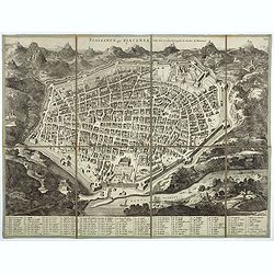
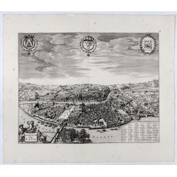
Plaisance ou Piacensa, ville de la Lombardie, capitale du duché de Plaisance.
Rare and beautiful bird's-eye plan of the town of Plaisance in Lombardy, accompanied by 120 key to the most important points in town. Second state with " XIX" i...
- $400 / ≈ €345
Date: Amsterdam, 1704

II Regno di Francia Diviso in Provincie e Governi ove su`Le Frontiere di esso Rappresenta il Teatro della Guerre di Flandria Germania Savoja e Lombardia.
Very rare wall map of France depicting "The Kingdom of France divided into Provinces and Governments with on its borders the Theater of War of Flanders, Germany, Sav...
Date: Naples, 1704
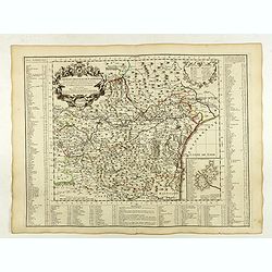
Carte du Diocese de Narbonne.
Topographically detailed map of the Narbonne diocese in southwestern France. Includes major roads and is supplemented with an extensive index. Inset map plan of the forti...
Date: Paris, 1704

Nieuwe gelyk Graadige Paskaart van de Kust van Guiana in West-Indien.
Detailed chart of Guiana in South America. Two scales are given in both maps: Dutch, French and English nautical miles.The inset chart provide detailed view of the Camopi...
- $650 / ≈ €560
Date: Amsterdam, 1684 - 1704
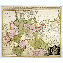
Regni Borussiae et Electoratus Brandenburgici, Ceterarum que, Quae Fridirici Reg. Bor. sceptro reguntur nec non finitimarum Prov. Delineatio. . .
Rare post-route map covering Germany, Poland, the Low Countries, and Czechoslovakia. The map gives in detail the German postal routes and postal stations. Within the lowe...
- $750 / ≈ €646
Date: Amsterdam, 1704