Browse Listings in Europe
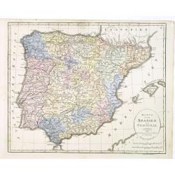
Karta öfver Spanien och Portugal.
An very rare map of Spain and Portugal with Swedish text. This is an updated version of his map of 1819 and is now dated 1833.From his atlas "Geographisk Hand-Atlas&...
- $100 / ≈ €86
Date: A. Wiborgs förlag, Stockholm, ca. 1848
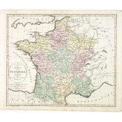
Karta öfver Frankrike.
An very rare map of France with Swedish text. This is an updated version of his map of 1819 and is now dated 1831.From his atlas "Geographisk Hand-Atlas" first ...
- $100 / ≈ €86
Date: A. Wiborgs förlag, Stockholm, ca. 1848
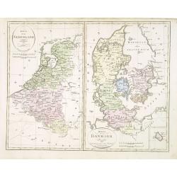
Karta öfver Nederland. / Karta öfver Danmark.
An very rare map of The Low Countries and Denmark with Swedish text. This is an updated version of his map of 1820 and is now dated 1832.From his atlas "Geographisk ...
- $110 / ≈ €95
Date: A. Wiborgs förlag, Stockholm, ca. 1848
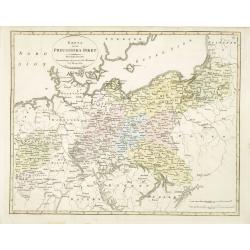
Karta öfver Preussiska riket.
An very rare map of Eastern part of Germany, with Pomerania and part of present-day Poland with Swedish text. This is an updated version of his map of 1820 and is now dat...
- $150 / ≈ €129
Date: A. Wiborgs förlag, Stockholm, ca. 1848
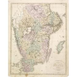
Karta öfver södra delen af Sverige.
An very rare map of Sweden with Swedish text. This is an updated version of his map of 1822 and is now dated 1839. In upper right corner Suppl. 1.From his atlas "Geo...
- $150 / ≈ €129
Date: A. Wiborgs förlag, Stockholm, ca. 1848
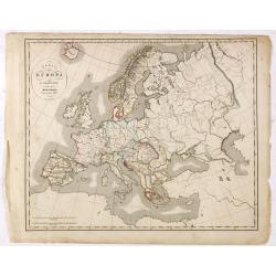
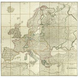
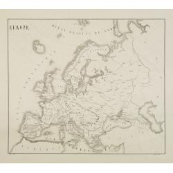
Karta öfver Europa.
An very rare map of Europe with a Swedish text. The map is dated 1839.Published as a supplement map in his atlas "Geographisk Hand-Atlas" first published in 181...
- $75 / ≈ €65
Date: A. Wiborgs förlag, Stockholm, ca. 1848
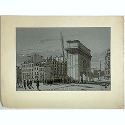
La Porte de S. Martin 24 Juin 3 heures du matin.
A view of St. Martin a well known place in Paris, by the French draughtsman André Durand.
- $100 / ≈ €86
Date: Paris, 1848
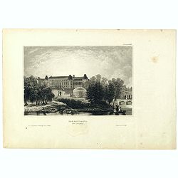
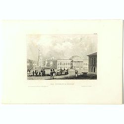
Czaritzana bei Moskau. (Tsaritsyno In Moscow)
Steel engraving with a panoramic view of the Tsaritsyn Palace In Moscow, published in "Meyers Universum oder Abbildung und Beschreibung des Sehenswerthesten und Merk...
- $20 / ≈ €17
Date: Hildburghausen, 1848
Das Zeughaus in Moscau.
Steel engraving of the Kremlin, published in "Meyers Universum oder Abbildung und Beschreibung des Sehenswerthesten und Merkwürdigsten der Natur und Kunst auf der g...
- $25 / ≈ €22
Date: Hildburghausen, 1848
Kloster des Ivan Velekoi in Moscau.
Steel engraving of the Kremlin, published in "Meyers Universum oder Abbildung und Beschreibung des Sehenswerthesten und Merkwürdigsten der Natur und Kunst auf der g...
- $25 / ≈ €22
Date: Hildburghausen, 1848
Kertsch im südlichen Russland. (Kerch)
Steel engraving with a panoramic view of the town of Krech, published in "Meyers Universum oder Abbildung und Beschreibung des Sehenswerthesten und Merkwürdigsten d...
- $15 / ≈ €13
Date: Hildburghausen, 1848
Zarskoe. (Tsarskoye Selo)
Steel engraving with a panoramic view of the town of Zarskoe, published in "Meyers Universum oder Abbildung und Beschreibung des Sehenswerthesten und Merkwürdigsten...
- $20 / ≈ €17
Date: Hildburghausen, 1848
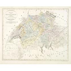
Karta öfver Helvetien.
An very rare map of Switzerland with Swedish text. This is an updated version of his map of 1820 and is now dated 1833.From his atlas "Geographisk Hand-Atlas" f...
Date: A. Wiborgs förlag, Stockholm, ca. 1848
![Bataille de Pultusk, le 26 Decembre 1806. [manuscript map]](/uploads/cache/38810-250x250.jpg)
Bataille de Pultusk, le 26 Decembre 1806. [manuscript map]
Manuscript map of the siege of Pultusk (located on the west bank of the River Narew approximately 50 kilometres (31 mi) north of Warsaw), on 26 December 1806. With a colo...
- $1750 / ≈ €1511
Date: Breda, 1849
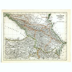
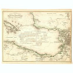
Der Kaukasische Istmus . . .
Detailed contemporary colored map of the countries of the Caucasus Mountains. Steel engraving appeared in "Meyer's Lexicon. Atlas der Geographie". Engraved by C...
Date: Hildburghausen, 1849
Carta geografica statistica e stradale d'Europa diseguata ed insica da Stanislao Stucchi. . . in Milano 1849.
Large engraved folding map of Europe (1545x1570 mm), consisting of 54 plates linen backed, the boundaries in early hand-color.Stanislao Stucchi was an engraver and printe...
- $600 / ≈ €518
Date: Milan, Turin, 1849
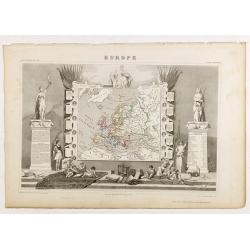
Europe.
While the map itself is quite simple without a great deal of detail, the surrounding engravings make this one of the most decorative 19th century maps. The map is frame...
- $150 / ≈ €129
Date: Paris 1850
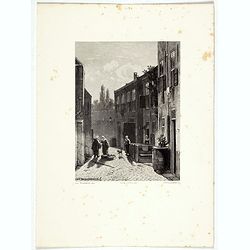
Dordrecht.
Attractive lithography showing a Dutch street scene, printed by C.W.Mieling and lithographed by Jan Weissenbruch. Published in Kunst Kroniek .
- $50 / ≈ €43
Date: The Hague 1850

Saint Petersbourg. Maison de bienfaisance, appartenant à Mr Anatole de Demidoff. . .
Beautiful lithography showing the house of Anatole de Demidoff in Saint Petersburg.
Date: Paris, c. 1850

Nice Vue prise audessus de Montalban.
Beautiful view of Nice from the book "l'Italie à vol d'oiseau".
Date: Paris, 1850
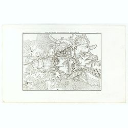
Plan du Champ de Bataille de la Moskowa
Prepared by Thunot Duvotenay (1796-1875), a French geographer and publisher. Detailed map taken from: "Thiers, Atlas de l' Histoire du Consulat et de l' Empire"...
- $150 / ≈ €129
Date: Paris, 1850

(View of the Moscow Kremlin, seen from the Moskva River in the south).
Anonymous, likely Russian School gouache drawing of Moscow Kremlin. The Kremlin is depicted in a typical 19th century romantic style and is seen from the Moskva river in ...
Date: Russia, ca. 1850
Der Kreml in Moscau.
View of Moscow with in the background the Kremlin. Original steel engraving, published by Bibliographisches Institut Hildburghausen. Engraved by H.Hauser.
- $30 / ≈ €26
Date: Hildburghausen, 1850
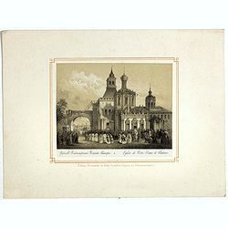
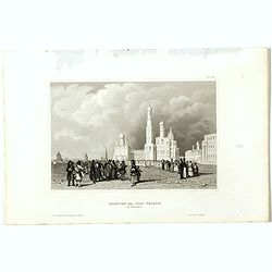
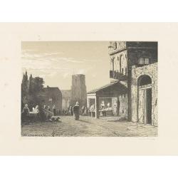
Eglise de Notre Dame de Vladimir.
The church of Holy Mary in Vladimi with in the foreground a ceremony with bishops, monks and faithful viewers. Below a caption in French and in Cyril.
- $45 / ≈ €39
Date: Russia or France, ca. 1850
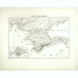
Carte de la Crimée.
Attractive map of Crimea with inset plan of Sevastopol, prepared by Alexandre Aimé Vuillemin (1812-1886). A road system and the ferry lines are drawn in.Engraved by Jaco...
- $150 / ≈ €129
Date: Paris, ca. 1850
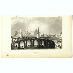
Moscau von der Kreml-Seite.
Steel engraving with a panoramic view of the Kremlin in Moscow, published in "Meyers Universum oder Abbildung und Beschreibung des Sehenswerthesten und Merkwürdigst...
- $20 / ≈ €17
Date: 1850
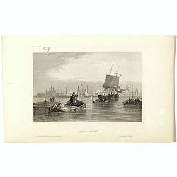
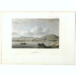
Archangel.
Steel engraving of Archangel, published by the German publishing company Bibliographisches Institut which was founded 1826 in Gotha by Joseph Meyer, moved 1828 to Hildbur...
- $25 / ≈ €22
Date: Hildburghausen, 1850
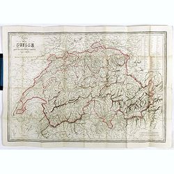
Carte de la Suisse . . .
Detailed canvas map of Switzerland.
Date: Paris, 1850
Dutch street scene.
Attractive lithography showing a Dutch street scene, lithographed by F.H. Weissenbruch after a painting of Jan Weissenbruch.
- $50 / ≈ €43
Date: The Hague, 1850
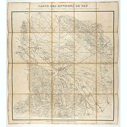
Carte des environs de Pau. . .
Folding map of Pau and its surroundings, being a reduced version of the map by Comte Dulong de Rosnay and engraved by Nicolas Delamare and published by Lafon.More about f...
- $75 / ≈ €65
Date: Pau, Lafon, 1840-1850
![[Original drawing: Fisher's ships on the beach of Scheveningen.]](/uploads/cache/984-250x250.jpg)
[Original drawing: Fisher's ships on the beach of Scheveningen.]
Unique pencil drawing: Typical Dutch beach life with flat-bottomed ships on the beach of Scheveningen. Signed in the lower right corner and on the back site with P.A....
Date: c. 1850
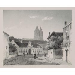
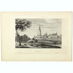
Arnhem
Attractive lithography showing a street scene in Arnhem. Lithographed by Jan Weissenbruch, published by C.W. Mieling, included in Kunst Kroniek.
- $65 / ≈ €56
Date: The Hague, 1851
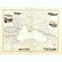
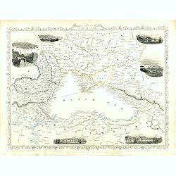
Black Sea.
Decorative steel engraved map of the Black Sea with inset views of Sebastopol and Odessa. There are also vignettes of Constantinople, Sinope and Varna. Taken from "T...
- $110 / ≈ €95
Date: London, London Printing and publishing Company of London, ca. 1851
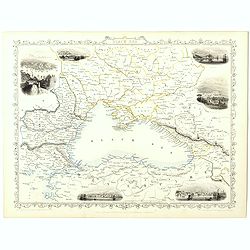
Black Sea.
Decorative steel engraved map of the Black Sea with inset views of Sebastopol and Odessa. There are also vignettes of Constantinople, Sinope and Varna. Taken from "T...
Date: London, London Printing and publishing Company of London, ca. 1851
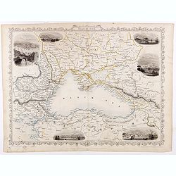
Black Sea.
Decorative steel engraved map of the Black Sea with inset views of Sebastopol and Odessa. There are also vignettes of Constantinople, Sinope and Varna. Taken from "T...
- $90 / ≈ €78
Date: London, London Printing and publishing Company of London, ca. 1851
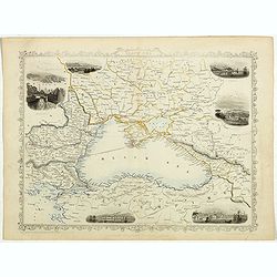
Black Sea.
Decorative steel engraved map of the Black Sea with inset views of Sebastopol and Odessa. There are also vignettes of Constantinople, Sinope and Varna. Taken from "T...
- $90 / ≈ €78
Date: London, London Printing and publishing Company of London, ca. 1851
Black Sea.
Decorative steel engraved map of the Black Sea with inset views of Sebastopol and Odessa. There are also vignettes of Constantinople, Sinope and Varna. Taken from "T...
Date: London, London Printing and publishing Company of London, ca. 1851

Black Sea.
Decorative steel engraved map of the Black Sea with inset views of Sebastopol and Odessa. There are also vignettes of Constantinople, Sinope and Varna. Taken from "T...
- $90 / ≈ €78
Date: London, London Printing and publishing Company of London, ca. 1851
Europe.
Fine manuscript map of Europe with relief shown pictorially. Signed by the author in the lower right corner.Lower left Juillet 1852.
- $150 / ≈ €129
Date: Paris, 1852
![Dépt. De L'Aude. N°10. [ Carcassonne ]](/uploads/cache/27089-250x250.jpg)
Dépt. De L'Aude. N°10. [ Carcassonne ]
Map of the Aude region, centered on the town of Carcassonne. Reaching to the right till the Mediterranean.Lovely map from one of the last decorative atlases of the ninete...
Date: Paris, A. Combette, 1852
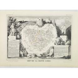
Dépt. De La Haute Loire. N°42.
Map of the Upper Loire region in France.Lovely map from one of the last decorative atlases of the nineteenth century.The rather simple map is framed by medallion portrait...
- $50 / ≈ €43
Date: Paris, A. Combette, 1852
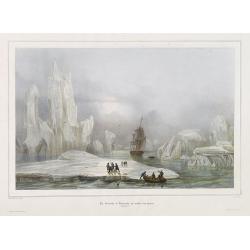
La Corvette la recherche au milieu des glaces.
Beautiful lithograph by A. Mayer and Bayot of the corvette "La recherche" surrounded by Ice. Published by Arthus-Bertrand and Lemercier in Paris.From Joseph Pau...
Date: Paris. Arthus-Bertrand, 1838-1852
![Dépt. du Morbihan. N°. 55. [ Morbihan, Belle-Ile ]](/uploads/cache/43041-250x250.jpg)
Dépt. du Morbihan. N°. 55. [ Morbihan, Belle-Ile ]
Map of the Morbihan region in Brittany. Including "Belle-Ile".Lovely map from one of the last decorative atlases of the nineteenth century.The rather simple map...
Date: Paris, A. Combette, 1852
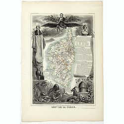
Dépt. De La Corse. N°19.
Map of the Corsica island.Lovely map from one of the last decorative atlases of the nineteenth century.The rather simple map is framed by elaborate border showing regiona...
- $150 / ≈ €129
Date: Paris, A. Combette, 1852
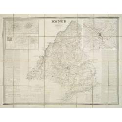
Madrid por el Teniente Coronel, Capítan de Ingenieros D. Francisco Coello. Las notas estadisticas é historicas han sido escritas por D. Pascual Madoz. Madrid 1853.
Second edition of this important and very detailed map of the region of Madrid prepared by Francisco Coello (1822 - 1898) and improved by Pascual Madoz (1806 - 1870). Eng...
- $400 / ≈ €345
Date: Madrid, 1853

Kronstat From The Russian Survey . . .
Scarce chart of the Island of Kronstat, the primary defensive position for the Russian Navy in defense of Russia's Czarist Capital of St. Petersburg.Published on the eve ...
- $500 / ≈ €432
Date: London, 1853

The town & harbour of Sevastopol with the batteries & approaches. . .
Rare colored linen backed map showing the harbour and town of Sevastopol, with soundings. In upper left corner a inset map (65x150mm) of the Black Sea. In bottom part a l...
Date: London, March 27th, 1854

The Crimea, chiefly from surveys made by order of the Russian government. . .
Map of Crimea and the Sea of Azov. In lower right corner two inset maps showing Sebastopol inlet and harbour and a second one with the Black Sea. This second maps shows t...
Date: London, 1854
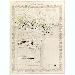
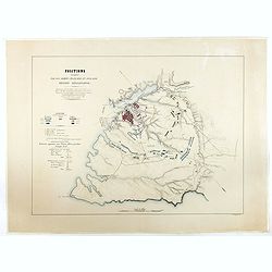
Plan of the battle of Alma.
Fine plan drawn and engraved by John Rapkin "from English and French Official Documents" Published 1858 by the London Printing and Publishing Co., London. Shows...
- $150 / ≈ €129
Date: London, 1854
Siege of Sebastopol.
Detailed map of the Siege of Sebastopol. After the Battle of the Alma, the Allies proceeded to Sebastopol and commenced the Siege on September 26th, 1854. This is a steel...
- $150 / ≈ €129
Date: London, 1854
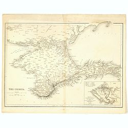
The Crimea.
Map of Crimea and the Sea of Azov. In lower right corner inset map showing Sebastopol region.
- $50 / ≈ €43
Date: London, 1854
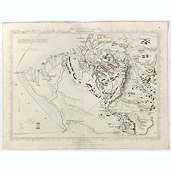
Positions occupées par les armées françaises et anglaises devant Sevastopol.
Map of the French and English armies positions in Sebastopol.Read more about The Crimean War - The Siege of Sevastopol. [+]
- $350 / ≈ €302
Date: Paris, 1854
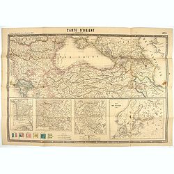
Carte d'Orient par Kraminski ingénieur.
Large map of Orient, with an insert of four maps (Constantinople plan - Map of Europe - Map of Russia - Plan of Baltic sea). With flags in the lower left part. color key ...
Date: Paris, 1854
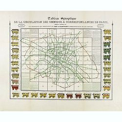
Tableau synoptique de la circulation des omnibus à correspondances de Paris.
Synoptic table of the circulation of omnibuses with connections of Paris indicating at first sight the resources presented by the one hundred and sixty-seven connections ...
- $750 / ≈ €647
Date: Paris, ca. 1854

(Lübeck) Lvbeca vrbs. imperialis libera. civitatvm. Wandalicarvm. . . .
Impressive, more than 3 meters wide panoramic town view after a woodblock engraving from Elias Diebel, initially made in 1552. Of this original woodblock, Bachmann mentio...
Date: Germany, c. 1855

The Crimea by James Wyld Geographer to the Queen & H.R.H. Prince Albert.
Fourth edition of this folding map of the Crimea. In upper right corner an inset map of the areas around the Black Sea; "The Town & Harbor of Sevastopol with the...
Date: London, 1855

Military map of the countries between Odessa & Perekop with the stations of the Russian forces.
Rare colored linen-backed map showing Russian troop positions and Odessa Batteries. On the inside of the cover a list of "Wyld's list of recent publications : seat o...
Date: London, ca. 1855
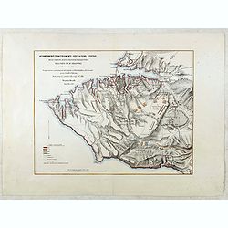
Accampamenti, Trinceramenti, ed Operazioni di Assedio...
Detailed plan of the Allied siege of Sebastopol in 1854-1855 during the Crimean War, showing the allied French, English and Turkish positions, and those of the Russians, ...
- $400 / ≈ €345
Date: Naples, 1855
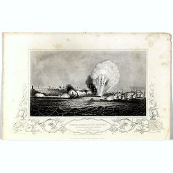
Bombardment of Odessa by the English and French April 22 1854, explosion on the imperial mole . . .
Scene from the Crimea war, showing a bombardment of Odessa, 22nd April 1854 (during Crimean War, 1853-56), by English and French forces, explosion imperial mole (breakwat...
- $55 / ≈ €47
Date: London, 1855
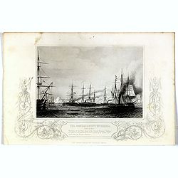
Bombardment of Odessa by the English and French April 22 1854, The boats of the British Fleet going to the French steamer 'Vauban' . . .
Scene from the Crimea war, showing the bombardment of Odessa, 22nd April 1854 (during Crimean War, 1853-56), engraving by G. Greatbach after drawing by H.W. Nicholls, c. ...
- $30 / ≈ €26
Date: London, 1855
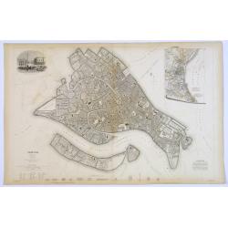
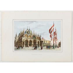
Venice.
A lovely steel engraved plan, on 2 sheets, of Venice by the Society for the Diffusion of Useful Knowledge (SDUK). This English philanthropic enterprise was entirely devot...
Date: London, 1855
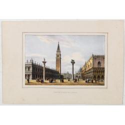
Petite Place de S. Marc.
View of St Mark’s Square, lithographed in Venice by G. Brizeghel, published here with French captions in "Album delle principali vedute di Venezia". In origi...
Date: Venice, c.1855
Basilique S. Marc.
St Mark’s Basilica, lithographed in Venice by G. Brizeghel, published here with French captions in "Album delle principali vedute di Venezia". In original co...
Date: Venice, c.1855
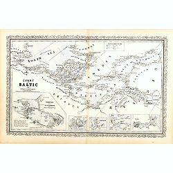
Chart of the Baltic from admiralty & Russian surveys.
Uncommon map of the Baltic Sea and adjacent countries (Denmark, Sweden, Finland, Estonia, Latvia, Lithuania, Poland, Germany) with five vignettes to illustrate the respec...
- $300 / ≈ €259
Date: Pennsylvania, ca. 1856
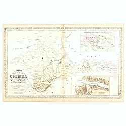
A Complete Map of the Crimea Showing the Military and Carriage Roads with Distances from Various Points of the Western Coast From English & Russian Surveys. . .
Uncommon map of Crimea with (inset maps) Sebastopol Harbor, and Map Showing the relative Position of the Crimea with the Seat of War. From Desilver's "A New Universa...
- $300 / ≈ €259
Date: Pennsylvania, ca. 1856
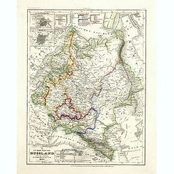
Das Europäische Russland nebst den asiatischen Provinzen diesseit des Ural. 1849.
Detailed map of Russia, with inset plans of St. Petersburg and Moscow with extensive key to the different provinces. The map was according to a text revised in 1856.From ...
Date: Hildburghausen / Philadelphia 1856
Kriegs- und Spezialkarte vom Finnischen Meerbusen von Kronstadt bis St. Petersburg 1856.
Interesting and detailed map with Kronstadt on the left and St. Petersburg on the right. In the center is information about the war and the listing of some major monument...
- $40 / ≈ €35
Date: Hildburghausen, 1856
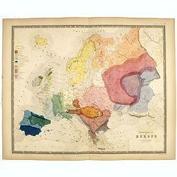
Ethnographic map of Europe by dr. Gustaf Kombst.
Original steel engraving with original hand coloring. A map showing the various ethnicities across Europe with a color key, according to Dr. Gustaf Kombst, published by A...
Date: William Blackwood and Sons, Edinburgh & London, 1856

Provincie Noord-Braband. / Breda, de Langstraat. . .
Decorative and uncommon custume plate lithographed by R. de Vries and published by Frans Buffa & Zonen in Amsterdam. A group of 4 women from the area of Baronie van B...
Date: Amsterdam, 1857

Provincie Noord-Braband.
Decorative and uncommon costume plate lithographed by Desguerrois & Co. and published by Frans Buffa & Zonen in Amsterdam. 12 illustrations of Brabant costumes: 1...
Date: Amsterdam, 1857
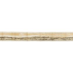
Panorama della Costa e delle Isole di Dalmazia nei viaggi dei piroscafi del Lloyd Austriaco.
On 20 August 1838 the Austrian Lloyd inaugurated a line service from Trieste to the Mouth of Cattaro. In order to illustrate the route, the Company asked the Trieste pain...
- $2500 / ≈ €2158
Date: Trieste, Linassi, 1857
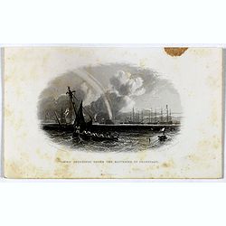
Taking soundings under the batteries of Cronstadt.
Steel engraving showing a small boat taking soundings under the batteries of Kronstadt from a drawing by J. W. Carmichael, engraved by E. Brandard. From "The History...
- $20 / ≈ €17
Date: London, Virtue, ca. 1857
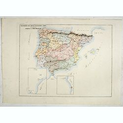
Circoscrizione delle province ecclesiastiche e Diocesinei regni di Spagna e Portogallo (Tav XLVI)
A large-format map of Spain and Portugal with its dioceses. The map is finely engraved and beautifully colored and was prepared by Girolamo Petri, a lawyer who served as ...
- $450 / ≈ €388
Date: Rome, 1858

Circoscrizione delle Provincie ecclesiastiche e Diocesi nei regni del Belgio, ed Olanda (Tav LXI)
This large-format map showing Belgium and Holland with its different dioceses. The map is finely engraved and beautifully colored and was prepared by Girolamo Petri, a la...
Date: Rome, 1858

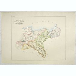
Provincia ecclesiastica di Malines nel Belgio (Tav LXII)
This large-format map of Belgium with its different dioceses. The map is finely engraved and beautifully colored and was prepared by Girolamo Petri, a lawyer who served a...
Date: Rome, 1858
![[The Netherlands] Provincia ecclesiastica di Utrecht Nell' Olanda (Tav LXIII)](/uploads/cache/44104-250x250.jpg)
[The Netherlands] Provincia ecclesiastica di Utrecht Nell' Olanda (Tav LXIII)
This large-format map of The Netherlands with its different dioceses. The map is finely engraved and beautifully colored and was prepared by Girolamo Petri, a lawyer who ...
- $250 / ≈ €216
Date: Rome, 1858
![[Czech Republic] Provincia ecclesiastica di Praga nell' Impero Austriaco (Tav LXVIII)](/uploads/cache/44108-250x250.jpg)
[Czech Republic] Provincia ecclesiastica di Praga nell' Impero Austriaco (Tav LXVIII)
A large-format map of Czech Republic centered on Prague with its different dioceses. The map is finely engraved and beautifully colored and was prepared by Girolamo Pet...
- $300 / ≈ €259
Date: Rome, 1858
Provincia ecclesiastica di Gnesna e Posnania nella Prussia Vicar.ti apost.cl di Sassonia e Dei Ducati Analtini (Tav LXXXII)
A large-format map of western Poland with its different dioceses. The map is finely engraved and beautifully colored and was prepared by Girolamo Petri, a lawyer who serv...
- $500 / ≈ €432
Date: Rome, 1858
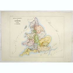
Provincia ecclesiastica di Westminster Londra in Inghilterra (Tav LXXXIV)
A large-format map of the British Isles with its different dioceses. The map is finely engraved and beautifully colored and was prepared by Girolamo Petri, a lawyer who s...
- $300 / ≈ €259
Date: Rome, 1858
![[Scotland] Vicariati Apostolici nella Scozia (Tav LXXXV)](/uploads/cache/44125-250x250.jpg)
[Scotland] Vicariati Apostolici nella Scozia (Tav LXXXV)
A large-format map of Scotland with its different dioceses. The map is finely engraved and beautifully colored and was prepared by Girolamo Petri, a lawyer who served as ...
- $350 / ≈ €302
Date: Rome, 1858