Browse Listings

Réseau aérien mondial.
"Sur les ailes d'Air France, découvrez le monde à votre tour" lithograph poster from AIR France. A great mid-century design by Air France advertising poster b...
Place & Date: Imprimerie Perceval Paris, ca. 1940-1950
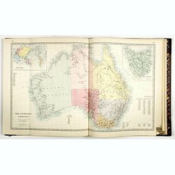
The Family Atlas Containing Eighty maps Constructed by Eminent Geographers. . .
Un unrecorded later edition of the S.D.U.K. Family atlas, with 80 plus one extra map. Most maps are single sheet but several are double page maps. Printed on heavy paper ...
Place & Date: London Edward Stanford, 1874
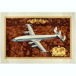
AIR France - Super constellation, Lockhead L - 10 - 49.
Promotional poster attributed to Lucien Boucher showing of a Lockhead L - 10 - 49 on a Mercator projection world map. The map depicts a pictorial map of the entire world ...
Place & Date: Perceval, Paris, 1953
![Sexta Etas Mundi. Ratisbonna. [Ratisbonne]](/uploads/cache/13549-250x250.jpg)
Sexta Etas Mundi. Ratisbonna. [Ratisbonne]
A very fine presentation of the city of Ratisbon, in Germany, centered on the cathedral (Dim. : 191 mm W : 525 mm).Overleaf a very nice view of Vienna, with two swans on ...
Place & Date: Nuremberg, 12 July 1493
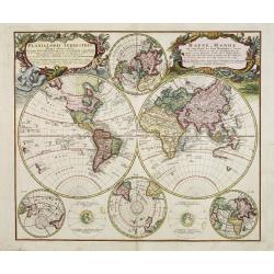
Planiglobii Terrestris - Mappe-Monde...
Word map in double hemisphere. In center two smaller hemispheres of the north and south pole are shown. Two interesting diagrams depict the earth as it would be seen from...
Place & Date: Nuremberg, 1746

Carte routière de l'Indochine. Des kilomètres en sécurité sur Goodrich.
Advertising poster for the brand Goodrich, showing a map of Indochina.Goodrich Corporation is a former American company specializing in civil and military aeronautical eq...
Place & Date: Paris, ca 1934

Poloniae, Lituaniaeq descriptio.
Fine general map of Poland. Rare; the second plate appearing in the post-1595 edition of the Theatrum. Only used until 1612.Based on the now-lost map of Waclaw Grodecki. ...
Place & Date: Antwerp, 1612

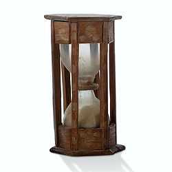
A ship's hour glass
The element common to celestial position-finding, the calculation of speed for dead reckoning and even everyday life at sea is the time: hence ways of determining and kee...
Place & Date: ca. 1790
Virginiae Partis Australis, et Floridae Partis Orientalis.
Blaeu based this map on the Mercator-Hondius of 1606. A number of geographical improvements, however were incorporated, although two large fictions lakes accompanied by e...
Place & Date: Amsterdam, 1640

Carte historique de la France, et l'Angleterre depuis la naissance de Jésus-Christ jusqu'à l'an 1700, qui contient en abrégé les événements principaux de ces royaumes pendant l'empire romain. . .
A rare wall map showing a chronological tree of French and English historical events from the year of the birth of Christ until 1700. The map is prepared by Jérôme Andr...
Place & Date: Paris, c. 1721

Guyana, Surinam, Amapa.
Very rare Ottoman printed map of Guyana, Suriname and Amapa. With Trinidad, an inset map of the mouth of the Rivers Essequibo, Courantyne, Suriname with Paramaribo.From C...
Place & Date: Üsküdar (Istanbul), 1803
-250x250.jpg)
Lyste vande prysen der goederen ingekoft by de Kamer. . .
Rare price list of meat, bacon, wheat, rye, butter, cheese, olive oil, Spanish wines, Bordeaux, brandy etc.On front page in letter press Lyste Van de Pryfen der Goederen,...
Place & Date: Amsterdam, 1685
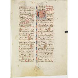
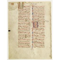
Leaf on vellum from an antiphonary.
A more than 600 years old antiphonary leaf, written in Besançon, in 1370. Musical notation on 4 bars, the staves are in red and the notes in black: numerous pen-flourish...
Place & Date: Besançon, 1370

Carte des Isles de Maiorque Minorque et Yvice dediée A.M. le Comte de Maurepas Ministre et secretaire d'Etat. . .
Fine map of the Baleares with much detail, in lower part inset "Plan du Port de Mahon du Fort St. Philippe et ses Fortifications". The map is dedicated to Jean ...
Place & Date: Amsterdam, after 1740
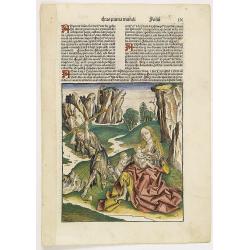
Prima Etas Mundi. IX (with Eve nursing Kain and Abel)
A very fine presentation of Eve nursing Kain and Abel. Adam is working (255x220 cm). VERSO a genealogy of Adam.Page from the richest illustrated Incunabel, the famous: Li...
Place & Date: Nuremberg, 12 July 1493

View of the harbour of Taloo, in the island of Eimeo.
John Webber View of the Harbour of Taloo on Moorea (Society Islands), from "Views in the South Seas" being a very important and early views depicting scenes enc...
Place & Date: London, Boydell and Co., 1808

The narta, or Sledge for burdens in Kamtschatka.
The narta, or Sledge for burdens in Kamtschatka, taken from "Views in the South Seas" being a very important and early views depicting scenes encountered while ...
Place & Date: London, Boydell and Co., 1808
A view in Oheitepeha Bay in the Island of Otaheite. (Tahiti)
A view of Vaitepiha Bay (Tahiti), with a mountainous landscape, with a river in the centre, a small canoe, Tahitian houses to the right, and a Tahitian couple in the left...
Place & Date: London, Boydell and Co., 1808

Histoire Socialiste.
Text includes “Imp. Centre de Propagande, des Républicains Nationaux, 102, rue Amelot, Paris (XIe), ou l’on peut se procurer cette affiche. Cette affiche ne peut êt...
Place & Date: Paris, 1931
![Aou, Tōkei. Kokugun Zenzu [Atlas of Provinces and Counties of Japan]. (volume 1 only)](/uploads/cache/63619-250x250.jpg)
Aou, Tōkei. Kokugun Zenzu [Atlas of Provinces and Counties of Japan]. (volume 1 only)
First edition. Very attractive early Japanese Atlas of detailed maps of Japanese regions compiled by six Japanese civilians in the eighth year (1837) of the Tenpō era (...
Place & Date: [Nagoya]: Tōheidō, Tenpō 8 = 1837
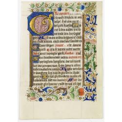
Leaf on vellum, from a manuscript book of hours.
Scatter border of flowers. Borders of very high quality, executed by an artist of the Ghent-Bruges school.VERSO: 19 lines of Dutch text in brown ink. A 6-lines capital &q...
Place & Date: Flanders, 1450

Virginiae Partis Australis, et Floridae Partis Orientalis.
Blaeu based this map on the Mercator-Hondius of 1606. A number of geographical improvements, however were incorporated, although two large fictions lakes accompanied by e...
Place & Date: Amsterdam, 1640

Tschopau.
Very decorative and rare panoramic of Tschopau.The engraver and publisher of prints, Mrs. Anna Beek of the Hague, enlarged the print and mounted it on larger paper: she ...
Place & Date: The Hague, ca. 1700

Wittstocs.
Very decorative and rare panoramic of Wittstock, Bez. Potsdam.The engraver and publisher of prints, Mrs. Anna Beek of the Hague, enlarged the print and mounted it on larg...
Place & Date: The Hague, ca. 1642

Japan (poster signed by Georges Mathieu)
Dedicated "Pour Benijs Boulanger" and signed "Georges Mathieu", in black marker. Decorative poster advertising flights to Japan made by Georges Mathie...
Place & Date: Paris, 1967
![[Albania, Bulgaria, Europe, Eastern, Greece, Hungary, Macedonia, Romania]](/uploads/cache/33868-250x250.jpg)
[Albania, Bulgaria, Europe, Eastern, Greece, Hungary, Macedonia, Romania]
Wood block printed map and one of earliest printed representation of Albania, Bulgaria, Europe, Eastern, Greece, Hungary, Macedonia, Romania prepared Martin Waldseemülle...
Place & Date: Vienna, Trechsel, G., 1525 -1541

Karte von Europa im Jahre 1870 nach einem französischen Holzschnitte.
Satirical illustration by Paul Hadol showing disposition of power in Europe at the beginning of 1870. Satirical print depicting a map of Europe in which the countries are...
Place & Date: Hamburg, Fuchs, 1914
A ship's hour glass.
Maritime hourglass with blown glass bulbs, orange sand, junction ring covered with cord, the circular ebony frame with six turned baluster columns.The invention of the ho...
Place & Date: The Netherlands, Germany, ca. 1750

Norimberga.
A spectacular panoramic of Nuremberg, with legends numbered from 1-39 in German. With the title in a banderol.After a design by Friedrich Bernhard Werner (1690-1776) who...
Place & Date: Augsburg, ca. 1720

Carte générale de L'Empire Ottoman en Europe et en Asie dressée par Henri Kiepert . . .
Large School wall map of Turkish Empire printed in chromo-lithography. Published by Dieter Reimer and printed by Ferdind Barth in Berlin. This rare map has two insets in ...
Place & Date: Berlin, Verlag von Dietrich Reimer, 1867

Nieuwe Kaart van het Eyland Sumatra..
Fine chart depicting the Island of Sumatra and the southern coasts of Malaysia from Quedo to Johore. North is orientated to the left of the page. Singapore is probably id...
Place & Date: Amsterdam, 1726

III. Gallia. Franckrych.
Very early wood cut printed map of France, North of river Rhine, Northern Italy. Coast of England from Dover to Cornwall. A ship, sea monsters and coats of arms are filli...
Place & Date: Zurich, Christoffel Froschover, 1548,1552-1566

Société de la Charité Maternelle à Paris. Plan de le ville de Paris, Divisé par Quartiers avec Nomenclature.
>Rare atlas de Paris dressé par E. Devrainne, divisé en 80 quartiers et colorié par Le Roux (Le Roux pinxit). Illustré d'une page de titre aux armes de Paris avec ...
Place & Date: Imprimerie Mercier, Clichy, 1876

CARTE de la Côte Occidentale de COREE, Plan Croquis de la Rivière HAN-KANG ou de SEOUL, depuis son Embouchure jusqu'à Séoul, dressée en 1866 ...
Uncommon chart of the Han-Kang River from its mouth to Seoul, prepared in 1866 by order of C.A. ROZE, Commander-in-Chief of the French " la Station des Mers de Chine...
Place & Date: Paris, 1868
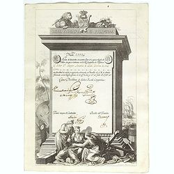
A scarce Real Compañia de Filipinas 250 Pesos deed issued in 1785
A scarce Real Compañia de Filipinas 250 Pesos deed issued in 1785. Share nº 23726, hand signed by several company officials.Engraved by Fernando Selma (1752-1810) after...
Place & Date: Spain, 1785

Malte Vue prise de la Mer. - Malta Vista lomada del mar.
Very decorative view of the Grand Harbour of Malta by Louis Lebreton, published in "Ports de Mer d’Europe" in 1859 by L. Turgis in Paris.This lithography show...
Place & Date: Paris, Turgis, 1859

Currus Veliferi Illmi. Pr. Mauritii Nassouvii. (Prince Maurits' sailing-carriage, designed by Simon Stevin. )
Prince Maurits' sailing carriages had been designed by Simon Stevin. The Prince, always accessible to new inventions of his old instructor, could not please the foreign a...
Place & Date: Amsterdam, 1649

Peregrinationis Divi Pauli Typus corographicus. . .
A splendid map depicting the travels of Paulus. With two fine scenes in top. Showing the countries along the Mediterranean, including Cyprus and Italy. A first edition wi...
Place & Date: Antwerp, 1595

Schlanium vulgo Schlani Bohemiae oppidum.
Very decorative and rare panoramic town view of Schlan, Schlanium s. Slany.The engraver and publisher of prints, Mrs. Anna Beek of the Hague, enlarged this print, origina...
Place & Date: The Hague, 1700

Sumatrae et insularum Locorumque nonnullorum circumiacentium. . .
Fine depicting the Island of Sumatra and the southern coasts of Malaysia from Quedo to Johore.North is orientated to the left of the page.Singapore is probably identifie...
Place & Date: Amsterdam, 1660

Turcici Imperii Imago.
The map shows the Ottoman Empire with Turkey, Black Sea, Mediterranean Sea, Arabia and North Eastern Africa. The map is decorated with a title cartouche and a portrait of...
Place & Date: Amsterdam, 1629
![.Tabula III Asiae. [Caucass and Armenia.]](/uploads/cache/27894-250x250.jpg)
.Tabula III Asiae. [Caucass and Armenia.]
Ptolemaic map of the region south of the Caucasus Mountains and between the Caspian Sea as far south as the headwaters of the Tigris River in the south and the Black Sea,...
Place & Date: Lyons, M. Servetus, 1535

Sardinia / Sicilia.. / Corfu / Zerbi.. / Elba / Malta. . .
Six very fine and early maps on one sheet. Including the islands of Sicily, Corfu, Sardinia, Zerbi (Djerba), Elba and Malta.The map of Malta has a sinking ship at Cala di...
Place & Date: Antwerp, 1570-1612

Statt Talbe an der Saal.
Very decorative and rare panoramic town view of Calbe a.d. Saale, Bez Magdeburg .The engraver and publisher of prints, Mrs. Anna Beek of the Hague, enlarged the print and...
Place & Date: The Hague, ca. 1642

Czaslaw.
Very decorative and rare panoramic of Czaslaw, Caslav, Tschslau in Böhmen.The engraver and publisher of prints, Mrs. Anna Beek of the Hague, enlarged the print and moun...
Place & Date: The Hague, ca. 1642
![[No title - Daniel's Dream map]](/uploads/cache/34784-250x250.jpg)
[No title - Daniel's Dream map]
Wood block print engraved by the famous engravers Jost Amman and Virgil Solis - with their initials in lower bottom of the map. This somewhat curious map of Europe, Afric...
Place & Date: Cologne, ca. 1564

Nieuwe Wassende Graadige Pas-kaart van de Kust van Guinea en Brasilia.
Rare two-sheet sea chart of the coasts of Brazil, West Africa and South Africa, published by Johannes Van Keulen (the younger), circa 1720.The chart shows the western coa...
Place & Date: Amsterdam, 1751

Kaart Van Nieuw Zeeland in de Jaaren 1769 en 1770 bezogt door den Luitenant J. Cook met het Schip De Endeavour.
A uncommon issue of this key map of New Zealand from the Dutch edition of Cook's map of New Zealand, published in 'Reize rondom de Waereld door James Cook', a Dutch editi...
Place & Date: Leyden, Amsterdam & The Hague: Honcoop, Allart & van Cleef, 1795-1801
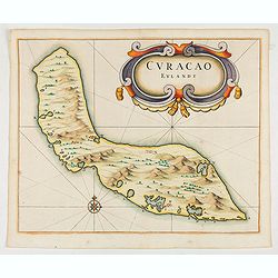
Curacao Eylandt.
One of the earliest separate maps of Curaçao. The map has nice topographical detail and features an ornate title cartouche. Published in de Laet's account of the history...
Place & Date: Amsterdam, 1644

Hollandia Comitatus.
Orientated west to the top of the sheet, this presents the County of Holland in the classical orientation for seventeenth-century maps, with Amsterdam at the center. The ...
Place & Date: Amsterdam, 1660

Rooseveld rekende verkeerd ! De vangarmen van De Dollarpoliep worden afgesneden. . .
An remarkable Anti-American Dutch World War II propaganda poster by Lou Manche, showing an pink octopus, representing the United States, with its tentacles being cut from...
Place & Date: The Netherlands, 1942

.Paskaarte om Achter Yrlandt om te Zeylen van Hitlant tot. . .
An eye-catching chart of Ireland, including the north of England and Scotland, with the West to the top.Pieter Goos (ca. 1616-1675) was one of the most important cartogra...
Place & Date: Amsterdam, 1673
![.[Germany and Poland]](/uploads/cache/33862-250x250.jpg)
.[Germany and Poland]
Wood block printed map and one of earliest printed representation of Germany, Poland, The Low Countries, Austria and Switzerland prepared by Martin Waldseemüller. Based ...
Place & Date: Vienna, Trechsel, G., 1525 -1541
Leaf on vellum from an antiphonary.
A more than 600 years old antiphonary leaf, written in Besançon, in 1370. Musical notation on 4 bars, the staves are in red and the notes in black: numerous pen-flourish...
Place & Date: Besançon, 1370
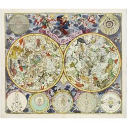
Planisphaerium Coeleste.
Magnificent double hemisphere celestial chart showing the northern and southern sky with constellations in allegorical form derived from Hevelius.A diagram in the upper l...
Place & Date: Augsburg, 1730

L'Arabia delineata sulle ultime osservazioni.
First edition on laid paper. Cassini’s splendid early map of Arabia.
Place & Date: Rome, 1797

Botanibay, Englischer Verweisungs Ort fur Verbrecher. / Laijene Franzosicher Verweisungs Ort fur Verbrecher.
Copper engraving with four scenes and one portrait of Frederick III of Saxony on one sheet. In the upper part fanciful views of Botany Bay with English and French settlem...
Place & Date: Zittau, 1798-1800
![Tabula electoratus Brandenburgici, Meckelenburgi, et maximae partis Pomeraniae, ex variis, famosissimisq[ue] auctoribus summo studio concinnata. . .](/uploads/cache/29543-250x250.jpg)
Tabula electoratus Brandenburgici, Meckelenburgi, et maximae partis Pomeraniae, ex variis, famosissimisq[ue] auctoribus summo studio concinnata. . .
Uncommon "carte à figures"- map engraved by the master engraver Abraham Goos and published by Claes Jansz. Visscher (1587-1652). Showing the area of Brandenbur...
Place & Date: Amsterdam, 1630
![Boats of the Friendly Islands. [together with] A Sailing Canoe of Otaheite.](/uploads/cache/30041-250x250.jpg)
Boats of the Friendly Islands. [together with] A Sailing Canoe of Otaheite.
Early view of Queen charlotte's sound, taken from "Views in the South Seas" being a very important and early views depicting scenes encountered while employed a...
Place & Date: London, Boydell and Co., 1808
![A Toopapaoo of a Chief, with a priest making his offering to the Morai, in Huoheine. [Huaheine - the Society Islands]](/uploads/cache/30045-250x250.jpg)
A Toopapaoo of a Chief, with a priest making his offering to the Morai, in Huoheine. [Huaheine - the Society Islands]
A view of a chief's raised burial chamber in Huaheine, Society Islands, taken from "Views in the South Seas" being a very important and early view depicting sce...
Place & Date: London, Boydell and Co., 1808
![Hongkong Piratenstrasse. [Pirate Street]](/uploads/cache/24363-250x250.jpg)
Hongkong Piratenstrasse. [Pirate Street]
Finely executed watercolor made by Henri Dieth of a charming street scene at "Pirate Street" in Hong Kong. The watercolor is made after Eduard Hildebrandt (1818...
Place & Date: Germany, 1882
![Schat-Kamer ofte konst der stuurlieden, behelzende een duidelyke onderwyzinge in de navigatie. . . [bound with] Tafelen bevattende De Sinussum, tangenten en Secanten. . . [bound with] Geographische Tadfel...](/uploads/cache/33112-250x250.jpg)
Schat-Kamer ofte konst der stuurlieden, behelzende een duidelyke onderwyzinge in de navigatie. . . [bound with] Tafelen bevattende De Sinussum, tangenten en Secanten. . . [bound with] Geographische Tadfel...
Schat-Kamer ofte konst der stuurlieden, behelzende een duidelyke onderwyzinge in de navigatie. . . [bound with] Tafelen bevattende De Sinussum, tangenten en Secanten. . ....
Place & Date: Amsterdam, J. v. Keulen en Zoonen, 1777

North Pacific.
Huge three sheet so-called Blue-back sailing chart of the Northern Pacific including China, Korea (with Matu Is. and Liancourt), Japan, Philippines, Kamchatka, Hawaii, Al...
Place & Date: London, 1868

Le comte de Namur et partie des Duchez de Brabant. . .
Decorative map centered on Namen and including the towns of Liege, Leuven, Charleroi, Dinant, Luxemburg, etc. by François Jollain (ca. 1641 – 18 April 1704).Rare "...
Place & Date: Paris, c. 1692

Carte du Palatinat du Rhin.
Decorative "carte à figures"- map centered on Koblenz, Metz, Strasburg, Manheim and Heidelberg, with the river Rhine by François Jollain (ca. 1641 – 18 Apri...
Place & Date: Paris, ca. 1688

Mappa Humoristico da Europa.
A really unusual and lovely map, published in Portugal at the outbreak of The Great War in 1914. This outbreak of war in Europe was the result of a complex sequence of ev...
Place & Date: Lisbon, 1914

Vaisseau du premier rang portant pavillon d'amiral.
Fine double-page engraved plate of a naval vessel, with the various parts of the ship numbered and identified. From Mortier's "Neptune François". From Mortier'...
Place & Date: Amsterdam, 1695
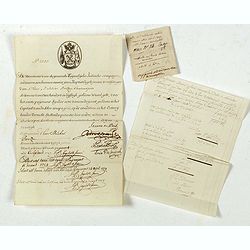
Very rare share in the Ostend Company.
Upper left hand corner share number 2305 in manuscript. In top emblem of the Ostend Company in copper engraving. Text: De Directeurs van de generale Keijserlijche- Indisc...
Place & Date: Antwerp / Ostend, 1723
![[Europe, Eastern, Sarmatia, Ukraine]](/uploads/cache/33854-250x250.jpg)
[Europe, Eastern, Sarmatia, Ukraine]
Wood block printed map and one of earliest printed representation of Europe, Eastern, Sarmatia, Ukraine prepared L. Fries after Martin Waldseemüller.Based on the slightl...
Place & Date: Vienna, Trechsel, G., 1525 -1541
![.[Near east with Cyprus]](/uploads/cache/33857-250x250.jpg)
.[Near east with Cyprus]
Wood block printed map and one of earliest printed representation of Near east with Cyprus prepared by Martin Waldseemüller. Based on the slightly larger map from 1513 p...
Place & Date: Vienna, 1525 -1541
![.[India]](/uploads/cache/33861-250x250.jpg)
.[India]
Wood block printed map and one of earliest printed representation of India prepared by Martin Waldseemüller. Based on the slightly larger map from 1513 published in &quo...
Place & Date: Vienna, Trechsel, G., 1525 -1541
![.[Bangladesh, Burma, India, Thailand]](/uploads/cache/33867-250x250.jpg)
.[Bangladesh, Burma, India, Thailand]
Wood block printed map and one of earliest printed representation of Bangladesh, Burma, India, Thailand prepared Martin Waldseemüller. Based on the slightly larger map f...
Place & Date: Vienna, Trechsel, G., 1525 -1541
![.[Georgia (Republic), Sarmatia, Ukraine]](/uploads/cache/33870-250x250.jpg)
.[Georgia (Republic), Sarmatia, Ukraine]
Wood block printed map and one of earliest printed representation of Georgia (Republic), Sarmatia, Ukraine prepared by Martin Waldseemüller. Based on the slightly larger...
Place & Date: Vienna, Trechsel, G., 1525 -1541
![[India and China]](/uploads/cache/33875-250x250.jpg)
[India and China]
Wood block printed map and one of earliest printed representation of India and China prepared Martin Waldseemüller. Based on the slightly larger map from 1513 published ...
Place & Date: Vienna, 1525 -1541

Xantung, sinarum imperii provincia quatra.
A map of the northern province ‘Xantung’ of China after the Jesuit Martino Martini.Shows the Great Wall and is centered on the Bohai Sea, and the Shandong and Liaonin...
Place & Date: Amsterdam, ca 1660
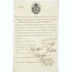
Very rare share in the Ostend Company. (299)
Upper left hand corner share number "299" in manuscript. In top emblem of the Company in copper engraving. Text: " De Directeurs van de generale Keijserlij...
Place & Date: Antwerp / Ostend, 1723

Novissima et Accuratissima Totius Americae Descriptio.
Second state of Visscher's map of the Americas, this decorative map greatly influenced the cartography of the Americas both geographically and artistically.Although it di...
Place & Date: Amsterdam, 1677

Imperii Sinarum nova descriptio.
Schenk and Valk's rare early 18th century issue of Janssonius milestone map of China, Korea and Japan after Martino Martini. Engraved by Johannes van Loon. The overall ba...
Place & Date: Amsterdam, ca. 1720
![Tabula electoratus Brandenburgici, Meckelenburgi, et maximae partis Pomeraniae, ex variis, famosissimisq[ue] auctoribus summo studio concinnata. . .](/uploads/cache/37545-250x250.jpg)
Tabula electoratus Brandenburgici, Meckelenburgi, et maximae partis Pomeraniae, ex variis, famosissimisq[ue] auctoribus summo studio concinnata. . .
Uncommon "carte à figures"- map engraved by the master engraver Abraham Goos and published by Claes Jansz. Visscher (1587-1652). Showing the part of western Po...
Place & Date: Amsterdam, 1630
![The Coast of New Found Land From Salmon Cove to Cape Bonavista. . . [together with] The Coast of New Found Land from Cape-Raze to Cape St-Francis.](/uploads/cache/40658-250x250.jpg)
The Coast of New Found Land From Salmon Cove to Cape Bonavista. . . [together with] The Coast of New Found Land from Cape-Raze to Cape St-Francis.
Two charts showing the coast of New Found Land from Salmon Cove to Cape Bonavista and from Cape-Raze to Cape St-Francis. With inset chart of Trinity HarborGrierson publis...
Place & Date: Dublin, 1767