Browse Listings
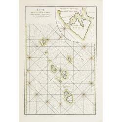
![[Haida Gwaii,] Baye Swallow . . . / Havre Byron /Côté septentrional de la plus grande des Isles de la Reine Charlotte. . . .](/uploads/cache/25888-250x250.jpg)
[Haida Gwaii,] Baye Swallow . . . / Havre Byron /Côté septentrional de la plus grande des Isles de la Reine Charlotte. . . .
Map of Swallow's Bay and a coastline profile of the Queen Charlotte Islands and Captain Byron's Heaven.Queen Charlotte Islands, with their modern name Haida Gwaii, is an ...
Date: Paris, 1774

A chart of the China Sea inscribed to Monsr. D'APRES de MANNEVILLETTE .. To A.Dalrymple.
This most important milestone chart is based upon the surveys made from navigational surveys by Alexander Dalrymple (1737-1808]. He was the first hydrographer of the Brit...
Date: Paris, ca 1775
Carte des Isles Nicobar... (with) Plan particulier du Port compris entre les Isles Nacaveri, Souri, et Tricutte.
French chart of Isles of Nicobar in Gulf of Bengal near Birmanie and Sumatra. Prepared by Jacques-François L'Abbé Dicquemare (1733-1789). Latitude and longitude scales,...
Date: Paris, Brest, chez Demonville, 1775
![Planisphere celeste Septentrional. . . [together with] Planisphere celeste meridional. . .](/uploads/cache/35291-250x250.jpg)
Planisphere celeste Septentrional. . . [together with] Planisphere celeste meridional. . .
Beautiful set of celestial charts of the northern and southern skies by the well-known French astronomer, Philippe de La Hire. Surrounded by panels of astronomical notes ...
Date: Paris, ca.1775
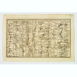
The Road from London to Barnstable, in Devonshire, commencing at Andover, in the road to the Lands End, also from Barnstable to Truro.
A highly detailed late eighteenth century road map, running left to right, commencing at Andover in Hampshire and continuing on to Barnstable in north Devonshire. The map...
Date: London, 1775
![Schat-Kamer ofte konst der stuurlieden, behelzende een duidelyke onderwyzinge in de navigatie. . . [bound with] Tafelen bevattende De Sinussum, tangenten en Secanten. . . [bound with] Geographische Tadfel...](/uploads/cache/33112-250x250.jpg)
Schat-Kamer ofte konst der stuurlieden, behelzende een duidelyke onderwyzinge in de navigatie. . . [bound with] Tafelen bevattende De Sinussum, tangenten en Secanten. . . [bound with] Geographische Tadfel...
Schat-Kamer ofte konst der stuurlieden, behelzende een duidelyke onderwyzinge in de navigatie. . . [bound with] Tafelen bevattende De Sinussum, tangenten en Secanten. . ....
Date: Amsterdam, J. v. Keulen en Zoonen, 1777

A Map of the most Inhabited part of New England containing the Provinces of Massachusetts Bay and New Hampshire, with the Colonies of Connecticut and Rhode Island.
A copper engraving in four sheets, published in Georges Louis Le Rouge, in his "Atlas Ameriqua in Septentrional Contenant les details des differentes provinces, de c...
Date: Paris, 1777

A plan of the City and Environs of Philadelphia. . .
The Lotter edition of Scull & Heap's seminal Philadelphia map, which map was first issued in 1752.Holmes' grid plan for the city is shown, situated between the rivers...
Date: Augsburg, 1777

Carte nouvelle de l'Amérique angloise contenant tout ce que les Anglois possèdent. . . avec la Floride / gravée. . . par Maththias Albert Lotter. . .
As mentioned in the title piece, the map includes the area at that time in the possession of the English, i.e. Canada, New Large, beautiful and detailed map of the Easter...
Date: Augsburg, 1777
![[ Text / title page Charts of the coasts and harbours of New England . . .]](/uploads/cache/44832-250x250.jpg)
[ Text / title page Charts of the coasts and harbours of New England . . .]
Letterpress text page, taken from the "Atlantic Neptune".The Atlantic Neptune is universally recognised as one of the most magnificent atlases ever made.Example...
Date: London, 1777
![[Lower half] Amerique Septentrionale avec les Routes, Distances en miles, Limites et Etablissements François et Anglois Par le Docteur Mitchel Traduit de 'Anglois..](/uploads/cache/49378-250x250.jpg)
[Lower half] Amerique Septentrionale avec les Routes, Distances en miles, Limites et Etablissements François et Anglois Par le Docteur Mitchel Traduit de 'Anglois..
This is the important 1777 Georges Le Rouge French edition of the seminal John Mitchell map of the eastern part of North America. The Mitchell map is considered the singl...
Date: Paris, 1777

Ilse Paese de' Selvaggi.. Lago Superiore. (Florida and the Bahamas)
Antonio Zatta published an Italian version of the John Mitchell map in twelve sheet. This sheet depicts Lake Superior in the Bellin version, as it appeared on the Mitchel...
Date: Venice, 1778

Etats du Grand-Seigneur en Asie, empire de Perse, pays des Usbecs, Arabie et Egypte.
Detailed map of the region bounded by the Black Sea, Georgia, the Caspian, Uzbekistan, The Indian Ocean, Saudi Arabia (here called \"Arabie Heureuse\"), Egypt a...
Date: Venise, 1778

Carte Réduite Des Côtes Orientales De L' Amérique Septentrionale Contenant Partie du Nouveau Jersey.. Virginie.. Georgie..
Uncommon chart that extends from Delaware Bay and Philadelphia south through much of Georgia to Island Amelia and St. Johns River. Fleur-de-lis and rhumb lines fill the s...
Date: Paris, 1778

Africa juxta navigationes et observat recentissimas. . .
Miniature map of Africa, a reduction of the Seutter folio map based on Homann''s cartography of 1715. Very detailed - much of it fictitious. The Nile is shown not only or...
Date: Augsburg, J.M.Will, 1778
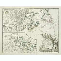
Partie de l'Amerique septent? Qui comprend la nouvelle France. . .
A fine copy of this map of New Foundland, Nova Scotia and the course of the St.Lawrence to Lake Ontario in a forth state.An inset shows Bellini's famous and important map...
Date: Paris, 1755-1778

A new & accurate map of Asia, Drawn from the most approved modern maps & charts / by Thos. Bowen.
The map is of interest for the use of Sea of Korea, the sea between Korea and Japan.Detailed map of Asia from Saudi Arabia, Persia, Russia, India, China, Japan to Southea...
Date: London, J.Cooke, 1777-1778
Selling price: ????
Please login to see price!
Sold in 2023

Mappa Geographica provinciae Nova Ebboraci ab Anglis NEW-YORK dictae. . .
During the Revolution, this map afforded British commanders an excellent overview of areas that would be crucial in the early years of the war, particularly the Hudson Va...
Date: Nuremberg, 1778

Mappa geographica Provinciæ Nova Eboraci ab Anglis New-York . . .
Lower part of the two sheets map of Homann Heirs' edition of Sauthier's celebrated map of New York and New Jersey, made during the Revolutionary War. Appears in Homann's ...
Date: Nuremburg, 1778
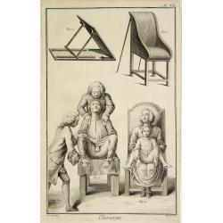
Chirurgie, plate XII
Showing medical chair and physician at work from the medical section of Diderot's Encyclopaedia. Engraved by Bernard after a design of Goussier. Very important work as it...
Date: Paris 1779

Carte des parties Nord et est de l'Asie..
Five maps on one sheet show the Northern Russian territories in Europe and Asia, including the western coastline from Siberia, Japan, and Korea with the island of "Q...
Date: Paris, 1779
![[Title page] Atlante Novissimo, Tomo I . . .](/uploads/cache/43898-250x250.jpg)
[Title page] Atlante Novissimo, Tomo I . . .
Decorative Venitian frontispiece from Antonio Zatta's "Atlante Novissimo tomo I".
Date: Venice, 1779

Gezicht van het Admiraliteits-Magazyn en Scheeps Timmerwerf.
Formerly the V.O.C. warehouse and arsenal for the Admiralty of Amsterdam, now-a-days the Scheepvaartmuseum (Maritime Museum). Taken from the "Atlas of Amsterdam"...
Date: Amsterdam, 1780

A Perspective View of the Admiralty Office, Dock-Yard, Storehouses &c. at Amsterdam.
Decorative engraving giving good detail of the intense activity in the Amsterdam dockyards.Engraved for BANKES's New System of Geography
Date: Amsterdam, 1780

Carte d'une Partie des Cotes de la Floride et de la Louisiane, Contenant le Cours du Mississipi...
A well engraved and highly detailed chart of part of the Gulf Coast, dated 1778 that was issued in Neptune americo-septentrionale. The chart covers the area between St. J...
Date: Paris, 1778-1780

Vue du Magazin de la Compagnie des Indes Orientales. . .
So-called optical print of the formerly the V.O.C. warehouse and arsenal for the Admiralty of Amsterdam, now-a-days the Scheepvaartmuseum (Maritime Museum).In the eightee...
Date: France, 1780

Madrid.
Extremely rare town-view of Madrid. Engraved by Francesco Ambrosi.With a second title in lower part "Madrid Ciudad Capital Del Reyno D'Espana y real corte de los rey...
Date: Bassano del Grappa, c.1780

Gezicht van het Oost-Indisch-Huys, op de binnen plaats te zien, tot Amsterdam.
Taken from the "Atlas of Amsterdam". Showing the inner square of the East Indian House of the V.O.C. in Amsterdam.A place for meeting, trading and storage of sp...
Date: Amsterdam, 1780

La Pologne Dressée sur ce qu'en ot donné Starovolsk, Beauplan, Hartnoch. . .
Large map of Poland, Lithuania, Belarus and part of Ukraine. The map is filled with detail and decorated with a title cartouche flanked by mythological figures.According ...
Date: Paris, 1773 - 1780

Vue perspective de l'interieur de la Salle du spectacle de Veronne en Italie.
Showing the Opera of Verona. Optical print published Mondhare, who was a well-known publisher of optical prints, established in rue St. Jacques in Paris. In the eighteent...
Date: Paris, ca. 1780
![Une Kirguisiene par devant. [together with] Une Kirguisienne par derriere.](/uploads/cache/32991-250x250.jpg)
Une Kirguisiene par devant. [together with] Une Kirguisienne par derriere.
Uncommon copper-engraved costume plate showing two natives of Kyrgyzstan, a Central Asian country along the Silk Road, the ancient trade route between China and the Medit...
Date: St. Petersbourg, C.G. Müller, 1776-1780
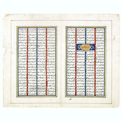
Double page manuscript page with Islamic prayers with beautiful headings throughout.
Fine double page brilliantly illuminated gilt leaves written by the scribe Abu Bakr Jami in Isfahan. The Arabic text contains Islamic prayers with beautiful headings thro...
Date: Isfahan, ca. 1780
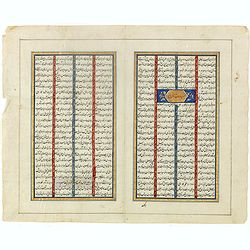
Double page manuscript page from a Shahnameh, The Book of Kings, written by Ferdowsi.
Fine double page brilliantly illuminated gilt leaves written by the scribe Abu Bakr Jami in Isfahan. The Arabic text contains Islamic prayers with beautiful headings thro...
Date: Isfahan, ca. 1780
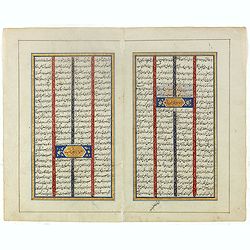
Double page manuscript page from a Shahnameh, The Book of Kings, written by Ferdowsi.
Fine double page brilliantly illuminated gilt leaves written by the scribe Abu Bakr Jami in Isfahan. The Arabic text contains Islamic prayers with beautiful headings thro...
Date: Isfahan, ca. 1780
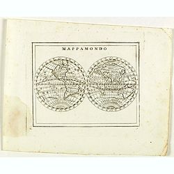
Mappamondo.
Rare world map from "Atlante Novissimo ad uso Dei Giovani Studiosi Contenuto In Carte XXVII.", published by Giovanni Zempel in Rome, ca. 1780.The map is based o...
Date: Rome, 1780
L'Italia Settentrionale presa da quella del Sig. Zannoni.
Rare map of Italy with inset map with Corsica and Sardinia, from "Atlante Novissimo ad uso Dei Giovani Studiosi Contenuto In Carte XXVII.", published by Giovann...
Date: Rome, 1780
![Ch'onha chido. [Atlas of all under Heaven]](/uploads/cache/44640-250x250.jpg)
Ch'onha chido. [Atlas of all under Heaven]
A late 18th-century Ch'onha chido atlas with 10 woodblock maps showing the World, China, and the 8 province maps of Korea (Hamgyeong, Gangwon, Jeolla, Gyeongsang, Pyeonga...
Date: Korea, ca. 1780
![[No title.] Sixteen small engravings.](/uploads/cache/46799-250x250.jpg)
[No title.] Sixteen small engravings.
A nice set of sixteen French professions, or trades, or stage characters. The print is faint on some titles. Some of the characters are a soldier, a doctor, a nun, a lawy...
Date: Paris, ca. 1780
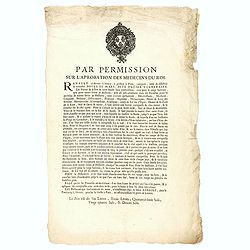
Par permission sur l'aprobation des médecins du roi...la véritable Boule de Mars...
Printed broadsheet promoting the "Boule de Mars" (March Ball) produced and sold by Renault in Nancy and Paris. Ornated with the royal coat of arms of France. Pr...
Date: Paris, ca.. 1780

Connecticut and Parts adjacent at Amsterdam. .
A nice example of this early map of the state of Connecticut with part of Rhode Island to the east, Long Island to the south, and New York to the east. Rivers, roads, t...
Date: Amsterdam, 1780
![[Lot of 4 charts] Plan de la Baie et du Port de Camraigne / Plan de la Baie de Niatrang et du Golfe de Binkang / Plan de la Cote de Cochinchine. . . / Plan des Ports de Xuandai, Vung-Lam. . .](/uploads/cache/44795A-250x250.jpg)
[Lot of 4 charts] Plan de la Baie et du Port de Camraigne / Plan de la Baie de Niatrang et du Golfe de Binkang / Plan de la Cote de Cochinchine. . . / Plan des Ports de Xuandai, Vung-Lam. . .
[A set of four French sea charts numbered consecutively]. A set of 4 basic coastal sea charts of parts of southern French Indochina (Vietnam).Chart 295 centers on the reg...
Date: Paris ca 1780
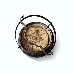
Inverted nautical Compass, called "mouchard" (~ "spy")
Inverted maritime compass called "mouchard" (spy) in wood and brass, signed "A Van Vastenhoud In Amsterdam". This type of compass was found in the cap...
Date: Amsterdam, ca. 1780
Orvis veteribus novi tabula nova. . .
Scarce map of the Ancient world, prepared by Nolin and published by L.J. Mondhare for his Atlas Général a l'usage des colleges et maisons d'education.. Louis Joseph Mon...
Date: Paris, 1781

Plan de la ville de Maestricht avec ses attaques commandées par M. le maréchal de Saxe, depuis le 15 avril jusqu'au 3 may 1748 . . .
A plan of Maastricht rising after the capture of the city by the French troops led by the Marshal of Saxony. The city was besieged between 15 April and 3 May 1748, during...
Date: Paris, 1781
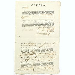
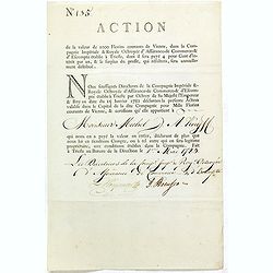
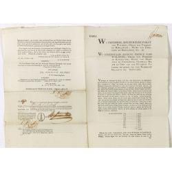
ACTION N° 1155. Société du Commerce d'Asie & d'Afrique.
Share of 1 000 Florins d'Allemagne (1 000 Guilder) of the "Triester Handelsgesellschaft" (Société du Commerce d'Asie & d'Afrique) signed by duke Charles d...
Date: Triest / Antwerpen, 1 October 1781
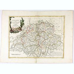
Parte Orientale dell'Elvezia divisa ne'suoi Cantoni di nuova projezione.
Antonio Zatta's detailed map of the eastern part of the Confederation of Switzerland divided into its Cantons. Shows political and administrative boundaries, cities, town...
Date: Venice, 1781
L'Elvezia divisa ne suoi Tredici Cantoni e suoi Alleati di nuova projezione.
Antonio Zatta's detailed map of the Confederation of Switzerland divided into its thirteen Cantons and their allies. Shows political and administrative boundaries, cities...
Date: Venice, 1781

MARS Rejouissances du Papeguay. Les Triomphes d'un conquerant
Etching published by Louis Charles Desnos (1725-1805) with address of rue St.Jacques au Globe. He is also known for his output of wall maps and atlases.
Date: Paris, 1782
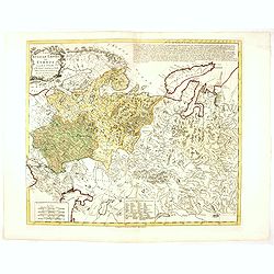
Russian Empire in Europe from the Dr. D'Anville of the Royal Academy. . .
Rare map of Russia, prepared by John Bayly (active 1755-1794) after D'Anville. In the lower-left corner parts of the Caspian and Black Sea. In the upper right corner Nova...
Date: London, ca. 1782

Carte Geo-Hydrographique du Golfe du Mexique et de ses Isles..
Map of the Caribbean and Gulf of Mexico showing the various islands and continental coastlines according to the 18th century Venetian cartography of Rizzi Zannoni.Illustr...
Date: Paris, ca 1783

Carte du Mexique et des Etats Unis d'Amérique...
A later edition of De l'Isle's foundation map of 1703, is widely regarded as one of the most influential maps in the history of American Cartography. This updated version...
Date: Paris, 1783
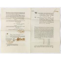
Share of 1000 Florins to Michel de Knyff. N° 135.
Share of 1000 Florins, paid in four tranches at 250 Florins of Vienna, from "Compagnie Imperiale & Royale Octroyee d'Assurance de Commerce & d'escompte."...
Date: Trieste, 1782 - 1783
![[Title page for] Recueil de cartes sur la geographie ancienne . . .](/uploads/cache/47729-250x250.jpg)
[Title page for] Recueil de cartes sur la geographie ancienne . . .
Title-frontispiece of "Recueil de cartes sur la geographie ancienne", published by Rigobert Bonne in 1783, engraved by Louis Legrand.More about title pages [+]
Date: Paris, 1783
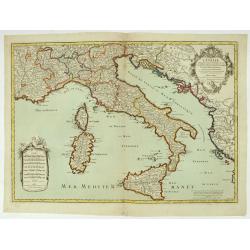
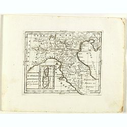
L'Italie distinguée suivant l'estendue de tous les Estats, Royaumes, républiques, Duchés, Principautés, &c.
Decorative map of Italy including Corsica, Sardinia and Sicily engraved by Cordier and published by Desnos. A text at lower right refers to the earthquake of Messine in 1...
Date: Paris, Desnos, 1783
Selling price: ????
Please login to see price!
Sold in 2026

Nouvelle Mappa Monde.
State 2 of this fine double hemisphere world map, from an unusual perspective, with a "Mer de L'Ouest" or "Sea of the West". Paris is located at the c...
Date: Venice, 1776 - 1784
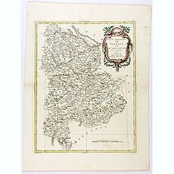
![[2 maps] Partie Septentrionale.. Partie Meridionale du Royaume de Portugal..](/uploads/cache/25084-250x250.jpg)
[2 maps] Partie Septentrionale.. Partie Meridionale du Royaume de Portugal..
A detailed two sheet map of Portugal showing the roads, prepared by N.Bellin. Venetian edition of the map by Bellin, to whom Santini gives credit in the cartouche.From ...
Date: Venice, 1776 - 1784
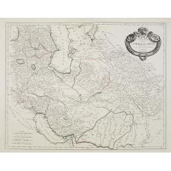
Carte de l'Empire de Perse. . .
Map of the Persian empire by the Venetian cartographer and publisher François (Père) Santini and first published in Santini's 'Atlas Universel dressée sur les meuilleu...
Date: Venice, 1784

La Tartaria Chinese.
With decorative title cartouche. Covering north eastern part of China, with good detail in Korea and a curious shape for Hokkaido (here called Jeso-Gasima ).Engraved by G...
Date: Venice, 1784

La Tartaria Chinese.
With decorative title cartouche. Covering north eastern part of China, Korea and Hokkaido (here called Jeso-Gasima, Tartary including the Gobi Desert; also Peking and the...
Date: Venice, 1784

Campagne du Roi de Prusse de 1778 à 1779.
The book is illustrated with a two-sheet folding map "Carte d'une partie du Royaume de Bohême et de la Moravie ainsi que d'une partie de la Silésie". Prepared...
Date: Geneva, Paris, Mérigot le jeune, 1784

Tablaeu de l'Univers premiere partie/ .. seconde partie.
Uncommon and interesting manual containing a double hemisphere world map (with fine outer decoration and showing an imagined great sea in West America, easily the size of...
Date: Luik, Belgium, 1784

M.Merian, l'Ancien célébre graveur . . .
Portrait of Matthäus Merian (1593-1650) by Hubert. Matthäus Merian der Ältere was a Swiss-born engraver who worked in Frankfurt for most of his career, where he also ...
Date: Paris, 1784

Carte D'Amerique Divisée en ses Principaux Pays. . .
Rare. Uncommon and decorative wall map of America, prepared by Clouet. With superb decorative borders, 170mm wide at the sides and 150mm at the bottom, containing twenty ...
Date: Paris, Cadiz, 1785

ETATS-UNIS DE L'AMÉRIQUE SEPTENTRIONALE Avec LES ISLES ROYALE, DE TERRE NEUVE, DE S.T JEAN, L'ACADIE, &c. 1785. Supplement a l'Atlas de M. Robert de Vaugondy a Paris Ches Boudet Ingenieur du Roi.
A map of the eastern United States with "Supplément à l'atlas de M. Robert de Vaugondy à Paris chez Boudet Imprimeur du Roi", in place of the attribution to ...
Date: Paris, 1785
![[Title page] Atlante Novissimo, illustrato ed accresciuto . . .](/uploads/cache/43897-250x250.jpg)
[Title page] Atlante Novissimo, illustrato ed accresciuto . . .
Decorative Venitian frontispiece from Antonio Zatta's Atlas Atlante Novissimo, illustrato ed accresciuto . . . . The outer decoration of this title page has a wealth of c...
Date: Venice, 1785

Mariner’s compass
Inverted compass called "snitch" in wood painted in imitation of tortoiseshell and brass, signed "Ing MANN Maker Water Street Liverpool".
Date: Liverpool, ca. 1785
Atlas in elephant folio.
Most of D'Anville's atlases were made up for the individual customer, so no two appear alike. Many of the 59 pages are multi-sheet maps, so the actual map sheet count is ...
Date: Paris, 1771-1786
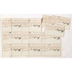
Coupon 94 voor een jaar interest voor f 1000 by hunne hoog vorstelyke doorluchtigheden de heere Frederik regeerende furst von Waldek. . .
9 Coupons for one year interest of 1000 florins being 50 florins payable on January 1796, 1797, 1798, 1799, 1800, 1801, 1802, 1803, 1804. For a loan made out by The Hague...
Date: The Hague / Amsterdam, 1786
Bond and 8 coupons # 93 against a one year interest of 1000 Dutch Florins by Frederik ruler of Waldeck.
Bond for 10 years against one year interest of 1000 florins being 50 florins payable on January 1795 until 1804. With 8 pay-out coupons for one year interest of 1000 flor...
Date: The Hague / Amsterdam, 1786
Bond # 86 against a one year interest of 1000 Dutch Florins by Frederik ruler of Waldeck.
Bond for 10 years against one year interest of 1000 florins being 50 florins payable on January 1795 until 1804. For a loan made out by the The Hague bankers Abraham and ...
Date: The Hague / Amsterdam, 1786
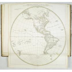
Mappemonde ou carte générale du globe terrestre dessinée suivant les règles de la projection des cartes réduites…
Large world map showing the sea tracks of Captain Cook in his three Pacific voyages published by C. F. Delamarche.Rare state 4, dated 1786, of this large world map, featu...
Date: Paris, Robert de Vaugondy/Delamarche, 1786
![[Crimea]. Carte de la Cromée.](/uploads/cache/25719-250x250.jpg)
[Crimea]. Carte de la Cromée.
Mapmaker, Captain Jan Hendrik van Kinsbergen (1735-1819). Published by H. Friesman in 1787. This map first appeared in 1776 and was the first Russian map of the newly ann...
Date: Amsterdam, H. Frieseman, 1787

Carte d'Asie divisée en ses principaux Etats.
Uncommon and decorative "carte à figures" - wall map, prepared by Clouet, with superb decoration, including a wonderful rococo border with 20 decorative vignet...
Date: Paris, Mondhare, 1787

Calendrier de la cour, tiré des éphémérides, pour l'Année bissextile.. / Notebook bearing silver plates with the VOC monogram.
A personal gift, only made for the trustees of the V.O.C. The silver plate was probably made by Drick van Hengel and Company because an entry in the diary of mintmaster J...
Date: Paris, 1787

Tableau des guerres de Frédéric le Grand: ou plans figurés de vingt-six batailles rangées, ou combats essentiels donnés dans les trois guerres de Silésie. . .
The book includes a large folded map "Tableaux des Guerres de Frédéric le Grand", showing a map of Prussia, with present-day Poland and Eastern Germany surrou...
Date: Potzdam, Strasbourg, Paris, 1788
![Matelot Hollandais [Dutch sailor]](/uploads/cache/28927-250x250.jpg)
Matelot Hollandais [Dutch sailor]
Etching showing a typical Dutch sailor, after Jacques Grasset de Saint-Sauveur (1757–1810). Taken from "Costumes Civils actuels de tous les peuples connus, dessin�...
Date: Paris, Pavard, 1788

Map of Louisiana from D'Anville's Atlas.
This map presents a highly detailed treatment of the region from Cabo Del Norte to the Apalachiola River, centered on the mouth of the Mississippi and extending inland to...
Date: London, 1788

Carte d'Europe divisée en ses Empires et Royaumes.
Uncommon and decorative wall map of Europe, prepared by Clouet. Superb decoration including a wonderful rococo border with vignettes describing historical scenes. Below t...
Date: Paris, Mondhare, 1788
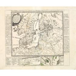
Neue Karte von den gegenwärtigen Kriegs-Schauplatze zwischen den Russisch-Kayserl.
Very rare separately published map showing the Russian War seat including Finland, Lithuania, Denmark and parts of Poland, Norway and Sweden. In lower part inset maps of ...
Date: Leipzig, 1788
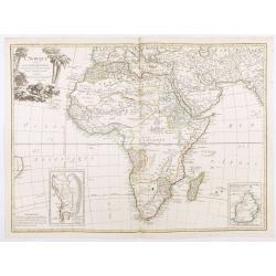
L'Afrique divisée en ses principaux Etats, assujettie aux observations astronomique.
Rare and attractive map of Africa, ornated with a decorative title cartouche showing luxuriant nature and a lion. With two inset maps : "Carte particulière du Cap ...
Date: Paris, Lattré, 1788

