Browse Listings
![[Title page] Atlante Novissimo, illustrato ed accresciuto . . .](/uploads/cache/43897-250x250.jpg)
[Title page] Atlante Novissimo, illustrato ed accresciuto . . .
Decorative Venitian frontispiece from Antonio Zatta's Atlas Atlante Novissimo, illustrato ed accresciuto . . . . The outer decoration of this title page has a wealth of c...
Place & Date: Venice, 1785
![[Title page] Atlante Novissimo, Tomo I . . .](/uploads/cache/43898-250x250.jpg)
[Title page] Atlante Novissimo, Tomo I . . .
Decorative Venitian frontispiece from Antonio Zatta's "Atlante Novissimo tomo I".
Place & Date: Venice, 1779
![[TAI travel poster]](/uploads/cache/44304-250x250.jpg)
[TAI travel poster]
A whimsical travel poster for "Transport Aeriens Intercontinentaux" (TAI), published in Paris in 1960, by Luc-Marie Bayle (1914-2000). The poster depicts a twin...
Place & Date: Paris, 1960

Fossa Sanctae Mariae.
Detailed map of part of the country between rivers Rhine and Meuse showing a canal to be dug between 1626 and 1628 between Rheinberg in Germany and Venlo. A deficiency of...
Place & Date: Amsterdam, 1645
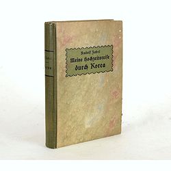
Meine Hochzeitsreise durch Korea während des Russisch-japanischen Krieges.
Illustrated with ca. 200 illustrations. All photographs are taken by the author.
Place & Date: Altenburg, S.-A., Stephan Geibel Verlag, 1906

Asiae Minoris nova descriptio. Geographische Beschryvinge aller Landen... ende sendbrieuen der Apostele...
Extremely rare map from a Dutch bible, published by Dancker Danckerts. This map was included in a Dutch bible including several maps signed by C.Danckerts and one dated 1...
Place & Date: Amsterdam, 1643

Calendrier de la cour, tiré des éphémérides, pour l'Année bissextile.. / Notebook bearing silver plates with the VOC monogram.
A personal gift, only made for the trustees of the V.O.C. The silver plate was probably made by Drick van Hengel and Company because an entry in the diary of mintmaster J...
Place & Date: Paris, 1787
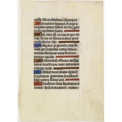
Leaf on vellum from a manuscript Book of Hours.
RECTO: Six 1-line initials in liquid gold on colored grounds and five line-fillers in same.VERSO: Five 1-line initials in liquid gold on colored grounds and one 2-lines i...
Place & Date: France, 1520-1550

Florentini Dominii Fidelissima et nova descriptio.
The map is centered on the city of Florence and extends to Liguria, the Apennine Mountains, the Adriatic Coast, Siena and Lago di Perugia. The map is based upon Stefano B...
Place & Date: Anvers, 1598
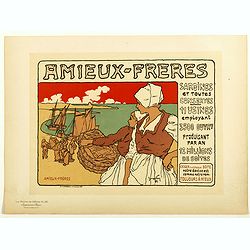
Amieux Freres, sardines et toute conserves.
Chromo lithographed poster of Les Maîtres de l'Affiche being plate n°183. The "Les Maîtres de l'Affiche" contained 256 small for lithographic prints of the b...
Place & Date: Paris, Imprimerie Chaix, 1899

Nova et Accuratissima Totius Terrarum Orbis Tabula.
Since its appearance as an Appendix in 1630, the atlas launched by Willem Blaeu and continued by his son Joan had expanded greatly. But despite many new regional maps the...
Place & Date: Amsterdam, 1662
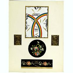
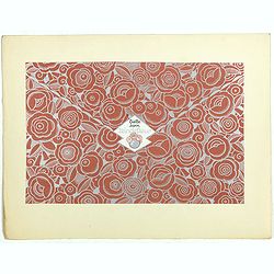
Five Art déco labels.
5 Lithographed perfume labels laid on original cardboard sheet. A striking example of commercial artworks produced by the artist and graphic designer Robert Pichon and hi...
Place & Date: Paris, between 1925 and 1930
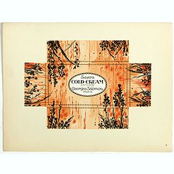
Art déco label for Georges Salomon Paris.
Lithographed perfume label "Savon Cold cream N°1531 - Georges Salomon Paris" laid on original cardboard sheet. A striking example of commercial artworks produc...
Place & Date: Paris, between 1925 and 1930
Art déco label Biette Savon - Tein de fleur.
Lithographed perfume label " Biette Savon - Tein de fleur" laid on original cardboard sheet. A striking example of commercial artworks produced by the artist an...
Place & Date: Paris, between 1925 and 1930
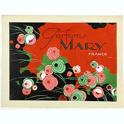
Art déco label for Parfum Mary France.
Lithographed perfume label "Parfum Mary France" laid on original cardboard sheet. A striking example of commercial artworks produced by the artist and graphic d...
Place & Date: Paris, between 1925 and 1930
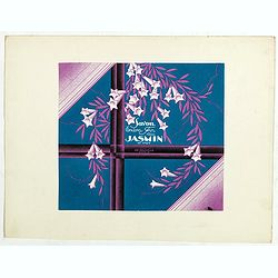
Art déco label for de Neuville, Paris.
Lithographed perfume label " Savon extra fin au jasmin N°1727 " laid on original cardboard sheet. A striking example of commercial artworks produced by the art...
Place & Date: Paris, between 1925 and 1930
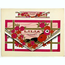
Art déco label Paul Tranoy, Paris.
Lithographed perfume label " Lilia Savon extra fin soap - Œillet (carnation) Paul Tranoy Paris N°725 " laid on original cardboard sheet. A striking example of...
Place & Date: Paris, between 1925 and 1930

A Map of the British Empire in AMERICA with the French, Spanish and Hollandish Settlements Adjacent Thereto. by Henry Popple. / Nouvelle Carte Particuliere de L'Amerique . . .
The four sheet Dutch edition of Popple's monumental map of North America, in mint condition. Encompassing the West Indies, Florida, Louisiana, Texas and Central America.T...
Place & Date: Amsterdam, ca. 1737
Tabula Russiae.
A re-issue, by Willem Blaeu, of Hessel Gerritsz' rare and influential map of Russia. This fine map was compiled from manuscripts brought back from Russia, by Isaac Massa ...
Place & Date: Amsterdam, 1650

Amsterdam Ville du Comté de Hollande et la plus considerable des Provinces Unies. . .
A very decorative and extremely rare town-view of Amsterdam, including a numbered (1-18) key in lower part. Extensive shipping on the IJ. To the left the headquarters of ...
Place & Date: Paris, ca.1750

Le Théâtre du monde dédié au roi contenant les cartes générales et particulières des royaumes et états qui le composent.
The present example of the Théâtre du monde is the reissue of 1746 by Jean-Baptiste Nolin II. This scarce atlas is illustrated with 123 maps mostly double-page, in orig...
Place & Date: Paris, 1746

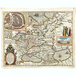
Chorographica descriptio provinciarum, et conventum fratrum minorum S. Francisci Capucinorum...
All maps are good and dark impressions. Several maps with slight foxing and browning, the folding map with 2 splits (top right part 10 cm and lower left part 6 cm into en...
Place & Date: Turin, 1649
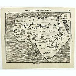
Africa Tertia pars Terrae.
This map of Africa has an unusual shape, tapering to a narrow angle in the south. Numerous rivers appear in West Africa and as tributaries to the Nile, and mountain chain...
Place & Date: Magdeburg, ca 1597
![[Il mondo a pezzi - Europa].](/uploads/cache/42849-250x250.jpg)
[Il mondo a pezzi - Europa].
Satirical representation of the division of the world by the main European powers. At the center of the scene a globe on which is written "MONDO Maledeto Interesse ...
Place & Date: Bologna, 1690

Carte d'unne partie de l'Arabie Septentrionale Pour suivre les Voyages de Mr. G.A. Vallin. . .
This is the original hand-drawn map by Victor Adolphe Malte-Brun of "Carte d'unne partie de l'Arabie Septentrionale Pour suivre les Voyages de Mr. G.A. Wallin",...
Place & Date: Paris, November 1855
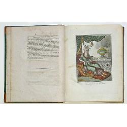
Encyclopedie des Voyages. Tom 3 ASIE.
There are in this volume as many as 89 color plates, all done by the author himself. Containing dresses of people of China, Persia, Armenia, Philippines, Java, India, Tar...
Place & Date: Paris, 1796

Vue et description des principales villes de l'Armenie et de la Georgie avec les habillements des femmes du pays, et ceux des prêtres et religieux armeniens. . .Tom: V N° 11 Pag: 28
View and description of the principal Armenian and Georgian cities with illustrations of Armenian women's garments as well as priests' and monks' clothing. The views are ...
Place & Date: Amsterdam, ca 1720
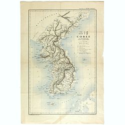
TYO SYEN Corée par les Missionnaires de Corée de la société des missions etrangéres.
A very nice map and rare map of Korea. Prepared by R.P.Carceri who was an missioner active for de la Sociéte des Missions Etrangères.Published as a supplement to Journa...
Place & Date: Lyon, 1872
Selling price: $700
Sold in 2023

Rare collection of costume plates.
Rare collection of costume plates published in Augsburg by the famous publishers Martin Engelbrecht, Ioh. Georg Hertel and the Jeremias Wolff Heirs.Composition :2 plates ...
Place & Date: Augsburg, ca. 1730

Carte des Isles du Japon Esquelles est remarque la Route..
This uncommon map of Japan, which is on a fairly large scale, contains comments about the nature of the country. For instance, Ocsaqui (Okazaki, near Nagoya) is said to h...
Place & Date: Paris 1679
![[ Hong Kong / Canton ] Nieuwe Pas=Caart strekkende van Pta Cataon tot Pta. Lamtoan, langs de kusten van Cochinchina, Tonquin, Quangsi en Quantung [?] van Macao.](/uploads/cache/24951-250x250.jpg)
[ Hong Kong / Canton ] Nieuwe Pas=Caart strekkende van Pta Cataon tot Pta. Lamtoan, langs de kusten van Cochinchina, Tonquin, Quangsi en Quantung [?] van Macao.
A finely engraved and detailed chart of Vietnam reaching to Macao and present-day Hong Kong..Very rare: only included in the 6th volume (so-called secret atlas) of Van Ke...
Place & Date: Amsterdam, 1753

Tabula nova Poloniae et Silesiae.
Second state, dated 1630 underneath the title. A finely engraved carte á figures with cartouche representing in the four corners of the map : Kings ( on the left side Si...
Place & Date: Amsterdam, 1630

Arabia. Sive Regio inter Mare Medium, Arabicum Sinum, . . .
Very detailed map of the Arabian Peninsular, covering the Caspian Sea in the upper right corner and Syria to the Indian Ocean, Somalia and parts of Persia, Syria and Kurd...
Place & Date: London, 1841

Arabia.
Steel engraved map of the Arabian Peninsular. It shows Arabia and Parts of Persia, Syria and Kurdistan. The regional boundaries are colored and relief shown by hachures. ...
Place & Date: London, 1841
![[West Central London from Booth's Poverty Map of London]](/uploads/cache/40267-250x250.jpg)
[West Central London from Booth's Poverty Map of London]
A map of West Central London, one section (of twenty) of an extended version of the incredibly influential Poverty Map, originally published in Charles Booth's 'Life and ...
Place & Date: London, 1900

Belgii novi, angliae novae, et partis Virginiae . . .
This example is state 3 of the original Janssonius plate, printed after Schenk acquired the plates at public auction in 1694 from the heirs of Jansson van Waesberge. The ...
Place & Date: Amsterdam, 1694
![Lutece conquise par les François sur les Romains ou second plan de la ville de Paris [...] par M.L.C.D.L.M.](/uploads/cache/42141-250x250.jpg)
Lutece conquise par les François sur les Romains ou second plan de la ville de Paris [...] par M.L.C.D.L.M.
Engraved plan of Paris, published in "Traité de la police de Nicolas de Lamare". Oriented to the North with a compass rose and equipped with a double scale (40...
Place & Date: Paris, 1729

Asia carta di ciasete piu moderna. (Japan)
Rare FIRST STATE of this important map for Korea and Japan map of the Blancus/Moreira type, but adds a huge 'Jesso' filling the top of this old map. The map is of interes...
Place & Date: Florence, 1646-1647
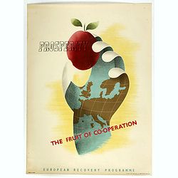
Prosperity - The Fruit of Cooperation.
NATO poster for European Cooperation by Brian E. Dear. On the poster the slogan "Prosperity the fruit of cooperation". The poster is showing a hand holding an a...
Place & Date: Kühn & Zoon Rotterdam, 1950
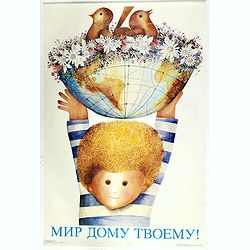
Protect the globe!, 1989.
USSR propaganda poster, with the slogan "protect de globe". A child holding a globe with flowers and birds.
Place & Date: Russia, 1989

COLLECTION OF HONG KONG MAPS, BOOKS & FLYERS. Including CHINA - HONGKONG surveyed by Captn. Sir Edward Belcher, in H.M.S. Sulphur 1841. Corrected to 1901.
A collection of 30 maps, prints, and publications relating to Hong Kong. Including : - BELCHER, E. Sir, An updated version of this most important nautical chart of Hong K...
Place & Date: London, 1841 - 1901

Peregrinationis Divi Pauli Typus corographicus. . .
A splendid map depicting the travels of Paulus. With two fine scenes in top. Showing the countries along the Mediterranean, including Cyprus and Italy. A first edition wi...
Place & Date: Antwerp, 1595
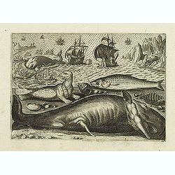
Virulus marinus. Cete (Whale and whaling scene)
Whale and whaling scene, set against a mountainous landscape in the manner of Pieter Brueghel the Elder. Plate number 1. The engraving is copied after Adrian Collaert pla...
Place & Date: Antwerp, after 1598

Typus Frisiae Orientalis à Dullarto
One of the most decorative maps of East Frisia and its important shipping center of Emden and the Watten Islands, from the cartography of Ubbo Emmius, a local cartographe...
Place & Date: Amsterdam, ca. 1624

Sumatra Insula.
A miniature map of Sumatra and the Malay Peninsula, including Singapore and the various islands directly south of it. Containing detailed geography and nomenclature aroun...
Place & Date: Amsterdam, 1609

Magnus Ducatus Finlandiae Auct. Andrea Bureo Succo.
The first printed survey map of Finland, composed by the Swedish cartographer Anders Bureus (1571-1661). The map was published in 1662 in the second volume of Joan Blaeu'...
Place & Date: Amsterdam, 1660

Karte von den Kusten von Arabien . . .
Manuscript map of Arabia. A close copy of Bellin's map of the Arabian Peninsula. In the lower right margin "Tom A, vol V."A title cartouche in the lower left co...
Place & Date: Germany, ca. 1760
![[Arabia]](/uploads/cache/40143-250x250.jpg)
[Arabia]
A lovely miniature map of the region of Armenia and Georgia, showing both parts of the Black Sea and Caspian Sea. For such a small map it renders a wealth of detail, with...
Place & Date: Ulm, 1692

Rowntree's Elect Cocoa.
Chromo lithographed poster of Les Maîtres de l'Affiche being plate n°168. The "Les Maîtres de l'Affiche" contained 256 small for lithographic prints of the b...
Place & Date: Paris, Imprimerie Chaix, 1899

India Tercera Nuova Tavola.
The 1598 edition of this early map of South East Asia. Just to the west and south of Malacca one will notice ‘Camatra’ (Sumatra) and Java. China with Canton in the up...
Place & Date: Venice, 1598
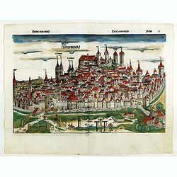
Nuremberga. Folio C.
Double page panoramic view of Nuremberg. Lettered above the view: "NVREMBERGA"; and with the names of the city's two most famous churches, S. Lorenz and S. Seba...
Place & Date: Nuremberg, 12 July 1493
Selling price: $1500
Sold in 2023

(EUROPE).
A woodcut colored map of northern and central Europe. The first modern map of the area. Second printed map of the North, after the woodcut map published in the 'Ulm' Ptol...
Place & Date: Nuremberg, 1493
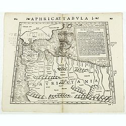
Aphricae Tabula I. (Mauritania - present-day Morocco, Algeria, and Tunisia.)
Double-page woodcut Ptolemaic-style map by Sebastian Münster figuring Mauritania, present-day Morocco, Algeria, and Tunisia, published in the edition of Strabo by Henri ...
Place & Date: Basle, Henri Petri, 1571

Le temple de la Mecque avec une description de tout ce qu'on y voit . . .
Fascinating engraving depicting the Muslim Kaaba at Mecca. Below the main image are two smaller vignette images of people praying. In between the two vignettes is a key (...
Place & Date: Amsterdam, 1728

Universe Europae Maritime Eiusque Navigationis Descriptio. Generale Pascaerte van Europa . . .
This general chart of north-western Europe and the surrounding coastal waters is from the rare pilot-guide De Spiegel der Zeevaerdt , printed by Christopher Plantin in Le...
Place & Date: Leyden, 1584

Driving chart of Hartford and vicinity : 15 miles around.
Road map by Albert A. Hyde & Co. of Hartford and vicinity, with the Connecticut River in the center. Published by Albert A. Hyde & Co., in New York and lithograph...
Place & Date: New York / Philadelphia, 1884

Coast to Coast.
A game board that features a map of the U.S. with a built-in spinner. Players travel a circular track around the map visiting landmarks as they go. A fun way to learn geo...
Place & Date: New York, ca. 1950
![[Russian Agitprop propaganda poster for 9 May]](/uploads/cache/42073-250x250.jpg)
[Russian Agitprop propaganda poster for 9 May]
Soviet propaganda poster celebrating Victory Day (Thursday 9 May). Showing a star with USA, English, French flags partly overlapped with Soviet flag and inscription in Ru...
Place & Date: Moskow, 1988
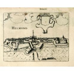
Helmond.
A panoramic view of the Helmond, seen from the Kromme Steenweg .
Place & Date: Arnhem, 1613

San Diego Bay. (Chart 5107)
Nautical chart of San Diego Bay of 1945. Printed in black, yellow and purple the "Seaward limit defensive sea area". The water area within the indicated limits ...
Place & Date: Washington, 1945

Large 13-person library (from Huxian Farmers' painting Exhibition)
A library with students with a western world map at the wall. Published by Shanghai renmin chubanshe (上海人民出...
Place & Date: Shanghai, September, 1974 / Janury 1975
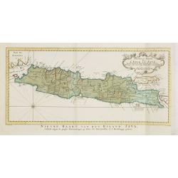
Nouvelle carte de l'Isle de Java.
A very nice map centred on the island of Java.With French text in title cartouche and an additional title in Dutch underneath the map.Read more Early maps of South East A...
Place & Date: Amsterdam, 1773

Nader prolongatie van het Octroy voor de Westindische Compagnie voor den tyd van nog dertig jaaren. . .
A proclamation by the Dutch States General, dated 1761, extending the charter of the Dutch West India Company for another thirty years. Like the 1730 proclamation, it has...
Place & Date: Amsterdam, 1761

Iava Maior.
Very fine miniature map of Java, engraved by Benjamin Wright (1575-1613). This early map contains detailed geography and nomenclature around the northern coastline of the...
Place & Date: Amsterdam, Cornelis Claes, 1606

The Kingdome of China.
A most sought-after map of China. Decorative border vignettes including views of the cities of Quinzay and Macao along the top border with the wheeled wind machines and p...
Place & Date: London, G. Humble, 1627

China Veteribus Sinarum Regio.
Based on Jesuit surveys, the map represents the next major revision in the cartography of China after Ortelius' 1584 map. Korea, however, is still an island, and Japan co...
Place & Date: Amsterdam, 1640

Le Isole di Sandwich delineate sulle osservazioni del Cap Cook.
FIRST EDITION on laid paper. Cassini’s splendid map depicts Sandwich islands, old name for Hawaii islands, at the end of the eighteenth century. The splendid cartouche ...
Place & Date: Rome, 1798

Limburgensis Ducatus Tabula Nova.
Map of Limburg, prepared by the Antwerp expert in law and mathematics Aegidius Martini. After 1600 Jan Baptist Vrients acquired the stock and the plates of Ortelius' Thea...
Place & Date: Antwerp, 1606-1612
![ISLA DE CUBA [with 2 maps] Plano Pintoresco De La Habana con los numeros de las casas B. May y Ca. 1853. (with) Inset map Puerto y Cereanias De La Habana. (with) 14 views of Havana & prominent buildings.](/uploads/cache/36720-250x250.jpg)
ISLA DE CUBA [with 2 maps] Plano Pintoresco De La Habana con los numeros de las casas B. May y Ca. 1853. (with) Inset map Puerto y Cereanias De La Habana. (with) 14 views of Havana & prominent buildings.
Lithographic town-plan surrounded with views of the city of Havana including the "Fuente De La India En El Paseo De Isabel 2a." and "Vista Gral De La Haban...
Place & Date: Havana, 1853

Nova Totius Terrarum Orbis Geographica ac Hydrographica Tabula.
A beautifully decorative world map taken from the 'English Atlas' by Moses Pitt and Steven Swart, based on an earlier engraved world map by Pieter van den Keere ca. 1630,...
Place & Date: Oxford, 1680

Colossus Monarchic. Statua Danielis
Fantastic double page allegorical map of a colossus figure representing the great world empires as Daniel interpreted in Nebuchadnezzar's dream. The warrior stands stolid...
Place & Date: Augsbourg, 1730

Hassia Landgraviatus.
Centered on the town of Kassel.
Place & Date: Amsterdam, 1650

Carte particulière des environs de St Peters-bourg. . . / Plan de la ville faubourg et environs de St Petersbourg. . . / Carte pour l'intelligence de la guerre de Moscovie et de Suede. . .
A scarce and unusual plan of Saint Petersburg shown at a large scale and also, in a separate compartment, shown in its geographical context between the Gulf of Finland an...
Place & Date: Paris, c.1741

Nuevo plano de la ciudad de Buenos Aires y parte del partido de avellaneda . . .
A rare detailed city plan of Buenos Aires prepared in 1912 by Ernesto Escalante. The plan depicts the city from the Partido de Avellaneda and the Villa Riachuelo to the R...
Place & Date: Buenos Aires, 1912

CARTE de la Côte Occidentale de COREE, Plan Croquis de la Rivière HAN-KANG ou de SEOUL, depuis son Embouchure jusqu'à Séoul, dressée en 1866 ...
Uncommon chart of the Han-Kang River from its mouth to Seoul, prepared in 1866 by order of C.A. ROZE, Commander-in-Chief of the French " la Station des Mers de Chine...
Place & Date: Paris, 1868

Grès Emile Muller . . .
Chromo lithographed poster, "Grès Emile Muller . . .", by CHARPENTIER, A. Plate 131, published in Maître 17, on April 1898. The "Les Maîtres de l'Affich...
Place & Date: Paris, Imprimerie Chaix, April 1898
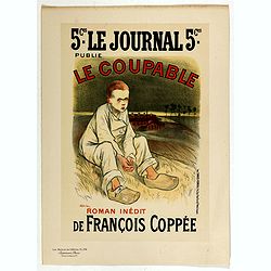
Le Coupable.
Chromo lithographed poster, "Le Coupable.", by STEILEN, A. Plate 134, published in Maître 17, on April 1896. The "Les Maîtres de l'Affiche" containe...
Place & Date: Paris, Imprimerie Chaix, April 1896
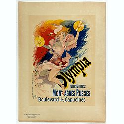
Olympia anciennes montagnes Russes.
Chromo lithographed poster, "Olympia anciennes montagnes Russes.", by CHERET, J. Plate 133, published in Maître 17, on April 1898. The "Les Maîtres de l'...
Place & Date: Paris, Imprimerie Chaix, April 1898
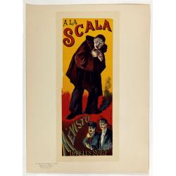
A la Scala, Mevisto.
Chromo lithographed poster, "A la Scala, Mevisto.", by LUCE, M. Plate 139, published in Maître 17, on April 1898. The "Les Maîtres de l'Affiche" con...
Place & Date: Paris, Imprimerie Chaix, April 1898
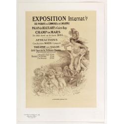
Exposition Internationale des produits du commerce . . .
Chromo lithographed poster, "Exposition Internationale des produits du commerce . . .", by WILETTE, A. Plate 142, published in Maître 17, on April 1896. The &q...
Place & Date: Paris, Imprimerie Chaix, April 1896