Browse Listings in Europe > Switzerland > Swiss Cantons

VII. Das Ergow.
Very early wood cut printed regional map of Switzerland centered on Ergow.Originally engraved in 1548. The map was prepared by Johannes Stumpf (1500-1576). Included in &q...
Date: Zurich, Christoffel Froschover, 1548,1552-1566

IX. Die Lepontier.
Very early wood cut printed regional map of Switzerland.Originally engraved in 1548. The map was prepared by Johannes Stumpf (1500-1576). Included in "Landtaflen. Hi...
Date: Zurich, Christoffel Froschover, 1548,1552-1566
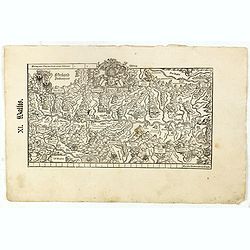
XI. Wallis.
Very early wood cut printed regional map of Switzerland with Wallis region.Originally engraved in 1548. The map was prepared by Johannes Stumpf (1500-1576). Included in &...
Date: Zurich, Christoffel Froschover, 1548,1552-1566

XII. Laurater Basler gelegenheit.
Very early wood cut printed regional map of Switzerland with Basel region.Originally engraved in 1548. The map was prepared by Johannes Stumpf (1500-1576). Included in &q...
Date: Zurich, Christoffel Froschover, 1548,1552-1566
![[Map of river Rhine.]](/uploads/cache/47453-250x250.jpg)
[Map of river Rhine.]
Map of the River Rhine from Boden See until Wesel. Left hand part of a 2-sheet map.
Date: Amsterdam, 1660
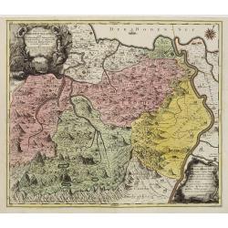
Pagus Helvetiae Abbatiscellanus .. Valle Rhenana. . .
Scarce. A splendid map of the Swiss Alps, the area south west of the Boden See and west of the River Rhine, centered on Appenzell, St. Gallen. Engraved by Tobias C. Lotte...
Date: Augsbourg, 1760
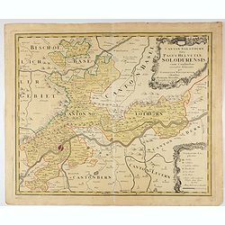
Canton Solothurn sive pagus Helvetiae Solodurensis cum confinibus recenter delineatus per Gabrielem Walserum.
A nice map of Swiss canton centered on Solothurn. Engraved by Tobias C. Lotter.
Date: Augsbourg, 1766
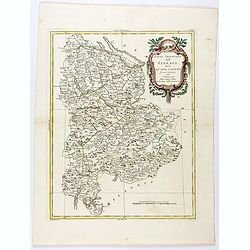
Parte Orientale dell'Elvezia divisa ne'suoi Cantoni di nuova projezione.
Antonio Zatta's detailed map of the eastern part of the Confederation of Switzerland divided into its Cantons. Shows political and administrative boundaries, cities, town...
Date: Venice, 1781
