Browse Listings in Europe

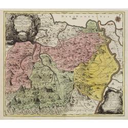
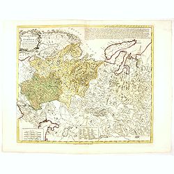
La Saxe Contenant le Routes et les postes. . .
Fine post-route map of Saxony in Germany with a splendidly engraved title cartouche. The map is centered on Leipzig. George Louis Le Rouge was active between 1740 and 178...
Date: Paris, 1756
Selling price: ????
Please login to see price!
Sold in 2025
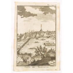
Citta di Varsavia.
Fine city view engraving of Warsaw, Poland by Thomas Salmon. Published in Rome by Giambattista Albrizzi in 1740. Giambattita Albrizzi was a famous Venetian publisher and ...
Date: Venice, 1740-1756
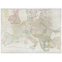
L'Europe divisée en tous ses états, dressée sur les nouveaux mémoires et suivant les dernières observations.
Rare wall map of the European continent, published by the Parisian publisher Sébastien G. Longchamp.The map is surrounded by a magnificent Rococo-style frame decorated w...
Date: Paris, 1757
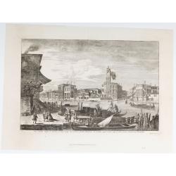
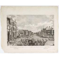
Pars Canalis Magni De Extendens A Laeva…
The Cannaregio on the Grand Canal, with the Ghetto in the background, seen from the Riva di Biasio. From the series "Magnificentiores Selectioresque Urbis Venetiarum...
Date: Venice, after 1757
Borussiae Regnum compectens Circulos Sambiensem, Natangiensem, et Hockerlandiae Nee non Borussia Polonica, exhibens Palatinatus Culmiensem. . .
Decorative map covering northern Poland with Prussia, Pomerania, Hockerlandia, Warmiaermelandia, Natanglensis, Galindia, Nandrovia, Sclavonia, and the Baltic Sea. Include...
Date: Augsburg, 1759

Vue Interieure de la Bourse Royale à Londres.
So-called optical print of the London stock exchange. Daumont was a well-known publisher of optical prints, established in Paris. In the eighteenth and nineteenth centuri...
Date: Paris, 1760

Vuë de l'ancien Palais d'hiver de sa Majesté Imperiale et du Canal qui Joint la Moika avec la Neva, a St. Petersburg.
So-called optical print illustrating a perspective view of St. Petersburg, namely the ancient Winter Palace and the canal which joins the Moika to the Neva.In the eightee...
Date: Paris, 1760

Belgica Foederata. . .
Decorated with a cartouche showing the coats of arms of Zeeland, Holland, Utrecht, Friesland, Groningen and Overijssel. T.C. Lotter married M. Seutter's daughter in 1740 ...
Date: Augsburg, ca.1760

6e Vüe d'Optique Représentant Le Chœur de la Cathedrale de St. Paul de Londres.
So-called optical print illustrating a perspective view of the interior of the Saint Paul Cathedral in London.In the eighteenth and nineteenth centuries there were many p...
Date: Paris, 1760

5e Vue d'Optique Representant La Vue interieure de la Cathedralle de St. Paul de Londres.
So-called optical print illustrating a perspective view of the interior of the Saint Paul cathedral in London. Engraved by la Marcade.In the eighteenth and nineteenth cen...
Date: Paris, 1760

39e Vüe d'Optique Representant L'Hotel du Lord Maire de Londre.
So-called optical print illustrating a perspective view of Somerset House on the Strand in London.In the eighteenth and nineteenth centuries there were many popular speci...
Date: Paris, 1760

26e Vüe d'Optique Representant L'Abbaye de Westminster et de l'Eglise Ste. Marguerite à Londres.
So-called optical print illustrating a perspective view of the Westminster Abbey, in London.In the eighteenth and nineteenth centuries there were many popular speciality ...
Date: Paris, 1760

Vuë du dedans de l'Eglise de St. MARTIN à Londre.
So-called optical print illustrating a perspective view of the central aisle of St. Martin's church, in London.In the eighteenth and nineteenth centuries there were many ...
Date: Paris, 1760

Vüe Perspective du Pont neuf construit sur la tamise a Hampton-Court.
So-called optical print illustrating a bridge on the river Thames at Hampton-Court.In the eighteenth and nineteenth centuries there were many popular speciality establish...
Date: Paris, 1760
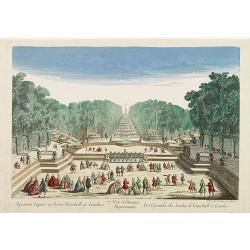
77e Vüe d'Optique Représentant Les Cascades du Jardin de Vauxhall a Londres.
So-called optical print illustrating a perspective view of the fountains and artificial cascades in Vauxhall Gardens, London.In the eighteenth and nineteenth centuries th...
Date: Paris, 1760

A view of Amsterdam taken from the Old Rampart.
So-called optical print of Amsterdam, published by Jean Mondhare after a print by Laurie and Wtitle. With captions in English and French above and belowIn the eighteenth ...
Date: Paris, ca. 1760
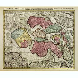
Zeelandiae Comitatus. . .
Scarce map of Zeeland, this is the state published by Tobias Conrad Lotter, previously published by Matthäus Seutter.Impressive cartouche with coat of arms of Zeeland to...
Date: Augsburg, c.1760
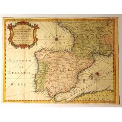
A New and Accurate Map of the Kingdoms of Spain, Portugal and Part of France, The Islands of Majorca, Minorca &c.
Produced for “Universal Magazine” by J. Hinton. It was engraved by Richard William Seale (1703-1762). The map features an attractive rococo cartouche and compass ros...
Date: London, ca. 1760

Gesigt van den Vermaakelyken Overtoom ... der stad Amsterdam....
A view of the Overtoom in the eighteenth century. Etching on two joined sheets of paper, after A.Rademaker. By the eighteenth century, numerous country villas had been bu...
Date: Amsterdam, 1760
Pagus Helvetiae Abbatiscellanus .. Valle Rhenana. . .
Scarce. A splendid map of the Swiss Alps, the area south west of the Boden See and west of the River Rhine, centered on Appenzell, St. Gallen. Engraved by Tobias C. Lotte...
Date: Augsbourg, 1760

Belgium Foederatum auctius et emendatius edit..
Map of the northern part of the Netherlands. With a decorative title cartouche, with an inset map of South East Asia.
Date: Augsburg 1760

Pianta Geografia delle Isole di Malta, e Gozo della Sagra Religione Gerosolimitana di S. Giovanni delineata, ed incisa in quest anno 1761.
A rare map of Malta and Gozo printed by the priest Antonio Bova (1688 - 1775), who was active as engraver in Palermo ca. 1727-1773. He produced cartographic engravings, s...
Date: Bova Ant., Palermo, 1761
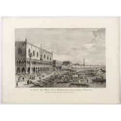
A minore D: Marci Area Dalmatarum ripam.
A minore D: Marci Area Dalmatarum ripam". View of the Riva degli Schiavoni from the east including the Palazzo Ducale in the foreground. Apud Ludovicum Furlanetto su...
Date: Venice, c. 1763
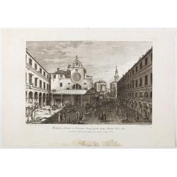
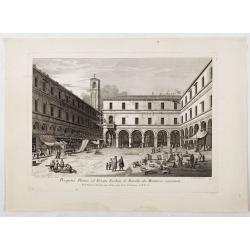
Prospectus Plateae et Ecclesiae Sancti Jacobi prope Pontem Rivi alti.
Prospectus Plateae et Ecclesiae Sancti Jacobi prope Pontem Rivi alti". The Church of San Giacomo di Rialto, at right Palazzo dei Dieci and the bridge of Rialto.From ...
Date: Venice, c. 1763
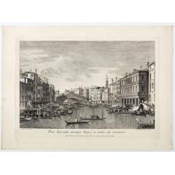
Pons Rivoalti, utriumqque Ripae, et Aedes ad Orientem.
Pons Rivoalti, utriumqque Ripae, et Aedes ad Orientem." From the series "Prospectum Urbis Venetiarum" (Views of Venice). 1st state. Published by Lodovico F...
Date: Venice, 1763
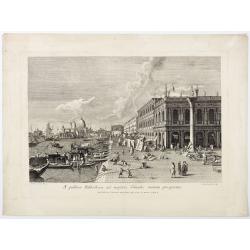
A publica Bibliotheca ad majoris Canalis initium prospectus.
A publica Bibliotheca ad majoris Canalis initium prospectus". View of the Biblioteca Nazionale Marciana, the column of San Teodoro at right, at left the Grand Canal,...
Date: Venice, 1763
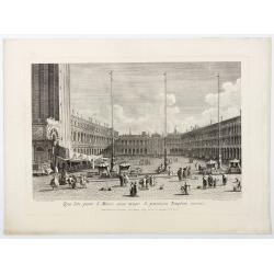
Qua late patet S. Marci area major novum Regim Palatium versus.
Qua late patet S. Marci area major novum Regim Palatium versus". View of piazza San Marco, the church of San Geminiano at the far end, figures and market stalls in t...
Date: Venice, 1763
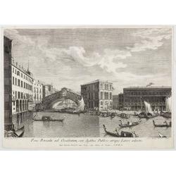
Pons Rivoalti ad Occidentem, cum Aedibus Publicis utrique Lateri adjectis.
Pons Rivoalti ad Occidentem, cum Aedibus Publicis utrique Lateri adjectis."From the series "Prospectum Urbis Venetiarum" (Views of Venice). 1st state. Publ...
Date: Venice, 1763
Prospectus Plateae ad Divum Iacobum de Rivoalto ubi Mercatores conveniunt.
Prospectus Plateae ad Divum Iacobum de Rivoalto ubi Mercatores conveniunt. From the series "Prospectum Urbis Venetiarum" (Views of Venice). Published by Lodovic...
Date: Venice, c. 1763
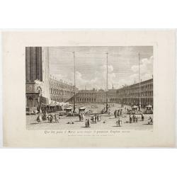
Qua late patet S. Marci area major novum Regim Palatium versus.
Qua late patet S. Marci area major novum Regim Palatium versus". View of piazza San Marco, the church of San Geminiano at the far end, figures and market stalls in t...
Date: Venice, 1763

Het stadhuis, van vooren.
The former Amsterdam Town Hall, now the Royal Palace. Copper engraving by Frans de Bakker after Reinier Vinkeles (1741-1816).From the well-known description of Amsterdam ...
Date: Amsterdam, 1765
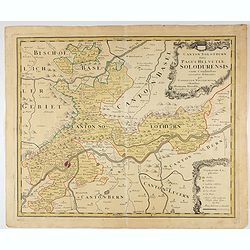
Canton Solothurn sive pagus Helvetiae Solodurensis cum confinibus recenter delineatus per Gabrielem Walserum.
A nice map of Swiss canton centered on Solothurn. Engraved by Tobias C. Lotter.
Date: Augsbourg, 1766
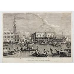
Canalis majoris caput qua Venetias ingreditur.
Bucentaurus et Nundinae Venetae in die Ascensionis". The Doge leaving for the Lido on the Bucintoro on Ascension Day.From the series of 12 views entitled Feste Ducal...
Date: Venice, c. 1766
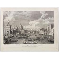
Canalis majoris caput qua Venetias ingreditur.
Canalis majoris caput qua Venetias ingreditur". A view of the Grand Canal with Santa Maria della Salute to the left after Canaletto.From the series of 12 views entit...
Date: Venice, c. 1766

s'Lands en Oost-Indische Lynbanen.
A decorative print of the Lynbanen a place were V.O.C. ship riggings and ropes were produced and kept.
Date: Amsterdam, 1760-1767

t'Oost-Indisch-Huys.
A decorative print of the East Indian House, the headquarters of the V.O.C., a place for meeting, trading and storage of spices and ship equipment. The maps and charts we...
Date: Amsterdam, 1760-1767

s'Lands en Oost-Indische Lynbanen. & t'Oost-Indisch-Huys.
A decorative print of the Lynbanen a place were V.O.C. ship riggings and ropes were produced and kept.
Date: Amsterdam, 1760-1767

Vermakelykheden van Brabant, en deszelfs onderhoorige Landen... (2 volumes)
Topographical and iconographical work on Brabant illustrated with 1 engr. title-vignette and 190 engraved views, plans & armorial plates by J. Harrewijn, G. Bouttats ...
Date: Amsterdam, P.J. Entrop, 1768

Nouveau théâtre de la guerre entre les Russes les turcs et les polonois confédérés.
A very rare separately published map of Crime region. With a large title cartouche lower left "Nouveau theâtre de la guerre entre les russes, les turcs et les polon...
Date: Paris, 1769
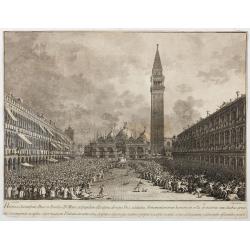
Habita a Serenissimo Duce in Basilica D.Marci ad populum allocutione…
Habita a Serenissimo Duce in Basilica D.Marci ad populum allocutione, ab eoque Dux salutatus, Armamentariorum humeris in sella gestatoria cum duobus proxime consanguineis...
Date: Venice, c. 1766-1770

(upper sheets only) Asia According to the Sieur D'Anville Divided into its Empires, Kingdoms and States Showing the European Settlements in the East Indies and all the New Discoveries . . . 1772
Highly detailed map of Russia, including Turkey, China and Korea. Based on the cartography of the famous French cartographer Jean Baptiste Bourguignon d' Anville. Only th...
Date: London, 1772
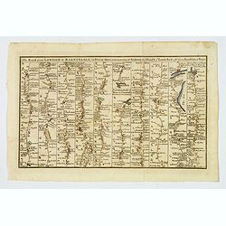
The Road from London to Barnstable, in Devonshire, commencing at Andover, in the road to the Lands End, also from Barnstable to Truro.
A highly detailed late eighteenth century road map, running left to right, commencing at Andover in Hampshire and continuing on to Barnstable in north Devonshire. The map...
Date: London, 1775

Gezicht van het Admiraliteits-Magazyn en Scheeps Timmerwerf.
Formerly the V.O.C. warehouse and arsenal for the Admiralty of Amsterdam, now-a-days the Scheepvaartmuseum (Maritime Museum). Taken from the "Atlas of Amsterdam"...
Date: Amsterdam, 1780

A Perspective View of the Admiralty Office, Dock-Yard, Storehouses &c. at Amsterdam.
Decorative engraving giving good detail of the intense activity in the Amsterdam dockyards.Engraved for BANKES's New System of Geography
Date: Amsterdam, 1780

Vue du Magazin de la Compagnie des Indes Orientales. . .
So-called optical print of the formerly the V.O.C. warehouse and arsenal for the Admiralty of Amsterdam, now-a-days the Scheepvaartmuseum (Maritime Museum).In the eightee...
Date: France, 1780

Madrid.
Extremely rare town-view of Madrid. Engraved by Francesco Ambrosi.With a second title in lower part "Madrid Ciudad Capital Del Reyno D'Espana y real corte de los rey...
Date: Bassano del Grappa, c.1780

La Pologne Dressée sur ce qu'en ot donné Starovolsk, Beauplan, Hartnoch. . .
Large map of Poland, Lithuania, Belarus and part of Ukraine. The map is filled with detail and decorated with a title cartouche flanked by mythological figures.According ...
Date: Paris, 1773 - 1780

Vue perspective de l'interieur de la Salle du spectacle de Veronne en Italie.
Showing the Opera of Verona. Optical print published Mondhare, who was a well-known publisher of optical prints, established in rue St. Jacques in Paris. In the eighteent...
Date: Paris, ca. 1780
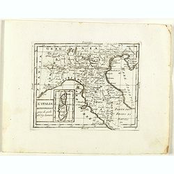
L'Italia Settentrionale presa da quella del Sig. Zannoni.
Rare map of Italy with inset map with Corsica and Sardinia, from "Atlante Novissimo ad uso Dei Giovani Studiosi Contenuto In Carte XXVII.", published by Giovann...
Date: Rome, 1780

Plan de la ville de Maestricht avec ses attaques commandées par M. le maréchal de Saxe, depuis le 15 avril jusqu'au 3 may 1748 . . .
A plan of Maastricht rising after the capture of the city by the French troops led by the Marshal of Saxony. The city was besieged between 15 April and 3 May 1748, during...
Date: Paris, 1781
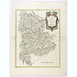
Parte Orientale dell'Elvezia divisa ne'suoi Cantoni di nuova projezione.
Antonio Zatta's detailed map of the eastern part of the Confederation of Switzerland divided into its Cantons. Shows political and administrative boundaries, cities, town...
Date: Venice, 1781
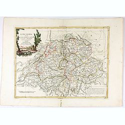
L'Elvezia divisa ne suoi Tredici Cantoni e suoi Alleati di nuova projezione.
Antonio Zatta's detailed map of the Confederation of Switzerland divided into its thirteen Cantons and their allies. Shows political and administrative boundaries, cities...
Date: Venice, 1781
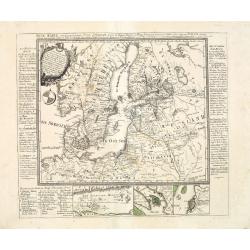
Russian Empire in Europe from the Dr. D'Anville of the Royal Academy. . .
Rare map of Russia, prepared by John Bayly (active 1755-1794) after D'Anville. In the lower-left corner parts of the Caspian and Black Sea. In the upper right corner Nova...
Date: London, ca. 1782
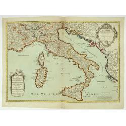
L'Italie distinguée suivant l'estendue de tous les Estats, Royaumes, républiques, Duchés, Principautés, &c.
Decorative map of Italy including Corsica, Sardinia and Sicily engraved by Cordier and published by Desnos. A text at lower right refers to the earthquake of Messine in 1...
Date: Paris, Desnos, 1783
![[2 maps] Partie Septentrionale.. Partie Meridionale du Royaume de Portugal..](/uploads/cache/25084-250x250.jpg)
[2 maps] Partie Septentrionale.. Partie Meridionale du Royaume de Portugal..
A detailed two sheet map of Portugal showing the roads, prepared by N.Bellin. Venetian edition of the map by Bellin, to whom Santini gives credit in the cartouche.From ...
Date: Venice, 1776 - 1784

Campagne du Roi de Prusse de 1778 à 1779.
The book is illustrated with a two-sheet folding map "Carte d'une partie du Royaume de Bohême et de la Moravie ainsi que d'une partie de la Silésie". Prepared...
Date: Geneva, Paris, Mérigot le jeune, 1784
![[Crimea]. Carte de la Cromée.](/uploads/cache/25719-250x250.jpg)
[Crimea]. Carte de la Cromée.
Mapmaker, Captain Jan Hendrik van Kinsbergen (1735-1819). Published by H. Friesman in 1787. This map first appeared in 1776 and was the first Russian map of the newly ann...
Date: Amsterdam, H. Frieseman, 1787

Tableau des guerres de Frédéric le Grand: ou plans figurés de vingt-six batailles rangées, ou combats essentiels donnés dans les trois guerres de Silésie. . .
The book includes a large folded map "Tableaux des Guerres de Frédéric le Grand", showing a map of Prussia, with present-day Poland and Eastern Germany surrou...
Date: Potzdam, Strasbourg, Paris, 1788
![Matelot Hollandais [Dutch sailor]](/uploads/cache/28927-250x250.jpg)
Matelot Hollandais [Dutch sailor]
Etching showing a typical Dutch sailor, after Jacques Grasset de Saint-Sauveur (1757–1810). Taken from "Costumes Civils actuels de tous les peuples connus, dessin�...
Date: Paris, Pavard, 1788

Carte d'Europe divisée en ses Empires et Royaumes.
Uncommon and decorative wall map of Europe, prepared by Clouet. Superb decoration including a wonderful rococo border with vignettes describing historical scenes. Below t...
Date: Paris, Mondhare, 1788
Neue Karte von den gegenwärtigen Kriegs-Schauplatze zwischen den Russisch-Kayserl.
Very rare separately published map showing the Russian War seat including Finland, Lithuania, Denmark and parts of Poland, Norway and Sweden. In lower part inset maps of ...
Date: Leipzig, 1788
S. Georgii Majoris Ecclesiae prospectus.
S. Georgii Majoris Ecclesiae prospectus". S. Giorgio with the church and quay in sharp perspective.From the series "Prospectum Urbis Venetiarum" (Views of ...
Date: Venice, ca. 1791
Veduta della Magnifica REGATA seguita in Venezia li 2. Aprile 1791 alla quale intervennero li Augusti Viaggiator.
Decorative engraving of a Venice regatta on the Grand Canal, by Teodoro Viero (1740-1819) after a paining by Canaletto.The tradition of Venetian origin of the race is lin...
Date: Venice, c. 1791

't dorp Aalst.
Rare print of the old church of Aalst (near Eindhoven), from Vaderlandsche gezichten of afbeeldingen.. by J.Bulthuis, printed by H.Gartman in Amsterdam.
Date: Amsterdam, 1786 / 1792

Imperium Russicum, cum regionibus adiacentibus duabus Tabulis ex optima quae A. 1784 tribus foliis comparavit Mappa geographica, aliisque subsidiis delineatum a C. Mannert, Tabula Ima. . .
A detailed map of the European part of the Russian Empire. Scarce map. Copper etching by C. Mannert and edited by Adam Gottlieb Schneider and Johann Christoph Weigel. Man...
Date: Nuremberg, 1794
L'Europe divisée en des Etats, Empires, Royaumes et Républiques.
Large wall map of Europe with inset map of Iceland and cartouche drawn and etched by Arrivet. Revised edition by Charles François Delamarche (1st ed.: 1767), entitled &q...
Date: Paris, (n.d.) c. 1793/1794

Vue de Malthe du cote du Fort.
A so-called optical print of Valletta seen from the castle. This rare optical print shows people in typical French dresses in the foreground and placed in boats.In the ei...
Date: Paris, 1798
Prise de la ville de Venise le 3 floréal an 5.
Capture of the City of Venice on 3 Floréal, Year V", engraved by Pierre-Adrien Le Beau after Thomas-Charles Naudet. Deposited at the Bibliothèque nationale.During ...
Date: Paris, chez Jean, c. 1798
![[Set of 6 maps] Charta öfver Storfurstendömet Finland på Friherre S. G. Hermelins Anstalt och Omkostnad. Sammandragen och författad af C. P. Hällström. Philos. Magister och Auscultant i Kongl. BergsColl. 1799.](/uploads/cache/34482-250x250.jpg)
[Set of 6 maps] Charta öfver Storfurstendömet Finland på Friherre S. G. Hermelins Anstalt och Omkostnad. Sammandragen och författad af C. P. Hällström. Philos. Magister och Auscultant i Kongl. BergsColl. 1799.
This is a beautiful set of a key map and five separate maps of Samuel Gustav Hermelin's map of Finland. The maps have been engraved by Fredrik Akrel, a very skilled and p...
Date: Källa: J.Strang & E.- S. Harju: Suomen karttakirja 1799

Erfolgte Kapitulation zwischen dem General Bonaparte und den Gross Leister von Malta. Vor der Hauptstadt Walette zu Maltha, am 10 Juni 1798.
Copper engraving with three scenes and one portrait on one sheet. In upper a view of Bonaparte arriving at Valletta. Published in "Allgemeine Welt-Chronik oder neue ...
Date: Zittau, 1798-1800
![[ Manuscript map of the Ligurian coast from Pietra to Genova ].](/uploads/cache/26627-250x250.jpg)
[ Manuscript map of the Ligurian coast from Pietra to Genova ].
Very detailed French manuscript map of the Ligurian coast from Pietra and Finale, Savone to Genoa with the Maritime Alps in the background. The Liguria coast borders to n...
Date: France, ca. 1790-1800

Deutschlands Postkarte begraenzt von Oesterreich, Preussen, Frankreich, Holland, Italien und der Schweiz. . .
A detailed and crucial post-road map prepared by Ignaz Heymann. The map shows the Low Countries, Germany, Poland, Austria, Hungary, etc.Borders in original outline colo...
Date: Triest, 1800

Teatro della guerra nelle Flandre Austriache e Francesi. . .
Rare folio-sized map of Belgium by Antonio Zatta e Figli, from a never-finished atlas by the ‘Società Calcografia’, a partnership of the two main Venetian publishers...
Date: Venise, 1803
L'Isle de CORSE Divisée en ses departemens.
Nice map of Corsica, with a decorative cartouche in the left low corner. Small inset map of Sicily in the upper right corner: "Pointe de Capo Corso".This is the...
Date: Venise,1805
(Post Roads of Europe) Neueste Allgemeine Postkarte von Europa in welcher samtliche Postrouten aller europaischen Staaten nach den zuverlässigsten Postbüchern. . .
The largest postal map of Europe, published in Vienna in the midst of the Napoleonic Wars. This postal map of Europe first appeared in 1798 and is considered one of the e...
Date: Vienna, 1807

Karte vom Koenigreiche Ungarn mit Einschluss der Königreiche Kroazien und Slavonien dann von dem Grossfürstenthume Siebenbürgen.
Wall map of the Kingdom of Hungary in 8 sheets mounted on canvas, preserved in their original case. The map has a graduated margin and is enclosed in a simple yet decorat...
Date: Vienna, 1809
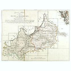
(Index sheet) General Tableau zur Karte von Alt Ost und West Preussen nebst dem aufgenommenen Trigonometrischen Netz. . .
Index sheet of this important multi-sheet map of Prussia, Lithuania, and Poland.Section XXIV of the rare first edition of this important 25-sheet map prepared by Friedric...
Date: Berlin, 1802-1810
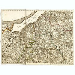
(Sheet X with Puk Bay from) General Tableau zur Karte von Alt Ost und West Preussen nebst dem aufgenommenen Trigonometrischen Netz. . .
Sheet IV with Zalew Wislany and the towns of Elblag, Paslek, Braniewo, etc, of this important multi-sheet map of Prussia, Lithuania, and Poland.The rare first edition of ...
Date: Berlin, 1802-1810

Carte von West=Gallizien welche auf allerhöchsten Befehl Seiner Kaiserlich oesterreichischen und Königlich apostolischen Majestät in den Jahren 1801 bis 1804. . .
Important early map of Western Galicia, as given to Austria by the third Partition of Poland (1795). Due to its lengthy development period, a rare map rich in detail depi...
Date: Vienna, (1808) after 1811
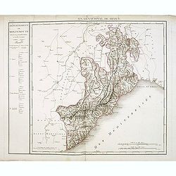
Département de Montenotte Divisé en 4 arrondissemens et en 30 cantons.
Published in the "Atlas National de France" at Chanlaire. Engraved by P.A.F. Tardieu. Represents the department of Apennines which was under French administrati...
Date: Paris, 1790-1811

