Search Listings matching "blaeu" in Europe

Germania.
Second state of this rare "carte à figures"- map of Germany, The Netherlands, Poland and central Europe. Bordered on three sides with portraits and views. In t...
Date: Amsterdam, 1607

Coloniensis Archiepisscopatus.
Extremely rare first edition of this beautiful map of Cologne and Dusseldorff.Jodocus Hondius Jr. planned to produce a new modern atlas less dependent on the Mercator pla...
Date: Amsterdam, 1629
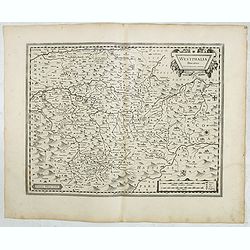
Westphalia Ducatus.
Originally engraved for Jodocus Hondius II, at his death in August 1629 this map was, among 39 other copper plates,purchased by Willem Blaeu who deleted Hondius' name and...
Date: Amsterdam, 1634
Selling price: ????
Please login to see price!
Sold in 2025

Tractus Danubii, Fluminis in Europa Maximi, A Fontibus, Per Germaniam. . .
This is Blaeu’s first map of the Danube and surrounding regions. The Danube River runs through the map from the top left with its headwaters in the German Black Forest ...
Date: Amsterdam, 1634

Nouvelle et exacte Carte du Duche de Brabant. . .
A very rare example of a map of the Duchy of Brabant. Title cartouche in the lower left-hand corner. A very rare issue of this map of Brabant. Cornelis Danckerts II. copi...
Date: Amsterdam, 1635

Ducatus Limburg.
A very rare issue of this map of Limburg. Cornelis Danckerts II copied the folio map of H.Hondius.The publisher's address was placed in the lower right-hand corner. The c...
Date: Amsterdam, 1636

Danubius Fluvius Europae Maximus, a Fontibus ad Ostia..
Depicts the course of the Danube River, from its sources in the Alps to the Black Sea..Because of the dimensions the map was printed from two copper plates.With two very ...
Date: Amsterdam, 1638
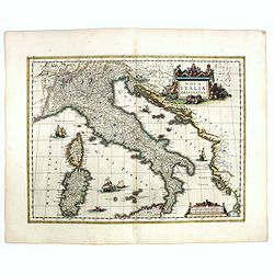
Nova Italiae delineatio.
Originally engraved for Jodocus Hondius II, at his death in August 1629 this map was, among other copper plates,purchased by Willem Blaeu who trimmed the figured borders,...
Date: Amsterdam, 1638

Polonia regnum et Silesia ducatus.
Very decorative map of Poland embellished with two cartouches and two coats of arms surmounted by cherubs and female figures. Showing the region from the Oder east to Pod...
Date: Amsterdam, 1638

Dominio Veneto nell' Italia.
With the Gulf of Venice. Including the towns of Cremona, Brescia, Venice, etc.As Willem Blaeu died in 1638 most of his maps are actually published by his son Joan. This m...
Date: Amsterdam, 1638
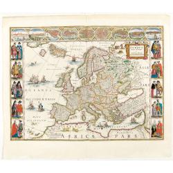
Europa recens descripta à Guilielmo Blaeuw.
On either side columns depicting the manner of dress in the major countries of Europe, surmounted by nine city views and plans.For European mapmakers their own continent ...
Date: Amsterdam, 1644

Europa recens descripta à Guilielmo Blaeuw.
On either side, columns depicting the manner of dress in the major countries of Europe, surmounted by nine city views and plans.For European mapmakers their own continent...
Date: Amsterdam, 1644

Fossa Sanctae Mariae.
Detailed map of part of the country between rivers Rhine and Meuse showing a canal to be dug between 1626 and 1628 between Rheinberg in Germany and Venlo. A deficiency of...
Date: Amsterdam, 1645

Typus Galliae Veteris, Ex conatib' Geograph. Abrah.Ortelii.
A very decorative map with countries of ancient France prepared by Abraham Ortelius and published by one of the most famous map publishers, Willem Blaeu.
Date: Amsterdam, 1645

Quarta pars Brabantiae cujus caput Sylvaducis.
A good and dark impression in strong original colors.The third state. The coat of arms of Brabant and 's-Hertogenbosch appears on the map. The municipal arms in the colum...
Date: Amsterdam, 1645

Quarta pars Brabantiae cujus caput Sylvaducis.
A good and dark impression in strong original colors.The third state. The coat of arms of Brabant and 's-Hertogenbosch appears on the map. The municipal arms in the colum...
Date: Amsterdam, 1645

Russiae vulgo Moscovia dictae, Partes Septentrionalis et orientalis.
In the north the Murmansk Sea. Including the western coast of Nova Zembla. Title cartouche and two cartouches, the bottom right one showing two hunters, bears, stags etc....
Date: Amsterdam, 1647
![[ The repositioning of the Vatican obelisk ]](/uploads/cache/49045-250x250.jpg)
[ The repositioning of the Vatican obelisk ]
Joan Blaeu published The Repositioning of the Vatican Obelisk. This large engraving on multiple sheets and in beautiful original colors is based on Domenico Fontana’s d...
Date: Amsterdam, 1649

Curia Hollandiae Interior. (Binnenhof)
The government center of the Netherlands is situated in and around the Binnenhof-Buitenhof in The Hague. In 1248 the Roman king Willem II built a castle here and named it...
Date: Amsterdam, 1649

Magnus Ducatus Finlandiae Auct. Andrea Bureo Succo.
The first printed survey map of Finland, composed by the Swedish cartographer Anders Bureus (1571-1661). The map was published in 1662 in the second volume of Joan Blaeu'...
Date: Amsterdam, 1660

Norlandiae et quibies Gestricia et Helsingicae regiones Auct: Andrea Buraeo Sueco.
Uncommon map prepared by Anders Bure (1571-1646) with a dedicational cartouche to Gabriel Bengtsson Oxenstierna.The Atlas Maior is the epitome of decades of achievement b...
Date: Amsterdam, 1662
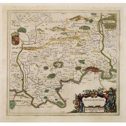
Middle-sexia.
Double-page map of the old Middlesex County, including a marvelous depiction of London on the Thames in the lower right corner. Decorative cartouche and coat of arms. Lat...
Date: Amsterdam, 1662
Selling price: ????
Please login to see price!
Sold in 2024
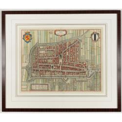
Delfi Batavorum vernacule Delft.
Detailed plan of the city Delft from Frederick de Wit's town book of the Netherlands. The plates are first published by Joan Blaeu one year after the peace of Münster an...
Date: Amsterdam, 1698

Amstelodami celeberrimi hollandiae emporii delineatio nova.
Frederik de Wit’s beautiful bird's-eye view of the city. The Amstel river is still open water flowing through the city's heart. Only near the Dam, has it been covered b...
Date: Amsterdam, c.1700

La Place de Saint Marc a Venise.
A very attractive Town plan of the place St Marc in Venice.Joan Blaeu published during his life three town books of Italy: Citta del Vaticano, Rome, and Napoli. By the ye...
Date: Amsterdam, 1705

Valletta ou Valete ville Forte, de l'Isle de Malta.
A beautifully engraved and richly detailed birds-eye plan of the harbour and city of Valletta seen from the northwest. In lower part extensive key, identifying 57 feautur...
Date: Amsterdam, 1705

Les Provinces confederées du Pais-Bas
The first wall map of the Seven Provinces of 1651, re-issued as 'Stoel des Oorlogs' by Covens & Mortier. The first issue of the present wall-map is known to be includ...
Date: Amsterdam, c. 1740
