Browse Listings in East Meets West > General

Tabula Superioris Indiae & Tartariae maioris. (Modern Map of China, Japan, etc.)
Important map extending from Tartary in the north, to "Prov. Bocat" (Cambodia) in the south. "Tebet" is shown prominently, as is "Zinpangri"...
Date: Vienne, 1541
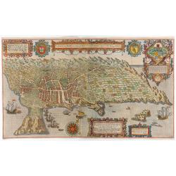
A cidade de Angra na ilha de Iesuxpo da Tercera..
Spectacular perspective view of the harbour and town of Angra on the island of Terceira in the Azores. It was at the time an important port and administrative centre of t...
Date: Amsterdam, 1598
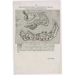
Delineatio Duorum Oppidorum, Ortat.
Early map of the Banda Islands.Theodore de Bry, a German engraver and book dealer, began a compilation of early voyages in 1590 and had published six parts at the time of...
Date: Frankfurt, 1609
Selling price: ????
Please login to see price!
Sold in 2025

Delineatio Civitatis et Castelli Amboinae.
Early view of Ambon, with 6 Dutch vessels offshore.Theodore de Bry, a German engraver and book dealer, began a compilation of early voyages in 1590 and had published six ...
Date: Frankfurt, 1609

A fine bronze cannon.
Cannon built up of two truncated conuses, differing in size, the steps marked by mouldings shaped as flat bands preceded by ogees: base ring similar; breech with ogee-sha...
Date: Amsterdam, ca. 1755
![Sincapour. [Singapore]](/uploads/cache/23696-250x250.jpg)
Sincapour. [Singapore]
Early view of Singapore after Pâris, engraved in aquatint by Sigismond Himely (1801-1872). The view is drawn looking up the Singapore River from South Boat Quay. It sho...
Date: Paris, Finot, 1835

COLLECTION OF HONG KONG MAPS, BOOKS & FLYERS. Including CHINA - HONGKONG surveyed by Captn. Sir Edward Belcher, in H.M.S. Sulphur 1841. Corrected to 1901.
A collection of 30 maps, prints, and publications relating to Hong Kong. Including : - BELCHER, E. Sir, An updated version of this most important nautical chart of Hong K...
Date: London, 1841 - 1901
