Browse Listings in America > South America > Guyana / Suriname
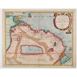
La Guaiane ou Coste Sauvage, autrement El Dorado, et Pais des Amazones…
Extremely rare edition of Du Val's map separately published by Jollain in 1668, referencing the name "El Dorado" in the title of the map. The title translates a...
Date: Paros, Chez Jollain, 1668
F. Louys.
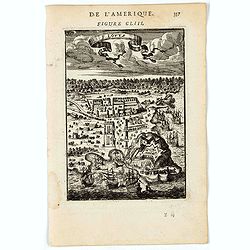
A charming bird's-eye view of Fort St Louis at Cayenne. Title in curtain draped at top. French text on verso.The fort is located on Mont Cépérou, with a panoramic view...
Date: Paris, 1683
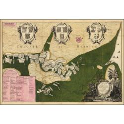
Algemeene kaart van de Colonie of Provintie van Suriname : met de rivieren, districten, ontdekkingen door militaire togten. . .
Uncommon large scale map of Suriname, indicating the different plantations and their owners. Consists of two glued-together sheets. Completed with funding by the Directeu...
Date: Amsterdam, 1740
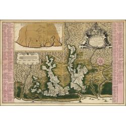
Naaukeurige Platte Grond van den Staat en den Loop van Rio de Berbice Met derzelver Plantagien in de Geoctrojeerde Colonie de Berbice Gelegen. . .
Uncommon large-scale map of Berbice with Rio de Berbice and Rio de Canje with at the bottom left a list of plantation owners. In top 3 x 3 coats of arms in cartouches. Th...
Date: Amsterdam, 1740

Nader prolongatie van het Octroy voor de Westindische Compagnie voor den tyd van nog dertig jaaren. . .
A proclamation by the Dutch States General, dated 1761, extending the charter of the Dutch West India Company for another thirty years. Like the 1730 proclamation, it has...
Date: Amsterdam, 1761

Guyana, Surinam, Amapa.
Very rare Ottoman printed map of Guyana, Suriname and Amapa. With Trinidad, an inset map of the mouth of the Rivers Essequibo, Courantyne, Suriname with Paramaribo.From C...
Date: Uskudar (Istanbul), 1803
Selling price: ????
Please login to see price!
Sold in 2024
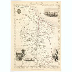
British Guayana.
A decorative steel engraved map of British Guyana. The last Tallis map of the region, published circa 1858 by The London Printing and Publishing Company (the partnership ...
Date: London, 1858

