Subscribe to be notified if similar examples become available.
TERRITORIAL GAINS OF GERMANY UNDER HITLER DURING 1933-1939. |
||||||||||||||||||||
|
||||||||||||||||||||
|
|
||||||||||||||||||||
|
|
Virtual Collection - Save and collect this or any of your favorite items in one place.
If you want to save the items permanently, please sign in or create account first. |
|||||||||||||||||||
Description
(WWII Greek Language Propaganda Map) Hitler, having remedied all losses suffered by Germany under the Treaty of Versailles, started to bring under the authority of the Third Reich all German-speaking peoples, hence the attacks against Austria and Sudeten Czechoslovakia. Upon completion he adopted the watchword of Lebensraum to offer justification for the absorption of Poland and Czechoslovakia.
Hitler had successfully utilised the encirclement tactics in favour of Germany against Czechoslovakia and Poland.
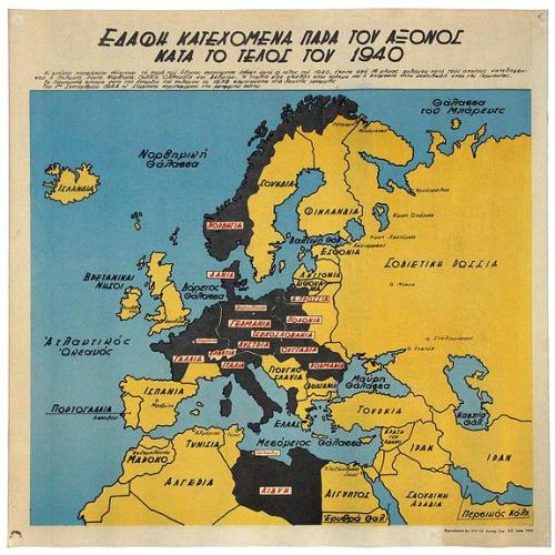
A striking, rare Anti-Axis Propaganda Map in Greek from 1945, targeting the Greeks, made by the 514th Survey Company of the Royal Engineers in May and June of 1945.
The brightly colored map show current and historical configurations of Europe, all of which underline the aggression of Germany. They also highlight the brave actions of the Allies which led to victory across Europe, from Britain to Greece.
At first glance the map appears educational, but their production in May and June 1945 point to their role as propaganda. The Allies, on the verge of victory, wanted to ensure that the Greek people, who had been occupied by the Axis Powers for years and were on the brink of civil war, understood their version of how the war was won. The map marks out the history of German expansion, and their recent contraction.
British Survey Companies in WWII Field Survey Companies, part of the Royal Engineers, served in all theatres of the Second World War. They conducted triangulation and field surveys, drew maps, and printed maps with mobile printing units. They also performed aerial photography and distributed their works to soldiers and approved civilians.
The 514th Survey Company served in the Western Desert theatre, deployed there in the winter of 1940-41. Initially, they mapped for the operations planned against Italy in Eritrea. By mid-1941, they were carrying out large surveys near Matruh, in Egypt. In early 1942, they were working near Benghazi, where they worked on astronomical control points in the desert.
Next, the 514th worked in Syria, where they revised and improved existing maps. While retreating with the Eighth Army back into Egypt in June 1942, they still managed to maintain an active print division. Despite moving five times, the mobile print unit produced over 1,000,000 maps for army use.
The 514th, both its printing unit and surveying details, were then stationed at Alexandria, under the control of A.D. Survey Desert Force. They performed preparatory work at El Alamein which later proved important in the battle of the same name in late 1942. By the end of the year, the 514th was working in Palestine. Later in the war, the 514th helped prepare maps for the invasions of Sicily and mainland Italy.
By the end of the war, when this map was made, the 514th seems to have ramped up its print production to provide not battle maps, but propaganda maps to ensure that the peace went as Britain hoped.
That is, they and their American allies hoped the peace would usher in stable democracies across Europe, as opposed to communist-controlled governments as their ally Russia would have liked. The Cold War was already on the horizon, with Greece as its first battlefield.
This map was likely distributed in Greece at the end of the war. The British Ministry of Information is known to have produced similar propaganda in various languages, but little to no research is available about the role of the Royal Engineers Survey Companies’ role in the creation and distribution. The British Library has no record of similar output by the 514th and they appear to be exceedingly rare survivals.
World War II in Greece.Greece was pulled into WWII by regional tensions. Italy, an ally of Germany as part of the Axis Powers, was tasked with bringing the Balkans and Greece under Axis control. The Italian Army invaded via Albania in late October of 1940. The Greek Army, reinforced by a small contingent of British, Australian, and New Zealand troops, resisted heartily and managed to push the Italians back across the Albanian border.
This resistance was inspiring to the Allies, but it also brought the wrath of Nazi Germany upon the Greek peninsula. The German Army invaded Greece and Yugoslavia in April 1941, overrunning both within a month. The British forces and the Greek royal family fled to Crete and then Egypt. Crete remained as the last free Greek territory until May, when it fell to the Axis Powers thanks to the first large-scale airborne invasion in history.
In Greece, several Field Survey Companies had been sent in with the British troops. Unfortunately, many of their personnel were taken prisoner when Greece was lost to the Axis powers. However, the 514th was not one of the units dispatched in the country.
Although they had enacted heavy casualties on the Axis Powers, especially on the Germans in Crete, Greece was now an occupied state. The Germans, Bulgarians, and Italians split the country in three and set up a puppet government in Athens. The King and his government operated in exile from Egypt. Resistance movements began almost at once, although they were small in scale until mid-1942.
In 1943 and 1944, the resistance factions claimed back large portions of the interior of Greece, particularly in the poorly-policed Italian section of the country. However, the resistance fighters also clashed with each other, as various groups had differing political views. Some wanted a communist country after the war was over, others preferred a return to a monarchical system. Their internal discontent would erupt into the Greek Civil War of 1946-9.
Mainland Greece was released from Axis rule in October 1944, when the German Army pulled back its troops due to the Russian Army’s Baltic Offensive, the Allied advance in Italy, and the loss of Bulgaria as ally. The country the Axis troops left behind was devastated; the economy was shattered and the infrastructure was in ruins. 400,000 Greek people had perished; the Jewish population had been almost completely wiped out as part of the Holocaust. Sadly, a little over a year later, fighting would resume in the Civil War, which pitted American and British-backed conservative fighters against leftists supported by Russia.
The role of the British in promoting their version of history and government are implicated in these maps. They are fascinating historical artefacts that have received little to no scholarly interest despite the larger literature on propaganda maps. They are rare and certainly worth further study; they would make an impressive addition to any collection of wartime and propaganda maps.
Hitler had successfully utilised the encirclement tactics in favour of Germany against Czechoslovakia and Poland.
A striking, rare Anti-Axis Propaganda Map in Greek from 1945, targeting the Greeks, made by the 514th Survey Company of the Royal Engineers in May and June of 1945.
The brightly colored map show current and historical configurations of Europe, all of which underline the aggression of Germany. They also highlight the brave actions of the Allies which led to victory across Europe, from Britain to Greece.
At first glance the map appears educational, but their production in May and June 1945 point to their role as propaganda. The Allies, on the verge of victory, wanted to ensure that the Greek people, who had been occupied by the Axis Powers for years and were on the brink of civil war, understood their version of how the war was won. The map marks out the history of German expansion, and their recent contraction.
British Survey Companies in WWII Field Survey Companies, part of the Royal Engineers, served in all theatres of the Second World War. They conducted triangulation and field surveys, drew maps, and printed maps with mobile printing units. They also performed aerial photography and distributed their works to soldiers and approved civilians.
The 514th Survey Company served in the Western Desert theatre, deployed there in the winter of 1940-41. Initially, they mapped for the operations planned against Italy in Eritrea. By mid-1941, they were carrying out large surveys near Matruh, in Egypt. In early 1942, they were working near Benghazi, where they worked on astronomical control points in the desert.
Next, the 514th worked in Syria, where they revised and improved existing maps. While retreating with the Eighth Army back into Egypt in June 1942, they still managed to maintain an active print division. Despite moving five times, the mobile print unit produced over 1,000,000 maps for army use.
The 514th, both its printing unit and surveying details, were then stationed at Alexandria, under the control of A.D. Survey Desert Force. They performed preparatory work at El Alamein which later proved important in the battle of the same name in late 1942. By the end of the year, the 514th was working in Palestine. Later in the war, the 514th helped prepare maps for the invasions of Sicily and mainland Italy.
By the end of the war, when this map was made, the 514th seems to have ramped up its print production to provide not battle maps, but propaganda maps to ensure that the peace went as Britain hoped.
That is, they and their American allies hoped the peace would usher in stable democracies across Europe, as opposed to communist-controlled governments as their ally Russia would have liked. The Cold War was already on the horizon, with Greece as its first battlefield.
This map was likely distributed in Greece at the end of the war. The British Ministry of Information is known to have produced similar propaganda in various languages, but little to no research is available about the role of the Royal Engineers Survey Companies’ role in the creation and distribution. The British Library has no record of similar output by the 514th and they appear to be exceedingly rare survivals.
World War II in Greece.Greece was pulled into WWII by regional tensions. Italy, an ally of Germany as part of the Axis Powers, was tasked with bringing the Balkans and Greece under Axis control. The Italian Army invaded via Albania in late October of 1940. The Greek Army, reinforced by a small contingent of British, Australian, and New Zealand troops, resisted heartily and managed to push the Italians back across the Albanian border.
This resistance was inspiring to the Allies, but it also brought the wrath of Nazi Germany upon the Greek peninsula. The German Army invaded Greece and Yugoslavia in April 1941, overrunning both within a month. The British forces and the Greek royal family fled to Crete and then Egypt. Crete remained as the last free Greek territory until May, when it fell to the Axis Powers thanks to the first large-scale airborne invasion in history.
In Greece, several Field Survey Companies had been sent in with the British troops. Unfortunately, many of their personnel were taken prisoner when Greece was lost to the Axis powers. However, the 514th was not one of the units dispatched in the country.
Although they had enacted heavy casualties on the Axis Powers, especially on the Germans in Crete, Greece was now an occupied state. The Germans, Bulgarians, and Italians split the country in three and set up a puppet government in Athens. The King and his government operated in exile from Egypt. Resistance movements began almost at once, although they were small in scale until mid-1942.
In 1943 and 1944, the resistance factions claimed back large portions of the interior of Greece, particularly in the poorly-policed Italian section of the country. However, the resistance fighters also clashed with each other, as various groups had differing political views. Some wanted a communist country after the war was over, others preferred a return to a monarchical system. Their internal discontent would erupt into the Greek Civil War of 1946-9.
Mainland Greece was released from Axis rule in October 1944, when the German Army pulled back its troops due to the Russian Army’s Baltic Offensive, the Allied advance in Italy, and the loss of Bulgaria as ally. The country the Axis troops left behind was devastated; the economy was shattered and the infrastructure was in ruins. 400,000 Greek people had perished; the Jewish population had been almost completely wiped out as part of the Holocaust. Sadly, a little over a year later, fighting would resume in the Civil War, which pitted American and British-backed conservative fighters against leftists supported by Russia.
The role of the British in promoting their version of history and government are implicated in these maps. They are fascinating historical artefacts that have received little to no scholarly interest despite the larger literature on propaganda maps. They are rare and certainly worth further study; they would make an impressive addition to any collection of wartime and propaganda maps.
FAQ - Guarantee - Shipping
Buying in the BuyNow Gallery
This item is available for immediate purchase when a "Add to Cart" or "Inquire Now" button is shown.
Items are sold in the EU margin scheme
Payments are accepted in Euros or US Dollars.
Authenticity Guarantee
 We provide professional descriptions, condition report (based on 45 years experience in the map business)
Paulus Swaen warrants the authenticity of our items and a certificate of authenticity is provided for each acquired lot.
Condition and Coloring
We indicate the condition of each item and use our unnique HiBCoR grading system in which four key items determine a map's value: Historical Importance, Beauty, Condition/Coloring and Rarity.
Color Key
We offer many maps in their original black and white condition. We do not systematically color-up maps to make them more sellable to the general public or buyer.
Copper engraved or wood block maps are always hand colored. Maps were initially colored for aesthetic reasons and to improve readability. Nowadays, it is becoming a challenge to find maps in their original colors and are therefor more valuable.
We use the following color keys in our catalog:
Original colors; mean that the colors have been applied around the time the map was issued.
Original o/l colors; means the map has only the borders colored at the time of publication.
Colored; If the colors are applied recently or at the end of the 20th century.
Read more about coloring of maps [+]
Shipping fee
A flat shipping fee of $ 30 is added to each shipment by DHL within Europe and North America. This covers : International Priority shipping, Packing and Insurance (up to the invoice amount).
Shipments to Asia are $ 40 and rest of the world $50
We charge only one shipping fee when you have been successful on multiple items or when you want to combine gallery and auction purchases.
Read more about invoicing and shipping
FAQ
Please have a look for more information about buying in the BuyNow gallery
Many answers are likely to find in the general help section.
Virtual Collection
![]()
With Virtual Collection you can collect all your favorite items in one place. It is free, and anyone can create his or her Virtual map collection.
Unless you are logged in, the item is only saved for this session. You have to be registed and logged-in if you want to save this item permanently to your Virtual Collection.
Read More[+]
Register here, it is free and you do not need a credit card.
Add this item to
Virtual Collection
or click the following link to see my Virtual Collection.
| Digital Image Download | |
|
Paulus Swaen maintains an archive of most of our high-resolution rare maps, prints, posters and medieval manuscript scans. We make them freely available for download and study. Read more about free image download |
Click the image for a free small image download. |
In accordance with the EU Consumer Rights Directive and habitually reside in the European Union you have the right to cancel the contract for the purchase of a lot, without giving any reason.
The cancellation period will expire 14 calendar days from the day after the date on which you or a third party (other than the carrier and indicated by you) acquires, physical possession of the lot. To exercise the right to cancel you must inform Paulus Swaen Inc, of your decision to cancel this contract by a clear statement (e.g. a letter sent by post, or e-mail (amsterdam@swaen.com).
To meet the cancellation deadline, it is sufficient for you to send your communication concerning your exercise of the right to cancel before the cancellation period has expired.
