Subscribe to be notified if similar examples become available.
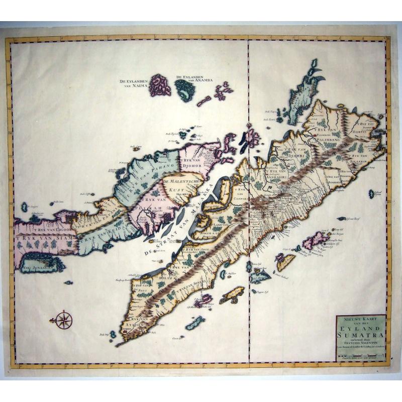
(Singapore),- Nieuwe Kaart van het EYLAND SUMATRA. . . |
||||||||||||||||||||
|
||||||||||||||||||||
|
|
||||||||||||||||||||
Estimated value: $900 - $1320 |
My Collection +
Add this or any of your favorite items in one place. If you want to save the items permanently, you have to sign in or create an account first. |
|||||||||||||||||||
Description
A superb example of Francois Valentijn's 1724 map of Malaya (Malaysia and Singapore) and Sumatra. Oriented to the east, Valentijn's spectacular map covers from the Island of Junsalan (Penang / Prince of Wales Island / Pulu Pinang) south as far as the Straits of Sunda and west to Atsjien (Banda Aceh) at the western tip of Sumatra.
It extends eastwards to the Anambas Islands and the Bangka-Belitung Islands. The cartographer identifies various polities as well as numerous coastal settlements and cities. Topography is rendered in profile and limited submarine detail is presented in the Strait of Malacca.
Little interior detail is given but the coastlines, settlements, and principal coastal features are identified. An attractive early map, and one of the few early Dutch maps to focus on the region.
Senasur appears to be on the wrong side of the Johor River, while there is a city named Sincapoera, what can definitely be identified as Singapore. It's just west on the map of a city named Passir, as indeed Singapore is west of Pasir Gudang.
Valentijn's map is one of the first published to present a sophisticated treatment of Malays and Sumatra, and the model upon which most subsequent maps through the late 18th century were based. This is one of the earliest maps to expound upon the indigenous polities of Malaya.
Valentijn identifies seven separate kingdoms within the peninsula. The presentation thus represents a major change in Malayan politics following the Dutch capture of Portuguese Malacca in 1606.
The Dutch forged a peaceful arrangement with the Sultan of Johor, leading to a time of general peace and prosperity in the region. This prosperity, combined with the decline of the Sunnite of Aceh in northern Sumatra, allowed for the rapid development and expansion of smaller polities throughout the peninsula, these include Johor, Perak, Pahang, Patani, Kedah, and Ligor - the latter two of which, as noted here, fell under the sway of Siam. Valentijn moreover, has recorded some 80 place names in Malaya alone, and far more in Sumatra, far more than any predecessor had attempted.
Possibly the most beautiful printed map of Malay ever made.
Francois Valentijn (1666–1727) was a minister, naturalist and writer. He is best known for his Oud en Nieuw Oost-Indien(“Old and New East-India”), a book about the history of the Dutch East India Company and the countries of the Far East.
Valentijn was born in 1666 in Dordrecht, Holland, but spent significant time in the tropics, notably in Ambon, in the Maluku Archipelago. In total, Valentijn lived in the East Indies for 16 years. Valentijn was first employed by the Dutch V.O.C. or East India Company (Vereenigde Oost-Indische Compagnie) at the age of 19, where he served as Minister to the East Indies. He returned to Holland for about ten years, before returning to the Indies in 1705 where he was to serve as Army Chaplain on an expedition in eastern Java.
He again returned to Dordrecht where he wrote his Oud en Nieuw Oost-Indien (1724–26), a massive work of five parts published in eight volumes and containing over one thousand illustrations and including some of the most accurate maps of the Indies of the time. He died in The Hague, Netherlands, in 1727.
Valentijn probably had access to the V.O.C.’s archive of maps and geographic secrets which they had always guarded jealously. Johannes Van Keulen II became Hydrographer to the V.O.C. in the same year Valentijn’s book was published. It was in Van Keulens time that many of the VOC charts were published, one signal of the decline of Dutch dominance in the Spice Trade.
Valentijn was fortunate to have seen his work published, as the VOC (Dutch East India Company) strictly enforced a policy prohibiting former employees from publishing anything about the region or their colonial administration. And while, as Suárez notes, by the mid-18th Century the Dutch no longer feared sharing geographic secrets, the execution of this policy was still erratic and based on personal motives.
Reference: Landwehr (VOC), 467.5a(10); Durant-Curtis, #38.
FAQ - Guarantee - Shipping
994 BuyBidBuying in the BuyNow Gallery
This item is available for immediate purchase when a "Add to Cart" or "Inquire Now" button is shown.
Payments are accepted in Euros or US Dollars. We accept most major credit cards, PayPal and bank transfer.
Authenticity Guarantee
 We provide professional descriptions, condition report and HiBCoR rating (based on 45 years experience in the map business)
We fully guarantee the authenticity of items we sell. We provide a certificate of authenticity for each purchased item.
Condition / Coloring
We indicate the condition of each item and use our unnique HiBCoR grading system in which four key items determine a map's value: Historical Importance, Beauty, Condition/Coloring and Rarity.
We offer many maps in their original black and white condition. We do not systematically color-up maps to make them more sellable to the general public or buyer.
Copper engraved or wood block maps are always hand colored. Maps were initially colored for aesthetic reasons and to improve readability. Nowadays, it is becoming a challenge to find maps in their original colors and are therefor more valuable.
We use the following color keys in our catalog:
Original colors; mean that the colors have been applied around the time the map was issued.
Colored; If the colors are applied recently or at the end of the 20th century, then "colored", or "attractive colors" will be used.
Original o/l colors; means the map has only the borders colored at the time of publication.
Read more about coloring of maps [+]
FAQ
Please have a look for more information about buying in the BuyNow gallery.
Many answers are likely to find in the general help section.
My Collection+
![]()
With My Collection+ you can collect all your favorite items in one place. It is free, and anyone can create his or her virtual map collection.
Unless you are logged in, the item is only saved for this session. You have to be registed and logged-in if you want to save this item permanently to My Collection+.
Read More [+]
If you want to save the items permanently, please sign in
or create account first. ![]()
Registering Here, it is and you do not need a credit card.
Add this item to
My Collection+
or click the following link to see My Collection+.
Invoice
The invoice and certificates of authenticity are available in the client center >Invoices
| Digital Image Download | |
|
Paulus Swaen maintains an archive of most of our high-resolution rare maps, prints, posters and medieval manuscript scans. We make them freely available for download and study. Read more about free image download |
Click the image for a free small image download. |
In accordance with the EU Consumer Rights Directive and habitually reside in the European Union you have the right to cancel the contract for the purchase of a lot, without giving any reason.
The cancellation period will expire 14 calendar days from the day after the date on which you or a third party (other than the carrier and indicated by you) acquires, physical possession of the lot. To exercise the right to cancel you must inform Paulus Swaen Inc, of your decision to cancel this contract by a clear statement (e.g. a letter sent by post, or e-mail.
To meet the cancellation deadline, it is sufficient for you to send your communication concerning your exercise of the right to cancel before the cancellation period has expired.
