Subscribe to be notified if similar examples become available.

Serbia/Bosnia Wallmap,- Theatrum belli inter imperat. Carol VI et sult. Achmet IV in partibus regnorum Serviae et Bosniae ex authenticis subsidys delineatum a Ioh. Fr. Ottingero. |
||||||||||||||||||||
|
||||||||||||||||||||
|
|
||||||||||||||||||||
Estimated value: $1000 - $1500 |
My Collection +
Add this or any of your favorite items in one place. If you want to save the items permanently, you have to sign in or create an account first. |
|||||||||||||||||||
Description
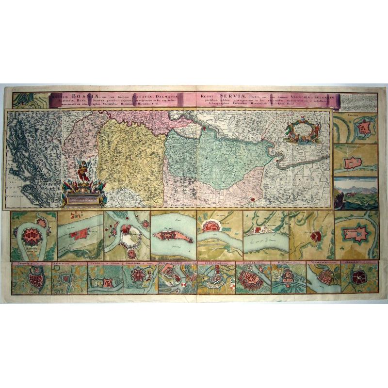
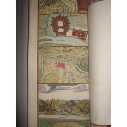
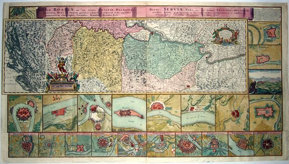
A rare, extra large, ca 1739, Homann Heirs map of the Balkans printed from 5 plates - with a moving part [please view suppl. picture], and the lower 10 plans which are often missing.
The map was drawn by the royal military engineer Johann Friedrich (Franz) Ottinger (fl. ca 1734-1765) to illustrate the events of the Austro-Turkish War of 1737-1739.
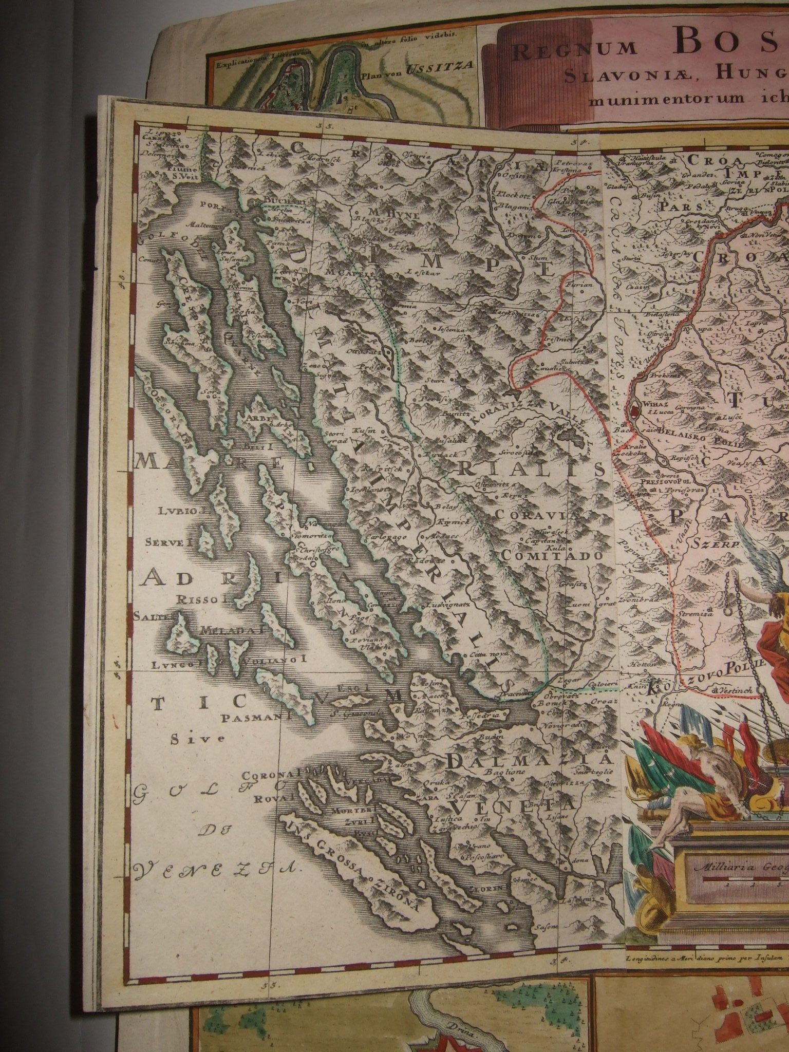
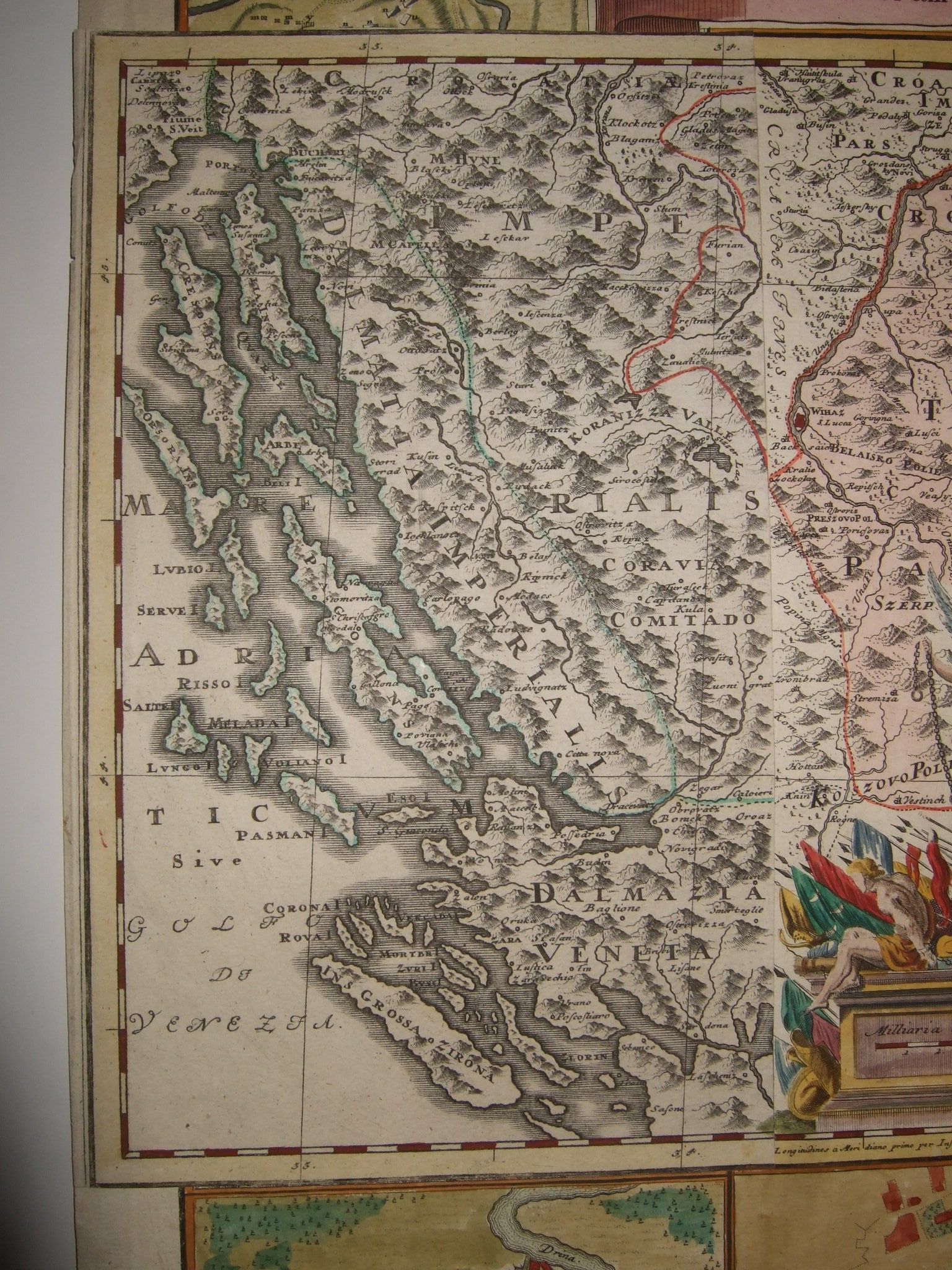
The coverage extends from the Dalmatian coast to Walachia to the city of Nissa, including Bosnia, Serbia, Croatia, and parts of Slovenia and Bulgaria.
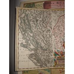
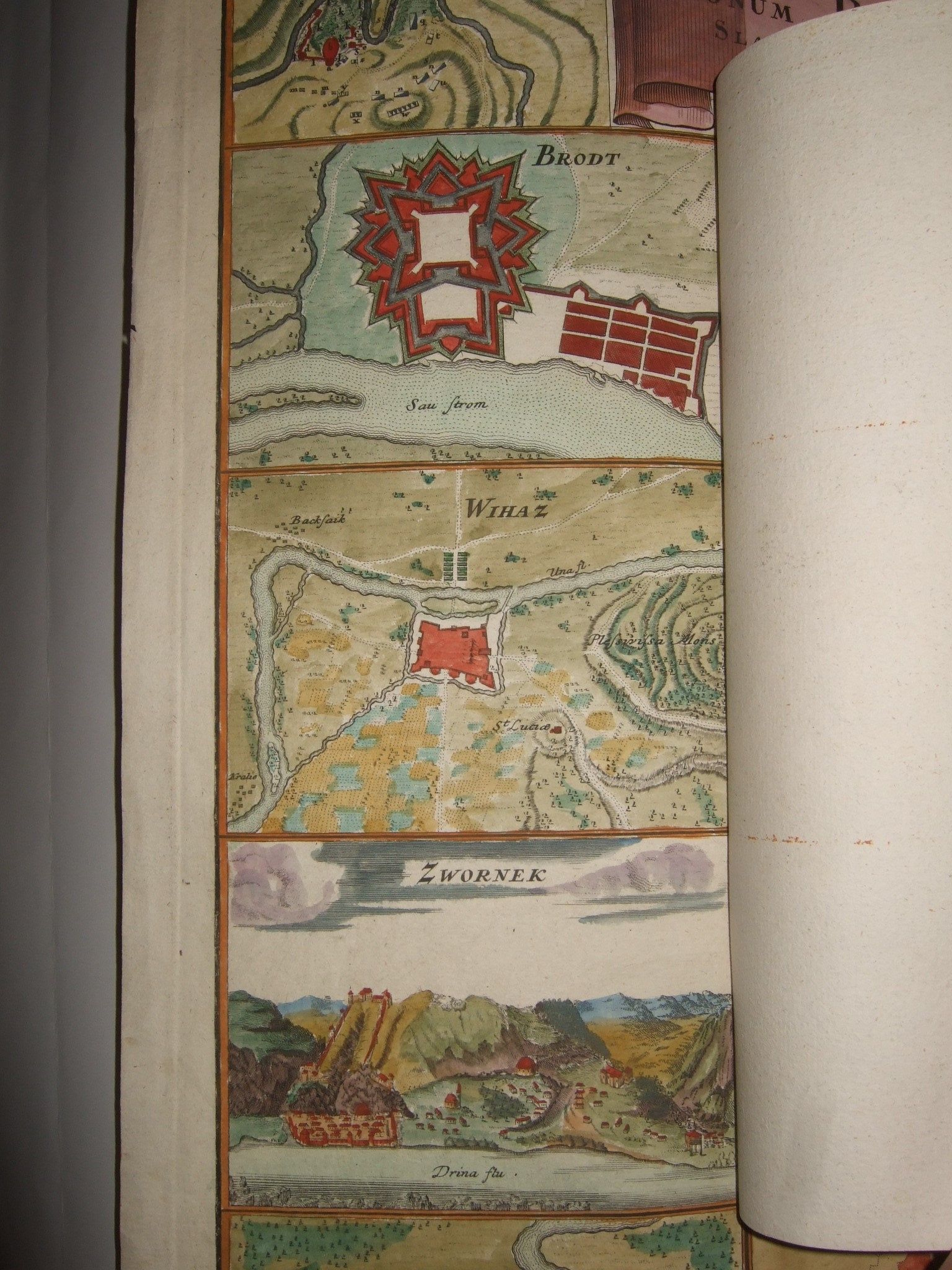
The map is surrounded by 25 views and plans, illustrating Banialucka (Banja Luka), Belgrad (Beograd), Brodt (Slavonski Brod), Carlstadt (Karlovac), Chatchek (Cacak), Esseck (Osijek), Krakoievaz (Kragujevac), Nicopolis (Nikopol), Nissa (Nis), Orsava (Orsova), Peterwardin (Petrovaradin), Ratscha (Raca), Sabatz (Sabac), Seraglio (Sarajevo), Temeswar (Timisoara), Ussitza (Uzice), Valiova (Valjevo), Vipalancka (Palanka), Widdin (Vidin), Wihaz (Bihac), and Zwornek (Zvornik).
There is an unusual foldout on the left side that expands coverage to include the Dalmatia. Few examples of the map retain the foldout !
Austro-Turkish War (1737 - 1739): In the long list of conflicts between the Austro-Hungarian Empire and the Ottoman Empire, this war is often barely a footnote. The war was an extension of the Russo-Turkish War (1735-1739). Under Hapsburg Charles VI (1685 - 1740) Austria entered the war as an ally of Russia, leading to Austro-Turkish conflicts in the Balkans. Austrian forces proved ineffective against the Turks, despite the fact that the Ottomans were fighting a 2-front war.
In the Balkans, Austria lost the Battle of Banja Luka in August of 1737, the Battle of Grocka in July of 1739, and were driven out of Belgrade after an Ottoman siege from July to September 1739. Austria finally signed the Belgrade Peace on September 18, 1739.
Census and Publication History: Most scholarship dates this map to 1736, however research of the events depicted suggest a later date of 1739. Many surviving examples do not have the fold out. This map appears to have been issued separately but is sometimes found bound into various Homann atlases.
FAQ - Guarantee - Shipping
994 BuyBidBuying in the BuyNow Gallery
This item is available for immediate purchase when a "Add to Cart" or "Inquire Now" button is shown.
Payments are accepted in Euros or US Dollars. We accept most major credit cards, PayPal and bank transfer.
Authenticity Guarantee
 We provide professional descriptions, condition report and HiBCoR rating (based on 45 years experience in the map business)
We fully guarantee the authenticity of items we sell. We provide a certificate of authenticity for each purchased item.
Condition / Coloring
We indicate the condition of each item and use our unnique HiBCoR grading system in which four key items determine a map's value: Historical Importance, Beauty, Condition/Coloring and Rarity.
We offer many maps in their original black and white condition. We do not systematically color-up maps to make them more sellable to the general public or buyer.
Copper engraved or wood block maps are always hand colored. Maps were initially colored for aesthetic reasons and to improve readability. Nowadays, it is becoming a challenge to find maps in their original colors and are therefor more valuable.
We use the following color keys in our catalog:
Original colors; mean that the colors have been applied around the time the map was issued.
Colored; If the colors are applied recently or at the end of the 20th century, then "colored", or "attractive colors" will be used.
Original o/l colors; means the map has only the borders colored at the time of publication.
Read more about coloring of maps [+]
FAQ
Please have a look for more information about buying in the BuyNow gallery.
Many answers are likely to find in the general help section.
My Collection+
![]()
With My Collection+ you can collect all your favorite items in one place. It is free, and anyone can create his or her virtual map collection.
Unless you are logged in, the item is only saved for this session. You have to be registed and logged-in if you want to save this item permanently to My Collection+.
Read More [+]
If you want to save the items permanently, please sign in
or create account first. ![]()
Registering Here, it is and you do not need a credit card.
Add this item to
My Collection+
or click the following link to see My Collection+.
Invoice
The invoice and certificates of authenticity are available in the client center >Invoices
| Digital Image Download | |
|
Paulus Swaen maintains an archive of most of our high-resolution rare maps, prints, posters and medieval manuscript scans. We make them freely available for download and study. Read more about free image download |
Click the image for a free small image download. |
In accordance with the EU Consumer Rights Directive and habitually reside in the European Union you have the right to cancel the contract for the purchase of a lot, without giving any reason.
The cancellation period will expire 14 calendar days from the day after the date on which you or a third party (other than the carrier and indicated by you) acquires, physical possession of the lot. To exercise the right to cancel you must inform Paulus Swaen Inc, of your decision to cancel this contract by a clear statement (e.g. a letter sent by post, or e-mail.
To meet the cancellation deadline, it is sufficient for you to send your communication concerning your exercise of the right to cancel before the cancellation period has expired.
