![Schat-Kamer ofte konst der stuurlieden, behelzende een duidelyke onderwyzinge in de navigatie. . . [bound with] Tafelen bevattende De Sinussum, tangenten en Secanten. . . [bound with] Geographische Tadfel...](/uploads/cache/33112-800x800.jpg)
![Schat-Kamer ofte konst der stuurlieden, behelzende een duidelyke onderwyzinge in de navigatie. . . [bound with] Tafelen bevattende De Sinussum, tangenten en Secanten. . . [bound with] Geographische Tadfel...](/uploads/cache/33112A-800x800.jpg)
![Schat-Kamer ofte konst der stuurlieden, behelzende een duidelyke onderwyzinge in de navigatie. . . [bound with] Tafelen bevattende De Sinussum, tangenten en Secanten. . . [bound with] Geographische Tadfel...](/uploads/cache/33112B-800x800.jpg)
![Schat-Kamer ofte konst der stuurlieden, behelzende een duidelyke onderwyzinge in de navigatie. . . [bound with] Tafelen bevattende De Sinussum, tangenten en Secanten. . . [bound with] Geographische Tadfel...](/uploads/cache/33112BB-800x800.jpg)
![Schat-Kamer ofte konst der stuurlieden, behelzende een duidelyke onderwyzinge in de navigatie. . . [bound with] Tafelen bevattende De Sinussum, tangenten en Secanten. . . [bound with] Geographische Tadfel...](/uploads/cache/33112-250x250.jpg)
![Schat-Kamer ofte konst der stuurlieden, behelzende een duidelyke onderwyzinge in de navigatie. . . [bound with] Tafelen bevattende De Sinussum, tangenten en Secanten. . . [bound with] Geographische Tadfel...](/uploads/cache/33112A-250x250.jpg)
![Schat-Kamer ofte konst der stuurlieden, behelzende een duidelyke onderwyzinge in de navigatie. . . [bound with] Tafelen bevattende De Sinussum, tangenten en Secanten. . . [bound with] Geographische Tadfel...](/uploads/cache/33112B-250x250.jpg)
![Schat-Kamer ofte konst der stuurlieden, behelzende een duidelyke onderwyzinge in de navigatie. . . [bound with] Tafelen bevattende De Sinussum, tangenten en Secanten. . . [bound with] Geographische Tadfel...](/uploads/cache/33112BB-250x250.jpg)
Schat-Kamer ofte konst der stuurlieden, behelzende een duidelyke onderwyzinge in de navigatie. . . [bound with] Tafelen bevattende De Sinussum, tangenten en Secanten. . . [bound with] Geographische Tadfel... |
||||||||||||||||||||
|
||||||||||||||||||||
|
|
||||||||||||||||||||
$2000 / ≈ €1722This item is available for immediate sale! Questions before Buying ?
We are happy to answer your questions.
2000.00
|
Virtual Collection - Save and collect this or any of your favorite items in one place.
If you want to save the items permanently, please sign in or create account first. |
|||||||||||||||||||
Description
Schat-Kamer ofte konst der stuurlieden, behelzende een duidelyke onderwyzinge in de navigatie. . . [bound with] Tafelen bevattende De Sinussum, tangenten en Secanten. . . [bound with] Geographische Tadfel vande Graaden.. Voornaamste Zee-haavens. .
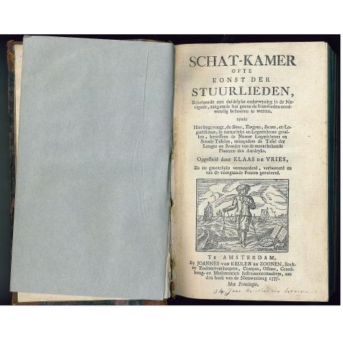
Rare and important manual originally prepared by Klaas de Vries including "Schat-Kamer ofte konst der stuurlieden" (Treasure-room of the art of Navigation) and published by Johannes van Keulen [bound with] Tafelen bevattende De Sinussum, tangenten en Secanten. . . [bound with] Geographische Tafel vande Graaden. . . Voornaamste Zee-haavens. ..In 1702 appeared with the Amsterdam publisher Johannes Loots a handbook about the art of navigation which proved to be very popular and during the century more than once was issued.
It was the "Schat-Kamer ofte konst der stuurlieden" (Treasure-room of the Art of Navigation) by the Amsterdam teacher in mathematics Klaas de Vries. The book gives a clear picture of several aspects of maritime navigation.
An important issue in the "Treasure-room" is the height measurement of the sun or a star above the horizon, in order to calculate the latitude, as well as how to calculate the meridian.
De Vries mentioned that on board celestial globes were used and he described the three by Dutch sailors most common used instruments for height measurement. He considered the "graadstok" or "Jacobsstaf" (Cross-staff) as the most important, the other were the "Davis quadrant" and the "spiegelboog" (Mirror-staff). The latter was in 1660 invented by Joost van Breen, a ship provisions-master of the VOC chamber Zeeland.
De Vries described the Cross-staff the most comprehensive and explained how the sailor could make one him selves (pp.286-293).
He discussed the "apparent" altitude of a celestial body above the horizon and the necessary corrections to be implemented to calculate the "true" height and he therefore provided the necessary tables.
The "Treasure-room" explained how to calculate the times of high and low water. Knowledge important for departure and arrival at ports.
Navigational guidance, such as meridians, "breedteparallellen", the equator and the tropics, were explained by De Vries. He discussed the compass, compass needles and the variation, application of which was important for safe navigation.
The Treasure-room described how the length of a day and night and the times of rise and fall of the sun were calculated.
For this 1777 edition the wind directions for the route between the Netherlands and Java has been replaced by "triangle measurement ".<
A topic that got special attention was the actual position finding on a "platte en de wassende kaart" (Mercator projection chart) done by measuring the distance traveled in nautical miles. The distance was noted in a "handlog" and the speed of the vessel was measured regularly. The log consisted of a buttons labeled long line, rolled on a reel, and at the end a triangular shelf with some lead. One threw the plank at the stern into the sea where it floated and the mate counted with the aid of a hourglass for fifteen seconds, the number of passing nodes. That number corresponded to the speed in miles per hour.
The Treasure-room contained a large number of examples of the various types of calculations and included many sinus, tangent and secant tables by Bernardus Joannes Douwes.
The Treasure-Room contained a large number of examples of various types of calculations. These were training issues were the prospective mate could improve skills and test his knowledge.
On ocean routes however the knowledge of sea currents, and prevailing and seasonal winds remained knowledge based on experience of generation to generation which was passed by the sailor. The "Schat-Kamer" however offered the Dutch sailor the basis of maritime navigation for more than a century.
At the end we find a 40 page listing "Geographische Tafel van de graaden dere breedte en poolshoogte en lengte of middagscirkel, van de Meest Bekende Steeden, rivieren, caapen, Baayen. En inzonderheid der voornaamste Zee-Havens des Aardryks.
Of Korean interest is page 12, with "Corea, op de Zuid-Kust van China. Latitude 34-50 N. Longitude 142-22".
Interesting reading : http://www.knaw.nl/Content/Internet_KNAW/publicaties/pdf/20031017.pdf
FAQ - Guarantee - Shipping
Buying in the BuyNow Gallery
This item is available for immediate purchase when a "Add to Cart" or "Inquire Now" button is shown.
Items are sold in the EU margin scheme
Payments are accepted in Euros or US Dollars.
Authenticity Guarantee
 We provide professional descriptions, condition report (based on 45 years experience in the map business)
Paulus Swaen warrants the authenticity of our items and a certificate of authenticity is provided for each acquired lot.
Condition and Coloring
We indicate the condition of each item and use our unnique HiBCoR grading system in which four key items determine a map's value: Historical Importance, Beauty, Condition/Coloring and Rarity.
Color Key
We offer many maps in their original black and white condition. We do not systematically color-up maps to make them more sellable to the general public or buyer.
Copper engraved or wood block maps are always hand colored. Maps were initially colored for aesthetic reasons and to improve readability. Nowadays, it is becoming a challenge to find maps in their original colors and are therefor more valuable.
We use the following color keys in our catalog:
Original colors; mean that the colors have been applied around the time the map was issued.
Original o/l colors; means the map has only the borders colored at the time of publication.
Colored; If the colors are applied recently or at the end of the 20th century.
Read more about coloring of maps [+]
Shipping fee
A flat shipping fee of $ 30 is added to each shipment by DHL within Europe and North America. This covers : International Priority shipping, Packing and Insurance (up to the invoice amount).
Shipments to Asia are $ 40 and rest of the world $50
We charge only one shipping fee when you have been successful on multiple items or when you want to combine gallery and auction purchases.
Read more about invoicing and shipping
FAQ
Please have a look for more information about buying in the BuyNow gallery
Many answers are likely to find in the general help section.
Virtual Collection
![]()
With Virtual Collection you can collect all your favorite items in one place. It is free, and anyone can create his or her Virtual map collection.
Unless you are logged in, the item is only saved for this session. You have to be registed and logged-in if you want to save this item permanently to your Virtual Collection.
Read More[+]
Register here, it is free and you do not need a credit card.
Add this item to
Virtual Collection
or click the following link to see my Virtual Collection.
| Digital Image Download | |
|
Paulus Swaen maintains an archive of most of our high-resolution rare maps, prints, posters and medieval manuscript scans. We make them freely available for download and study. Read more about free image download |
Click the image for a free small image download. |
![Rare, antique map of Schat-Kamer ofte konst der stuurlieden, behelzende een duidelyke onderwyzinge in de navigatie. . . [bound with] Tafelen bevattende De Sinussum, tangenten en Secanten. . . [bound with] Geographische Tadfel...](/uploads/33112.jpg)
![Rare, antique map of Schat-Kamer ofte konst der stuurlieden, behelzende een duidelyke onderwyzinge in de navigatie. . . [bound with] Tafelen bevattende De Sinussum, tangenten en Secanten. . . [bound with] Geographische Tadfel...](/uploads/33112A.jpg)
![Rare, antique map of Schat-Kamer ofte konst der stuurlieden, behelzende een duidelyke onderwyzinge in de navigatie. . . [bound with] Tafelen bevattende De Sinussum, tangenten en Secanten. . . [bound with] Geographische Tadfel...](/uploads/33112B.jpg)
![Rare, antique map of Schat-Kamer ofte konst der stuurlieden, behelzende een duidelyke onderwyzinge in de navigatie. . . [bound with] Tafelen bevattende De Sinussum, tangenten en Secanten. . . [bound with] Geographische Tadfel...](/uploads/33112BB.jpg)
In accordance with the EU Consumer Rights Directive and habitually reside in the European Union you have the right to cancel the contract for the purchase of a lot, without giving any reason.
The cancellation period will expire 14 calendar days from the day after the date on which you or a third party (other than the carrier and indicated by you) acquires, physical possession of the lot. To exercise the right to cancel you must inform Paulus Swaen Inc, of your decision to cancel this contract by a clear statement (e.g. a letter sent by post, or e-mail (amsterdam@swaen.com).
To meet the cancellation deadline, it is sufficient for you to send your communication concerning your exercise of the right to cancel before the cancellation period has expired.
