Subscribe to be notified if similar examples become available.
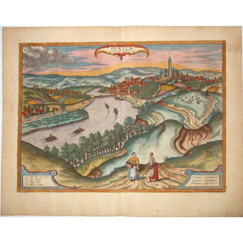
PENIG, SAXONIA,- PENIGK, MISNIAE OPPIDUM |
||||||||||||||||||||
|
||||||||||||||||||||
|
|
||||||||||||||||||||
Estimated value: $300 - $430 |
My Collection +
Add this or any of your favorite items in one place. If you want to save the items permanently, you have to sign in or create an account first. |
|||||||||||||||||||
Description
An original antique copper-engraving after J. Hoefnagel's drawing of 1617. From the 6th part of Latin ed. of Braun and Hogenberg's "Civitates Orbis Terrarum", published by A. Hierat in Cologne, 1617. With ornamental title cartouche, a cartouche with explanatory notes (A-D), another cartouche with Hoefnagel's address, and two figures in the foreground.
This view comes from the sixth and last volume of 'Civitates Orbis Terrarum' ("Theatri Praecipuarum Totius Mundi Urbivm Liber Sextus"), published in a much smaller edition than previous volumes, and it is, therefore, rarer than most of Braun & Hogenberg city views.
COMMENTARY BY BRAUN (on verso): "Scarcely 300 years ago this whole area was a nest of robbers and murderers, until finally Margrave Frederick of Meissen cleared and liberated all the highways and byways in his land. This town lies on the Mulde at a place where a chapel dedicated to Our Lady once stood, to which came many visitors and pilgrims from distant countries.
When some people noticed that there were benefits to be obtained from the great number of pilgrims, they settled here in order to provide hospitality for them. In this way, the pilgrimage and the town grew steadily. A fine church was built in place of the chapel, houses were constructed in an orderly manner and divided into streets, and finally, a wall was built, thus turning the village into a town."
This is a view from a hill to the west of the town, which lies in a meander of the navigable Zwickauer Mulde (D). It is dominated by the late Gothic parish church of Our Lady on the Mountain (C), which was consecrated in 1515. In pre-Reformation times, from about the 12th century on, this was one of the famous places of Marian Pilgrimage in Saxony.
On the left, on the other bank of the Mulde, is Old Penig with the Romanesque church of St Giles. The town wall was built from the middle of the 15th century. The 16th-century Renaissance New Castle (B), seat of the Counts of Leisnitz and Schönberg, towers above the houses of the burghers and artisans.
Penig is situated on the former Prague-Chemnitz-Magdeburg trade route, and was recorded for the first time in 1301.
The "Civitates" was compiled and written by George Braun, Canon of Cologne Cathedral. Braun gathered together vast amounts of information and draft plans to produce over 500 city views/maps published in six parts between 1572 and 1617. Most of these engravings were made by Simon Novellanus and Frans Hogenberg, many after drawings by Joris Hoefnagel.
Reference: Koeman IV, map 3353, ed. 41:1-3 (1617/18 B&H 6).Van der Krogt 4, 3353, Taschen, B & H p. 459
FAQ - Guarantee - Shipping
994 BuyBidBuying in the BuyNow Gallery
This item is available for immediate purchase when a "Add to Cart" or "Inquire Now" button is shown.
Payments are accepted in Euros or US Dollars. We accept most major credit cards, PayPal and bank transfer.
Authenticity Guarantee
 We provide professional descriptions, condition report and HiBCoR rating (based on 45 years experience in the map business)
We fully guarantee the authenticity of items we sell. We provide a certificate of authenticity for each purchased item.
Condition / Coloring
We indicate the condition of each item and use our unnique HiBCoR grading system in which four key items determine a map's value: Historical Importance, Beauty, Condition/Coloring and Rarity.
We offer many maps in their original black and white condition. We do not systematically color-up maps to make them more sellable to the general public or buyer.
Copper engraved or wood block maps are always hand colored. Maps were initially colored for aesthetic reasons and to improve readability. Nowadays, it is becoming a challenge to find maps in their original colors and are therefor more valuable.
We use the following color keys in our catalog:
Original colors; mean that the colors have been applied around the time the map was issued.
Colored; If the colors are applied recently or at the end of the 20th century, then "colored", or "attractive colors" will be used.
Original o/l colors; means the map has only the borders colored at the time of publication.
Read more about coloring of maps [+]
FAQ
Please have a look for more information about buying in the BuyNow gallery.
Many answers are likely to find in the general help section.
My Collection+
![]()
With My Collection+ you can collect all your favorite items in one place. It is free, and anyone can create his or her virtual map collection.
Unless you are logged in, the item is only saved for this session. You have to be registed and logged-in if you want to save this item permanently to My Collection+.
Read More [+]
If you want to save the items permanently, please sign in
or create account first. ![]()
Registering Here, it is and you do not need a credit card.
Add this item to
My Collection+
or click the following link to see My Collection+.
Invoice
The invoice and certificates of authenticity are available in the client center >Invoices
| Digital Image Download | |
|
Paulus Swaen maintains an archive of most of our high-resolution rare maps, prints, posters and medieval manuscript scans. We make them freely available for download and study. Read more about free image download |
Click the image for a free small image download. |
In accordance with the EU Consumer Rights Directive and habitually reside in the European Union you have the right to cancel the contract for the purchase of a lot, without giving any reason.
The cancellation period will expire 14 calendar days from the day after the date on which you or a third party (other than the carrier and indicated by you) acquires, physical possession of the lot. To exercise the right to cancel you must inform Paulus Swaen Inc, of your decision to cancel this contract by a clear statement (e.g. a letter sent by post, or e-mail.
To meet the cancellation deadline, it is sufficient for you to send your communication concerning your exercise of the right to cancel before the cancellation period has expired.
