Subscribe to be notified if similar examples become available.
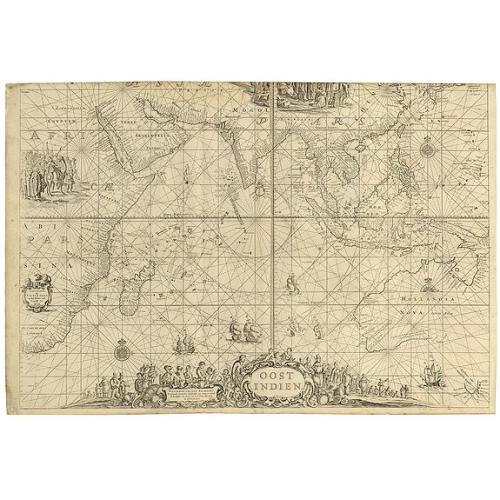
OOST INDIEN Wassende-Graade Paskaart, vertoonende nevens het Oosterlykste van Afrika, meede de Zeekusten van Asia, van C. de Bona Esperance tot Eso, boven Japan. . . |
||||||||||||||||||||
|
||||||||||||||||||||
|
|
||||||||||||||||||||
|
Selling price: $ Please login to see price!
Sold in 2010 Missed this item! Add your name to our mailing list and be the first to get notified about our newly added listings. . |
My Collection + - Save and collect this or any of your favorite items in one place.
If you want to save the items permanently, please sign in or create account first. |
|||||||||||||||||||
Description
(Sea chart of the East Indies on Mercator projection delineating not only the eastern coast of Africa, but also the coasts of Asia, from the C. of Good Hope till Eso, north of Japan. 't Amsterdam, by Pieter Goos op het Water inde Vergulde Zee-Spiegel. seyn nu te Bekoomen by Johannes van Kuelen.)
Naming all the Dutch discoveries in Australia, from the first landfall in 1616 and culminating in Abel Tasman's extremely important voyage of 1642-1644.
Very rare chart of the territory where the Dutch East India Company V.O.C. was active, from the east of Africa till the western and southern coasts of Australia. These charts were published in the Netherlands for use at sea and the Dutch vessels sailing to and from the Indies were equipped with these charts. Being an important mean for navigation they had to be kept up to date using the latest possible information. Being used on board ship they where due to parish easily and the remaining number of copies is therefor very small.
Engraved sea chart printed on ply-paper.
Interestingly the chart has a misspelling of the name : van Kuelen in stead of van Keulen. This fact is only mentioned by prof. Gunter Schilder in The van Keulen Carthography, Appendix 5, 211, page 186, he however does not mention the additional soundings and text in West Australia.
A most embellished map of the East Indies, showing the coastline of Australia as established by Abel Tasman in 1644.
This chart was first published by Pieter Goos c. 1660. Schilder notes that "this map contains a complete survey of Dutch expansion in the East Indies and takes into account Tasman's two voyages of exploration".
The plates for this and other of Goos's charts passed to Johannes van Keulen, the pre-eminent Dutch maritime publisher of the next generation, who sometimes included these oversize charts in his sea-atlases, which would account for the careless trimming to the upper border.
This copy is however is less trimmed than the Goos version sold recently in the Sothebys Sale rooms.
Beside this the following text is added where we find present-day Perth : Duinig land boven Lage Ruigte Gelijk Verdronk Boomen en Boschaghe a text also used by Hessel Gerritsz, but only now inserted.
The update of the soundings was very important as many Dutch ships were shipwrecked at the West Australian coast.
The VOC flagship Batavia (1629), under the command of Commander Francois Pelsaert, was wrecked on the Abrolhos Islands, just 60 kilometers off the coast of Geraldton, Western Australia.
The Ridderschap van Holland (1694) was shipwrecked on the west coast, probably on the Abrolhos Islands. The VOC dispatched a fleet under Willem Vlamingh to search for survivors. There were none found. Could it be that Van Keulen added after this event the soundings to his chart ! ?
An advertisement of sea atlases, pilot books, charts, etc. sold by Joh. van Keulen, printed in the "Zee-Alas" of 1695 is known and mentions "als meede vier groote Paskaarten op Perkement, die voor desen Pieter Goos totsijn gebruyk gehad heeft, te weten OostIndien Wassende graden, ... (See Atlantes Neerlandici, Volume 4, page 278, Y). In fact charts of this format printed on paper are much rarer than those printed on vellum.
The charts printed on paper are sometimes added to "made to order" copies of the "Zee Fakkel".
Interestingly the re-issued Goos/van Keulen charts were used on ships of the British and French East India Company, as late as the 1740.
This is a chart that only infrequently appears for sale.
Reference: Schilder, Australia Unveiled, p.202 (pl.XLIV, the Goos state). Tooley, Mapping of Australia, 792.
FAQ - Guarantee - Shipping
Buying in the BuyNow Gallery
This item is available for immediate purchase when a "Add to Cart" or "Inquire Now" button is shown.
Items are sold in the EU margin scheme
Payments are accepted in Euros or US Dollars.
Authenticity Guarantee
 We provide professional descriptions, condition report (based on 45 years experience in the map business)
Paulus Swaen warrants the authenticity of our items and a certificate of authenticity is provided for each acquired lot.
Condition and Coloring
We indicate the condition of each item and use our unnique HiBCoR grading system in which four key items determine a map's value: Historical Importance, Beauty, Condition/Coloring and Rarity.
Color Key
We offer many maps in their original black and white condition. We do not systematically color-up maps to make them more sellable to the general public or buyer.
Copper engraved or wood block maps are always hand colored. Maps were initially colored for aesthetic reasons and to improve readability. Nowadays, it is becoming a challenge to find maps in their original colors and are therefor more valuable.
We use the following color keys in our catalog:
Original colors; mean that the colors have been applied around the time the map was issued.
Original o/l colors; means the map has only the borders colored at the time of publication.
Colored; If the colors are applied recently or at the end of the 20th century.
Read more about coloring of maps [+]
Shipping fee
A flat shipping fee of $ 30 is added to each shipment by DHL within Europe and North America. This covers : International Priority shipping, Packing and Insurance (up to the invoice amount).
Shipments to Asia are $ 40 and rest of the world $50
We charge only one shipping fee when you have been successful on multiple items or when you want to combine gallery and auction purchases.
Read more about invoicing and shipping
FAQ
Please have a look for more information about buying in the BuyNow gallery
Many answers are likely to find in the general help section.
My Collection+
![]()
With My Collection+ you can collect all your favorite items in one place. It is free, and anyone can create his or her virtual collection.
Unless you are logged in, the item is only saved for this session. You have to be registed and logged-in if you want to save this item permanently to My Collection+.
Read More[+]
Register here, it is free and you do not need a credit card.
Add this item to
My Collection+
or click the following link to see My Collection+.
| Digital Image Download | |
|
Paulus Swaen maintains an archive of most of our high-resolution rare maps, prints, posters and medieval manuscript scans. We make them freely available for download and study. Read more about free image download |
Click the image for a free small image download. |
In accordance with the EU Consumer Rights Directive and habitually reside in the European Union you have the right to cancel the contract for the purchase of a lot, without giving any reason.
The cancellation period will expire 14 calendar days from the day after the date on which you or a third party (other than the carrier and indicated by you) acquires, physical possession of the lot. To exercise the right to cancel you must inform Paulus Swaen Inc, of your decision to cancel this contract by a clear statement (e.g. a letter sent by post, or e-mail (amsterdam@swaen.com).
To meet the cancellation deadline, it is sufficient for you to send your communication concerning your exercise of the right to cancel before the cancellation period has expired.
