Subscribe to be notified if similar examples become available.
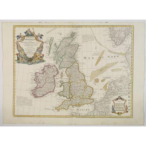
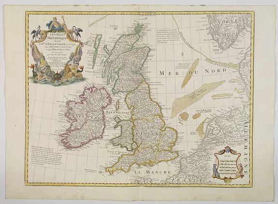
Les Isles Britanniques ou sont le Rme. D'Angleterre . . . Par G. De L'Isle. . . A Paris Chez Dezauche. . . |
||||||||||||||||||||
|
||||||||||||||||||||
|
|
||||||||||||||||||||
Description
A map of the British Isles prepared by De L'Isle and published by Dezauche / Buache. The bottom right shows the coasts of the Netherlands, Belgium, and northern France and at the upper right is the southern tip of Norway.
The large title cartouche incorporates figures and sea monsters and is surmounted by Neptune. In the lower right corner another cartouche containing five distance scales.
Philippe Buache de la Neuville was born in Neuville-en-Pont (France) on 7th February 1700 and studied at the Académie des Sciences, where he won the first prize for architecture in 1721.
He subsequently joined the Ministry of the Navy, where his drafting skills enabled him to concentrate on cartography. In 1729 he became geographer to the king, then geographer in the Académie des Sciences, successor to his former teacher and father-in-law, Guillaume Delisle (1675-1726). He pioneered a new form of theoretical geography and, in 1755, was appointed Professor of Geography.
More than a copyist, Buache was an academic geographer who researched his material thoroughly, relying on the most up-to-date information from voyages of discovery. He was the first geographer to recognize the important concept of the watershed and it was this that led him to make a number of deductions, some correct, some not.
Buache was trained under the geographer Guillaume Delisle, whose daughter he married, and whom he succeeded in the Académie des sciences in 1730. Buache was nominated first geographer of the king in 1729. He established the division of the world by seas and river systems. He believed in a southern continent, an hypothesis which was confirmed by later discoveries. In 1754, he published an "Atlas physique."
His nephew, Jean Nicolas Bauche (born La Neuville-au-Pont, 15 February 1741 and died Paris, 21 November 1825), continued his business and was also a geographer of the king.
FAQ - Guarantee - Shipping
Buying in the BuyNow Gallery
This item is available for immediate purchase when a "Add to Cart" or "Inquire Now" button is shown.
Payments are accepted in Euros or US Dollars. We accept most major credit cards, PayPal and bank transfer.
Authenticity Guarantee
 We provide professional descriptions, condition report and HiBCoR rating (based on 45 years experience in the map business)
We fully guarantee the authenticity of items we sell. We provide a certificate of authenticity for each purchased item.
Condition / Coloring
We indicate the condition of each item and use our unnique HiBCoR grading system in which four key items determine a map's value: Historical Importance, Beauty, Condition/Coloring and Rarity.
We offer many maps in their original black and white condition. We do not systematically color-up maps to make them more sellable to the general public or buyer.
Copper engraved or wood block maps are always hand colored. Maps were initially colored for aesthetic reasons and to improve readability. Nowadays, it is becoming a challenge to find maps in their original colors and are therefor more valuable.
We use the following color keys in our catalog:
Original colors; mean that the colors have been applied around the time the map was issued.
Colored; If the colors are applied recently or at the end of the 20th century, then "colored", or "attractive colors" will be used.
Original o/l colors; means the map has only the borders colored at the time of publication.
Read more about coloring of maps [+]
FAQ
Please have a look for more information about buying in the BuyNow gallery.
Many answers are likely to find in the general help section.
Virtual Collection
![]()
With Virtual Collection you can collect all your favorite items in one place. It is free, and anyone can create his or her Virtual map collection.
Unless you are logged in, the item is only saved for this session. You have to be registed and logged-in if you want to save this item permanently to your Virtual Collection.
Read More [+]
If you want to save the items permanently, please sign in
or create account first. ![]()
Registering Here, it is and you do not need a credit card.
Add this item to
Virtual Collection
or click the following link to see my Virtual Collection.
Invoice
The invoice and certificates of authenticity are available in the client center >Invoices
| Digital Image Download | |
|
Paulus Swaen maintains an archive of most of our high-resolution rare maps, prints, posters and medieval manuscript scans. We make them freely available for download and study. Read more about free image download |
Click the image for a free small image download. |
In accordance with the EU Consumer Rights Directive and habitually reside in the European Union you have the right to cancel the contract for the purchase of a lot, without giving any reason.
The cancellation period will expire 14 calendar days from the day after the date on which you or a third party (other than the carrier and indicated by you) acquires, physical possession of the lot. To exercise the right to cancel you must inform Paulus Swaen Inc, of your decision to cancel this contract by a clear statement (e.g. a letter sent by post, or e-mail (amsterdam@swaen.com).
To meet the cancellation deadline, it is sufficient for you to send your communication concerning your exercise of the right to cancel before the cancellation period has expired.
