Subscribe to be notified if similar examples become available.
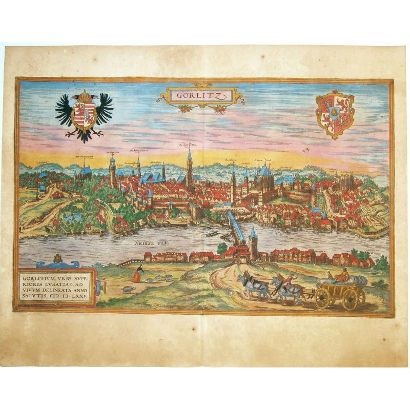
Gorlitz - Gorlitium, Urbs Superioris Lusatiae, ad vivum delineata, Anno Salutis MDLXXV. |
||||||||||||||||||||
|
||||||||||||||||||||
|
|
||||||||||||||||||||
|
Selling price: $ Please login to see price!
Sold in 2021 Missed this item! Add your name to our mailing list and be the first to get notified about our newly added listings. . |
My Collection + - Save and collect this or any of your favorite items in one place.
If you want to save the items permanently, please sign in or create account first. |
|||||||||||||||||||
Description
A fine antique copper engraved panoramic view of Gorlitz by Braun and Hogenberg, with local costumes in the foreground. Today the Neisse river serves as border between Germany and Poland, so in the foreground what's shown is the polish town of Zgorzelec, and in the background the german town of Görlitz. From: Civitates Orbis Terrarum, ... Part 2, 1575.
TRANSLATION OF CARTOUCHE TEXT: Görlitz, city in Upper Lusatia, drawn true to nature in 1575.
COMMENTARY BY BRAUN: "Görlitz is a splendid city in Upper Lusatia; it is adorned with many very beautiful buildings and well fortified with walls and moats, but the ground on which it lies is uneven and mountainous.
The River Neisse flows through the city, which is of great advantage to the millers, brewers, dyers and other artisans. Spanning this river is a great wooden bridge covered with a roof."
Görlitz is shown from the east looking across the Neisse; the impressive silhouette of this city on the bank of the river is reproduced in detail, with its many church spires and magnificent half-timbered houses. On the right above the wooden bridge over the Neisse, which was roofed over in 1566, the city's landmark can be seen, the mighty late Gothic hall church of SS Peter and Paul, on the left the tall town hall and watchtower.
The town prospered due to its location on an important trade route and received a municipal charter around 1200. It was granted the right to brew beer, the right to mint and issue coins, and staple rights for the woad plant (German indigo, principally used to produce blue linen), and reached the height of its political and economic power at the beginning of the 15th century (Taschen).
Copper engraving, made after a woodcut by Georg Scharfenberg, after the drawing by Joseph Metzker, 1565.
The 'Civitates Orbis Terrarum', or the "Braun & Hogenberg", is a six-volume town atlas and the greatest book of town views and plans ever published: 363 engravings, sometimes beautifully colored. It was one of the best-selling works in the last quarter of the 16th century.
Georg Braun wrote the text accompanying the plans and views on the verso. A large number of the plates were engraved after the original drawings of Joris Hoefnagel (1542-1600), who was a professional artist.
The first volume was published in Latin in 1572, the sixth volume in 1617. Frans Hogenberg created the tables for volumes I through IV, and Simon van den Neuwel created those for volumes V and VI. Other contributors were cartographer Daniel Freese, and Heinrich Rantzau. Works by Jacob van Deventer, Sebastian Münster, and Johannes Stumpf were also used. Translations appeared in German and French.
Reference: Van der Krogt 4, 1579; Taschen, Braun and Hogenberg, p.182.
FAQ - Guarantee - Shipping
Buying in the BuyNow Gallery
This item is available for immediate purchase when a "Add to Cart" or "Inquire Now" button is shown.
Items are sold in the EU margin scheme
Payments are accepted in Euros or US Dollars.
Authenticity Guarantee
 We provide professional descriptions, condition report (based on 45 years experience in the map business)
Paulus Swaen warrants the authenticity of our items and a certificate of authenticity is provided for each acquired lot.
Condition and Coloring
We indicate the condition of each item and use our unnique HiBCoR grading system in which four key items determine a map's value: Historical Importance, Beauty, Condition/Coloring and Rarity.
Color Key
We offer many maps in their original black and white condition. We do not systematically color-up maps to make them more sellable to the general public or buyer.
Copper engraved or wood block maps are always hand colored. Maps were initially colored for aesthetic reasons and to improve readability. Nowadays, it is becoming a challenge to find maps in their original colors and are therefor more valuable.
We use the following color keys in our catalog:
Original colors; mean that the colors have been applied around the time the map was issued.
Original o/l colors; means the map has only the borders colored at the time of publication.
Colored; If the colors are applied recently or at the end of the 20th century.
Read more about coloring of maps [+]
Shipping fee
A flat shipping fee of $ 30 is added to each shipment by DHL within Europe and North America. This covers : International Priority shipping, Packing and Insurance (up to the invoice amount).
Shipments to Asia are $ 40 and rest of the world $50
We charge only one shipping fee when you have been successful on multiple items or when you want to combine gallery and auction purchases.
Read more about invoicing and shipping
FAQ
Please have a look for more information about buying in the BuyNow gallery
Many answers are likely to find in the general help section.
My Collection+
![]()
With My Collection+ you can collect all your favorite items in one place. It is free, and anyone can create his or her virtual collection.
Unless you are logged in, the item is only saved for this session. You have to be registed and logged-in if you want to save this item permanently to My Collection+.
Read More[+]
Register here, it is free and you do not need a credit card.
Add this item to
My Collection+
or click the following link to see My Collection+.
| Digital Image Download | |
|
Paulus Swaen maintains an archive of most of our high-resolution rare maps, prints, posters and medieval manuscript scans. We make them freely available for download and study. Read more about free image download |
Click the image for a free small image download. |
In accordance with the EU Consumer Rights Directive and habitually reside in the European Union you have the right to cancel the contract for the purchase of a lot, without giving any reason.
The cancellation period will expire 14 calendar days from the day after the date on which you or a third party (other than the carrier and indicated by you) acquires, physical possession of the lot. To exercise the right to cancel you must inform Paulus Swaen Inc, of your decision to cancel this contract by a clear statement (e.g. a letter sent by post, or e-mail (amsterdam@swaen.com).
To meet the cancellation deadline, it is sufficient for you to send your communication concerning your exercise of the right to cancel before the cancellation period has expired.
