Subscribe to be notified if similar examples become available.
Geography A Map of the World in three Sections, Describing the Polar Regions to the Tropic's. . . |
||||||||||||||||||||
|
||||||||||||||||||||
|
|
||||||||||||||||||||
Description
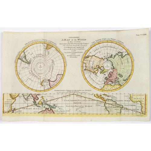
This three part world map featured in the first American edition of the Encyclopedia Britannica, published by Thomas Dobson in Philadelphia from 1789 to 1798. It shows the world divided in three: the North and South Pole on Polar projections, along with a projection of the Torrid of Tropical regions along the bottom. A multi-part projection like this is rare, as is a map from the American edition.
The South Pole projection is seen on the left, showing the region radiating around the pole to the Tropic of Capricorn. The tips of both South America and Africa just project out from the rim, while New Holland and New Zealand are also named.
At the very centre of the projection, however, there is nothing except for the criss-crossing tracks of ships, those of the Resolution and Adventure. In the middle of the ships' transits is only a "Southern Icy Ocean."
The North Pole projection is dominated much more by land, with a large portion of North America, Europe, and Asia showing, along with North Africa. However, like the South, the pole itself is covered only with a "Northern Icy Ocean".
Running beneath is a projection showing the latitudes missing from the polar projections, the "Torrid Zone or Tropical Regions of the World". The Pacific Ocean is placed rather unusually at the centre, perhaps better to highlight the "New discoveries in the Pacific Ocean or South Sea." The map's purpose is to show the achievements of recent exploration.
Reference: Robert D. Arner, Dobson's Encyclopaedia: The Publisher, Text, and Publication of America's First Britannica, 1789-1803 (Philadelphia: University of Pennsylvania Press, 1991)
It shows the world divided in three: the North and South Pole on Polar projections, along with a projection of the Torrid of Tropical regions along the bottom. A multi-part projection like this is rare, as is a map from the American edition.
The South Pole projection is seen on the left, showing the region radiating around the pole to the Tropic of Capricorn. The tips of both South America and Africa just project out from the rim, while New Holland and New Zealand are also named.
At the very centre of the projection, however, there is nothing except for the criss-crossing tracks of ships, those of the Resolution and Adventure. In the middle of the ships' transits is only a "Southern Icy Ocean."
The North Pole projection is dominated much more by land, with a large portion of North America, Europe, and Asia showing, along with North Africa. However, like the South, the pole itself is covered only with a "Northern Icy Ocean".
Running beneath is a projection showing the latitudes missing from the polar projections, the "Torrid Zone or Tropical Regions of the World". The Pacific Ocean is placed rather unusually at the centre, perhaps better to highlight the "New discoveries in the Pacific Ocean or South Sea." The map's purpose is to show the achievements of recent exploration.
Reference: Robert D. Arner, Dobson's Encyclopaedia: The Publisher, Text, and Publication of America's First Britannica, 1789-1803 (Philadelphia: University of Pennsylvania Press, 1991)
FAQ - Guarantee - Shipping
Buying in the BuyNow Gallery
This item is available for immediate purchase when a "Add to Cart" or "Inquire Now" button is shown.
Payments are accepted in Euros or US Dollars. We accept most major credit cards, PayPal and bank transfer.
Authenticity Guarantee
 We provide professional descriptions, condition report and HiBCoR rating (based on 45 years experience in the map business)
We fully guarantee the authenticity of items we sell. We provide a certificate of authenticity for each purchased item.
Condition / Coloring
We indicate the condition of each item and use our unnique HiBCoR grading system in which four key items determine a map's value: Historical Importance, Beauty, Condition/Coloring and Rarity.
We offer many maps in their original black and white condition. We do not systematically color-up maps to make them more sellable to the general public or buyer.
Copper engraved or wood block maps are always hand colored. Maps were initially colored for aesthetic reasons and to improve readability. Nowadays, it is becoming a challenge to find maps in their original colors and are therefor more valuable.
We use the following color keys in our catalog:
Original colors; mean that the colors have been applied around the time the map was issued.
Colored; If the colors are applied recently or at the end of the 20th century, then "colored", or "attractive colors" will be used.
Original o/l colors; means the map has only the borders colored at the time of publication.
Read more about coloring of maps [+]
FAQ
Please have a look for more information about buying in the BuyNow gallery.
Many answers are likely to find in the general help section.
Virtual Collection
![]()
With Virtual Collection you can collect all your favorite items in one place. It is free, and anyone can create his or her Virtual map collection.
Unless you are logged in, the item is only saved for this session. You have to be registed and logged-in if you want to save this item permanently to your Virtual Collection.
Read More [+]
If you want to save the items permanently, please sign in
or create account first. ![]()
Registering Here, it is and you do not need a credit card.
Add this item to
Virtual Collection
or click the following link to see my Virtual Collection.
Invoice
The invoice and certificates of authenticity are available in the client center >Invoices
| Digital Image Download | |
|
Paulus Swaen maintains an archive of most of our high-resolution rare maps, prints, posters and medieval manuscript scans. We make them freely available for download and study. Read more about free image download |
Click the image for a free small image download. |

In accordance with the EU Consumer Rights Directive and habitually reside in the European Union you have the right to cancel the contract for the purchase of a lot, without giving any reason.
The cancellation period will expire 14 calendar days from the day after the date on which you or a third party (other than the carrier and indicated by you) acquires, physical possession of the lot. To exercise the right to cancel you must inform Paulus Swaen Inc, of your decision to cancel this contract by a clear statement (e.g. a letter sent by post, or e-mail (amsterdam@swaen.com).
To meet the cancellation deadline, it is sufficient for you to send your communication concerning your exercise of the right to cancel before the cancellation period has expired.
