Subscribe to be notified if similar examples become available.
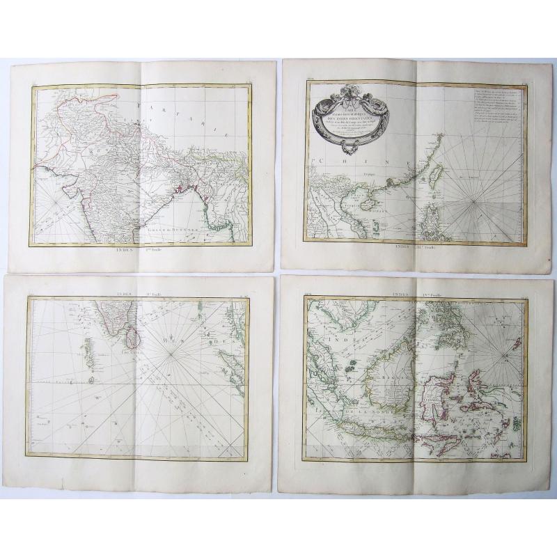
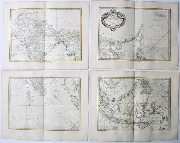
EAST INDIES,- Carte Hydro-geo-graphique des Indes Orientales.. (Set of Four Maps). |
||||||||||||||||||||
|
||||||||||||||||||||
|
|
||||||||||||||||||||
Estimated value: $450 - $650 |
My Collection +
Add this or any of your favorite items in one place. If you want to save the items permanently, you have to sign in or create an account first. |
|||||||||||||||||||
Description
A detailed map with a large, and very decorative title cartouche, showing the coast of southern China [incl. the island of Hong Kong, also not labeled], Taiwan and the Philippines region with particular detail in the Tonkin area of northern Vietnam. The map has rhumb lines and depths to help navigators.
The four sheets can be united to form a large map of approx. 580mm x 820mm
Published in: 'Atlas moderne ou collection de cartes sur toutes les parties du globe terrestre par plusieurs auteurs'. One of the earliest detailed hydrographic maps of South East Asia.
Rigobert Bonne (1727-1794) was a French geographer, hydrographer engineer, and cartographer master of mathematics in the 18th century. Born in the Ardennes at Raucourt on October 6, 1727, he learned mathematics without a teacher and was an engineer at the age of eighteen. He served in that capacity in the Flanders War, where he was at the siege of Berg-op-Zoom in 1747.
He applied himself to physics, mathematics, geography, and for fifteen years he was one of the most sought-after masters in Paris. In 1775, he succeeded Giovanni Rizzi-Zannoni as the cartographer to the King of France in the Hydrographic Service of the Navy (the Depot of maps and plans of the Navy was created by order of King Louis XV in 1720).
An attack of paralysis which occurred to him in 1775, of which he remained in infirmity for the rest of his life. Around 1780, he precisely defined the projection which would then bear his name: the Projection of Bonne. Among other things, he produced maps for the works of Father Raynal and for the 'Methodical Encyclopedia' by Nicolas Desmarest. (Wikipedia)
FAQ - Guarantee - Shipping
994 BuyBidBuying in the BuyNow Gallery
This item is available for immediate purchase when a "Add to Cart" or "Inquire Now" button is shown.
Payments are accepted in Euros or US Dollars. We accept most major credit cards, PayPal and bank transfer.
Authenticity Guarantee
 We provide professional descriptions, condition report and HiBCoR rating (based on 45 years experience in the map business)
We fully guarantee the authenticity of items we sell. We provide a certificate of authenticity for each purchased item.
Condition / Coloring
We indicate the condition of each item and use our unnique HiBCoR grading system in which four key items determine a map's value: Historical Importance, Beauty, Condition/Coloring and Rarity.
We offer many maps in their original black and white condition. We do not systematically color-up maps to make them more sellable to the general public or buyer.
Copper engraved or wood block maps are always hand colored. Maps were initially colored for aesthetic reasons and to improve readability. Nowadays, it is becoming a challenge to find maps in their original colors and are therefor more valuable.
We use the following color keys in our catalog:
Original colors; mean that the colors have been applied around the time the map was issued.
Colored; If the colors are applied recently or at the end of the 20th century, then "colored", or "attractive colors" will be used.
Original o/l colors; means the map has only the borders colored at the time of publication.
Read more about coloring of maps [+]
FAQ
Please have a look for more information about buying in the BuyNow gallery.
Many answers are likely to find in the general help section.
My Collection+
![]()
With My Collection+ you can collect all your favorite items in one place. It is free, and anyone can create his or her virtual map collection.
Unless you are logged in, the item is only saved for this session. You have to be registed and logged-in if you want to save this item permanently to My Collection+.
Read More [+]
If you want to save the items permanently, please sign in
or create account first. ![]()
Registering Here, it is and you do not need a credit card.
Add this item to
My Collection+
or click the following link to see My Collection+.
Invoice
The invoice and certificates of authenticity are available in the client center >Invoices
| Digital Image Download | |
|
Paulus Swaen maintains an archive of most of our high-resolution rare maps, prints, posters and medieval manuscript scans. We make them freely available for download and study. Read more about free image download |
Click the image for a free small image download. |
In accordance with the EU Consumer Rights Directive and habitually reside in the European Union you have the right to cancel the contract for the purchase of a lot, without giving any reason.
The cancellation period will expire 14 calendar days from the day after the date on which you or a third party (other than the carrier and indicated by you) acquires, physical possession of the lot. To exercise the right to cancel you must inform Paulus Swaen Inc, of your decision to cancel this contract by a clear statement (e.g. a letter sent by post, or e-mail.
To meet the cancellation deadline, it is sufficient for you to send your communication concerning your exercise of the right to cancel before the cancellation period has expired.
