Subscribe to be notified if similar examples become available.
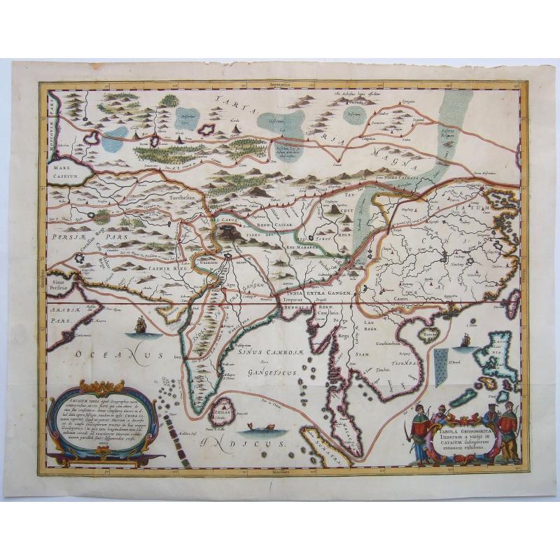
China, Historic travel routes to,- TABULA GEODOBORICA Itinerum a variis in CATAIUM susceptorum rationum exhibens |
||||||||||||||||||||
|
||||||||||||||||||||
|
|
||||||||||||||||||||
Estimated value: $370 - $540 |
My Collection +
Add this or any of your favorite items in one place. If you want to save the items permanently, you have to sign in or create an account first. |
|||||||||||||||||||
Description
Antique copper engraved map of Asia, from Persia to China, illustrating various routes of travel across the continent - Marco Polo, Jesuits, etc. The map was published in Kircher's 'China Illustrata' in 1667.
This fascinating map covers an immense area and depicts at least four routes available to Europeans for eastern travel during the 17th century. The northernmost originates north of an irregularly shaped Caspian Sea and meanders through the region historically known as Tartary before ending at the Great Wall. The southernmost route starts in the Persian Gulf and makes land near Mumbai, before proceeding overland into the mountains of Nepal. A sea route through the Strait of Malacca, and other overland routes through India, China, and Myanmar are also shown.
In addition to transportation routes, interesting topographical details such as mountains and deserts are shown alongside locations of cities, rivers, and even yurts in the northern steppes – all items of importance to a possible traveler or armchair geographer.
The map was probably engraved by someone working for Johannes Janssonius.
Athanasius Kircher was a German Jesuit scholar and polymath who published around 40 major works, most notably in the fields of comparative religion, geology, and medicine. Kircher has been compared to fellow Jesuit Roger Joseph Boscovich and to Leonardo da Vinci for his enormous range of interests, and has been honored with the title "Master of a Hundred Arts". He taught for more than 40 years at the Roman College, where he set up a wunderkammer. A resurgence of interest in Kircher has occurred within the scholarly community in recent decades.
Kircher claimed to have deciphered the hieroglyphic writing of the ancient Egyptian language, but most of his assumptions and translations in this field were later found to be incorrect. He did, however, correctly establish the link between the ancient Egyptian and the Coptic languages, and some commentators regard him as the founder of Egyptology. Kircher was also fascinated with Sinology and wrote an encyclopedia of China, in which he noted the early presence there of Nestorian Christians while also attempting to establish links with Egypt and Christianity.....Edward W. Schmidt, referred to Kircher as "the last Renaissance man".
In 'A Man of Misconceptions', his 2012 book about Kircher, John Glassie writes that while "many of Kircher's actual ideas today seem wildly off-base, if not simply bizarre," he was "a champion of wonder, a man of awe-inspiring erudition and inventiveness," whose work was read "by the smartest minds of the time.".... [from Wikipedia.]
FAQ - Guarantee - Shipping
994 BuyBidBuying in the BuyNow Gallery
This item is available for immediate purchase when a "Add to Cart" or "Inquire Now" button is shown.
Payments are accepted in Euros or US Dollars. We accept most major credit cards, PayPal and bank transfer.
Authenticity Guarantee
 We provide professional descriptions, condition report and HiBCoR rating (based on 45 years experience in the map business)
We fully guarantee the authenticity of items we sell. We provide a certificate of authenticity for each purchased item.
Condition / Coloring
We indicate the condition of each item and use our unnique HiBCoR grading system in which four key items determine a map's value: Historical Importance, Beauty, Condition/Coloring and Rarity.
We offer many maps in their original black and white condition. We do not systematically color-up maps to make them more sellable to the general public or buyer.
Copper engraved or wood block maps are always hand colored. Maps were initially colored for aesthetic reasons and to improve readability. Nowadays, it is becoming a challenge to find maps in their original colors and are therefor more valuable.
We use the following color keys in our catalog:
Original colors; mean that the colors have been applied around the time the map was issued.
Colored; If the colors are applied recently or at the end of the 20th century, then "colored", or "attractive colors" will be used.
Original o/l colors; means the map has only the borders colored at the time of publication.
Read more about coloring of maps [+]
FAQ
Please have a look for more information about buying in the BuyNow gallery.
Many answers are likely to find in the general help section.
My Collection+
![]()
With My Collection+ you can collect all your favorite items in one place. It is free, and anyone can create his or her virtual map collection.
Unless you are logged in, the item is only saved for this session. You have to be registed and logged-in if you want to save this item permanently to My Collection+.
Read More [+]
If you want to save the items permanently, please sign in
or create account first. ![]()
Registering Here, it is and you do not need a credit card.
Add this item to
My Collection+
or click the following link to see My Collection+.
Invoice
The invoice and certificates of authenticity are available in the client center >Invoices
| Digital Image Download | |
|
Paulus Swaen maintains an archive of most of our high-resolution rare maps, prints, posters and medieval manuscript scans. We make them freely available for download and study. Read more about free image download |
Click the image for a free small image download. |
In accordance with the EU Consumer Rights Directive and habitually reside in the European Union you have the right to cancel the contract for the purchase of a lot, without giving any reason.
The cancellation period will expire 14 calendar days from the day after the date on which you or a third party (other than the carrier and indicated by you) acquires, physical possession of the lot. To exercise the right to cancel you must inform Paulus Swaen Inc, of your decision to cancel this contract by a clear statement (e.g. a letter sent by post, or e-mail.
To meet the cancellation deadline, it is sufficient for you to send your communication concerning your exercise of the right to cancel before the cancellation period has expired.
