Subscribe to be notified if similar examples become available.
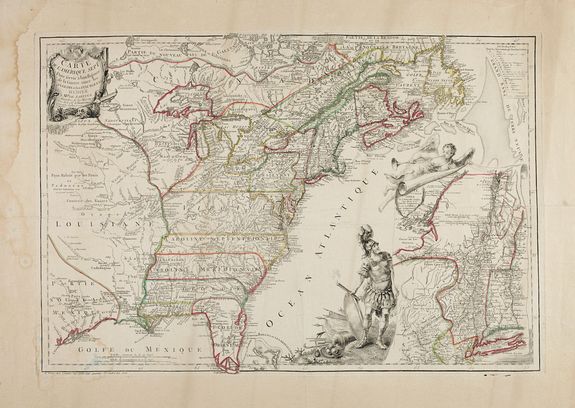
Carte de l'Amerique Septle. Pour Servir a l'intelligence de la Guerre entre les Anglois et les Insurgents... |
||||||||||||||||||||
|
||||||||||||||||||||
|
|
||||||||||||||||||||
|
Selling price: $ Please login to see price!
Sold in 2022 Missed this item! Add your name to our mailing list and be the first to get notified about our newly added listings. . |
My Collection + - Save and collect this or any of your favorite items in one place.
If you want to save the items permanently, please sign in or create account first.
Watchers:
7
|
|||||||||||||||||||
Description
Second state of this extremely rare separate publication. This separately issued map is one of the most beautiful of the thirteen American Colonies from the Revolutionary War period. It is also one of the earliest continental maps to focus on the conflict. The Chevalier de Beaurain was Royal Geographer to Louis XVI. At the time, France was secretly aiding the colonies, and the map was intended as a propaganda document to prepare the public for the moment when it would become propitious for France to enter the war on the American side. That moment came in early 1778, shortly after the British defeat at Saratoga.
Beaurain used John Mitchell's famous map of 1755 as a base map, and shows all of North America as far west as the Great Plains. But he has modified and updated Mitchell's political boundaries. The Southern English colonies no longer extend indefinitely to the west, but now have their western boundaries at the Mississippi River. The new Canadian province of Quebec, founded in the 1760s, has been added in, and numerous changes and additions have been made in the Midwest and deep South. The large and very decorative inset at lower right gives a detailed close-up look at the Mid-Atlantic colonies.
The entire map is heavily ornamented, with a rococo title cartouche at upper-left, and a lavish depiction of Mars, the God of War, watching Fame proclaim the new country.
The map is known in three states, which can be identified as follows :
- State 1: Title of the inset reads: Carte de la Nouvelle York d'une partie de la Nouvelle Angleterre et de la Pensilvany.
- State 2: Inset title has been altered to read Carte de Nouvelle York de la Nouvelle Jersey, d'une Partie de la Nouvelle Angleterre de celle Pensilvany du Maryland et de la Virginy.
- State 3: A folding flap has been pasted to the lower margin of the inset, which extends the geography south to Chesapeake Bay.
This copy is in second state : There are substantial changes between the first state and the second state. Lake Champlain is significantly revised, most notably in the south, as is Lake George. The upper Hudson River is also significantly revised above Albany. In the inset, there are dozens of new place names added.
Reference: Sellers and Van Ee #149, McCorkle, B.B. (New England) 777.3.
FAQ - Guarantee - Shipping
Buying in the BuyNow Gallery
This item is available for immediate purchase when a "Add to Cart" or "Inquire Now" button is shown.
Items are sold in the EU margin scheme
Payments are accepted in Euros or US Dollars.
Authenticity Guarantee
 We provide professional descriptions, condition report (based on 45 years experience in the map business)
Paulus Swaen warrants the authenticity of our items and a certificate of authenticity is provided for each acquired lot.
Condition and Coloring
We indicate the condition of each item and use our unnique HiBCoR grading system in which four key items determine a map's value: Historical Importance, Beauty, Condition/Coloring and Rarity.
Color Key
We offer many maps in their original black and white condition. We do not systematically color-up maps to make them more sellable to the general public or buyer.
Copper engraved or wood block maps are always hand colored. Maps were initially colored for aesthetic reasons and to improve readability. Nowadays, it is becoming a challenge to find maps in their original colors and are therefor more valuable.
We use the following color keys in our catalog:
Original colors; mean that the colors have been applied around the time the map was issued.
Original o/l colors; means the map has only the borders colored at the time of publication.
Colored; If the colors are applied recently or at the end of the 20th century.
Read more about coloring of maps [+]
Shipping fee
A flat shipping fee of $ 30 is added to each shipment by DHL within Europe and North America. This covers : International Priority shipping, Packing and Insurance (up to the invoice amount).
Shipments to Asia are $ 40 and rest of the world $50
We charge only one shipping fee when you have been successful on multiple items or when you want to combine gallery and auction purchases.
Read more about invoicing and shipping
FAQ
Please have a look for more information about buying in the BuyNow gallery
Many answers are likely to find in the general help section.
My Collection+
![]()
With My Collection+ you can collect all your favorite items in one place. It is free, and anyone can create his or her virtual collection.
Unless you are logged in, the item is only saved for this session. You have to be registed and logged-in if you want to save this item permanently to My Collection+.
Read More[+]
Register here, it is free and you do not need a credit card.
Add this item to
My Collection+
or click the following link to see My Collection+.
| Digital Image Download | |
|
Paulus Swaen maintains an archive of most of our high-resolution rare maps, prints, posters and medieval manuscript scans. We make them freely available for download and study. Read more about free image download |
Click the image for a free small image download. |
In accordance with the EU Consumer Rights Directive and habitually reside in the European Union you have the right to cancel the contract for the purchase of a lot, without giving any reason.
The cancellation period will expire 14 calendar days from the day after the date on which you or a third party (other than the carrier and indicated by you) acquires, physical possession of the lot. To exercise the right to cancel you must inform Paulus Swaen Inc, of your decision to cancel this contract by a clear statement (e.g. a letter sent by post, or e-mail (amsterdam@swaen.com).
To meet the cancellation deadline, it is sufficient for you to send your communication concerning your exercise of the right to cancel before the cancellation period has expired.
