Please login to see price!.
Subscribe to be notified if similar examples become available.
Candia [on sheet with] La Cita de Corphu. |
||||||||||||||||||||
|
||||||||||||||||||||
|
|
||||||||||||||||||||
|
Selling price: $...
Please login to see price! Sold in 2021 Missed this item! Add your name to our mailing list and be the first to get notified about our newly added listings. . |
Collection - Save and collect this or any of your favorite items in one place.
If you want to save the items permanently, please sign in or create account first. |
|||||||||||||||||||
Description
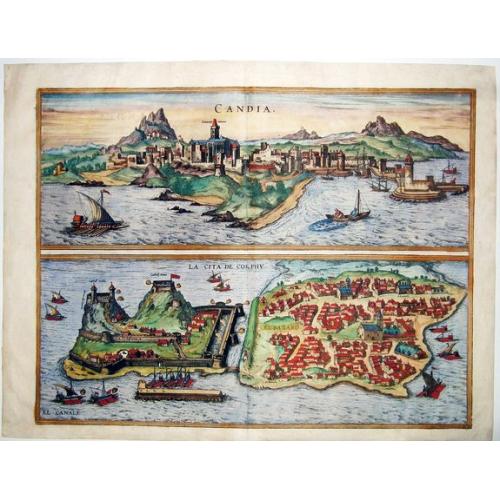
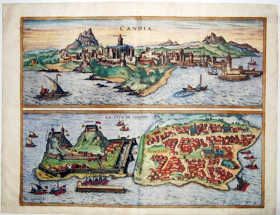
A pair of copper engraved views of the Venetian cities of Iraklion, Crete, and Corfu from the second volume of Braun & Hogenberg's "Civitas Orbis Terrarum."
The upper view shows Iraklion known as "Candia" during the Venetian occupation seen from the sea with the castle and city walls, A fishing boat and galley to the foreground.
The lower view of the Old Fort and town of Corfu/ Kerkyra ; The citadel topped by "old "and "new" castles and separated by a moat from the city; many venetian galleys in the port and surrounding sea; various areas identified including San Rocho and "El Bazzaro" now known as the Spianada.
CRETE - HERAKLION (IRÁKLEIO): COMMENTARY BY BRAUN: "Candia is the name of the capital after which the island is also named. Acting like a wall the surrounding mountains fortify the town, it has a harbor, protected naturally and by human hands so that ships can dock safe from the ravages of the sea, with a strong and sturdy tower, from which the harbor, with all its commodities, can be protected from enemy attack."
The plate depicts the town of Heraklion, on the north coast of Crete, from the sea. The town was settled as early as the Bronze Age by the Minoans, one of the earliest advanced civilizations in Europe. From ca 1100 BC the Dorians lived here; they named their settlement Herakleia, because, according to mythology, Heracles captured the Cretan Bull here.
Following Byzantine rule (395-1204) Crete became, in the 13th century, part of the Republic of Venice, when the name was Italianized to "Candia", which was used to designate the entire island. In 1239 the Venetians erected St Mark's basilica, the Agios Markos (center), and the archdiocese. Ottoman attacks in the 15th and 16th centuries led to the construction of the formidable 5.5-km-long city wall and to a fortress in the harbor.
CORFU (KÉRKYRA): COMMENTARY BY BRAUN: "This town lies on the island of Corfu, in a range of mountains that juts into the Ionian Sea. At the highest point of these mountains lies a castle, called the New Castle, and on a lower point, one that is called the Old Castle. Both have well-fortified walls and are covered with mighty battlements and bastions."
The bird's-eye view from the east depicts the town of Corfu with the island, seen in the foreground, where both the New and Old Castle are located. The town of Corfu was founded around 590 BC with the erection of the Artemis Temple. According to Homer, Odysseus was stranded here and taken in by the emperor's daughter Nausikaa.
From 229 BC Corfu belonged to the Roman Empire, and from AD 395 to the Byzantine Empire. The Old Castle was built in the 6th century; in the 16th century it was extended with the structure titled here Castell Novo (Taschen).
The 'Civitates Orbis Terrarum', or the "Braun & Hogenberg", is a six-volume town atlas and the greatest book of town views and plans ever published: 363 engravings, sometimes beautifully colored. It was one of the best-selling works in the last quarter of the 16th century.
Georg Braun wrote the text accompanying the plans and views on the verso. A large number of the plates were engraved after the original drawings of Joris Hoefnagel (1542-1600), who was a professional artist. The first volume was published in Latin in 1572, the sixth volume in 1617. Frans Hogenberg created the tables for volumes I through IV, and Simon van den Neuwel created those for volumes V and VI.
Other contributors were cartographer Daniel Freese, and Heinrich Rantzau. Works by Jacob van Deventer, Sebastian Münster, and Johannes Stumpf were also used. Translations appeared in German and French.
More about Braun and Hogenberg, Civitatus [+]
Reference: Van der Krogt 4, 1901, State 1; Taschen, Br. Hog., p.194; Fauser, #2298 & #6507.
FAQ - Guarantee - Shipping
Buying in the BuyNow Gallery
This item is available for immediate purchase when a "Add to Cart" or "Inquire Now" button is shown.
Items are sold in the EU margin scheme
Payments are accepted in Euros or US Dollars.
Authenticity Guarantee
 We provide professional descriptions, condition report (based on 45 years experience in the map business)
Paulus Swaen warrants the authenticity of our items and a certificate of authenticity is provided for each acquired lot.
Condition and Coloring
We indicate the condition of each item and use our unnique HiBCoR grading system in which four key items determine a map's value: Historical Importance, Beauty, Condition/Coloring and Rarity.
Color Key
We offer many maps in their original black and white condition. We do not systematically color-up maps to make them more sellable to the general public or buyer.
Copper engraved or wood block maps are always hand colored. Maps were initially colored for aesthetic reasons and to improve readability. Nowadays, it is becoming a challenge to find maps in their original colors and are therefor more valuable.
We use the following color keys in our catalog:
Original colors; mean that the colors have been applied around the time the map was issued.
Original o/l colors; means the map has only the borders colored at the time of publication.
Colored; If the colors are applied recently or at the end of the 20th century.
Read more about coloring of maps [+]
Shipping fee
A flat shipping fee of $ 30 is added to each shipment by DHL within Europe and North America. This covers : International Priority shipping, Packing and Insurance (up to the invoice amount).
Shipments to Asia are $ 40 and rest of the world $50
We charge only one shipping fee when you have been successful on multiple items or when you want to combine gallery and auction purchases.
Read more about invoicing and shipping
FAQ
Please have a look for more information about buying in the BuyNow gallery
Many answers are likely to find in the general help section.
Collection
![]()
With Collection you can collect all your favorite items in one place. It is free, and anyone can create his or her Virtual map collection.
Unless you are logged in, the item is only saved for this session. You have to be registed and logged-in if you want to save this item permanently to your Virtual Collection.
Read More[+]
Register here, it is free and you do not need a credit card.
Add this item to
Virtual Collection
or click the following link to see my Collection.
| Digital Image Download | |
|
Paulus Swaen maintains an archive of most of our high-resolution rare maps, prints, posters and medieval manuscript scans. We make them freely available for download and study. Read more about free image download |
Click the image for a free small image download. |
![Rare, antique map of Candia [on sheet with] La Cita de Corphu.](/uploads/85307.jpg)
In accordance with the EU Consumer Rights Directive and habitually reside in the European Union you have the right to cancel the contract for the purchase of a lot, without giving any reason.
The cancellation period will expire 14 calendar days from the day after the date on which you or a third party (other than the carrier and indicated by you) acquires, physical possession of the lot. To exercise the right to cancel you must inform Paulus Swaen Inc, of your decision to cancel this contract by a clear statement (e.g. a letter sent by post, or e-mail (amsterdam@swaen.com).
To meet the cancellation deadline, it is sufficient for you to send your communication concerning your exercise of the right to cancel before the cancellation period has expired.
