Subscribe to be notified if similar examples become available.
![Atlas Nouveau. [With 74 single or double-page maps]](/uploads/cache/48598F-250x250.jpg)
![Atlas Nouveau. [With 74 single or double-page maps]](/uploads/cache/48598X-250x250.jpg)
![Atlas Nouveau. [With 74 single or double-page maps]](/uploads/cache/48598B-250x250.jpg)
![Atlas Nouveau. [With 74 single or double-page maps]](/uploads/cache/48598A-250x250.jpg)
![Atlas Nouveau. [With 74 single or double-page maps]](/uploads/cache/48598C-250x250.jpg)
![Atlas Nouveau. [With 74 single or double-page maps]](/uploads/cache/48598E-250x250.jpg)
![Atlas Nouveau. [With 74 single or double-page maps]](/uploads/cache/48598D-250x250.jpg)
![Atlas Nouveau. [With 74 single or double-page maps]](/uploads/cache/48598-250x250.jpg)
![Atlas Nouveau. [With 74 single or double-page maps]](/uploads/cache/48598I-250x250.jpg)
![Atlas Nouveau. [With 74 single or double-page maps]](/uploads/cache/48598H-250x250.jpg)
![Atlas Nouveau. [With 74 single or double-page maps]](/uploads/cache/48598J-250x250.jpg)
![Atlas Nouveau. [With 74 single or double-page maps]](/uploads/cache/48598N-250x250.jpg)
![Atlas Nouveau. [With 74 single or double-page maps]](/uploads/cache/48598M-250x250.jpg)
![Atlas Nouveau. [With 74 single or double-page maps]](/uploads/cache/48598P-250x250.jpg)
![Atlas Nouveau. [With 74 single or double-page maps]](/uploads/cache/48598O-250x250.jpg)
![Atlas Nouveau. [With 74 single or double-page maps]](/uploads/cache/48598R-250x250.jpg)
![Atlas Nouveau. [With 74 single or double-page maps]](/uploads/cache/48598S-250x250.jpg)
![Atlas Nouveau. [With 74 single or double-page maps]](/uploads/cache/48598L-250x250.jpg)
![Atlas Nouveau. [With 74 single or double-page maps]](/uploads/cache/48598K-250x250.jpg)
![Atlas Nouveau. [With 74 single or double-page maps]](/uploads/cache/48598T-250x250.jpg)
![Atlas Nouveau. [With 74 single or double-page maps]](/uploads/cache/48598V-250x250.jpg)
![Atlas Nouveau. [With 74 single or double-page maps]](/uploads/cache/48598U-250x250.jpg)
![Atlas Nouveau. [With 74 single or double-page maps]](/uploads/cache/48598Q-250x250.jpg)
Atlas Nouveau. [With 74 single or double-page maps] |
||||||||||||||||||||
|
||||||||||||||||||||
|
|
||||||||||||||||||||
Description
Atlas illustrated with 74 single or double-page maps, printed on strong paper and in original outline colors. It also includes the "Catalogue des Cartes et Tables GĂ©ographiques contenues dans l'Atlas Nouveau" and 19 geographical tables. The title page is missing.
According to the dates in the atlas it is safe to suggest that this is the very rare second edition of the Atlas Nouveau of 1684.
The edition of 1684 is rare; The contents differ from the then-only recorded copy described by Pastoureau, which she was unable to consult and which is itself incomplete (Chalons-sur-Marne, Bibl. mun. Gt 9385,)
Three other copies could be traced between 1936 and 1981, but they are either badly described or incomplete:
1936. Otto Lange catalog N°59. Americana books, maps, views. 80 maps and 19 tables. The copy is described as rare first edition;
1939. Sotheby's catalog. Rare and Valuable collection of voyages & travels, early atlases... 65 double maps. The copy is described as rare first edition;
1981. Sotheby's London catalog. 80 maps and 19 tables. Maps dated between 1674 and 1685. The atlas is described as a single volume (of two).The dates on the maps sometimes differ from those described in Pastoureau, some are earlier, others later (see list of maps).
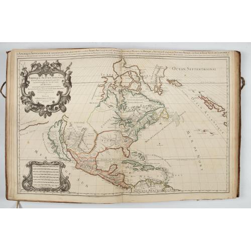
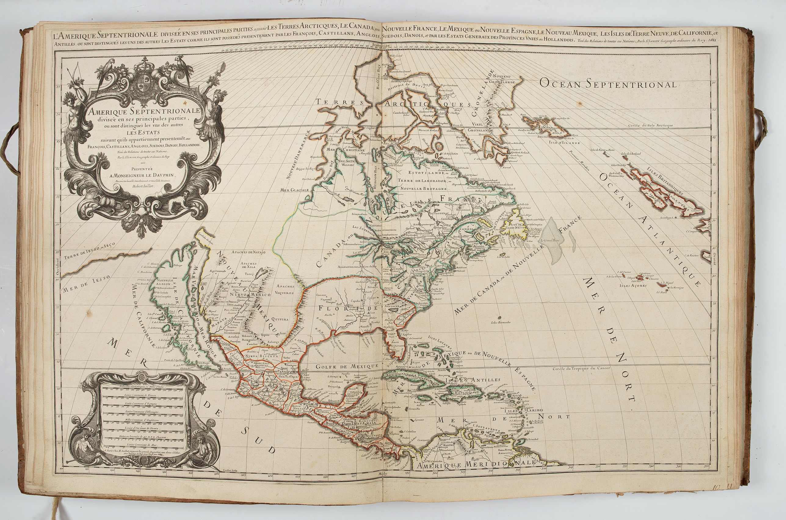
1681 and the Amerique septentrionale divisée...,
The atlas includes, for example, the rare 1681 edition of Amerique septentrionale divisée..., this second state is only reported by Burden in his online "Corrigenda and Addenda, Update to the Mapping of North America", 438, State 2. Burden mentions only one other example discovered in 2014. The map has a reworked date of 1681 in the lower left and upper right corners.
State 1 1674 Dated 1674 lower left and upper right
State 2 1681 Dated 1681 lower left and upper right (This example with only one other recorded example)
State 3 1685 Dated 1685 lower left and upper right, no other alterations
State 4 1690 Dated 1690 lower left, the date top right is erased and left blank
State 5 1719 Dated 1719 lower left. Heavily revised.
State 6 1785 Dated 1785 and the presence of a MER OU BAYE DE L’OUESTÂ
By 1681 Jaillot had enough material to publish L'Atlas Nouveau. With the destruction of the Blaeu
family business by fire in 1672, and the general lack of other competition, a ready market for a quality atlas
had grown. Further editions appeared in 1684 and in 1689. The relationship between the Sanson brothers and
Jaillot, rarely smooth, appears to have broken down altogether by 1690. In that year Pierre Mortier began work on a facsimile edition in Amsterdam. It is known that he had permission to do this and it is presumed to have been with Jaillot, rather than the Sansons. The latter's atlas appears to have been available well into the eighteenth century. However, continuing with the earlier title page dated 1689, and we assume from the surviving contracts that he retained ownership of the copperplates. This Jaillot plate continued to be available unaltered for many years until heavily revised in 1719. Jaillot had died in 1712 and the business was largely passed to his son, Bernard-Jean-Hyacinthe, and then to his son, Bernard-Antoine. Further heirs continued the business until it was finally dispersed at auction in 1781.
The maps in this atlas are dated between 1674 and 1684 except for two slightly shorter maps added later (Les Provinces des Pays Bas Catholiques distinguées... 1707 and Les Montagnes des Alpes ou sont remarqués... 1708).
The "Catalogue des Cartes" includes some handwritten numbering and several maps added in pen in the spaces left blank for that purpose. The tables were composed between 1677 and 1681. Jaillot was already thinking about a future extension of the atlas and a blank space was left for new maps of France and the Netherlands.Â
The present table is as follows: after Le Royaume de France, Picardie was added; after Les Pais Bas catholiques and Les Provinces Unies des Pais-Bas, maps of the different provinces of Flanders, the Netherlands, and Luxembourg were added and then, at the end of the table, different provinces of Germany, Belgium, as well as a map of Poland, were added.
The Atlas Nouveau was published for the first time in 1681 by A.-H. Jaillot, who wanted to become one of the first publishers of geography with this atlas. However, Jaillot is only the publisher, almost all the maps are due to Guillaume Sanson.
The name atlas appears here for the first time in a French atlas title, but it is the image of "l'Hercule françois" and not that of the Titan that appears on the title page. The atlas includes mainly maps of European countries but also a world map, the continents (North and South America), two maps of the Turkish Empire and a map of the Holy Land.
The Atlas Nouveau will have two further enlarged French editions in 1684 and 1689.Â
The present edition of 1684 is rare, Pastoureau mentions only one incomplete copy. Three other copies could be traced between 1936 and 1981 but they are either badly described or incomplete:
1936. Otto Lange catalog N°59. Americana books, maps, views. 80 maps and 19 tables. The copy is described as rare first edition;
1939. Sotheby's catalog. Rare and Valuable collection of voyages & travels, early atlases... 65 double maps. The copy is described as rare first edition;
1981. Sotheby's London catalog. 80 maps and 19 tables. Maps dated between 1674 and 1685. The atlas is described as a single volume (of two).
The maps
[1] Mappe-monde geo-hydrographique... 1681. (Pastoureau, 1684)
[2] L'Europe divisée suivant l'estendue de ses principaux estats... 1674. (Pastoureau, 1684)
[3] L'Asie divisée en ses principales regions... 1674.
[4] L'Afrique divisée suivant l'estendue de ses principales parties... 1674 Les tables sont composées entre 1677 et 1681. Jaillot songe à une extension prochaine de l'atlas et un espace blanc y est laissé pour inscrire de nouvelles cartes de France et des Pays-Bas.
[5] Amerique septentrionale divisée en ses principales parties... 1681 ; [Burden, 438. State 2 1681. Dated 1681 lower left and upper right}. Rare.
[6] Amerique meridionale divisée en ses principales parties... 1674.
[7] Les Isles Britanniques qui contiennent les royaumes d'Angleterre Escosse, et Irlande... 1678.
[8] La Scandinavie et les Environs… 1675
[9] Le royaume de Danemark... 1674.
[10] La Russie blanche ou Moscovie... 1674.
Royaume de France absente (missing)
[11] Le gouvernement general de Picardie oĂą sont le pays reconquis, le Boulenois... 1681.
La Champagne absente (missing)
[12] La Franche Comté divisée en trois grands balliages... 1681.
[13] La Lorraine... 1677.
[14] L'Alsace divisée en ses principales parties... 1675.
[15] Les Monts Pyrenées où sont remarqués les passages de France en Espagne... 1681.
Allemagne absente (missing)
[16] Les Provinces des Pays Bas Catholiques distinguées suivant qu'elles sont presentement partagées entre le roy de France le Roy d'Espagne et les Estats generaux des Provinces Unies... 1707. (Slightly smaller. Later added).
[17] Les Dix-sept provinces des Pays Bas distinguées suivant qu'elles sont possédées à present par les roys de France et d'Espagne et les estats generaux des Provinces-Unies... 1680.
[18] Le Brabant Espagnol qui comprend les quartiers de Brusselles... 1684.
(19] Le Brabant Hollandois qui comprend le quartier de Bos-le-Duc... 1674.
[20] Le Limbourg... 1674.
[21] Le duché de Luxembourg divisé en françois et espagnol... 1674.
[22] Gueldre espagnole ou quartier de Ruremonde... 1681. (Pastoureau, 1674).
[23] La Flandre françoise... 1674.
[24] Le Comté d'Artois suivant qu'il est presentement divisé en françois et espagnol... 1674.
[25] Flandre espagnole et Flandre hollandoise... 1674.
Haynaut absente (missing)
[26] Provinces Unies des Pays Bas avec leurs acquisitions dans la Flandre, le Brabant... 1680.
Comté de Namur absente (missing)
[27] Partie Septentrionale/Méridionale du Comté de Hollande… 1674.
[28] Comté de Zeelande… 1681.
[29] La Veluwe, la Betuwe et le comité de Zutphen dans le duché de Gueldre... 1681.
[30] La seigneurie d'Utrecht... 1681.
[31] La seigneurie d'Over-Yssel subdivisée en trois parties... 1681. (Pastoureau 1674)
[32] La seigneurie de Groningue subdivisée en toutes ses juridictions... 1681
[33] La seigneurie d'Ouest-Frise ou Frise occidentale divisée en ses trois parties... 1681.
[34] Oost-Frise ou comté d’Embden… 1681.
Cours …du Rhein absente (missing)
[35] Le cercle de Souabe subdivisé… 1681.
[36] Le cercle électoral du Rhein subdivisé… 1675.
[37] Archevesché et eslectorat de Cologne avec ses enclaves… 1674.
[38] Partie occidentale du temporel de l'archevesche... de Treves... 1674.
[39] Partie orientale du temporel de l'archevesche...de Treves... 1674.
[40] Partie occidentale du temporel de l'archevesché... de Mayence... 1681 (Pastoureau 1674).
[41] Partie orientale de temporel de l'archevesche... de Mayence... 1681 (Pastoureau 1674).
[42] Partie orientale du Palatinat et eslectorat du Rhein... 1681.
[43] Partie occidentale du Palatinat et eslectoral du Rhein... 1681.
[44] La Basse partie du cercle du Haut Rhein... 1677.Â
[45] Le cercle de Westphalie… 1675
[46] Estat et seigneurie de l'evesché de Lyege... 1681.
[47) Haute partie de l'evesché de Munster... 1681.
[48] Basse partie de l'evesché de Munster... 1681.
[49] Le duché de Cleves, la seigneurie de Ravenstein... 1681.
[50] Le duchĂ© de Juliers, l'abbaye de St Cornelis Munster... 1681.Â
[51] Le duché de Berg, le comté de Homberg...1681. (Pastoureau 1674).
[52] Le comté de La Marck, les seigneuries... de Werden, d'Essen... 1674. (1681)
[53] Le duché de Westphalie... Possedé par l'eslecteur de Cologne... 1674.
[54] Le cercle de Franconie subdivisé en tous les estats qui le composent... 1674. (Pastoureau 1675).
[55] Le cercle de Baviere subdivisé en tous les estats qui le composent... 1675.
[56] Partie du cercle d'Austriche au sont les duchés de Stirie, de Carinthie... 1681. (Pastoureau 1677).
[57] Partie du cercle d'Austriche sçavoir l'Archiduché d'Austriche... 681. (Pastoureau 1677).
[58] Les estats de la couronne de Boheme... 1680.
[59] Le cercle de la Haute Saxe ou sont compris le duché et l'eslectorat de Saxe... 1676.
[60] Le Marquisat et eslectorat de Brandebourg... 1676.
[61] Le duché de Pomeranie divisé en ses principales parties... 1684.
[62] Les Montagnes des Alpes ou sont remarqués les passages de France en Italie, le duché de Milan et les estats du duc de Savoye... 1708. (Slightly smaller. Later added).
[63] Le cercle de la Basse Saxe subdivisé en tous les estats et principautés qui le composent... 1676.
[64] Estats de Pologne subdivisés suivant l'estendue des palatinats... 1681.
[65] L'Espagne divisée en tout ses royaumes et principautés... 1672.
[66] Principauté de Catalogne... 1680.
[67] L'Italie distinguée suivant l'estendue de tous les estats... qui la partagent presentement... 1672.
[68] Le royaume de Naples divisé en douze provinces... 1681.
[69] La Sicile divisée en ses trois provinces... 1681.
[70] Le royaume de Hongrie et les estats qui en ont été sujets et qui sont presentement la partie septentrionale de la Turquie en Europe… 1673.

According to the dates in the atlas it is safe to suggest that this is the very rare second edition of the Atlas Nouveau of 1684.
The edition of 1684 is rare; The contents differ from the then-only recorded copy described by Pastoureau, which she was unable to consult and which is itself incomplete (Chalons-sur-Marne, Bibl. mun. Gt 9385,)
Three other copies could be traced between 1936 and 1981, but they are either badly described or incomplete:
1936. Otto Lange catalog N°59. Americana books, maps, views. 80 maps and 19 tables. The copy is described as rare first edition;
1939. Sotheby's catalog. Rare and Valuable collection of voyages & travels, early atlases... 65 double maps. The copy is described as rare first edition;
1981. Sotheby's London catalog. 80 maps and 19 tables. Maps dated between 1674 and 1685. The atlas is described as a single volume (of two).
The atlas includes, for example, the rare 1681 edition of Amerique septentrionale divisĂ©e..., this second state is only reported by Burden in his online "Corrigenda and Addenda, Update to the Mapping of North America", 438, State 2.Â
State 1 1674 Dated 1674 lower left and upper right
State 2 1681 Dated 1681 lower left and upper right (This example with only one other recorded example)
State 3 1685 Dated 1685 lower left and upper right, no other alterations
State 4 1690 Dated 1690 lower left, the date top right is erased and left blank
State 5 1719 Dated 1719 lower left. Heavily revised.
State 6 1785 Dated 1785 and the presence of a MER OU BAYE DE L’OUESTÂ
The "Catalogue des Cartes" includes some handwritten numbering and several maps added in pen in the spaces left blank for that purpose. The tables were composed between 1677 and 1681. Jaillot was already thinking about a future extension of the atlas and a blank space was left for new maps of France and the Netherlands.Â
The present table is as follows: after Le Royaume de France, Picardie was added; after Les Pais Bas catholiques and Les Provinces Unies des Pais-Bas, maps of the different provinces of Flanders, the Netherlands, and Luxembourg were added and then, at the end of the table, different provinces of Germany, Belgium, as well as a map of Poland, were added.
The Atlas Nouveau was published for the first time in 1681 by A.-H. Jaillot, who wanted to become one of the first publishers of geography with this atlas. However, Jaillot is only the publisher, almost all the maps are due to Guillaume Sanson.
The name atlas appears here for the first time in a French atlas title, but it is the image of "l'Hercule françois" and not that of the Titan that appears on the title page. The atlas includes mainly maps of European countries but also a world map, the continents (North and South America), two maps of the Turkish Empire and a map of the Holy Land.
The Atlas Nouveau will have two further enlarged French editions in 1684 and 1689.Â
The present edition of 1684 is rare, Pastoureau mentions only one incomplete copy. Three other copies could be traced between 1936 and 1981 but they are either badly described or incomplete:
1936. Otto Lange catalog N°59. Americana books, maps, views. 80 maps and 19 tables. The copy is described as rare first edition;
1939. Sotheby's catalog. Rare and Valuable collection of voyages & travels, early atlases... 65 double maps. The copy is described as rare first edition;
1981. Sotheby's London catalog. 80 maps and 19 tables. Maps dated between 1674 and 1685. The atlas is described as a single volume (of two).
The maps
[1] Mappe-monde geo-hydrographique... 1681. (Pastoureau, 1684)
[2] L'Europe divisée suivant l'estendue de ses principaux estats... 1674. (Pastoureau, 1684)
[3] L'Asie divisée en ses principales regions... 1674.
[4] L'Afrique divisée suivant l'estendue de ses principales parties... 1674 Les tables sont composées entre 1677 et 1681. Jaillot songe à une extension prochaine de l'atlas et un espace blanc y est laissé pour inscrire de nouvelles cartes de France et des Pays-Bas.
[5] Amerique septentrionale divisée en ses principales parties... 1681 ; [Burden, 438. State 2 1681. Dated 1681 lower left and upper right}. Rare.
[6] Amerique meridionale divisée en ses principales parties... 1674.
[7] Les Isles Britanniques qui contiennent les royaumes d'Angleterre Escosse, et Irlande... 1678.
[8] La Scandinavie et les Environs… 1675
[9] Le royaume de Danemark... 1674.
[10] La Russie blanche ou Moscovie... 1674.
Royaume de France absente (missing)
[11] Le gouvernement general de Picardie oĂą sont le pays reconquis, le Boulenois... 1681.
La Champagne absente (missing)
[12] La Franche Comté divisée en trois grands balliages... 1681.
[13] La Lorraine... 1677.
[14] L'Alsace divisée en ses principales parties... 1675.
[15] Les Monts Pyrenées où sont remarqués les passages de France en Espagne... 1681.
Allemagne absente (missing)
[16] Les Provinces des Pays Bas Catholiques distinguées suivant qu'elles sont presentement partagées entre le roy de France le Roy d'Espagne et les Estats generaux des Provinces Unies... 1707. (Slightly smaller. Later added).
[17] Les Dix-sept provinces des Pays Bas distinguées suivant qu'elles sont possédées à present par les roys de France et d'Espagne et les estats generaux des Provinces-Unies... 1680.
[18] Le Brabant Espagnol qui comprend les quartiers de Brusselles... 1684.
(19] Le Brabant Hollandois qui comprend le quartier de Bos-le-Duc... 1674.
[20] Le Limbourg... 1674.
[21] Le duché de Luxembourg divisé en françois et espagnol... 1674.
[22] Gueldre espagnole ou quartier de Ruremonde... 1681. (Pastoureau, 1674).
[23] La Flandre françoise... 1674.
[24] Le Comté d'Artois suivant qu'il est presentement divisé en françois et espagnol... 1674.
[25] Flandre espagnole et Flandre hollandoise... 1674.
Haynaut absente (missing)
[26] Provinces Unies des Pays Bas avec leurs acquisitions dans la Flandre, le Brabant... 1680.
Comté de Namur absente (missing)
[27] Partie Septentrionale/Méridionale du Comté de Hollande… 1674.
[28] Comté de Zeelande… 1681.
[29] La Veluwe, la Betuwe et le comité de Zutphen dans le duché de Gueldre... 1681.
[30] La seigneurie d'Utrecht... 1681.
[31] La seigneurie d'Over-Yssel subdivisée en trois parties... 1681. (Pastoureau 1674)
[32] La seigneurie de Groningue subdivisée en toutes ses juridictions... 1681
[33] La seigneurie d'Ouest-Frise ou Frise occidentale divisée en ses trois parties... 1681.
[34] Oost-Frise ou comté d’Embden… 1681.
Cours …du Rhein absente (missing)
[35] Le cercle de Souabe subdivisé… 1681.
[36] Le cercle électoral du Rhein subdivisé… 1675.
[37] Archevesché et eslectorat de Cologne avec ses enclaves… 1674.
[38] Partie occidentale du temporel de l'archevesche... de Treves... 1674.
[39] Partie orientale du temporel de l'archevesche...de Treves... 1674.
[40] Partie occidentale du temporel de l'archevesché... de Mayence... 1681 (Pastoureau 1674).
[41] Partie orientale de temporel de l'archevesche... de Mayence... 1681 (Pastoureau 1674).
[42] Partie orientale du Palatinat et eslectorat du Rhein... 1681.
[43] Partie occidentale du Palatinat et eslectoral du Rhein... 1681.
[44] La Basse partie du cercle du Haut Rhein... 1677.Â
[45] Le cercle de Westphalie… 1675
[46] Estat et seigneurie de l'evesché de Lyege... 1681.
[47) Haute partie de l'evesché de Munster... 1681.
[48] Basse partie de l'evesché de Munster... 1681.
[49] Le duché de Cleves, la seigneurie de Ravenstein... 1681.
[50] Le duchĂ© de Juliers, l'abbaye de St Cornelis Munster... 1681.Â
[51] Le duché de Berg, le comté de Homberg...1681. (Pastoureau 1674).
[52] Le comté de La Marck, les seigneuries... de Werden, d'Essen... 1674. (1681)
[53] Le duché de Westphalie... Possedé par l'eslecteur de Cologne... 1674.
[54] Le cercle de Franconie subdivisé en tous les estats qui le composent... 1674. (Pastoureau 1675).
[55] Le cercle de Baviere subdivisé en tous les estats qui le composent... 1675.
[56] Partie du cercle d'Austriche au sont les duchés de Stirie, de Carinthie... 1681. (Pastoureau 1677).
[57] Partie du cercle d'Austriche sçavoir l'Archiduché d'Austriche... 681. (Pastoureau 1677).
[58] Les estats de la couronne de Boheme... 1680.
[59] Le cercle de la Haute Saxe ou sont compris le duché et l'eslectorat de Saxe... 1676.
[60] Le Marquisat et eslectorat de Brandebourg... 1676.
[61] Le duché de Pomeranie divisé en ses principales parties... 1684.
[62] Les Montagnes des Alpes ou sont remarqués les passages de France en Italie, le duché de Milan et les estats du duc de Savoye... 1708. (Slightly smaller. Later added).
[63] Le cercle de la Basse Saxe subdivisé en tous les estats et principautés qui le composent... 1676.
[64] Estats de Pologne subdivisés suivant l'estendue des palatinats... 1681.
[65] L'Espagne divisée en tout ses royaumes et principautés... 1672.
[66] Principauté de Catalogne... 1680.
[67] L'Italie distinguée suivant l'estendue de tous les estats... qui la partagent presentement... 1672.
[68] Le royaume de Naples divisé en douze provinces... 1681.
[69] La Sicile divisée en ses trois provinces... 1681.
[70] Le royaume de Hongrie et les estats qui en ont été sujets et qui sont presentement la partie septentrionale de la Turquie en Europe… 1673.
FAQ - Guarantee - Shipping
Buying in the BuyNow Gallery
This item is available for immediate purchase when a "Add to Cart" or "Inquire Now" button is shown.
Payments are accepted in Euros or US Dollars. We accept most major credit cards, PayPal and bank transfer.
Authenticity Guarantee
 We provide professional descriptions, condition report and HiBCoR rating (based on 45 years experience in the map business)
We fully guarantee the authenticity of items we sell. We provide a certificate of authenticity for each purchased item.
Condition / Coloring
We indicate the condition of each item and use our unnique HiBCoR grading system in which four key items determine a map's value: Historical Importance, Beauty, Condition/Coloring and Rarity.
We offer many maps in their original black and white condition. We do not systematically color-up maps to make them more sellable to the general public or buyer.
Copper engraved or wood block maps are always hand colored. Maps were initially colored for aesthetic reasons and to improve readability. Nowadays, it is becoming a challenge to find maps in their original colors and are therefor more valuable.
We use the following color keys in our catalog:
Original colors; mean that the colors have been applied around the time the map was issued.
Colored; If the colors are applied recently or at the end of the 20th century, then "colored", or "attractive colors" will be used.
Original o/l colors; means the map has only the borders colored at the time of publication.
Read more about coloring of maps [+]
FAQ
Please have a look for more information about buying in the BuyNow gallery.
Many answers are likely to find in the general help section.
Virtual Collection
![]()
With Virtual Collection you can collect all your favorite items in one place. It is free, and anyone can create his or her Virtual map collection.
Unless you are logged in, the item is only saved for this session. You have to be registed and logged-in if you want to save this item permanently to your Virtual Collection.
Read More [+]
If you want to save the items permanently, please sign in
or create account first. ![]()
Registering Here, it is and you do not need a credit card.
Add this item to
Virtual Collection
or click the following link to see my Virtual Collection.
Invoice
The invoice and certificates of authenticity are available in the client center >Invoices
| Digital Image Download | |
|
Paulus Swaen maintains an archive of most of our high-resolution rare maps, prints, posters and medieval manuscript scans. We make them freely available for download and study. Read more about free image download |
Click the image for a free small image download. |
![Rare, antique map of Atlas Nouveau. [With 74 single or double-page maps]](/uploads/48598F.jpg)
![Rare, antique map of Atlas Nouveau. [With 74 single or double-page maps]](/uploads/48598X.jpg)
![Rare, antique map of Atlas Nouveau. [With 74 single or double-page maps]](/uploads/48598B.jpg)
![Rare, antique map of Atlas Nouveau. [With 74 single or double-page maps]](/uploads/48598A.jpg)
![Rare, antique map of Atlas Nouveau. [With 74 single or double-page maps]](/uploads/48598C.jpg)
![Rare, antique map of Atlas Nouveau. [With 74 single or double-page maps]](/uploads/48598E.jpg)
![Rare, antique map of Atlas Nouveau. [With 74 single or double-page maps]](/uploads/48598D.jpg)
![Rare, antique map of Atlas Nouveau. [With 74 single or double-page maps]](/uploads/48598.jpg)
![Rare, antique map of Atlas Nouveau. [With 74 single or double-page maps]](/uploads/48598I.jpg)
![Rare, antique map of Atlas Nouveau. [With 74 single or double-page maps]](/uploads/48598H.jpg)
![Rare, antique map of Atlas Nouveau. [With 74 single or double-page maps]](/uploads/48598J.jpg)
![Rare, antique map of Atlas Nouveau. [With 74 single or double-page maps]](/uploads/48598N.jpg)
![Rare, antique map of Atlas Nouveau. [With 74 single or double-page maps]](/uploads/48598M.jpg)
![Rare, antique map of Atlas Nouveau. [With 74 single or double-page maps]](/uploads/48598P.jpg)
![Rare, antique map of Atlas Nouveau. [With 74 single or double-page maps]](/uploads/48598O.jpg)
![Rare, antique map of Atlas Nouveau. [With 74 single or double-page maps]](/uploads/48598R.jpg)
![Rare, antique map of Atlas Nouveau. [With 74 single or double-page maps]](/uploads/48598S.jpg)
![Rare, antique map of Atlas Nouveau. [With 74 single or double-page maps]](/uploads/48598L.jpg)
![Rare, antique map of Atlas Nouveau. [With 74 single or double-page maps]](/uploads/48598K.jpg)
![Rare, antique map of Atlas Nouveau. [With 74 single or double-page maps]](/uploads/48598T.jpg)
![Rare, antique map of Atlas Nouveau. [With 74 single or double-page maps]](/uploads/48598V.jpg)
![Rare, antique map of Atlas Nouveau. [With 74 single or double-page maps]](/uploads/48598U.jpg)
![Rare, antique map of Atlas Nouveau. [With 74 single or double-page maps]](/uploads/48598Q.jpg)
In accordance with the EU Consumer Rights Directive and habitually reside in the European Union you have the right to cancel the contract for the purchase of a lot, without giving any reason.
The cancellation period will expire 14 calendar days from the day after the date on which you or a third party (other than the carrier and indicated by you) acquires, physical possession of the lot. To exercise the right to cancel you must inform Paulus Swaen Inc, of your decision to cancel this contract by a clear statement (e.g. a letter sent by post, or e-mail (amsterdam@swaen.com).
To meet the cancellation deadline, it is sufficient for you to send your communication concerning your exercise of the right to cancel before the cancellation period has expired.
