Subscribe to be notified if similar examples become available.
A New Map of North America, with the West India Islands. Divided according to the Preliminary Articles of Peace, Signed at Versailles, 20, Jan. 1783. wherein are particularly Distinguished the United States, and the Several Provinces, Governments & ca whi |
||||||||||||||||||||
|
||||||||||||||||||||
|
|
||||||||||||||||||||
|
|
Virtual Collection - Save and collect this or any of your favorite items in one place.
If you want to save the items permanently, please sign in or create account first. |
|||||||||||||||||||
Description
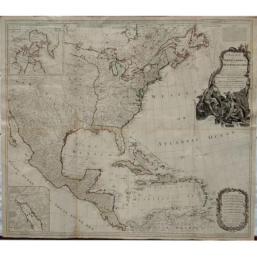
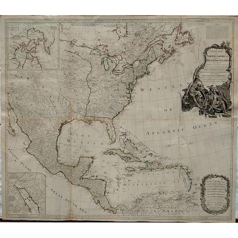
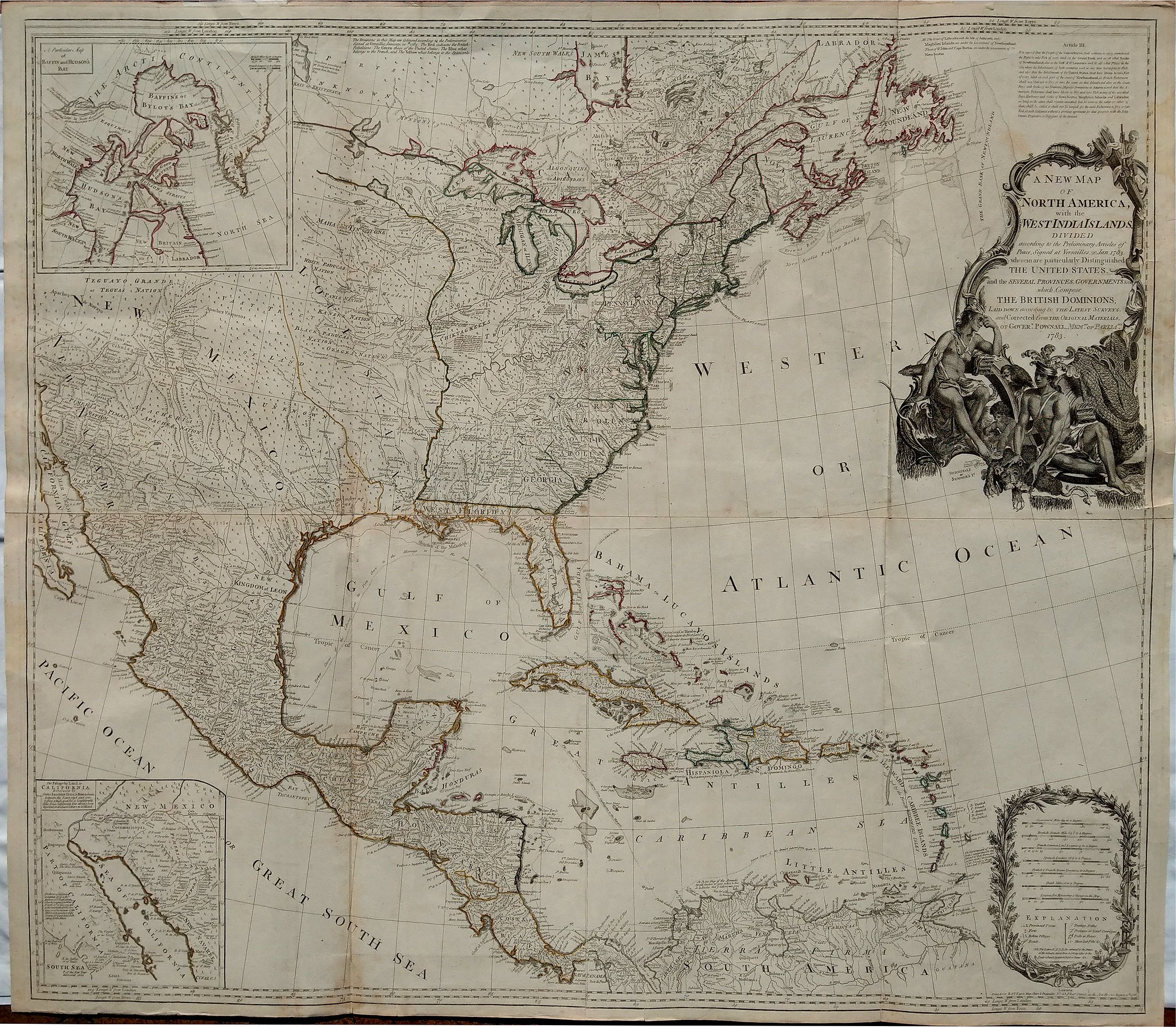
A stately and important wall map of North America that shows the new United States following the signing of the 1783 Treaty of Paris, which ended the American Revolutionary War.
This large and influential map extends to include all of then-known North America and the West Indies. It had a long and varied publishing history. Originally issued separately by Emanuel Bowen & John Gibson in 1755, it was periodically updated following the conclusion of the Seven Years’ War (the “French and Indian War”), in 1763, and the American Revolutionary War, in 1783. Between 1755 and 1798, the map went through numerous revisions and editions to document the expanding cartographic knowledge and changing political landscape of North America. Beginning in 1775, it was bound into some of the most influential American atlases of the era, including those issued by Jefferys, Faden, and Sayer & Bennett. Beginning in the late 1770s, the map was updated to include revisions compiled by Governor George Pownall, including information from Evans' and other indigenous sources.
This edition is dated “1786”, providing an extremely detailed view of the continent at the conclusion of the American Revolution. With outline hand color, the United States is shown with its 1783 peace treaty boundaries, and the British, French, and Spanish possessions are noted. In addition, some Caribbean islands are indicated as being Dutch, Danish or Swedish.
Among other details, the map identifies hundreds of settlements, forts, Indian villages, roads, trading paths, shipping routes, and mines and salt pits. It also displays numerous annotations referring to native tribes and historical events, including “Guanahani, Cat Island or St. Salvador: the First Land of all America discover’d by Columbus 1492”.
There are two interesting inset maps. The one to the upper left illustrates the ongoing search for a Northwest Passage, showing Baffin’s Bay and Hudson’s Bay with the fictional Lake de Fonte nearby. The one to the lower left shows “The Passage by Land to California, Discovered by Father Eusebius Kino[,] a Jesuit, between the Years 1698 and 1701, …” that proved that California was not an island.
To the upper right of the map is a four-line note about coastal responsibilities of the governments of Newfoundland and Nova Scotia, plus a citation of Article III of the peace treaty, which details fishing rights. To the lower right is a large cartouche for scale of miles and map legend.
The large figurative title cartouche is highly decorative and features three Native Americans with their accoutrements, as well as three indigenous animals. It is a visually astounding piece of engraving and has been strengthened from previous issues, featuring fine crosshatching.
A visually striking copy of a spectacular and fascinating map.
Reference: TOOLEY, R.V., The Mapping of America, p. 81ff.
FAQ - Guarantee - Shipping
Buying in the BuyNow Gallery
This item is available for immediate purchase when a "Add to Cart" or "Inquire Now" button is shown.
Items are sold in the EU margin scheme
Payments are accepted in Euros or US Dollars.
Authenticity Guarantee
 We provide professional descriptions, condition report (based on 45 years experience in the map business)
Paulus Swaen warrants the authenticity of our items and a certificate of authenticity is provided for each acquired lot.
Condition and Coloring
We indicate the condition of each item and use our unnique HiBCoR grading system in which four key items determine a map's value: Historical Importance, Beauty, Condition/Coloring and Rarity.
Color Key
We offer many maps in their original black and white condition. We do not systematically color-up maps to make them more sellable to the general public or buyer.
Copper engraved or wood block maps are always hand colored. Maps were initially colored for aesthetic reasons and to improve readability. Nowadays, it is becoming a challenge to find maps in their original colors and are therefor more valuable.
We use the following color keys in our catalog:
Original colors; mean that the colors have been applied around the time the map was issued.
Original o/l colors; means the map has only the borders colored at the time of publication.
Colored; If the colors are applied recently or at the end of the 20th century.
Read more about coloring of maps [+]
Shipping fee
A flat shipping fee of $ 30 is added to each shipment by DHL within Europe and North America. This covers : International Priority shipping, Packing and Insurance (up to the invoice amount).
Shipments to Asia are $ 40 and rest of the world $50
We charge only one shipping fee when you have been successful on multiple items or when you want to combine gallery and auction purchases.
Read more about invoicing and shipping
FAQ
Please have a look for more information about buying in the BuyNow gallery
Many answers are likely to find in the general help section.
Virtual Collection
![]()
With Virtual Collection you can collect all your favorite items in one place. It is free, and anyone can create his or her Virtual map collection.
Unless you are logged in, the item is only saved for this session. You have to be registed and logged-in if you want to save this item permanently to your Virtual Collection.
Read More[+]
Register here, it is free and you do not need a credit card.
Add this item to
Virtual Collection
or click the following link to see my Virtual Collection.
| Digital Image Download | |
|
Paulus Swaen maintains an archive of most of our high-resolution rare maps, prints, posters and medieval manuscript scans. We make them freely available for download and study. Read more about free image download |
Click the image for a free small image download. |
In accordance with the EU Consumer Rights Directive and habitually reside in the European Union you have the right to cancel the contract for the purchase of a lot, without giving any reason.
The cancellation period will expire 14 calendar days from the day after the date on which you or a third party (other than the carrier and indicated by you) acquires, physical possession of the lot. To exercise the right to cancel you must inform Paulus Swaen Inc, of your decision to cancel this contract by a clear statement (e.g. a letter sent by post, or e-mail (amsterdam@swaen.com).
To meet the cancellation deadline, it is sufficient for you to send your communication concerning your exercise of the right to cancel before the cancellation period has expired.

