Subscribe to be notified if similar examples become available.
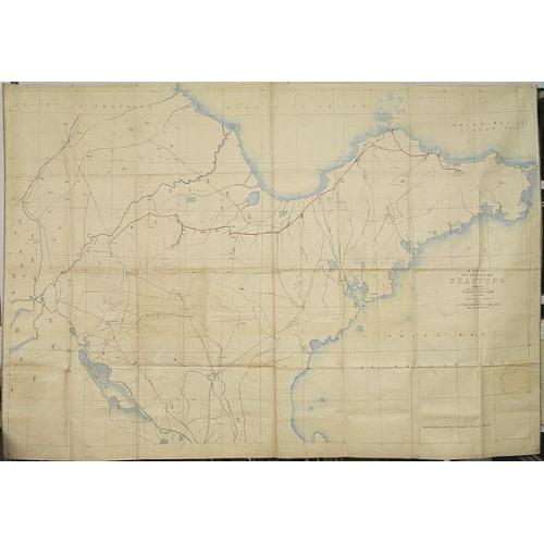
A map of the Province of Shantung compiled under the direction of Thomas T.Fergusson of Chefoo Stanfords geographical Establisment 1873 with projected raiway to coal mines and Tsi-Nan-Foo. |
||||||||||||||||||||
|
||||||||||||||||||||
|
|
||||||||||||||||||||
|
|
Virtual Collection - Save and collect this or any of your favorite items in one place.
If you want to save the items permanently, please sign in or create account first. |
|||||||||||||||||||
Description
A manuscript map of the province Shantung (or the present-day standard pinyin, Shandong) compiled under the direction of Thomas T.Fergusson of Chefoo Stanfords geographical Establisment 1873 with projected raiway from Chefoo (now usually called Yantai) to Tsinan (now transliterated as Ji'nan).
The map carries a date 1873, which was quite early in terms of railroad building in China and at that time there was very little interest on the part of Qing dynasty officials in railway construction. Ferguson would have needed both Qing approval and foreign financing to get such a project underway. In those days Chinese officials and the Chinese public were more likely to oppose railways.
The map has the towns mentioned in Chinese, some main town are also in English. Interestingly the map notes the areas where coal, iron, jade stone, silk, silver, etc. are found.
In the upper left the Yellow River, also called "the cradle of Chinese civilization", as its basin is the birthplace of the northern Chinese civilizations and was the most prosperous region in early Chinese history.
The red line drawn from Chefoo to Ji'nan through Wei-hsien (now Weifang) represents the track of the proposed railway.
The map shows the line starting somewhat east of Yantai and Chefoo, both unmarked, but located on the bay near 121.30E 30N. In the 1870s American Protestant missionaries had a considerable base at Chefoo and Chefoo was a well established port on the Bohai Gulf with regular shipping service to Tientsin (Tianjin), Manchuria and Shanghai. More important in administrative terms was the city of Yentai (Yantai) a few miles southwest of Chefoo. So foreigners preferred to refer to the whole area as Chefoo (now transliterated at Zhifu) .
Place names of the principal towns are written by a native Chinese in standard characters. Some notations of distances are given in Chinese _li_ (late 19th c sources say a li = 1890 ft or just over one-third of a mile; presentday Chinese dictionaries say a li = .5 kilometers. Either measure would give an approximation). Distances in li are not given for all portions of the route. Someone has added notations on the map indicating the location of mineral deposits and on the eastern Shandong peninsula some indication on handicraft production. These appear only in English.
There are two branch off the mainline. The easternmost terminates at Penglai, another port on northern part of the Shandong peninsula. The Chefoo port and Yantai city were more important places in the 1870s as they continue to be today. The other extends southward to Boshan where the word "Coal" appears.
Boshan did develop into a thriving coal mining district and its mines provided coal to the German built Tsingtao-Tsinan railway (Qingdao-Ji'nan) railway built in the years 1902-1906.
The route mapped by Fergusson follows closely the old established roads that were used to move goods and people to Penglai and Chefoo. Both ports, along with Tientsin, became jumping off points for the waves of seasonal and permanent migration of North China peasants into Manchuria that received official Qing sanction in the 1860s. So Furgeson's proposal reflects the actual needs of his day. Prior to the German's claiming Tsingtao in 1898 it was of little economic importance, although it was a good harbor.
Thanks to : David D. Buck for giving this information. ¤
A manuscript map of the province Shantung (or the present-day standard pinyin, Shandong) compiled under the direction of Thomas T.Fergusson of Chefoo Stanfords geographical Establisment 1873 with projected raiway from Chefoo (now usually called Yantai) to Tsinan (now transliterated as Ji'nan).
The map carries a date 1873, which was quite early in terms of railroad building in China and at that time there was very little interest on the part of Qing dynasty officials in railway construction. Ferguson would have needed both Qing approval and foreign financing to get such a project underway. In those days Chinese officials and the Chinese public were more likely to oppose railways.
The map has the towns mentioned in Chinese, some main town are also in English. Interestingly the map notes the areas where coal, iron, jade stone, silk, silver, etc. are found.
In the upper left the Yellow River, also called "the cradle of Chinese civilization", as its basin is the birthplace of the northern Chinese civilizations and was the most prosperous region in early Chinese history.
The red line drawn from Chefoo to Ji'nan through Wei-hsien (now Weifang) represents the track of the proposed railway.
The map shows the line starting somewhat east of Yantai and Chefoo, both unmarked, but located on the bay near 121.30E 30N. In the 1870s American Protestant missionaries had a considerable base at Chefoo and Chefoo was a well established port on the Bohai Gulf with regular shipping service to Tientsin (Tianjin), Manchuria and Shanghai. More important in administrative terms was the city of Yentai (Yantai) a few miles southwest of Chefoo. So foreigners preferred to refer to the whole area as Chefoo (now transliterated at Zhifu) .
Place names of the principal towns are written by a native Chinese in standard characters. Some notations of distances are given in Chinese _li_ (late 19th c sources say a li = 1890 ft or just over one-third of a mile; presentday Chinese dictionaries say a li = .5 kilometers. Either measure would give an approximation). Distances in li are not given for all portions of the route. Someone has added notations on the map indicating the location of mineral deposits and on the eastern Shandong peninsula some indication on handicraft production. These appear only in English.
There are two branch off the mainline. The easternmost terminates at Penglai, another port on northern part of the Shandong peninsula. The Chefoo port and Yantai city were more important places in the 1870s as they continue to be today. The other extends southward to Boshan where the word "Coal" appears.
Boshan did develop into a thriving coal mining district and its mines provided coal to the German built Tsingtao-Tsinan railway (Qingdao-Ji'nan) railway built in the years 1902-1906.
The route mapped by Fergusson follows closely the old established roads that were used to move goods and people to Penglai and Chefoo. Both ports, along with Tientsin, became jumping off points for the waves of seasonal and permanent migration of North China peasants into Manchuria that received official Qing sanction in the 1860s. So Furgeson's proposal reflects the actual needs of his day. Prior to the German's claiming Tsingtao in 1898 it was of little economic importance, although it was a good harbor.
FAQ - Guarantee - Shipping
Buying in the BuyNow Gallery
This item is available for immediate purchase when a "Add to Cart" or "Inquire Now" button is shown.
Items are sold in the EU margin scheme
Payments are accepted in Euros or US Dollars.
Authenticity Guarantee
 We provide professional descriptions, condition report (based on 45 years experience in the map business)
Paulus Swaen warrants the authenticity of our items and a certificate of authenticity is provided for each acquired lot.
Condition and Coloring
We indicate the condition of each item and use our unnique HiBCoR grading system in which four key items determine a map's value: Historical Importance, Beauty, Condition/Coloring and Rarity.
Color Key
We offer many maps in their original black and white condition. We do not systematically color-up maps to make them more sellable to the general public or buyer.
Copper engraved or wood block maps are always hand colored. Maps were initially colored for aesthetic reasons and to improve readability. Nowadays, it is becoming a challenge to find maps in their original colors and are therefor more valuable.
We use the following color keys in our catalog:
Original colors; mean that the colors have been applied around the time the map was issued.
Original o/l colors; means the map has only the borders colored at the time of publication.
Colored; If the colors are applied recently or at the end of the 20th century.
Read more about coloring of maps [+]
Shipping fee
A flat shipping fee of $ 30 is added to each shipment by DHL within Europe and North America. This covers : International Priority shipping, Packing and Insurance (up to the invoice amount).
Shipments to Asia are $ 40 and rest of the world $50
We charge only one shipping fee when you have been successful on multiple items or when you want to combine gallery and auction purchases.
Read more about invoicing and shipping
FAQ
Please have a look for more information about buying in the BuyNow gallery
Many answers are likely to find in the general help section.
Virtual Collection
![]()
With Virtual Collection you can collect all your favorite items in one place. It is free, and anyone can create his or her Virtual map collection.
Unless you are logged in, the item is only saved for this session. You have to be registed and logged-in if you want to save this item permanently to your Virtual Collection.
Read More[+]
Register here, it is free and you do not need a credit card.
Add this item to
Virtual Collection
or click the following link to see my Virtual Collection.
| Digital Image Download | |
|
Paulus Swaen maintains an archive of most of our high-resolution rare maps, prints, posters and medieval manuscript scans. We make them freely available for download and study. Read more about free image download |
Click the image for a free small image download. |
In accordance with the EU Consumer Rights Directive and habitually reside in the European Union you have the right to cancel the contract for the purchase of a lot, without giving any reason.
The cancellation period will expire 14 calendar days from the day after the date on which you or a third party (other than the carrier and indicated by you) acquires, physical possession of the lot. To exercise the right to cancel you must inform Paulus Swaen Inc, of your decision to cancel this contract by a clear statement (e.g. a letter sent by post, or e-mail (amsterdam@swaen.com).
To meet the cancellation deadline, it is sufficient for you to send your communication concerning your exercise of the right to cancel before the cancellation period has expired.
