![Anverpia, nobile in Barbantia oppidum, parrim maritimum . . . [Antwerp]](/uploads/cache/26518-250x250.jpg)
Anverpia, nobile in Barbantia oppidum, parrim maritimum . . . [Antwerp]
The bird's-eye plan provides an excellent view of the citadel, city, docks and fortifications. The city was defended by a line of fortification and a moat constructed und...
Date: Cologne, 1585

The hanging of the head of police Jean Grauwels in Brussels, 11 february 1569.
Print relating to Brussels during the first decades of the eighty year war between Spain and the Low Countries: (plate 18). This plate shows the hanging of the head of po...
Date: Cologne, ca. 1590

Flandria.
Very decorative, egg-shaped map. This is the last and very rare third state with the signature Theodorus Galle. The fortifications along the Scheldt River are added and t...
Date: Antwerp, after 1612
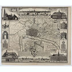
Marchionatus Sacri Romani Imperii.
Plan of the city of Antwerp in Belgium, by Claes Janszoon Visscher and first published by his son. The map is surrounded by 3 city views and 10 building vignettes and inc...
Date: Amsterdam 1624

Marchionatus Sacri Romani Imperii.
A wonderfully decorative map showing in the middle of the image a town plan from Antwerp and in the lower part an inset with a panoramic view of the city and harbour of A...
Date: Amsterdam, 1617- 1624

Kaerte van Bergen op Zoom, Steenbergen ende de nieuwe fortificatien gemaeckt tot bevrÿdinge van 't landt van ter Tolen in tjaar 1628.
Very detailed and scarce map showing Bergen Op Zoom, Steenbergen and its surrounding countryside. North to the left side.
Date: Amsterdam, after 1628

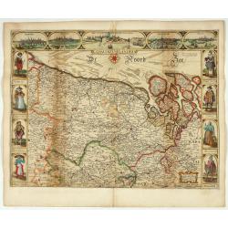
Comitatus Flandria.
First published by the van Langrens c.1595, after his acquisition of the plate, Visscher heavily re-engraved the map, inserting panelled borders on three sides (the lower...
Date: Amsterdam, c. 1630

Belgium sive Inferior Germania post omnes..
Early map of the Low Countries, engraved by Abraham Goos and published for the first time in 1618. In the top border town-views of Amsterdam, Dordrecht, Antwerp, and Brus...
Date: Amsterdam, 1618/1631

Belgii sive Germaniae Inferioris accuratissima tabula.
Very rare and very decorative map with in the right and left borders costumed figures and town plans alternately. In top and bottom border town plans and views.Separate p...
Date: Amsterdam, 1631

Belgium, sive Inferior Germania post omnes…
Third state (only 3 recorded copies) of this scarce map of the 17 Provinces, published by Peter Verbiest in Antwerp. West at top. The maps by Pieter van den Keere in 1607...
Date: Antwerp, 1636
Comitatus Flandria.
Second state of this scarce Carte-a-Figures of Flanders, published by Peter Verbiest in Antwerp decorated with 3 side panels without bottom border (variant of the second ...
Date: Antwerp, 1637

Les Provinces des Pays Bas.
RARE. From his first edition of his only folio atlas, the map is relied upon the map of his uncle, Nicolas Sanson. Engraved by I.Somer.A nice map of Netherlands.
Date: Paris 1687

Le comte de Namur et partie des Duchez de Brabant. . .
Decorative map centered on Namen and including the towns of Liege, Leuven, Charleroi, Dinant, Luxemburg, etc. by François Jollain (ca. 1641 – 18 April 1704).Rare "...
Date: Paris, c. 1692
![Flandra parte occidentale: dedicata all'illustrissimo et eccelententissimo S. Giorgio Cocco, senatore meritissimo. . . [together with] Zelanda e Parte Orientale della Flandra. . . .](/uploads/cache/31286-250x250.jpg)
Flandra parte occidentale: dedicata all'illustrissimo et eccelententissimo S. Giorgio Cocco, senatore meritissimo. . . [together with] Zelanda e Parte Orientale della Flandra. . . .
Wall sized map of two joined sheets of Flanders, the coastline running from Calais to Zeeland in the Netherlands. Including major cities along the coast such as Dunkerque...
Date: Venice, 1696

Novissima Flandriae Comitatus tabula. . .
Rare issue of Theodorus Danckert's attractive map of eastern Belgium provinces, Flanders, with Brugge, Oostende, Gent, Mons, Antwerp, Cambray, etc..Decorative title carto...
Date: Amsterdam, 1700
Carte Des Pays Bas Catholiques Dressée. . .
Rare with the address "Chez l’Auteur sur le Quai de l’Horloge a la Cour. ne de Diamans, 1702. Se trouve à Amsterdam chez L. Renard Libraire près de la Bourse.&...
Date: Paris, 1702
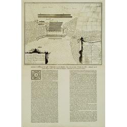
Plan De l'Action.. Auprès de Wynendale le 28 Sept. 1708.
A rare broadside sheet represents a conventional battle plan near the town of Torhout with the Castle Wynendale. The plan depicts the situation of 28 September 1708. Incl...
Date: Bruxelles, c.1708
![Malines. [Mechelen]](/uploads/cache/13125-250x250.jpg)
Malines. [Mechelen]
A very RARE panoramic town view of Mechelen, including a numbered legend in the left lower corner.Published by the brothers Chéreau, active in Paris at rue st.Jacques au...
Date: Paris, c.1720

Teatro della guerra nelle Flandre Austriache e Francesi. . .
Rare folio-sized map of Belgium by Antonio Zatta e Figli, from a never-finished atlas by the ‘Società Calcografia’, a partnership of the two main Venetian publishers...
Date: Venise, 1803
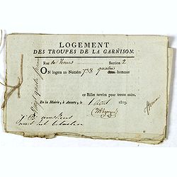
Logement des troupes de la garnison. . .
Seven coupons "Logement des troupes de la garnison ce billet servira pour trente nuits" giving a soldier the right for housing at 738 Rue de Venus in Antwerp in...
Date: Antwerp, 1813

Provincia ecclesiastica di Malines nel Belgio (Tav LXII)
This large-format map of Belgium with its different dioceses. The map is finely engraved and beautifully colored and was prepared by Girolamo Petri, a lawyer who served a...
Date: Rome, 1858

Circoscrizione delle Provincie ecclesiastiche e Diocesi nei regni del Belgio, ed Olanda (Tav LXI)
This large-format map showing Belgium and Holland with its different dioceses. The map is finely engraved and beautifully colored and was prepared by Girolamo Petri, a la...
Date: Rome, 1858
