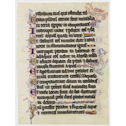
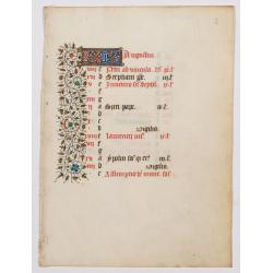
Browse Listings
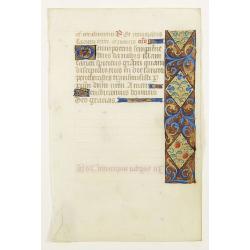
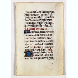
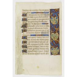
Illuminated leaf from a liturgical Psalter.
Very fine illuminated leaf from a liturgical Psalter in Latin with the reading from the Vulgate Bible. Lines in a slightly irregular Gothic hand, written in black ink, wi...
Date: England, c. 1280
Selling price: ????
Please login to see price!
Sold in 2025
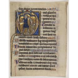
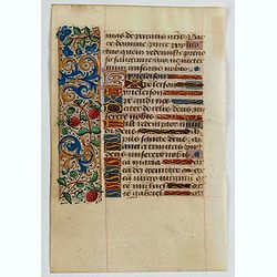
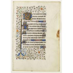
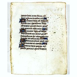
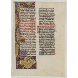
Illuminated leaf from a Psalter.
Very fine 20 lines illuminated leaf from a liturgical Psalter in Latin with the reading from the Vulgate Bible. Lines in a slightly irregular gothic hand, black ink, plum...
Date: Flanders, Rhineland, or possibly England, c. 1280
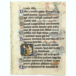
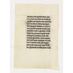
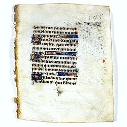
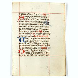
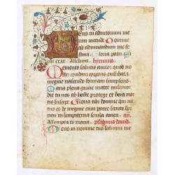
Illuminated leaf from a liturgical Psalter.
Rare illuminated leaf from a liturgical Psalter in Latin with the reading from the Vulgate Bible. Lines in a slightly irregular gothic hand, black ink, plummet ruling. Ve...
Date: England, c. 1280
Selling price: ????
Please login to see price!
Sold in 2024
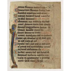
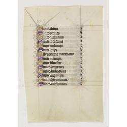
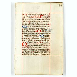
Illuminated leaf from a liturgical Psalter.
A very fine illuminated leaf from a liturgical Psalter in Latin with the reading from the Vulgate Bible. Lines in a slightly irregular Gothic hand, black ink, plummet rul...
Date: Flanders, Rhineland, or possibly England, c. 1280
Selling price: ????
Please login to see price!
Sold in 2025
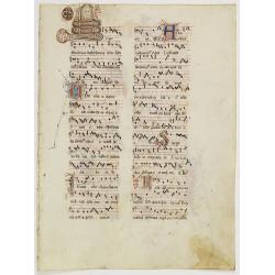
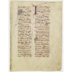
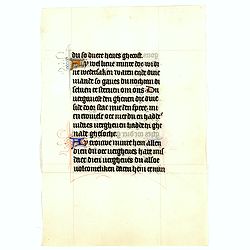
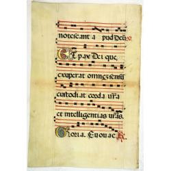
Leaf on vellum from an antiphonary.
A more than 600 years old antiphonary leaf, written in Besançon, in 1370. Musical notation on 4 bars, the staves are in red and the notes in black: numerous pen-flourish...
Date: Besançon, 1370
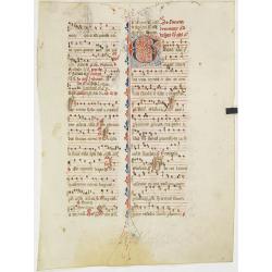
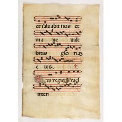
Leaf on vellum from an antiphonary.
A more than 600 years old antiphonary leaf, written in Besançon, in 1370. Musical notation on 4 bars, the staves are in red and the notes in black: numerous pen-flourish...
Date: Besançon, 1370
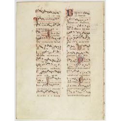
Leaf on vellum from an antiphonary.
A more than 600 years old antiphonary leaf, written in Besançon, in 1370. Musical notation on 4 bars, the staves are in red and the notes in black: numerous pen-flourish...
Date: France, 1370
Leaf on vellum from an antiphonary.
A more than 600 years old antiphonary leaf, written in Besançon, in 1370. Musical notation on 4 bars, the staves are in red and the notes in black: numerous pen-flourish...
Date: France, Besançon, 1370
Leaf on vellum from a Missal.
A very fine Missal leaf, written in Latin. RECTO: A wonderful initial P decorated with pen work in red, purple and blue. The initial is 6x6cm. VERSO: 18 lines written in ...
Date: France, c. 1410
Manuscript leaf on vellum from a Dutch Book of Hours.
VERSO: Two 2-line capitals in burnished gold with extensive penwork in blue and red. Two 1-line capitals in red, blue or burnished gold with extensive penwork.RECTP: One ...
Date: Utrecht, c.1400-1410
Leaf from a French (Paris) book of hours.
Leaf from a French (Paris) book of hours, written in black ink, 16 lines of text. Recto: Text starts at Matins,the beginning of the hours to the holy Virgin "Ïncip...
Date: Paris ca. 1420
A manuscript leaf from a Book of Hours. (Calendar month of August)
RECTO : Calendar month of August with a 2-line initial in liquid gold on colored ground. colorful panel border in the left margin of acanthus leaves and flowers, with bla...
Date: Paris, ca. 1450
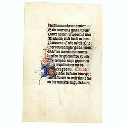
Manuscript leaf, on vellum from a book of hours.
The flesh side of the vellum has 4 large 1-line initial illuminated initials in blue and red with white heightening, on a very heavily burnished gold ground. 1 side illum...
Date: Paris, 1450
Manuscript leaf on vellum from a Dutch Book of Hours.
RECTO: Two 1-line capitals in red, blue or burnished gold with extensive penworkVERSO: One 1-line capitals in red, blue or burnished gold with extensive penwork.
Date: Flanders ca.1450
Manuscript leaf on vellum from a Dutch Book of Hours.
VERSO: One 1-line capitals in red, blue or burnished gold with extensive penwork.
Date: Flanders ca.1450
Leaf on vellum from a manuscript Book of Hours.
RECTO: Panel border of acanthus leaves and flowers on a partly liquid gold and dark red ground, one 2-line initial and one 1-line initial in liquid gold on colored ground...
Date: France, c.1450
Manuscript leaf on vellum from a Dutch Book of Hours.
A leaf from a medieval manuscript Book of Hours, written in Utrecht.Fourteen lines of monastic Textura script with 4 two-line initial "I" in liquid gold on a bl...
Date: Utrecht, ca.1450 - 1460
Manuscript leaf on vellum from a Dutch Book of Hours.
A leaf from a medieval manuscript Book of Hours, written in Utrecht.Fourteen lines of monastic Textura script with fourteen 1-line initials in blue or gold with extensive...
Date: Utrecht, ca.1450 - 1460
Manuscript leaf with 2-line illuminated capital L.
Fine leaf from a Book of Hours, Psalm 148 Veni Creator Spiritus, mentes tuorum visita imple superna gratia quae tu creasti pectora .. RECTO: One 3-line illuminated capita...
Date: Brugge, ca 1460
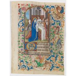
Miniature of the Presentation of Jesus at the Temple.
Page from a Book of Hours, use of Rome, with a large miniature set in full borders, by the Maitre François sub-group of Parisian artists of the middle of the second half...
Date: Paris ca. 1470
Leaf on vellum from a manuscript Book of Hours.
Charming small manuscript leaf from an French Book of Hours written around 1470 in or near Rouen.VERSO: 14 Lines of text in Latin five 1-lines initial in liquid gold on b...
Date: France, ca.1470
Leaf on vellum from a manuscript Book of Hours.
Leaf from a mid 15 th. century manuscript Book of Hours. Written on vellum in neat Gothic book hand.VERSO: 17 lines of text, with 2-line capital in red and blue, heighten...
Date: France ca.1470
Leaf on vellum from a manuscript Book of Hours.
Leaf from a mid 15 th. century manuscript Book of Hours. Written on vellum in neat Gothic book hand.RECTO: 17 lines of text, with 2-line capital in red and blue, heighten...
Date: France ca.1470
Leaf on vellum from a manuscript Book of Hours.
Leaf from a mid 15 th. century manuscript Book of Hours. Written on vellum in neat Gothic book hand.VERSO: 17 lines of text, with 2-line capital in red and blue, heighten...
Date: France ca.1470
Leaf on vellum from a manuscript Book of Hours.
14 Lines of text in Latin and three 1-line initials in blue on colored grounds.RECTO: 14 Lines of text in Latin and four 1-line initials in blue on colored grounds with l...
Date: France, ca.1470
Selling price: ????
Please login to see price!
Sold in 2025
Leaf on vellum from a manuscript Book of Hours.
14 Lines of text in Latin and three 1-line initials in blue on colored grounds.RECTO: 14 Lines of text in Latin and three 1-line initials in blue on colored grounds with ...
Date: France, ca.1470
A leaf from a breviary.
Two large 2-line initials in red and or blue for the start of the new chapter.Nice clean leaves, with ample margins, from a breviary, end of the 15th. century.
Date: Northern Netherlands ?, ca. 1480
A leaf from a breviary.
Two large 2-line initials in red and or blue for the start of the new chapter.Nice clean leaves, with ample margins, from a breviary, end of the 15th. century.
Date: Northern Netherlands ?, ca. 1480
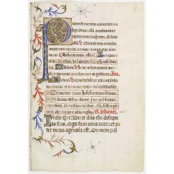
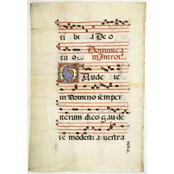
Leaf on vellum from an antiphonary.
A large vellum antiphonary leaf, written in Latin , probably Rome. RECTO: A wonderful initial "Q",, decorated with penwork in red, white and blue, in rich burni...
Date: Italy, 1480
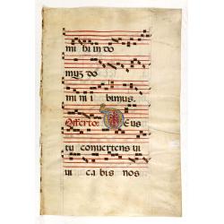
Leaf on vellum from an antiphonary.
A very fine antiphonary leaf, written in Latin, probably Rome. RECTO: The staves are in red and the notes are in black.VERSO: The staves are in red and the notes are in b...
Date: Italy, 1480
Leaf on vellum from an antiphonary.
A very fine antiphonary leaf, written in Latin , probably Rome. RECTO: A wonderful initial ,O, decorated with pen work in red, white and blue, in rich burnished gold.VERS...
Date: Italy, 1480
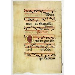
Leaf on vellum from an antiphonary.
A very fine antiphonary leaf, written in Latin , probably Rome. RECTO: The staves are in red and the notes in black.VERSO: Tw wonderful initial ,A and O, decorated with p...
Date: Italy, 1480
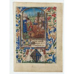
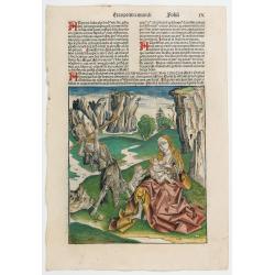
Miniature of Suffrages to the Saints.
A fantastic miniature (70 x 50 mm.) in an arched compartment showing the Suffrages to the Saints. Depiction of the (50) martyrs being burnt before the King's orders. The ...
Date: France, Bretagne or Normandy, c. 1480
Selling price: ????
Please login to see price!
Sold in 2024
Leaf on vellum from an antiphonary.
A very fine antiphonary leaf, written in Latin, probably Rome. RECTO: A wonderful initial "I" decorated with penwork in red, white and blue, in rich burnished g...
Date: Italy, 1480
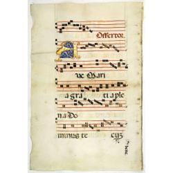
Leaf on vellum from an antiphonary.
A very fine antiphonary leaf, written in Latin , probably Rome. RECTO: The staves are in red and the notes in black. VERSO: The staves are in red and the notes in black. ...
Date: Italy, 1480
Leaf on vellum from a manuscript Book of Hours.
RECTO: Panel border of acanthus leaves and flowers on a partly liquid gold and dark red ground, height 1-line initial in liquid gold on colored grounds and three line fil...
Date: France, ca. 1420-1480
Leaf on vellum from a manuscript Brevier.
RECTO: One 3-line illuminated initial in burnished gold on colored grounds. Panel border of acanthus leaves, flowers and birds on a partly liquid gold and dark red ground...
Date: Tours, c.1485
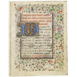
A manuscript leaf from a Book of Hours.
RECTO: One 2-line and eight 1-line initials in liquid gold on colored grounds and five line-fillers. colorful panel border in he right margin of acanthus leaves and flowe...
Date: Italy, ca. 1490
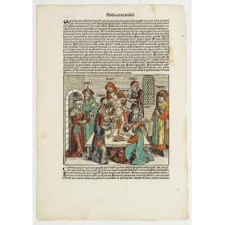
Quinta Etas Mundi. Folium. LXVI. (Visionary Temple of Ezekiel.)
The Latin text page is illustrated with recto and verso depictions of the visionary Temple of Ezekiel. Kings.Page from the richest illustrated Incunable, the famous: Chro...
Date: Nuremberg, 12 July 1493
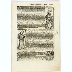
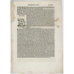
Sexta etas mundi. CCVIII
On recto the portrait of Dominic, founder of the Dominican Order of Preaching Friars, is represented by a full-length woodcut. Francis, founder of the Franciscan Order, i...
Date: Nuremberg, 12 July 1493
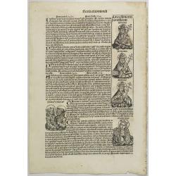
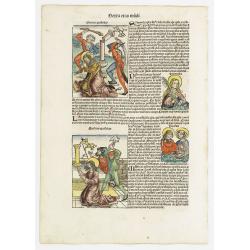
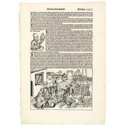
Text page with Kings, Queens, Saints and Popes. Sexta Etas Mundi. Folium. CXVI.
Recto verso text page with woodcuts of Kings, Queens, Saints (St.Cecilia), Popes and historical personalities. Page from the richest illustrated Incunable, the famous ...
Date: Nuremberg, 12 July 1493
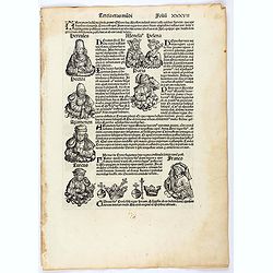
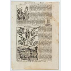
Tercia Etas Mundi. Folium. XXXVII
The Latin text page is illustrated with a depictions of Kings, Noble men and women and scientists. Page from the richest illustrated Incunable, the famous: Nuremberg Chro...
Date: Nuremberg, 12 July 1493
![Quarta Etas Mndi. Carvilium / Aquileya. [Carovilli and Aquileia]](/uploads/cache/13525-250x250.jpg)
Quarta Etas Mndi. Carvilium / Aquileya. [Carovilli and Aquileia]
A lovely presentation of Carovilli, in the province of Cremona. Recto, a view of the town of Aquileya in Italy, centered on the castle and the high walls. Aquileia is an ...
Date: Nuremberg, 12 July 1493
Selling price: ????
Please login to see price!
Sold in 2026
![[Text page with Kings and historical personalities.] Quita etas mundi. Foliu. LXXXIII](/uploads/cache/26874-250x250.jpg)
[Text page with Kings and historical personalities.] Quita etas mundi. Foliu. LXXXIII
Text page with woodcuts of Kings and historical personalities.Page from the richest illustrated Incunable, the famous: Nuremberg Chronicle, published the year that Columb...
Date: Nuremberg, 12 July 1493
![[ Secunda etas mundi. Foliu XVIII ].](/uploads/cache/26866-250x250.jpg)
[ Secunda etas mundi. Foliu XVIII ].
Text in Latin, each paragraph separated by the triumphant cross with orb representing Christ's reign over the world (it is often shown atop Christ's scepter in Christian ...
Date: Nuremberg, 12 July 1493
![[Page with imaginary towns in Hungary. ] CCLXVIII](/uploads/cache/26932-250x250.jpg)
[Page with imaginary towns in Hungary. ] CCLXVIII
Page with imaginary towns in Hungary (230x225mm.) This leaf is from an edition of Hartmann Schedel's Liber chronicarum or Nuremberg Chronicle. The Chronicle was published...
Date: Nuremberg, 1493
![[Text page with Saint Appolonia, the patron saint of dentistry. - Sexta Etas Mundi. Folium. CXX ].](/uploads/cache/26526-250x250.jpg)
[Text page with Saint Appolonia, the patron saint of dentistry. - Sexta Etas Mundi. Folium. CXX ].
Text page with woodcuts of Abdon & Senen, Agatha, Appolonia, Serapion, Meniacus, Victoria. With a woodcut of Appolonia, the patron saint of dentistry. Because of the ...
Date: Nuremberg, 12 July 1493
![Bamberga. Folium CLXXV [Bamberg]](/uploads/cache/47606-250x250.jpg)
Bamberga. Folium CLXXV [Bamberg]
Double page panoramic view of Bamberg. One of the earliest obtainable views of this period.Two pages from the richest illustrated Incunable, the famous Nuremberg Chronic...
Date: Nuremberg, 12 July 1493
![Madeburga [ Maagdenburg Folio CLXXX ]](/uploads/cache/47601-250x250.jpg)
Madeburga [ Maagdenburg Folio CLXXX ]
Double page panoramic view of Magdeburg. A imaginary view, however the earliest obtainable view of this period.Two page from the richest illustrated Incunable, the famous...
Date: Nuremberg, 12 July 1493
![Tertia Etas Mundi. Folium. CI [Woodcut of Jesus and his apostles]](/uploads/cache/48519-250x250.jpg)
Tertia Etas Mundi. Folium. CI [Woodcut of Jesus and his apostles]
The Latin text page is illustrated with a depictions of Kings, Noble men and women and scientists. VERSO : A full page woodcut showing Jesus and his apostles.(360x221mm.)...
Date: Nuremberg, 12 July 1493
![Carthage, etc. [Foliu XL ] Carthage in Tunisia](/uploads/cache/26122-250x250.jpg)
Carthage, etc. [Foliu XL ] Carthage in Tunisia
VERSO: Portraits of scholars, and an imaginary view on Carthage in Tunisia (12x17cm.) Page from the famous Liber chronicarum of Hartmann-Schedel 1493, the first and Latin...
Date: Nuremberg 12 July 1493
![Ulma Folio CXCI [With view of Ulm.]](/uploads/cache/29713-250x250.jpg)
Ulma Folio CXCI [With view of Ulm.]
Double-page panoramic view of Ulm.An imaginary view, however, is the earliest obtainable view of this period.Two pages from the richest illustrated Incunabel, the famou...
Date: Nuremberg, 12 July 1493
![Basilae [ Basle, CCXLIIII ]](/uploads/cache/29714-250x250.jpg)
Basilae [ Basle, CCXLIIII ]
A very fine view of Basle (253x520 cm). Verso showing the councils of Florence and Basle and two portraits.Page from the richest illustrated Incunabel, the famous Nuremb...
Date: Nuremberg, 12 July 1493
![Venecie. [Venice] Foliu XLIIII](/uploads/cache/29716-250x250.jpg)
Venecie. [Venice] Foliu XLIIII
A very fine of Venice (192x525mm.) Verso a view of Padua. Schedel's view of Venice is one of the earliest obtainable views of the city. The view is based on the view of ...
Date: Nuremberg, 12 July 1493
Prima Etas Mundi. IX (with Eve nursing Kain and Abel)
A very fine presentation of Eve nursing Kain and Abel. Adam is working (255x220 cm). VERSO a genealogy of Adam.Page from the richest illustrated Incunabel, the famous: Li...
Date: Nuremberg, 12 July 1493
![Sexta Etas Mundi. Foliu CXXXV [Text page with S. Hieronymus, the patron of theological learning].](/uploads/cache/25763-250x250.jpg)
Sexta Etas Mundi. Foliu CXXXV [Text page with S. Hieronymus, the patron of theological learning].
Text page with woodcuts of the following saints: S. Hieronymus, the patron of theological learning (100x80mm.)VERSO is printed with text and images of Popes and Kings.Pag...
Date: Nuremberg, 12 July 1493
![Tercia Etas Mundi. Folium XXX. [The flight of Egypt, Moses receiving the Commandments, God's Angel, Balaam and his talking donkey. ]](/uploads/cache/29854-250x250.jpg)
Tercia Etas Mundi. Folium XXX. [The flight of Egypt, Moses receiving the Commandments, God's Angel, Balaam and his talking donkey. ]
On recto two nice woodblock prints (each 128x222mm.) of The flight of Egypt and Moses receiving the Commandments.VERSO : a woodblock print of God's Angel, Balaam and his ...
Date: Nuremberg, 12 July 1493
![Etas Prima Mundi. Folium VII. [Adam and Eve, eating the apple and being expelled from paradise]](/uploads/cache/29855-250x250.jpg)
Etas Prima Mundi. Folium VII. [Adam and Eve, eating the apple and being expelled from paradise]
Latin text page with a large woodcut of Adam and Eve, eating the apple and being expelled from paradise.One of the most sought-after prints from the richest illustrated I...
Date: Nuremberg, 12 July 1493

Secunda etas mundi. Folium XIII.
Schedel's world map was based on the cartographic system of Claudius Ptolemy, the great second-century AD geographer whose scholarship formed the foundation for map produ...
Date: Nuremberg, 12 July 1493

(EUROPE).
A woodcut colored map of northern and central Europe. The first modern map of the area. Second printed map of the North, after the woodcut map published in the 'Ulm' Ptol...
Date: Nuremberg, 1493
![[The creation of the world - First day]](/uploads/cache/24509-250x250.jpg)
[The creation of the world - First day]
Attractive page from the Nuremberg Chronicle, showing the creation of the world: the First Day, showing the celestial choir (God\'s creation of the angels) surrounding th...
Date: Nuremberg, 12 July 1493
Sexta etas Mundi. Folium. CCXLV
The Latin text page is illustrated with a depiction of two lovers who happened to have lived in Italy: a knight named Eurialus, who was the personal attendant of Emperor ...
Date: Nuremberg, 12 July 1493
Sexta Etas Mudi. / Simon Beatus .. / Folio CCLIIII.
A very fine presentation of the circumcision of Simon (192 x 223 mm.). RECTO: a falling star, a portrait of a King and an officer wearing armour. Page from the richest il...
Date: Nuremberg, 12 July 1493
Selling price: ????
Please login to see price!
Sold in 2026
Sexta Etas Mudi. Symon Apostolus.. Folio CVII.
A very nice presentation of the martyr of Simon, sawn in half at Suanir, and Mathias stoned to death at Colchis in 80 AD. Overleaf, it shows the martyr of Matthew and Jud...
Date: Nuremberg, 12 July 1493
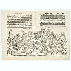
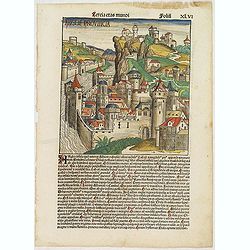
Destruccio Iherosolime.
The view shows the destruction of Jerusalem. Major points in the city are identified with Latin notations. Of interest, in the upper left of the image are two figures...
Date: Nuremberg, 12 July 1493
Sexta Etas Mudi. Folio CCLV. (With portret of Johannes Müller alias Regiomontanus holding a Astrolabe.
A very fine presentation of the astronomer Johannes Müller alias Regiomontanus holding a Astrolabe. A village-scene (Dim. H : 150 mm W : 223 mm) is depicted on the lower...
Date: Nuremberg, 12 July 1493
![Venecie. [Venice] Foliu XLIIII.](/uploads/cache/49420-250x250.jpg)
Venecie. [Venice] Foliu XLIIII.
A very fine panoramic view of Venice (192x525mm.) Verso a view of Padua. Schedel's view of Venice is one of the earliest obtainable views of the city. The view is based o...
Date: Nuremberg, 12 July 1493

Sexta Etas Mundi. Folium. CCXVII (dancers of Maastricht).
Latin text page with woodcuts of male Siamese twins, a man headed lion. The large illustration is the only illustration related to the Netherlands : it shows a bridge col...
Date: Nuremberg, 12 July 1493
Selling price: ????
Please login to see price!
Sold in 2024
![Sexta Etas Mundi. Ratisbonna. [Ratisbonne]](/uploads/cache/13549-250x250.jpg)
Sexta Etas Mundi. Ratisbonna. [Ratisbonne]
A very fine presentation of the city of Ratisbon, in Germany, centered on the cathedral (Dim. : 191 mm W : 525 mm).Overleaf a very nice view of Vienna, with two swans on ...
Date: Nuremberg, 12 July 1493
![Sexta Etas Mundi. Constancia. [Constance CCXLI ]](/uploads/cache/33141-250x250.jpg)
Sexta Etas Mundi. Constancia. [Constance CCXLI ]
A very fine town view of Constance, in Germany, centered on the cathedral (198 x 520 mm).VERSO, seven insets of scientists, noblemen and Popes.Page from the richest illus...
Date: Nuremberg, 12 July 1493
Prima Etas Mundi. VI
A very fine presentation of Eve, being created by God from Adam’s side.Page from the richest illustrated Incunable, the famous: Nuremberg Chronicle, published the year ...
Date: Nuremberg, 12 July 1493

Prima Etas Mundi. IX
A very fine presentation of Eve nursing Kain and Abel. Adam is working (255x220 cm). VERSO: A Genealogy of Adam.Page from the richest illustrated Incunabel, the famous L...
Date: Nuremberg, 12 July 1493
Sexta Etas Mudi. Lucas Evagelista. Folium CVIII.
A very nice presentation of Lucas the Evangelist (100x80mm.) and the representation of Maria Magdalena held by angels 210x135mm.).VERSO : Showing the line of the popes Cl...
Date: Nuremberg, 12 July 1493
Tercia Etas Mundi. Folium.XLVI (An English town view)
Large woodcut depicting an imaginary English town (235x223mm.) and on the verso the genealogy of King David.Page from the richest illustrated Incunable, the famous: Chron...
Date: Nuremberg, 12 July 1493

(EUROPE).
The map of Europe has been identified as the work of Hieronimus Münzer (1437-1508), a Nuremberg physician who supplied the geographical contents of the chronicle. The Eu...
Date: Nuremberg, 1493
Quita etas Mundi Folium XCIIII
The Latin text page is illustrated with a depictions of Kings, Noble men and women and scientists, like Strabo, a historian, geographer and philosopher. Mother Mary and Z...
Date: Nuremberg, 12 July 1493
Sexta Etas Mundi. Folium. CXXV
Latin text page with woodcuts on recto and verso of Saints, Kings, and Queens. Including Lucia (Lucia Martyr) is represented with a nimbus and crown of martyrdom. A sword...
Date: Nuremberg, 12 July 1493
Quinta Etas Mundi. Folium.XCIII.
The Latin text page is illustrated with depictions of Caius Julius Caesar, Octavian (Octavianus) Augustus and Mark Antony (Marcus Antonius). VERSO : A wonderful woodcut (...
Date: Nuremberg, 12 July 1493
![Madeburga [ Maagdenburg Folio CLXXX ]](/uploads/cache/12338-250x250.jpg)
Madeburga [ Maagdenburg Folio CLXXX ]
Double-page panoramic view of Magdeburg. A imaginary view, however the earliest obtainable view of this period.Two page from the richest illustrated Incunable, the famous...
Date: Nuremberg, 12 July 1493
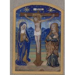
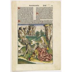
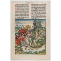
Miniature of The Crucifixion of Christ.
Page fragment from a Book of Hours with a miniature of the Cruxifiction with Saint Mary and Mary Magdalene in prayer in front of Jesus hung on the cross. This miniature c...
Date: Paris, 1492 - 1494