Browse Listings
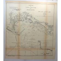
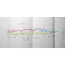
Sketch of Plan and Sections of a Breakwater, San Luis Obispo Bay, Cal. 1876.
A scarce early map of the San Luis Obispo area of California. It is one of the earliest obtainable plans of San Luis Obispo. Showing the town, mountains several rivers an...
Place & Date: Washington, 1878
Selling price: $125
Sold in 2018
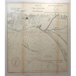
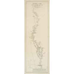
Sketch of Plan and Section of a Breakwater, San Buenaventura, Cal. 1870.
A scarce early map of Ventura, extending from the San Buenaventura River and the City of Ventura southward. Showing the town, mountains several rivers and extensive sound...
Place & Date: Washington, 1878
Selling price: $240
Sold in 2018
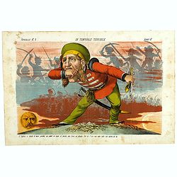
Un Temporale terribile. Papagallo No. 2. Anno VI.
Showing an English figure standing on British and American soil. Design by Augusto Grossi. Taken from the Italian satirical newspaper Il Papagallo, a satirical magazine f...
Place & Date: Bologne, 1878
Selling price: $195
Sold in 2019

Rivista Aereostatica. Papagallo No. 30. Anno VI.
Balloons showing the different European nations. Design by Augusto Grossi. Taken from the Italian satirical newspaper Il Papagallo, a satirical magazine founded in Januar...
Place & Date: Bologne, 1878
Selling price: $195
Sold in 2018
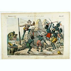
Un Reclutatore in India. Papagallo No. 42. Anno VI.
British in India. Design by Augusto Grossi. Taken from the Italian satirical newspaper Il Papagallo, a satirical magazine founded in January 1873 by Augusto Grossi (1835-...
Place & Date: Bologne, 1878
Selling price: $195
Sold in 2019
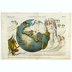
Allegoria sull'Impero Inglese. Papagallo No. 50. Anno VI.
This lithographed plate depicts the terrestrial globe enclosed by a giant snake with a half-human, half-animal head whose tail carries the British flag. The head covers t...
Place & Date: Bologne, 1878
Selling price: $2250
Sold in 2018
Allegoria sull'Impero Inglese. Papagallo No. 50. Anno VI.
This lithographed plate depicts the terrestrial globe enclosed by a giant snake with a half-human, half-animal head whose tail carries the British flag. The head covers t...
Place & Date: Bologne, 1878
Selling price: $1950
Sold in 2019
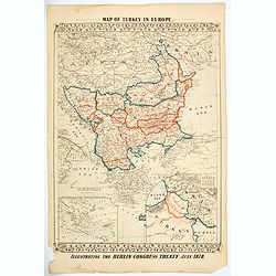
Map of Turkey in Europe. Illustrating the Berlin CongressTtreaty, July 1878.
An unusual map of Turkey, Greece, the Balkans, Austria and a part of the Ukraine, illustrating the nations created under the Berlin Congress Treaty, as well as the lands ...
Place & Date: Philadelphia, 1878
Selling price: $50
Sold in 2021
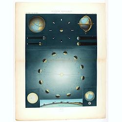
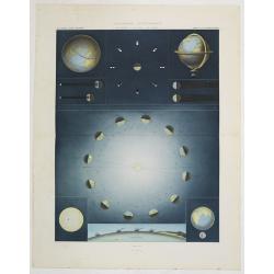
Géographie astronomique - la Terre - la Lune - le Soleil.
Celestial chart published in Paris in 1878 in "Atlas Universel" by Vivien de Saint Martin. Printed by Chardon aîné. Shows the revolution of the Earth and the ...
Place & Date: Paris, Chardon aîné, 1878
Selling price: $220
Sold in 2020
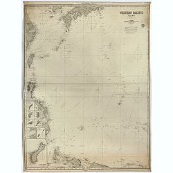
Western Pacific (Chart n°4), 1877 ( Ink stamp Imray and son London 1878)
Printed in lithography and pasted on blue paper. Generally very good condition. Published by Imray, 89 & 102 Minories, London 1864. In the upper margin, "Western...
Place & Date: London, 1864,1877, 1878
Selling price: $650
Sold in 2023
Grand Atlas Universel, troisième édition.
William Hughes Grand Atlas Universel, troisième édition, illustrated with 51 color-printed double-page maps, including 2 world maps, with one original hand-colored map ...
Place & Date: Paris, J. Rothschild, 1877-1878
Selling price: $480
Sold
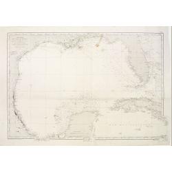
Carte générale du Golfe du Mexique d'après les traveaux Américans, Anglais et Français les plus récents. Publiée par ordre de L'Empereur..
Important chart of Texas, Florida and the Gulf Coast, heavenly leaning on the landmark map Carta Esferica. The original map was commissioned by the governor of Spanish Lo...
Place & Date: Paris (1865) corrected for 1878
Selling price: $800
Sold
Géographie Universelle, Atlas Migeon ... Géographes Historique, Scientifique, Industriel et Commercial. . .
Early edition of this popular French atlas with 42 engraved and hand-colored double-page maps, many with insets and/or engraved vignettes, decorative double-page title pa...
Place & Date: Paris, 1878
Selling price: $500
Sold in 2015
Géographie astronomique. La terre - la lune - le soleil.
Very decorative plate showing the different positions of the earth during the year in relation to the sun. Showing the proportions of earth and moon, and moon and sun, da...
Place & Date: Paris, Hachette & Comp., 1878
Selling price: $400
Sold in 2013

Cabinet de toilette Louis XVI.
Very decorative and colorful lithography of an elegant French interior. From La Tenture Française, published by G.Mathière, 32/34 Rue de Charonne, Paris.
Place & Date: Paris, 1879
Selling price: $20
Sold in 2023

Lit Louis XV
Very decorative and colorful lithography of an elegant French interior. From La Tenture Française, published by G.Mathière, 32/34 Rue de Charonne, Paris.
Place & Date: Paris 1879
Selling price: $60
Sold
Royaume de Siam - Cours du Fleuve Me - Nam..
Detailed missionary map illustrating the course of the Menam [Chao Phraya] river in today Thailand. With short legend in the lower left corner.Engraved in stone by R. Hau...
Place & Date: Paris 1878 - 1879
Selling price: $240
Sold
Carte particulière des cotes de France Dept. du Var...
Very large sea chart of a part of the Provence - Côte d'Azur region. From Hyères to Cap Camarat. Includes Ile de Porquerolles, Port-Cros, Ile du Levant. Dated 1843 but ...
Place & Date: Paris, 1879
Selling price: $81
Sold in 2016
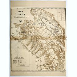
Carta de la Hoya del Lago Titicaca...Oceano Pacifico.
Map of the region surrounding Lake Titicaca in Peru. Map shows roads, railways, major, and minor towns, mineral mines, and the physical geography of the region. Map has a...
Place & Date: Santiago, 1879
Selling price: $75
Sold in 2016
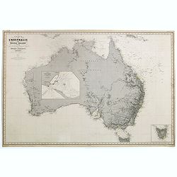
Carte de l'Australie ou Nouvelle Hollande dressée d'aprés les derniers documents Anglais par Robiquet, Hydrographe, . . .
A of the Australia, with its islands and adjacent coasts in detail.
Place & Date: Paris, 1879
Selling price: $600
Sold in 2019
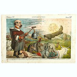
Un ex Sant'Antonio. CONTE. Ja! ja! Bestie malvagie! un tempo ascoltavate la mia benedizione, oggi mi voltate le spalle per guardare al nuovo astro. Badate, in quell'atro si producono i pipistrelli. . Papagallo N°3. Anno VII
Design by Augusto Grossi. Taken from the Italian satirical newspaper Il Papagallo, a satirical magazine founded in January 1873 by Augusto Grossi (1835-1919), which speci...
Place & Date: Bologne, 1879
Selling price: $195
Sold
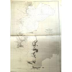
Unusual Chart Of the Tokyo Yokohama Bay.
"Golfe de Yedo" le sud du Japon" d'aprés l'amirauté Britannique. 1872 corrections in 1876-78-79. Dépôt général de la marine. 1 x tearing paper off ma...
Place & Date: Paris, 1879
Selling price: $380
Sold in 2021
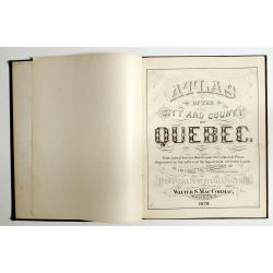
Atlas of the city and county of Quebec from actual surveys, based upon the cadastral plans deposited in the office of the Department of Crown Lands.
This scarce city atlas of Quebec is illustrated with 18 hand-colored maps made by Henry Whitmer, 1838-1920. The atlas contains 12 maps of Parishes, 5 maps of Quebec by ...
Place & Date: Provincial Surveying and Pub. Co., Walter, S, MacCormac, manager,1879
Selling price: $850
Sold in 2023
![Zoological Geography.. Birds of Europe [and] over the World. Phytology & Zoology No. 6.](/uploads/cache/1152772-250x250.jpg)
Zoological Geography.. Birds of Europe [and] over the World. Phytology & Zoology No. 6.
Original double-page engraved map (overall 55 x 66 cm.), with light original hand-coloring. As issued in The Physical Atlas... by Alexander Keth Johnstone... based on the...
Place & Date: Edinburgh, Glasgow, ca. 1880
Selling price: $130
Sold in 2020
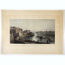
Malta, entrance to the great harbour.
Engraving of Malta harbor, drawn by A. Duncan and engraved by J. Godfrey.
Place & Date: London, ca. 1880
Selling price: $101
Sold in 2021
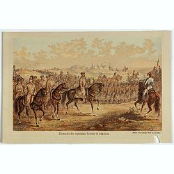
Einmarsch der russischen truppen in Romänien.
Showing the Russian arriving in Romaniia during the Russian-Turkish War (1828-1829) . Russian troops occupied Wallachia and Moldova for a few years.
Place & Date: Dresden, 1880
Selling price: $10
Sold in 2023
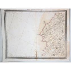
N 151. Partie de Portugal.
A lithographic atlas map, hand-colored in outline, on a conical projection. This map by Vandermaelen was published within the first atlas ever to be printed using lithogr...
Place & Date: Brussells, 1880
Selling price: $17
Sold in 2021
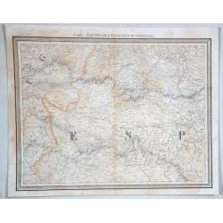
No 132 Parties de L'espagme et du Portugal.
Antique folio-sized lithographic atlas map, hand colored in outline, on a conical projection. This map by Vandermaelen was published within the first atlas ever to be pri...
Place & Date: Brussells, 1880
Selling price: $30
Sold in 2021
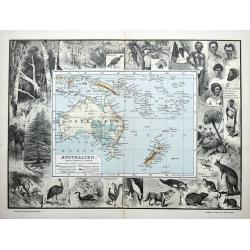
Australien.
An unusual German map of Australia surrounded by numerous images of birds, animals, and trees. Also shows aborigines and inhabitants of New Guinea, New Zealand, Samoa, Ne...
Place & Date: Leipzig, ca 1880
Selling price: $190
Sold in 2021
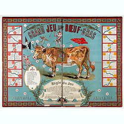
Le bœuf-gras. (Boardgame).
Rare boardgame named "The big game of the fat ox". The celebration of the fat ox was a central custom of the Paris Carnival, which was held at mid-Lent, a perio...
Place & Date: Paris, ca. 1880
Selling price: $600
Sold in 2022
![[Untitled - Le Voyage Autour du Monde en 80 jours: d'apres le Romain de Jules Verne.]](/uploads/cache/48134-250x250.jpg)
[Untitled - Le Voyage Autour du Monde en 80 jours: d'apres le Romain de Jules Verne.]
This lovely children's games of the novel by Jules Verne game is without its illustrated box, six little hand-painted lead playing pieces (modeled on characters in the no...
Place & Date: Paris, ca 1880
Selling price: $350
Sold in 2022
![[Lot of 12 maps and prints relating to Surinam and South America and map of The Netherlands]](/uploads/cache/48306-250x250.jpg)
[Lot of 12 maps and prints relating to Surinam and South America and map of The Netherlands]
A lot of 12 maps and prints of Surinam, South America and one of the Netherlands. Including Bellin's maps of "Carte de l'Isle de Cayenne et de ses Environs (205x285m...
Place & Date: Netherlands, Paris, ca. 1700-1880
Selling price: $100
Sold in 2022
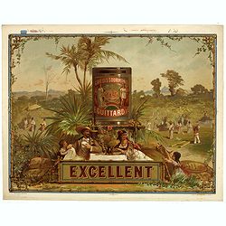
Café des gourmands E. Guittard - Excellent.
Original chromo lithographed coffee advertising poster by Gonthier-Dreyfus & Co., for E. Guittard & Co. The company was started by Eddy Guittard, who emigrated fr...
Place & Date: Paris, ca. 1880
Selling price: $380
Sold in 2023

Chinese painting on silk.
Fine oriental miniature of a Chinese couple engaged in amorous pursuit. Quin Dynasty, late 19th. century.This type of Chinese painting, usually anonymous, also called &qu...
Place & Date: China, ca. 1880
Selling price: $175
Sold in 2022

Chambre a coucher Louis XV.
Very decorative and colorful lithography of an elegant French interior. From "La Tenture FranÇaise, published by G.Mathière, 32/34 Rue de Charonne, Paris.
Place & Date: Paris 1880
Selling price: $40
Sold
![[no title] Australia, New Zealand, Indonesia, Africa, etc.](/uploads/cache/15711-250x250.jpg)
[no title] Australia, New Zealand, Indonesia, Africa, etc.
Detailed chart of south Africa and Australia, new Zealand and a tip of Antarctica. Updated till 1880.
Place & Date: Paris 1874/1880
Selling price: $400
Sold in 2010
Full set with cut out figures.
An early and dvry decorative example of a full sheet intended to illuminate poem books made by children.The page shows young boys in a medieval style outfit, presenting f...
Place & Date: France/ Germany c.1880
Selling price: $60
Sold

Full set with cut out figures.
An early and very decorative example of a full sheet intended to illuminate poem books made by children.The page shows 22 fishes.
Place & Date: France/ Germany c.1880
Selling price: $60
Sold

Full set with cut out figures.
An early and very decorative example of a full sheet intended to illuminate poem books made by children.The page shows different type of fishes and lobster.
Place & Date: France/ Germany c.1880
Selling price: $60
Sold

Siéges de bureau empire.
Very decorative and colorful lithography of an elegant French interior. From La Tenture Française, published by G.Mathière, 32/34 Rue de Charonne, Paris.
Place & Date: Paris, 1880
Selling price: $25
Sold in 2023
![[Map puzzle] Atlas.](/uploads/cache/16638-250x250.jpg)
[Map puzzle] Atlas.
A uncommon geographic Jigsaw puzzle. With a double hemisphere world map, Europe and France. The maps used for the puzzle are geographically sophisticated and well engrave...
Place & Date: Paris 1880
Selling price: $100
Sold

Bien antique, mais, hélas! .. Elle est indéchiffrable. L'ANTIQUAIRE.
Decorative caricature of an antique dealer.
Place & Date: Paris 1880
Selling price: $120
Sold
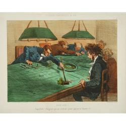
Rouge perd !!!
Sub title: Saperlote ! l'argent qui me restait pour à l'hotel !!! . Plate no.9 from Souvenirs Charivariques de spa . Printed by Bertauts, rue Cadet, Paris. Lithographed ...
Place & Date: Paris 1880
Selling price: $105
Sold
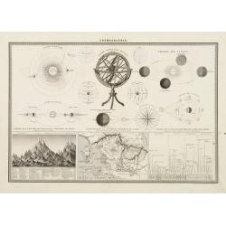
Armillary Sphere.
Very fine print of a typical 19th century armillary sphere. Ecliptic with named zodiac and calendar scales. Lower part 3 inset maps one with mountains heights.
Place & Date: Paris, 1880
Selling price: $40
Sold in 2013
Carte .. De la Patagonie et de la Terre de Feu..
Very detailed map of Strait of Magellan, prepared by J.Grange.Engraved by Jacobs. With a color key to soil conditions.
Place & Date: Paris c.1880
Selling price: $100
Sold
![Collection of prints of Castors. [10 prints]](/uploads/cache/13484-250x250.jpg)
Collection of prints of Castors. [10 prints]
A group of 10 decorative prints mainly after Georges-Louis Leclerc, comte de BUFFON, this great naturalist (1707-88) spent the greater part of his life at his chateau de ...
Place & Date: France, 1812-1880
Selling price: $40
Sold in 2011

Un Mauvais Joueur.
Sub title: Croupier de malheur ! voici encore pour toi! . Plate no.12 from Souvenirs Charivariques de spa .Printed by Bertauts, rue Cadet, Paris. Lithographed by Amédée...
Place & Date: Paris 1880
Selling price: $120
Sold

Cathédrale des Patriarches, (Saints Apôtres) intérieur du Kremlin.
Beautiful lithography of the Cathédrale des Patriarches in Kremlin, Moscow.
Place & Date: Paris, ca. 1880
Selling price: $50
Sold in 2009
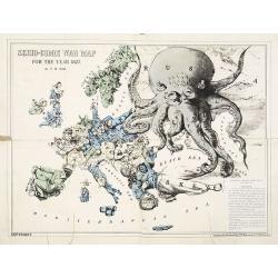
Serio-Comic War Map For The Year 1877.
Fascinating political caricature map by Frederick Rose, printed by G. W. Bacon & Co., a bygone U.K. publisher of maps and atlases, of the countries of Europe, known a...
Place & Date: London, 1877-1880
Selling price: $800
Sold in 2009
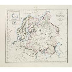
Nord de l'Europe Russie Suède -Denemach- Physique. Etude 19.
Map of the North of Europe including Russia, Sweden and Denmark with two inset maps of Island and the Danish Faeroe Islands.
Place & Date: Paris, c. 1880
Selling price: $80
Sold in 2010
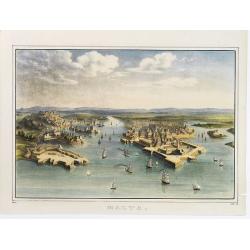
Malta.
A bird's eye view of Malta with many ships entering the port.
Place & Date: c.1880
Selling price: $225
Sold in 2012
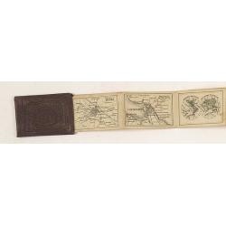
Russian Miniature Atlas
Charming miniature Russian atlas of the world. Blind stamped red linen cover and 20 maps and plans in leporello form. Including a plan of Moscow, St. Petersburg, world, E...
Place & Date: Russia, c.1880
Selling price: $650
Sold in 2010
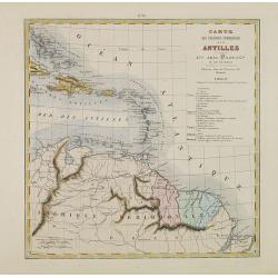
Carte des Colonies Françaises aux Antilles.
Uncommon map including Venezuela, French Guiana, Suriname, and the islands in the Caribbean. With a color key to the French, English, Spanish, Dutch and Danish possession...
Place & Date: Paris, Abel Pilon & Co., c.1880
Selling price: $75
Sold in 2012
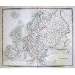
Europe.
Map of Europe.
Place & Date: Edinburgh, 1880
Selling price: $1
Sold in 2010
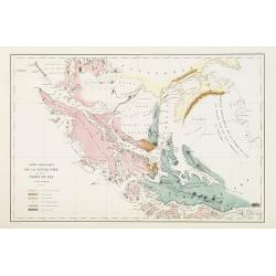
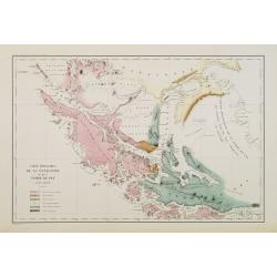
Carte géologique de la Patagonie et de la Terre de Feu.
Very detailed geological map of Strait of Magellan, prepared by J.Grange.Engraved by Jacobs. With a color key to soil conditions.From "Voyage au Pôle Sud et dans l'...
Place & Date: Paris c.1880
Selling price: $400
Sold in 2010
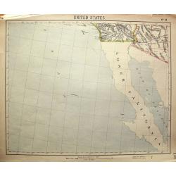
United States No. 19.
Unusual map, showing Baja California, and the area to San Diego, Santa Catalina Island, Yuma, Phoenix. Attractive map, with decorative coloring.
Place & Date: London, c1880
Selling price: $8
Sold in 2011
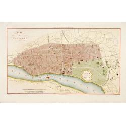
Plan de Calcutta.
Detailed plan of Calcutta, engraved by F. Dien and published in "Voyage aux Indes Orientales" de Charles Belanger.
Place & Date: Paris, c.1880
Selling price: $200
Sold in 2015
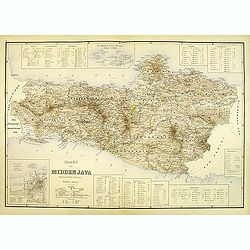
Kaart van midden Java. (tweede militaire afdeling)
Large map of central Java.
Place & Date: The Hague, c. 1880
Selling price: $250
Sold in 2012
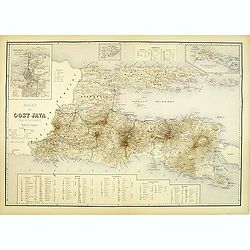
Kaart van oost Java. (derde militaire afdeling)
Large map of east Java.
Place & Date: The Hague, c. 1880
Selling price: $250
Sold in 2012
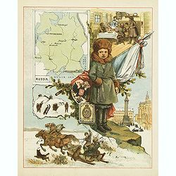
(Russia)
This color lithography carries in the upper left corner a map of European Russia with several towns mentioned. In the center a child and further decorated with flag, coat...
Place & Date: c. 1880
Selling price: $100
Sold in 2012
![Portrait de la Ville, Cité et Université de Paris avec les Faubourgs di celle dédié au Roy. [photogravure facsimile from 1880]](/uploads/cache/32083-250x250.jpg)
Portrait de la Ville, Cité et Université de Paris avec les Faubourgs di celle dédié au Roy. [photogravure facsimile from 1880]
This very fine photogravure plate is showing Paris at medieval times after Nicolay. This late 19th century and slightly reduced facsimile of this famous and very rare pla...
Place & Date: Paris, c.1880
Selling price: $1900
Sold
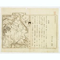
Japanese map of Central part of Europe with Black Sea and Ukraine.
Japanese map of Central part of Europe with Black Sea and Ukraine, with a description to the right.
Place & Date: Japan, ca. 1880
Selling price: $200
Sold in 2012
(Set of 4 maps) Itinéraire de Pékin à Sartchy
Set of 4 geological maps.
Place & Date: Paris, ca. 1880
Selling price: $50
Sold in 2019
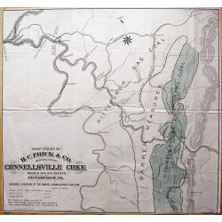
Map Issued by H.C. Frick & Co., Manufacturers Connellsville Coke.
Scarce large-scale map of the Connellsville coal vein by the H.C. Frick Coke Company. Locates ovens, towns, railroads, roads, creeks, etc. We could not locate a copy of ...
Place & Date: Pittsburgh, 1880
Selling price: $150
Sold in 2013
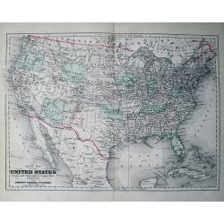
Map of the United States Drawn and Engraved on Copper-Plate Expressly for Johnson's Universal Cyclopaedia.
Fine map of the United States. Oklahoma is Indian Territory and only "one" Dakota. With many place names, railroads, etc.
Place & Date: New York, c1880
Selling price: $46
Sold in 2013
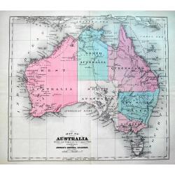
Map of Australia Drawn and Engraved On Copper-Plate Expressly for Johnson's Universal Cyclopaedia.
Fine map of Australia with attractive coloring. With interesting detail, indicating the routes of the expeditions of Gregory in 1856, Stuart in 1860, and Burke & Will...
Place & Date: New York, c1880
Selling price: $2
Sold in 2013
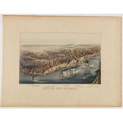
City of New Orleans.
A very decorative bird's-eye view of New Orleans with the Mississippi River in the foreground. Lake Pontchartrain is visible in the distance. Keyed below image : Lake Pon...
Place & Date: New York, ca. 1880
Selling price: $800
Sold in 2014

The Steam-Ship Alaska.
A fine Currier & Ives chromolithographic print featuring the steam-ship Alaska of the Guion Line. Its nickname was "THE GREYHOUND OF THE ATLANTIC." This pri...
Place & Date: New York, ca. 1880
Selling price: $69
Sold in 2016
Carte de la Route de Wilna à Moscou.
Detailed road map of the European part of Russia, centered on Minsk, Smolensk and Moscow in the upper right corner, prepared by A. H. Basset, rue Saint-Jacques, no. 55, P...
Place & Date: Paris, 1880
Selling price: $25
Sold in 2023
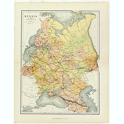
Russia in Europe with Transcaucasia.
Charming late map of Russia.
Place & Date: London, 1880
Selling price: $15
Sold in 2018
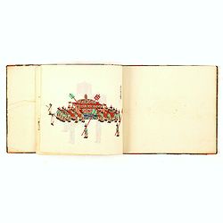
Chinese export album with 12 drawings.
Chinese export painting album with 12 drawings.
Place & Date: Peking, 1880
Selling price: $800
Sold in 2016
![[LOT OF 4 MAPS] Australia.](/uploads/cache/97310-250x250.jpg)
[LOT OF 4 MAPS] Australia.
Set of five 19th century maps on four sheets: 1) Australia. On backside: Physical map of Australasia. J. Bartholomew ca. 1880. 2) Australia & New Zealand. J. Barthol...
Place & Date: 1840-1880
Selling price: $11
Sold in 2016
![[LOT OF 3 MAPS] New Zealand](/uploads/cache/97311-250x250.jpg)
[LOT OF 3 MAPS] New Zealand
A set of three 19th century maps:1) New Zealand. J. Bartholomew ca. 1880.2) New Zealand. unknown ca. 1870?3) New Zealand and the Australian colonies of Great Britain by V...
Place & Date: 1840-1880
Selling price: $2
Sold in 2016
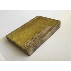
Ju Hachi Shiryaku - Summaries of the 18 eras.
A wonderful atlas of Chinese maps, showing the geographic extent of various Chinese dynasties. 10 double page woodblock maps of China. Meiji 12 (1880) the text is in Japa...
Place & Date: 1880
Selling price: $210
Sold in 2016

Sketches in Russia: Popular life and manners.
Six images on one plate of Russian in typical costumes published in "The Illustrated London News" of 1880.
Place & Date: London, 1880
Selling price: $20
Sold in 2016
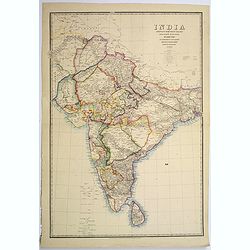
India shewing the post roads and dawk stations by James Wyld, geographer to the Queen and H.R.H. Prince Albert.
A large, decorative post road map also showing Indian railways. A color key is showing British possessions, subsidiary states, and protected and independent areas. Scale ...
Place & Date: London, ca. 1880
Selling price: $245
Sold in 2017

Tombleson's Panoramic Map of the Thames and Medway London Published by G.W.Bacon & Co Ltd 127 Strand.
Tombleson’s Panoramic Map of the Thames and Medway London Published by G.W.Bacon & Co Ltd 127 Strand.Attractive steel engraving of the rivers Thames and Medway from...
Place & Date: London, 1880
Selling price: $180
Sold in 2017
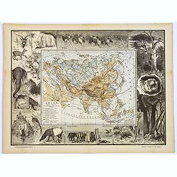
Asien.
An unusual and decorative late Victorian xylographic map of Asia, by the German publisher Otto Spamer. The map itself is surrounded by uncolored woodcut engravings of the...
Place & Date: Leipzig, ca. 1880
Selling price: $90
Sold in 2017
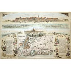
Long Beach, Long Island. 1. Long Beach Hotel. 2. Bathing Pavilion. 3. Map Showing the route to Long Beach.
3 views on one sheet. Map depicts the city map of New York and the city with its surroundings.
Place & Date: London, ca. 1880
Selling price: $235
Sold in 2018
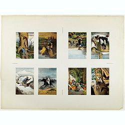
Eight chromolithographed plates on one sheet.
Lot of 8 similar sheets with chromo lithographed with on each sheet a verytale. Each verytale 130 x 90mm.
Place & Date: Germany, ca. 1880
Selling price: $140
Sold in 2018