Browse Listings
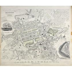
Edinburgh.
A beautiful plan of the city of Edinburgh, Scotland by the Society for the Diffusion of Useful Knowledge. Centred on the Old Town, it covers the city of Edinburgh in exce...
Place & Date: London, 1834
Selling price: $120
Sold in 2020
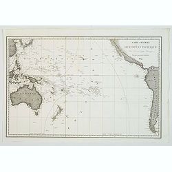
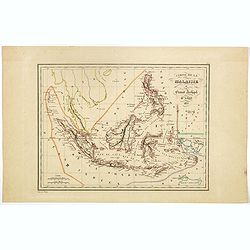
Carte générale de l'océan pacifique. . .
depicting the Pacific Ocean, with nice detail of Hawaii. With a complete outline for Australia and Tasmania. Shows the south east Asian region and South America. Jules S...
Place & Date: Paris, 1834
Selling price: $75
Sold in 2021
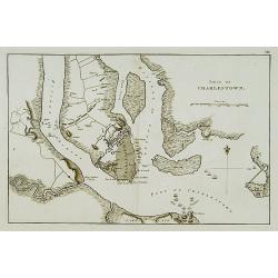
Siége de Charlestown.
Map showing vicinity around Charlestown. Showing a detailed plan of the town, roads, rivers or creeks & positions of the English troops.A french version of a map from...
Place & Date: Paris, c. 1834
Selling price: $170
Sold
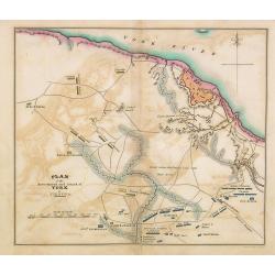
Plan of the investment and attack on York in Virginia.
Map showing vicinity around York, VA. Shows American artillery, French Hospital, roads, rivers or creeks & positions of troops. Also, note Field where the British lai...
Place & Date: Philadelphia, 1806 -1834
Selling price: $200
Sold in 2014
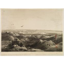
Réunion de la riviere Pierre Jaune avec le Missouri.
Original aquatint engraving after Karl Bodmer. Engraved by Salethé and printed by Bougeard.Karl Bodmer was engaged by Prince Maximilian to provide a record of his travel...
Place & Date: Paris, 1834
Selling price: $300
Sold in 2019
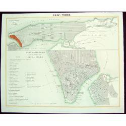
NEW-YORK
A scarce, uncommon early 19th-century French plan of New York City. The work is finely rendered and provides two different plans of the city. The upper portion consists o...
Place & Date: Paris, dated 1835
Selling price: $400
Sold in 2008
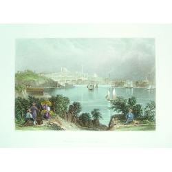
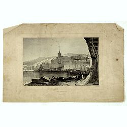
"View of Baltimore"
A small but beautiful early 19th century view of Baltimore as seen from its Inner Harbour. Many important city sites are clearly visible. A very fine steel plate engravin...
Place & Date: London, 1835
Selling price: $70
Sold
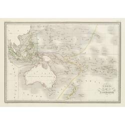
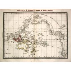
Carte de l'Océanie.
Steel engraving of Australia, New Zealand and Indonesia. Engraved by Thierry.Published by Conrad Malte-Brun (1775-1826). Mapping of Australia [+]
Place & Date: Paris, c.1835
Selling price: $100
Sold in 2023
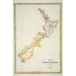
Carte de la Nouvelle-Zélande pour servir au Voyage pittoresque autour du Monde
Dumont d'Urville was second in command on Duperrey's expedition of 1824 and later led his own expedition to the Pacific aboard the 'Astrolabe'. The 'Dictionary of Mapmake...
Place & Date: Paris: L.Tenré, 1835
Selling price: $300
Sold

VUE DE L'ETABLISSEMENT DES MISSIONS À ST. JOHNS DANS L'ISLE D'ANTIGOA AUX INDES ORIENTALES
Extremely rare and important aquatint view of Antigua! Based on original works by L. Stobwasser, engraved by Franz Hegi. Illustrates a scene of island life with slaves ...
Place & Date: Basle, 1835
Selling price: $500
Sold in 2009
Coleccion de mapas Geográficos Antiguos y Modernos del Acreditado Tardieu y otros Autores Clásicos.
A Spanish atlas published by 'los redactiores del Diccionario Geographico Universal'. Folio, hlf. leath., back goldstamped (sl. chafed). With 42 double-page maps, origina...
Place & Date: Barcelona, 1835
Selling price: $2000
Sold in 2008

Tombeau d'une Bramine brulée sur le bucher de son mari.
Depiction of an Indian temple after Barthelemy Lauvergne (1805-1875) and engraved in aquatint technique by Sigismond Himely (1801-1872). Published as plate 13 in Voyage a...
Place & Date: Paris, Finot, 1835
Selling price: $100
Sold in 2014
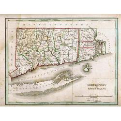
CONNECTICUT AND RHODE ISLAND
Detailed map of Connecticut and Rhode Island, with Block Island and also Long Island. The outline coloring indicates the county and state borders. Published in the popul...
Place & Date: Boston, 1835
Selling price: $50
Sold in 2011
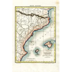
Espagne Orientale Comprenant les Provinces de Catalogne et de Valence
Attractive and unusual steel engraved map showing the eastern part of Spain with Barcelona, Valencia, and the Balearic Islands of Ibiza, Mallorca, and the tip of Menorca....
Place & Date: Paris, c1835
Selling price: $40
Sold in 2008
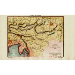
Carte de la Campagne de l'Armée D'Italie en 1809
Attractive and unusual steel engraved map illustrates the military activities in Austria, Hungary, and the Istria peninsula in 1809, during the Franco-Italian Napoleon fo...
Place & Date: Paris, c1835
Selling price: $40
Sold in 2008
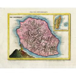
Ile Bourbon.
Very attractive and unusual steel engraved map of the island of Réunion. Large scale and thus very detailed map of the island, with many cities and places named. Particu...
Place & Date: Paris, c.1835
Selling price: $80
Sold in 2010
Carte du Sénégal / Plan de l\'Isle St. Louis / Vue du Fort St. Louis du côté de la mer. / Environs de l' Isle St. Louis.
Four maps on one sheet showing the position of the French stronghold of Fort St. Louis in Senegal.
Place & Date: Paris, ca. 1835
Selling price: $98
Sold in 2009

Vue de Gracehill dans l'Isle d'Antigoa...
Extremely rare and important aquatint view of Antigua!Based on original works by L. Stobwasser, engraved by Hürlimann.Illustrates a scene of island life at the Gracehill...
Place & Date: Basle, 1835
Selling price: $660
Sold in 2009
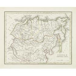
Siberia & central Asia.
This map covers the eastern section of Russia as well as China, Japan, Korea, India and Tibet. The map is of interest for the use of East Sea, the sea between Korea and J...
Place & Date: Boston, 1835
Selling price: $80
Sold in 2010
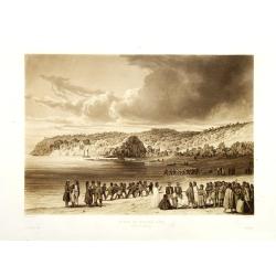
Plage de Kokora - Rêka (Nouvelle Zélande).
This plate comes from "Voyage autour du monde par les mers de l'Inde et de la Chine de la corvette de sa Majeste La Favorite execute pendant les annees 1830, 1831, 1...
Place & Date: Paris, no date 1835
Selling price: $375
Sold in 2010
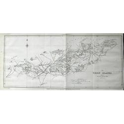
The Virgin Islands, shewing The Set of The Tide amongst them. . .
Highly important lithograph map of the Virgin Islands, published by John Murray. Extending from Green and Brigantine Islands just east of St. Thomas to Virgin Gorda in th...
Place & Date: London, 1835
Selling price: $164
Sold in 2011
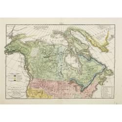
America Settentrionale..
Rare and detailed map of the northern part of the United States of America and Canada, including Alaska, engraved by Marco Zuliani. According to the title cartouche, prep...
Place & Date: Venice, 1835
Selling price: $96
Sold in 2011
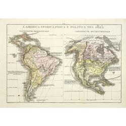
L\'America storica, fisica e politica nel 1825.
Rare and detailed map of the northern and southern part of America. According to the information on the map, prepared by Las Casas A de La Sage . From l'Atlante St.Geog.P...
Place & Date: Venice, 1835
Selling price: $181
Sold in 2011

Port Louis à l'ile de France. (Mauritius)
Aquatint by Sigismond Himely (1801-1872) after Walter Paris (fl.1849-1891) published in "Laplace, Voyage autour du monde" by Sainson. Rare view of Port Louis on...
Place & Date: Paris, 1835
Selling price: $310
Sold in 2011
Stati-Uniti Dell'America settentrionale. . .
Rare and detailed map of eastern part of the United States of America, including Great Lakes, Florida, engraved by Marco Zuliani. According to the title cartouche, prepar...
Place & Date: Venice, 1835
Selling price: $250
Sold in 2011

Marie-Louise-Charlotte-Philippine Pairie, fille soumise & patentée par la police. (Plate 452 in la Caricature).
Marie Louise Charlotte Philippine Pairie, prostitute, accredited by the police. An ugly woman, who is the daughter of Louis-Philip, is playing with gold coins. The captio...
Place & Date: Paris, La Caricature, January 1, 1835
Selling price: $400
Sold in 2017
![[Lot with two maps] Map of the Three Kingdoms / Map of the Great Ming Dynasty.](/uploads/cache/92041-250x250.jpg)
[Lot with two maps] Map of the Three Kingdoms / Map of the Great Ming Dynasty.
Two beautifully colored Japanese woodblock maps of China, one of China during the Three Kingdoms period and a second of Ming China, 1368-1644.
Place & Date: Japan, ca.1835
Selling price: $350
Sold in 2012
Carte de la Nouvelle-Zélande pour servir au Voyage pittoresque autor du Monde par M.D'Urville 1835
Map of New Zealand. Engraved by Ambroise Tardieu. Errors by Cook now updated.Dumont d'Urville was second in command on Duperrey's expedition of 1824 and later led his own...
Place & Date: Paris, L.Tenré, 1835
Selling price: $450
Sold in 2016
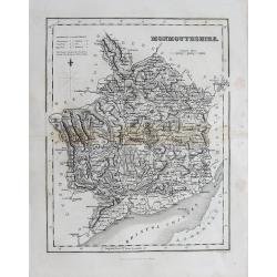
(Lot of 2 maps) Wales - Monmouthsthire
An interesting pair of old maps of Wales: - Fullarton, ca. 1835, "Monmouthshire". 240 x 190 mm. A detailed map with much information, showing also the distance...
Place & Date: England, c1835
Selling price: $1
Sold in 2012
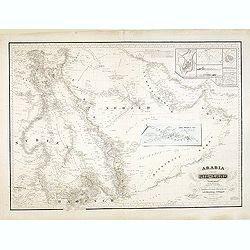
Arabia und das Nil-Land den manen Karsten Niebuhr's hochverdienten forschern. . .
Rare map of the Arabian Peninsula and the east coast of Africa with the River Nile. Inset plans include Jeddah, Mecca and Medina, and a trompe-l'oeil of the caravan route...
Place & Date: Gotha, Justus Perthes, 1835
Selling price: $1100
Sold in 2013
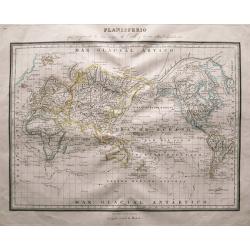
Planisferio que comprende los tres viajes de Cook y tierras ultim_te descubiertas.
Very uncommon Spanish world map centered on Australia. Illustrates the routes and dates of Captain Cooks voyages. Includes a wealth of place names, and information on d...
Place & Date: Barcelona, c1835
Selling price: $35
Sold in 2014

Pour un pauvre américain, s'il vous plait. (For a Poor American, Please)
Lithography published in the newspaper "la Caricature" N°222, plate 463, satire on the reparation asked by the American government after Napoleon's blockade, w...
Place & Date: Paris, 1835
Selling price: $375
Sold in 2017
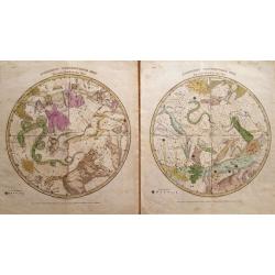
(2 charts) Northern Circumpolar Map for each Month in the Year & Southern Circumpolar Map for each Month . . .
Scarce pair of celestial charts from Elijah H. Burritt’s famous "Atlas Designed to Illustrate the Geography of the Heavens" published by F. J. Huntington &...
Place & Date: Hartford, 1835
Selling price: $150
Sold in 2014
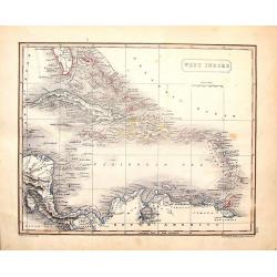
West Indies.
Fine map from Sidney Hall's 1835 "NEW GENERAL ATLAS". The map was drawn by Arrowsmith, engraved by Hall and published by Longman, Rees, Orme Brown & Green i...
Place & Date: London, 1835
Selling price: $51
Sold in 2016
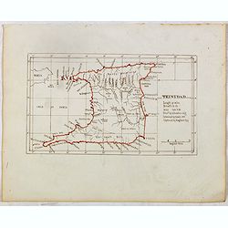
TRINIDAD . . .
Finely executed pend drawing in brown ink with coast line in red color. Scale is in English miles. Underneath the title an explanation.
Place & Date: ca. 1835
Selling price: $120
Sold in 2015
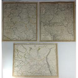
Three S.D.U.K. Maps - Russia II, Russia V & Russia VI
Three detailed maps of Russia by S.D.U.K. published in London in 1835 by Chapman & Hall. “Russia II” covers Olonetz, Iaroslav, Arkhangel, Vologda, Viarka & Pe...
Place & Date: London, 1835
Selling price: $24
Sold in 2016
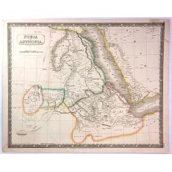
Nubia and Abyssinia
A pleasant map of Nubia and Abyssinia (Ethiopia) that covers from Darfur east to the Sea of Bab el Mandeb (Gulf of Aden) and from the Desert of Chebba south to Donga. Inc...
Place & Date: London, 1835
Selling price: $7
Sold in 2016
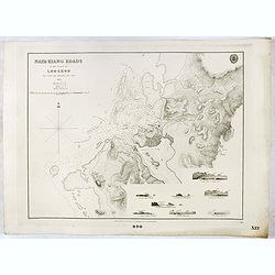
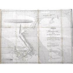
Napa-Kiang Roads in the island of Loo-Choo by Capt. F.W. Beechy RNN FRS. 1827.
Large scale chart of the present day Naha harbour at Okinawa in the Japan Sea. With several coastal profiles, scale and vignette of Hydrographical office. Map nr. 990.Pre...
Place & Date: London, 1835
Selling price: $220
Sold in 2017
Carte d'une partie de la Côte de Cochinchine (deuxième feuille)...
A scarce large-scale sea-chart of a portion of the Vietnamese coast, with the tracks of the Corvette Favorite in January and February 1831. With an exact representation o...
Place & Date: Paris, 1833-1835
Selling price: $80
Sold in 2016
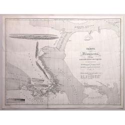
Carte des Découvertes faites dans les régions arctiques en 1829,30,31,32,33. Par John Ross...
An interesting map of an area in the Canadian arctic region 'Nunavut', with parts of Baffin Island, Somerset Island, Baffin Bay, Prince Regent Inlet, and Boothia Gulf.Inc...
Place & Date: Paris, 1835
Selling price: $45
Sold in 2016
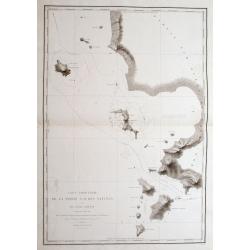
Carte Particulière De La Partie S. O. Des Natunas Et Du Canal Laplace: Découvert en Mars 1831,...
A fantastic sea-chart of a part of the Natuna Islands archipelago, which is part of the Indonesian Riau Islands Province, located in the South China Sea between Malaysia ...
Place & Date: Paris, 1833-1835
Selling price: $30
Sold in 2016
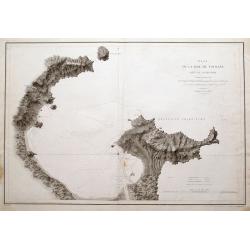
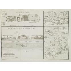
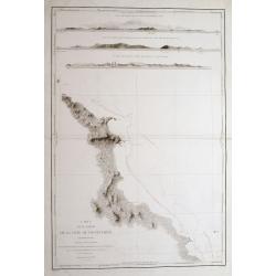
Plan de la Baie de Tourane...
An extremely detailed sea-chart of the Bay and area of Đà Nẵng or Danang in Vietnam.With numerous depth soundings, and the anchoring place of the ship...
Place & Date: Paris, 1833-1835
Selling price: $423
Sold in 2016
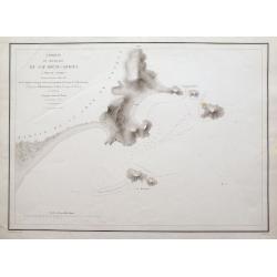
Croquis du Mouillage du Cap Boung-Quioua (Côte du Tonkin)...
A hardly obtainable sea-chart of an are in the 'Gulf of Tonkin' in northern Vietnam. It shows a bay with a village, and three smaller islands, including numerous depth so...
Place & Date: Paris, 1833-1835
Selling price: $175
Sold in 2016
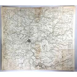
Carte Geognostique des Environs de Paris
A large detailed map from "Memoires de la Classe des Sciences Mathematiques et Physiques de l`Institut Imperial de France", by Cuvier & Brongniart, publishe...
Place & Date: Paris, 1835
Selling price: $21
Sold in 2016
Alger, vue générale prise du port.
Decorative lithography taken from "Voyage pittoresque dans la régence d'Alger" printed in 1835 by Charles Motte. Prepared by WYLD William Wyld (1806-1889) and ...
Place & Date: Paris, 1835
Selling price: $25
Sold in 2016
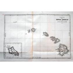
Karte der Hawaii Inseln zur malerischen Reise um die Welt 1835.
An excellent early map of Hawaii. Very good detail with many place names. An inset map shows Oahu. Probably the earliest map to use the name Hawaii to describe the entire...
Place & Date: Paris, 1835
Selling price: $105
Sold in 2016
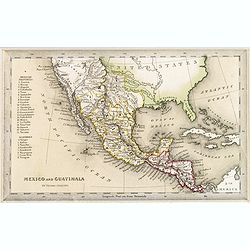
Mexico and Guatimala.
A map that has Central America split into two regions one oulined in red, the other in yellow. This is when Mexico still had possession of large swathes of California, an...
Place & Date: London, ca. 1835
Selling price: $25
Sold in 2016
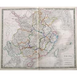
China.
A very detailed map of China and Korea, filled with place names. Includes Hainan and Taiwan, and a small inset map of Macao.
Place & Date: London, ca. 1835
Selling price: $40
Sold in 2018
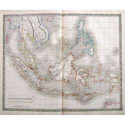
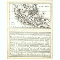
East India Islands.
An excellent map of Southeast Asia, from south Myanmar (Pegu) to a small part of northern Australia. Includes Singapore, Borneo, the Philippines, Indonesia, and a part of...
Place & Date: London, ca. 1835
Selling price: $55
Sold in 2017
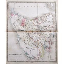
Van Diemen's Land.
A fantastic large scale map of the island with many details, including Police Districts, and names of Landholders.Issued a few years before Van Diemen's Land was granted ...
Place & Date: London, ca. 1835
Selling price: $160
Sold in 2017
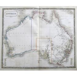
Australia.
Large map of Australia with blank interior but good detail along the coast. Shows dates of discoveries, and names the counties.
Place & Date: London, ca. 1835
Selling price: $130
Sold in 2017
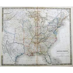
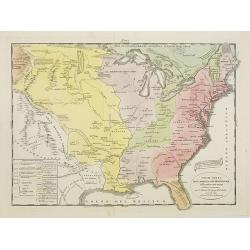
United States.
A detailed map of the United States shown until Texas and the Western Territory. Shows a large area labeled Nebraska.Includes some of the first railroads along the East C...
Place & Date: London, ca. 1835
Selling price: $120
Sold in 2017
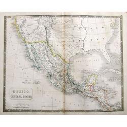
Mexico. And Central States Corrected from original information communicated by Simon A.G. Bourne Esq.
An important map of the South-West US, with Texas and Upper, or New California. With excellent detail throughout Mexico and until Costa Rica.Mines in Mexico are noted by ...
Place & Date: London, ca. 1835
Selling price: $37
Sold in 2018
Carte des Decouvertes Faites dans lesRegions Arctiques en 1829-33.
An informative and important map of the discoveries made in the Arctic Regions in 1829-33 by Sir John Ross (1777-1856) in the Hydrographic Office of the Admiralty. Engrav...
Place & Date: Paris, 1835
Selling price: $350
Sold in 2017
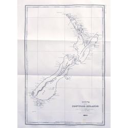
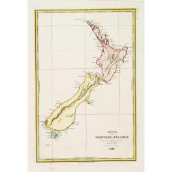
Carte de la Nouvelle-Zélande...
An early map of New Zealand after Dumont d'Urville's voyage on the Astrolabe. The larger French edition. Engraved by Tardieu.With numerous place names of bays, islands, e...
Place & Date: Paris, 1835
Selling price: $161
Sold in 2017
![Ostindien [and] Carte de L'Inde. [2 maps]](/uploads/cache/40043-250x250.jpg)
Ostindien [and] Carte de L'Inde. [2 maps]
First map is 'Ostindien' by Radefeld, from Meyer's Atlas, countries and regional boundaries shown in differing colors, with plenty of map detail, relief shown in hachures...
Place & Date: Hildeburghausen, Paris ca. 1835
Selling price: $60
Sold in 2017
Carte de la Malaisie ou Grand archipel d'Asie.
Nice map of Indonesia, Philippines, Malacca with Singapore and tip of Northern Australia. Engraved by Thierry. Countries and regions in delicate out line color. Includes ...
Place & Date: Paris, 1835
Selling price: $100
Sold in 2018
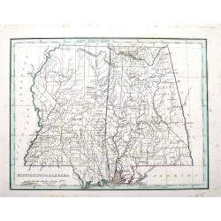
Mississippi & Alabama.
An important map by the American mapmaker Thomas Bradford. With fine detail including counties, towns, rivers, Indian nations, and the railroads of the time.
Place & Date: Boston, ca. 1835
Selling price: $15
Sold in 2018
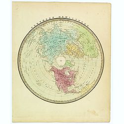
Northern Hemisphere.
A nice map of the northern hemisphere by American cartographer and map publisher, David Burr. The map is centered on the North Pole, and includes all of North America, Eu...
Place & Date: New York, ca 1835
Selling price: $35
Sold in 2023
East India Islands.
A detailed miniature map with a full-page table of place names and geographical coordinates. Shows the area from Yangon to New Guinea, including Hainan, Singapore, the Ph...
Place & Date: London, ca. 1835
Selling price: $50
Sold in 2018
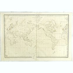
Carte Hydrographique des parties connues de la terre dressée sous la projection de Mercator par Gressier.
Very finely engraved World map in Mercator projection, prepared by C.L. Gressier, Hydrographer of the Navy, engraved by Michel and published by the Dépôt Général de l...
Place & Date: Paris, 1835
Selling price: $300
Sold in 2021
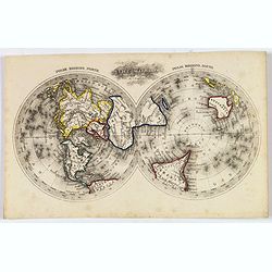
The World.
A nice miniature twin hemisphere map by Thomas Starling, from his The Royal Cabinet Atlas & Universal Compendium Of All Known Places.Maps centered on the poles. Conti...
Place & Date: London, ca. 1835
Selling price: $65
Sold in 2019
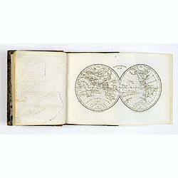
Atlas Classique Universel de Geographie ancienne et moderne. . .
>Octavo French atlas by Levasseur. Complete with 87 maps, with 9 doubles, including a Celestial map, the World in twin hemispheres, the continents etc. With title page...
Place & Date: Paris, ca 1835
Selling price: $75
Sold in 2019
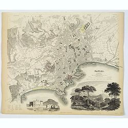
Naples.
An attractive town plan of Naples, a pair of handsome decorative vignette views of 'Naples from the Hill of Posilipo' and the 'New Castle and Castle St. Elmo'. Plan is ve...
Place & Date: London, 1835
Selling price: $95
Sold in 2019
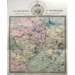
A new & improved map of the environs of Windsor, extending from 14 to 18 miles round the castle.
An apparently very scarce map (Copac with only 2 listings) of the area around Windsor. The map includes roads and distances. The title with a decorative vignette. Drawn ...
Place & Date: London, ca. 1835
Selling price: $210
Sold in 2023

Alger, Café Maure rue du Soudan.
Decorative lithography taken from "Voyage pittoresque dans la régence d'Alger" printed in 1835 by Charles Motte. Prepared by WYLD William Wyld (1806-1889) and ...
Place & Date: Paris, 1835
Selling price: $25
Sold in 2021

Alger, Petite mosquée à Oran.
Decorative lithography taken from "Voyage pittoresque dans la régence d'Alger" printed in 1835 by Charles Motte. Prepared by WYLD William Wyld (1806-1889) and ...
Place & Date: Paris, 1835
Selling price: $25
Sold in 2021
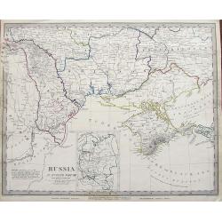
Russia in Europe Part VIII.
An early example of this interesting large scale map. Shows a part of the Black Sea with the Crimea, the Danube Delta, parts of Romania, Moldova, and the Ukraine. Include...
Place & Date: London, 1835
Selling price: $8
Sold in 2019
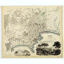
Naples.
An attractive town plan of Naples, a pair of handsome decorative vignette views of 'Naples from the Hill of Posilipo' and the 'New Castle and Castle St. Elmo'. Plan is ve...
Place & Date: London, 1835
Selling price: $35
Sold in 2019
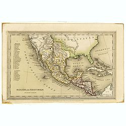
Mexico and Guatimala. By Thomas Starling.
A map that has Central America split into two regions; one outlined in red, the other in yellow. This is when Mexico still had possession of large swathes of California, ...
Place & Date: London, ca. 1835
Selling price: $45
Sold in 2019
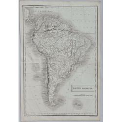
South America.
A detailed map of South America from Sidney Hall's extremely scarce 1835 “New General Atlas”. Adam & Charles Black were among the leading publishers of atlases an...
Place & Date: London, 1835
Selling price: $70
Sold in 2022
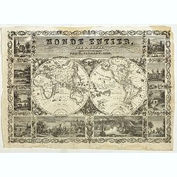
Monde Entier, Par J. Henry Dressine et Ecrit Chez L' Auteur Par A. Clement.
Decorative uncommon 19th century double hemisphere map of the word with ten vignettes surrounding the map. The vignettes show a naval battle, and a land battle with a com...
Place & Date: Paris, 1835
Selling price: $200
Sold in 2019
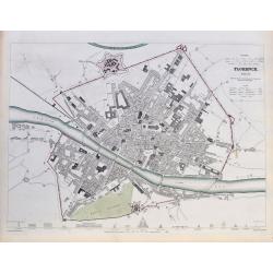
Florence. Firenze.
A highly detailed town plan of Florence, with profile views of 16 principal buildings. With street names, buildings, piazzas, the castello, etc.Drawn by W. B. Clarke, eng...
Place & Date: London, 1835
Selling price: $38
Sold in 2020
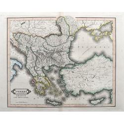
Turkey in Europe, Greece & the Ionian Islands.
A scarce and a highly detailed map of Turkey and Greece. Includes the Balkans, Cyprus, Crimea and the Black Sea. An attractive example.
Place & Date: Edinburgh, ca 1835
Selling price: $35
Sold in 2020
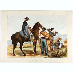
Rancheros.
The famous group of rancheros in local dress with one rider and three other men at left. From the rare and famous "Voyage pittoresque et archéologique dans la parti...
Place & Date: Paris, M. Moench, Cité Bergère, 1836
Selling price: $350
Sold in 2020
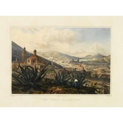
Vista General De Zacatecas.
View of Zacatecas, foreground with three giant magueys and a man harvesting.From the rare and famous "Voyage pittoresque et archéologique dans la partie la plus int...
Place & Date: Paris, 1836
Selling price: $475
Sold in 2014

Vista de Jalapa.
View of Jalapa from a distance, foreground with Native trudging up a hill, figures in middle ground.From the rare and famous "Voyage pittoresque et archéologique da...
Place & Date: Paris, 1836
Selling price: $425
Sold in 2014
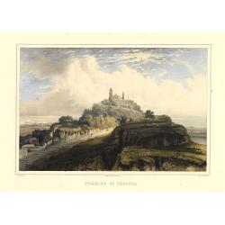
Pirámide De Cholula.
Ethereal landscape with road leading up to Cholula in the distance. Light foxing in margins, otherwise fine. From the rare and famous "Voyage pittoresque et archéol...
Place & Date: Paris, 1836
Selling price: $750
Sold in 2014

Interior de México.
Plaza of Mexico with cathedral at left, coaches, riders, muleteer with team kicking up dust, carriers and pedestrians, mountains in background. Very fine. From the rare a...
Place & Date: Paris, 1836
Selling price: $1050
Sold in 2014

Plaza Mayor De Guadalajara.
Main Plaza of Guadalajara with prominent fountain and people milling about. Very fine. From the rare and famous "Voyage pittoresque et archéologique dans la partie ...
Place & Date: Paris, 1836
Selling price: $550
Sold in 2016