Browse Listings
![[LXXX. Divinità suprema].](/uploads/cache/35015-250x250.jpg)
[LXXX. Divinità suprema].
Aquatint depicting Chinese supreme divinity, engraved by G. Zancon. Plate N°80.From Giulio Ferrario's work Le Costume Ancien et Moderne ou Histoire du gouvernement, de l...
Place & Date: Milan, 1827
Selling price: $25
Sold in 2018
![[VIII. Animali e Vegetabilidella Cina].](/uploads/cache/35017-250x250.jpg)
[VIII. Animali e Vegetabilidella Cina].
Aquatint depicting Chinese, animals and plants, engraved by G. Zancon. Plate N°8.From Giulio Ferrario's work Le Costume Ancien et Moderne ou Histoire du gouvernement, de...
Place & Date: Milan, 1827
Selling price: $25
Sold in 2018
![[LXXXII. Predicatore Giaponese].](/uploads/cache/35018-250x250.jpg)
[LXXXII. Predicatore Giaponese].
Aquatint depicting a Japanese preacher and his audience, engraved by A. Rancoti, Plate N°82.From Giulio Ferrario's work Le Costume Ancien et Moderne ou Histoire du gouve...
Place & Date: Milan, 1827
Selling price: $20
Sold in 2020
![[XXXIX. Varj sepolcri ].](/uploads/cache/35019-250x250.jpg)
[XXXIX. Varj sepolcri ].
Aquatint depicting Chinese tombs, engraved by L. Rossi. Plate N°39.From Giulio Ferrario's work Le Costume Ancien et Moderne ou Histoire du gouvernement, de la milice, de...
Place & Date: Milan, 1827
Selling price: $25
Sold in 2018
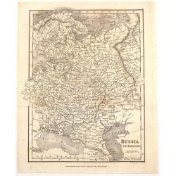
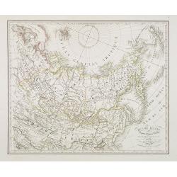
![[67 sheets - The Russian Empire in EUROPE & ASIA ]](/uploads/cache/35290-250x250.jpg)
[67 sheets - The Russian Empire in EUROPE & ASIA ]
A set of 67 maps covering the Russian Empire at time of publication. From his famous Atlas Universel . This atlas was one of the most remarkable world atlases ever produc...
Place & Date: Brussels, 1825-1827
Selling price: $4000
Sold in 2014
Mawman's Russia in Europe.
Fine little map of "Russia in Europe" published by J. Mawman & the Other Proprietors" in London in 1827. It was engraved by J. Neele.
Place & Date: London, 1827
Selling price: $26
Sold in 2015
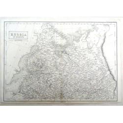
Russia in Europe, Northern Part.
Detailed map of Northern Russia in Europe by Sidney Hall in 1827, published in London. It includes "Russian Lapland".
Place & Date: London, 1827
Selling price: $16
Sold in 2016
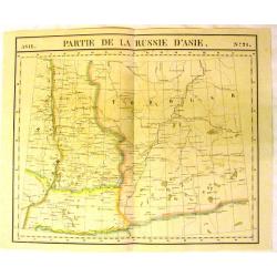
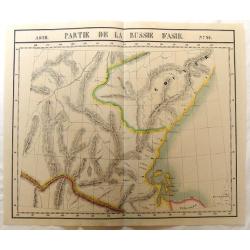
Asie, Partie de la Russie d'Asie, No.21.
Fine, large map of Russia by Philippe Vandermaelen (1795-18690, the well known Belgian geographer. It is from the Universal Atlas published in 1827.Featured is "PART...
Place & Date: Brussels, 1827
Selling price: $75
Sold in 2015
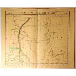
Asie, Partie de la Russie d'Asie, No.17.
Fine, large map of Russia by Philippe Vandermaelen (1795-18690, the well known Belgian geographer. It is from the Universal Atlas published in 1827.Featured is "PART...
Place & Date: Brussels, 1827
Selling price: $75
Sold in 2015
Asie, Partie de la Russie d'Asie, No.26.
Fine, large map of Russia by Philippe Vandermaelen (1795-18690, the well known Belgian geographer. It is from the Universal Atlas published in 1827.Featured is "PART...
Place & Date: Brussels, 1827
Selling price: $75
Sold in 2015
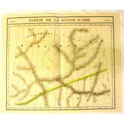
Partie de la Russie d'Asie, No. 12
From Vandemaelen’s “Atlas Universel”. This monumental work was the first atlas of the world with all maps on the same scale (about one inch to 26 miles), and the fi...
Place & Date: Brusselles, 1827
Selling price: $21
Sold in 2015
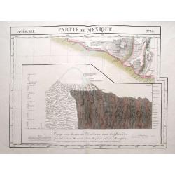
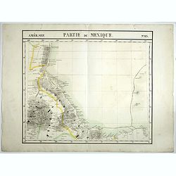
Partie du Mexique. No 70.
Detailed and important map of a part of Mexico around Chilapa and Acapulco. Below with an image of the Chimborazo vulcano when Humboldt failed to reach its peek in 1802. ...
Place & Date: Brussels, 1825-1827
Selling price: $75
Sold in 2016
![[TEXAS] Set of 5 maps in plano format, on an uniform scale, covering Texas.](/uploads/cache/35573-250x250.jpg)
[TEXAS] Set of 5 maps in plano format, on an uniform scale, covering Texas.
A set of 5 plano sheet maps covering Texas, from Vandermaelen's famous Atlas Universel.It is to be noted that only a handful of these were made in plano format (they were...
Place & Date: Brussels, 1825-1827
Selling price: $1500
Sold in 2021
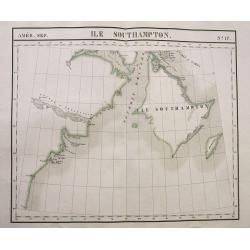
Ile Southampton.
Large scale map of Southampton Island and the Hudson Bay coastline of what is now the Kivalliq Region of southern Nunavut in Canada.Scarce and sought-after map from the f...
Place & Date: Brussels, 1827
Selling price: $50
Sold in 2016
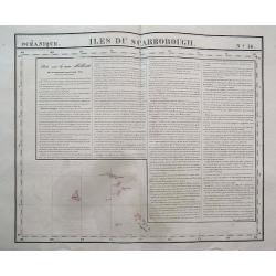
Iles Du Scarborough.
Interesting map showing Cook Island, Iles Simpson, and several others. With lengthy text about New Holland! Scarce and sought-after map from the first lithographic atlas...
Place & Date: Brussels, 1827
Selling price: $50
Sold in 2016
![[Person, 6 masks and spears]](/uploads/cache/37457-250x250.jpg)
[Person, 6 masks and spears]
Nice print showing a person, 6 masks and spears.From Giulio Ferrario's work Le Costume Ancien et Moderne ou Histoire du gouvernement, de la milice, de la religion, des ar...
Place & Date: Milan, 1827
Selling price: $25
Sold in 2016
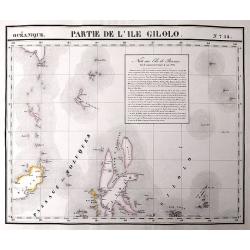
Partie de L'Ile Gilolo.
An important map of the area between Sulawesi, Mindanao, and Gilolo. Gilolo is today known as Halmahera, part of the Moluccas. The map also shows the important city of Te...
Place & Date: Brussels, 1827
Selling price: $80
Sold in 2017
![[Ritratti d'Imperatori e d'uomoni celebri].](/uploads/cache/35004-250x250.jpg)
[Ritratti d'Imperatori e d'uomoni celebri].
Aquatint depicting famous Emperors and men wearing typical Chinese dresses, engraved by L Bigatti. Plate N°11.From Giulio Ferrario's work Le Costume Ancien et Moderne ou...
Place & Date: Milan, 1827
Selling price: $20
Sold in 2018
Atlas pour servir à l'histoire Ancienne, romaine et du bas-empire des œuvres de M.r le Comte de Segur de l'Academie française, dirigé dessiné et gravé par P.Tardieu. Avec texte explicatif.
A nice example of the atlas of the works on European history from Roman times to the Middle Ages compiled by the well-known French diplomat and historian who had a turbul...
Place & Date: Paris, Alexis Eymery, 1827
Selling price: $230
Sold in 2018
Atlas encyclopédique de la géographie Physique.
Atlas volume of Atlas encyclopédique contenant les cartes et les planches relatives a la géographie physique. Edited by M.Desmarest and Bory de Sr-Vincent. 117 Pages wi...
Place & Date: Paris, 1827
Selling price: $800
Sold in 2017
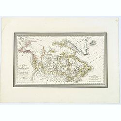
Carte de la partie Septentrionale du Nouveau Monde, ou sont Comprises Les Possessions Anglaises de l'Amerique du Nord. . .
A lovely map of Canada, and 'Amerique Russe'. Countries in outline color, four mileage scales, relief shown by hachures. Good detail of north-west coast of America.With b...
Place & Date: Paris, 1827
Selling price: $95
Sold in 2018
Partie de la Nouvelle Bretagne No. 26
A large map of Canada with the region bounded by Hudson Bay in the east and extending to Lac des Rennes and Lac du Bourleau, centered on the Fl. Bourbon ou R. Nelson, and...
Place & Date: Brusselles, 1827
Selling price: $18
Sold in 2023
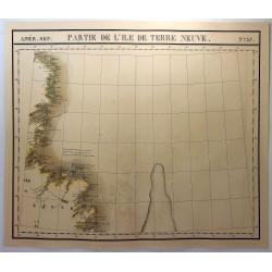
Partie de L'Ile de Terre Neuve. No. 37
A large map of the western side of Newfoundland, extending from Random Head and Flamborough Head to Wolf Island and Table Bay and centered on White Baie and Belle Isle. H...
Place & Date: Brusselles, 1827
Selling price: $27
Sold in 2018
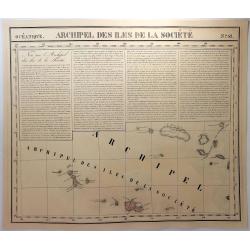
Archipel des Iles de la Societe. No. 42.
A map of the Society Islands, with a text block dealing with the area. The Society Islands includes a group of islands in the South Pacific Ocean. It is, politically and ...
Place & Date: Brusselles, 1827
Selling price: $17
Sold in 2019
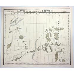
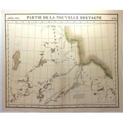
Partie de la Nouvelle Bretagne. No.16.
A hand colored, lithographed, large format map of the region of the 'Esquimaux' and 'Chippeway' lands of Canada. The map provides good topographic details. From Vandermae...
Place & Date: Brusselles, 1827
Selling price: $20
Sold in 2018
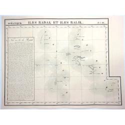
Iles Radak et Iles Ralik. No.16.
A hand colored, lithographed, large format map of Ralik and Radak, individual islands of the Marshall Islands. The map provides good topographic details and is included i...
Place & Date: Brusselles, 1827
Selling price: $13
Sold in 2021
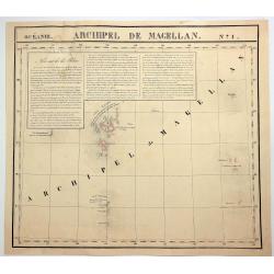
Archipel de Magellan. No. 1
A hand colored, lithographed, large format map of the Bonin and Volcano islands near Japan. The map provides good topographic details. From Vandermaelen's remarkable 6 vo...
Place & Date: Brusselles, 1827
Selling price: $37
Sold in 2018
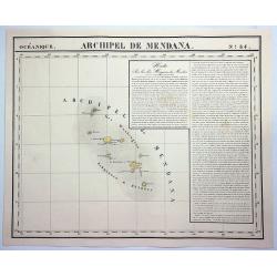
Archipel de Medana. No. 34.
A hand-colored, lithographed, large format map of the Archipel de Medana (Iles Washington) between Viet Nam and the Philippines. The map provides good topographic details...
Place & Date: Brusselles, 1827
Selling price: $11
Sold in 2020
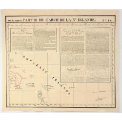
Partie de L'Arch. De la Nlle. Irlande. No. 25
A hand colored, lithographed map covers part of the islands around New Ireland, island of the Bismarck Archipelago, near Papua New Guinea in southwestern Pacific Ocean. T...
Place & Date: Brusselles, 1827
Selling price: $10
Sold in 2019

Carte d'Asie dresse´e par G. Delisle et Phil. Buache . . .
Map of Asia. Relief shown pictorially. Small inset map of Siberia in the upper left corner. Good detail in the Philippines.The map is of interest for the use for the dual...
Place & Date: Paris, 1827
Selling price: $450
Sold in 2018
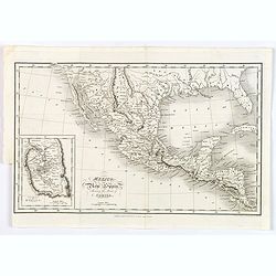
Mexico, or New Spain, Shewing the Route of Cortes.
This map gives good detail of towns, rivers and mountain ranges in southern United States through Costa Rica, and extends to include Cuba. Texas is identified as the New ...
Place & Date: London, 1827
Selling price: $85
Sold in 2018
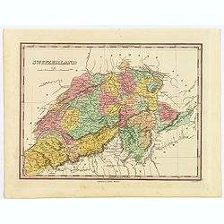
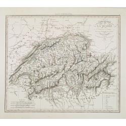
Switzerland.
A beautiful example of Finley's 1827 map of Switzerland. With Finley's classic minimalist style, this map identifies cities, forests, river systems, swamps and mountains....
Place & Date: Philadelphia, 1827
Selling price: $10
Sold in 2019
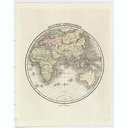
Eastern Hemisphere.
A nice example of Finley's 1827 map of the Eastern Hemisphere. It is seen with all of Finley's classic minimalist style, this map identifies some cities, river systems an...
Place & Date: Philadelphia, 1827
Selling price: $38
Sold in 2019
Partie du Mexique. No 65.
PLANO sheet map covering Mexico. From his famous Atlas Universel . This atlas was one of the most remarkable world atlases ever produced, anticipating the International M...
Place & Date: Brussels, 1825-1827
Selling price: $80
Sold in 2021
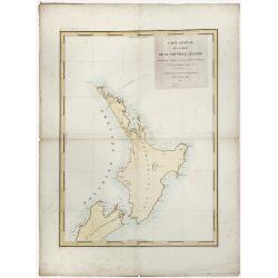
Nouvelle Zelande.
Detailed chart of the North Island of New Zealand, Cook Straits and part of the south Island, based upon the observations of the French expedition led by Dumont D'Urville...
Place & Date: Paris, 1827
Selling price: $205
Sold in 2019
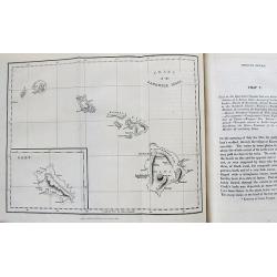
A Narrative of a tour through Hawaii. . .
Excellent and famous report of Hawaii in 1822 and 1823. With the two sought-after maps of Hawaii and the Sandwich Isles in excellent condition! Further with engraved fron...
Place & Date: London, 1828
Selling price: $700
Sold in 2012
A Map of North America, Constructed According To The Latest Information ... Improved to 1828.
It says in the title : "improved to 1828". This milestone map was first issued issued separately in 1822 and also bound in four sheets into Tanner's "New ...
Place & Date: Philadelphia, Henry Tanner, after 1828
Selling price: $7800
Sold in 2013
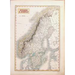
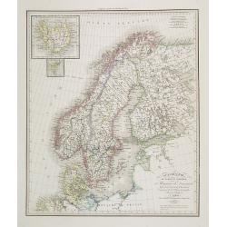
Sweden & Norway.
A striking hand-colored engraving featuring Sweden & Norway. It was engraved by Syd Hall and published in "A NEW GENERAL ATLAS" by Longman, Rees, Brown &...
Place & Date: London, 1828
Selling price: $16
Sold in 2018
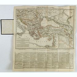
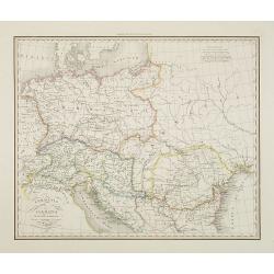
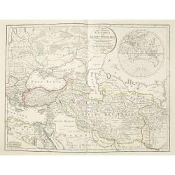
Carte du théatre de la guerre, comprenant la Turquie d'Europe et d'Asie, la Grèce entière et pays limitrophes, avec les routes. . .
Rare map of the Black Sea are, with the Caucasus, Turkey, Greece and Ukraine. Printed from two copper plates. Lower part containing "Suite de la description des prov...
Place & Date: Paris, H. Langlois, fils, 1828
Selling price: $280
Sold in 2020
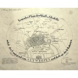
Neuester Plan der Stadt und Citadelle nebst der Umgegend von ANTWERPEN und der Lage der fr. Batterien.
Curious and apparently rare plan of Antwerp and surroundings, published in "Hennig's Bilderschätze". With two keys 1-15 and 1-6 identifying buildings and forti...
Place & Date: Prague, ca. 1828
Selling price: $93
Sold in 2015
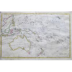
Oceanica 1828.
An uncommon Italian map of South-East Asia, Australia, New Zealand, Hawaii, and the southern Pacific. It shows and names many islands and places along the coasts. Also sh...
Place & Date: ca. 1828
Selling price: $42
Sold in 2017
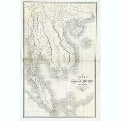
Map of the Kingdoms of Siam and Cochin China compiled by John Walker. . .
A large map (925 x 607mm)covering south western China, Cambodia, Laos, Tonquin, Cochin China (Vietnam), Siam (Thailand), Malaysia, and parts of Sumatra and Borneo. Map is...
Place & Date: London, 1828
Selling price: $550
Sold in 2018
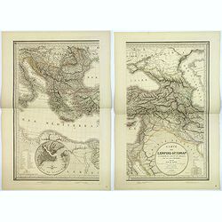
Carte de l'Empire Ottoman en Europe, en Asie et en Afrique, avec les pays limitrophes.
A large map on the Ottoman Empire, engraved and published by J. Alexis Orgiazzi, engraver for the Dépôt Général de la Guerre. It stretches from north to south between...
Place & Date: Paris, 1828
Selling price: $110
Sold in 2018
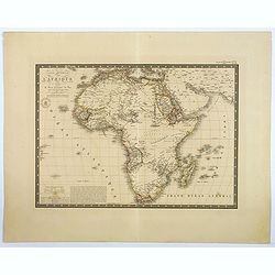
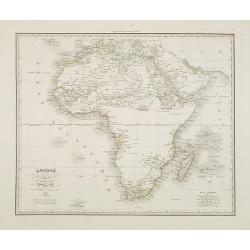
Carte Generale de L'Afrique.
This interesting map of the continent extends to include the Arabian Peninsula, Persia, and the islands in the Indian Ocean. There is a fair degree of geographical detail...
Place & Date: Paris, 1828
Selling price: $120
Sold in 2018
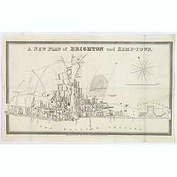
A new plan of Brighton and Kemp-Town.
An attractive and scarce town plan of Brighton and Kemp Town towards the end of the reign of George IV in 1828. You see development all along Kings Road and Marine Parade...
Place & Date: London, 1828
Selling price: $275
Sold in 2020
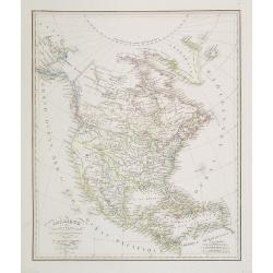
Amerique Septentrionale.
A fine map of North America published by the well-known Paris publisher of maps, globes and atlases C.F. Delamarche.C.F. Delamarche (1740-1817) was a French geographer an...
Place & Date: Paris, 1828
Selling price: $130
Sold in 2019
Turquie D'Europe.
A fine map of Turkey in Europe, from the “Atlas de la Géographie Ancienne du Moyen Age, et Moderne" by Delamarche in 1833 in Paris.Félix Delamarche was a French ...
Place & Date: Paris, 1828
Selling price: $23
Sold in 2020
Amérique septentrionale..
General map of north America.
Place & Date: Paris 1828
Selling price: $22
Sold
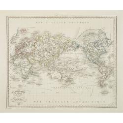
Mappemonde projetée sur l'horizon de Paris.. / Mappemonde sur la projection polaire.
Large sheet with two maps. The first is a map of the world in two hemispheres, with the poles being fully visible, while the second set has poles at center. Arctic region...
Place & Date: Paris 1828
Selling price: $240
Sold
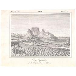
Die Capstadt..
Left top numbered Zu pag. 125. date in middle top, and right top numbered Tab. XXV. Uncommon German view of Table Bay and Cape Town ca. 1828. The print interestingly is s...
Place & Date: 1828
Selling price: $50
Sold
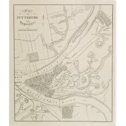
Plan von Pittsburg und umgebungen.
An detailed and rare view of Pittsburgh with a title in German, but details on map in English. From Bernhard zu Sachsen-Weimar-Eisenach: Reise durch Nord-Amerika.
Place & Date: Weimar, 1828
Selling price: $200
Sold
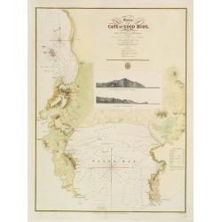
Survey of the Cape of Good Hope.
Large scale chart of the Cape of Good Hope. Engraved by J. & C.Walker. The survey was made by Lieut. A.T.E. Vidal of H.M.S. Leven assisted by Capt. Charles Lechmere, ...
Place & Date: London 1828
Selling price: $1650
Sold

La vue du bassin de Norton sur le cours de la rivière Nepean (Nouvelle Galles méridionale).
Uncommon lithography by Langlumé showing River Nepean. From ALBUM PITTORESQUE DELA FRÉGATTE LA THÉTIS ET DE L''ESPÉRANCE. Collection de dessins relatifs à autour du ...
Place & Date: Paris, 1828
Selling price: $100
Sold in 2008
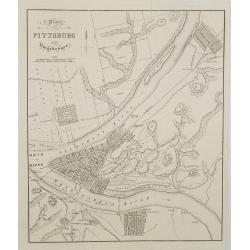
Plan von Pittsburg und umgebungen.
An detailed and rare view of Pittsburgh with a title in German, but details on map in English. From Bernhard zu Sachsen-Weimar-Eisenach: Reise durch Nord-Amerika.
Place & Date: Weimar, 1828
Selling price: $400
Sold in 2008
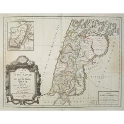
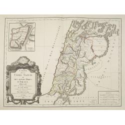
Carte de la Terre Sainte ou des Douze Tribus d'Israel Dressée D'Après les Ouvrages Géographiques De Guil. Delisle. Et d'après les Auteurs et Voyageurs anciens et modernes Par Dezauche, Géographe et successeur de Guil. Delisle et Phil. Buache.
Well-engraved and attractive map of Palestine "divided among the Tribes on both sides of the Jordan and according to the Roman provinces. The shore line runs form Be...
Place & Date: Paris, 1828
Selling price: $200
Sold in 2014
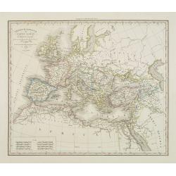
Imperium Romanum ou Empire Romain . . .
Detailed map of the ancient Roman Empire covering southern Europe, North Africa and part of Asia, prepared by A. H. Basset, rue Saint-Jacques, no. 64, Paris and published...
Place & Date: Paris, A.H. Basset, 1828
Selling price: $50
Sold in 2009
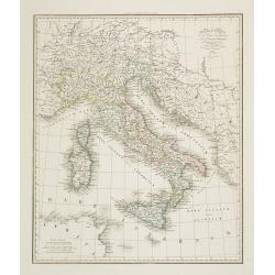
Italia Antiqua . . .
Detailed map of Ancient Italy, including Sardinia and Corsica, published by A. H. Basset, rue Saint-Jacques, no. 64, Paris and published in Atlas classique et Universel d...
Place & Date: Paris, A.H. Basset, 1828
Selling price: $45
Sold in 2023
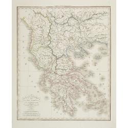
Grecia Antiqua . . .
Detailed map of Ancient Greece, prepared by A. H. Basset, rue Saint-Jacques, no. 64, Paris and published in Atlas classique et Universel de Géographie . . . .The engrave...
Place & Date: Paris, A.H. Basset, 1828
Selling price: $13
Sold in 2022
Germania pannonia d'Acia et Sarmatia ad Juventutis Institutionem . . .
Map of Ancient central Europe, prepared by A. H. Basset, rue Saint-Jacques, no. 64, Paris and published in Atlas classique et Universel de Géographie . . . .The engraver...
Place & Date: Paris, A.H. Basset, 1828
Selling price: $20
Sold in 2009
Géographie du Moyen-Age et plus particulierement des IX et X. siecles . . .
World map during Medieval times, prepared by Harisson and published by A. H. Basset, rue Saint-Jacques, no. 64, Paris and published in Atlas classique et Universel de Gé...
Place & Date: Paris, A.H. Basset, 1828
Selling price: $80
Sold in 2013
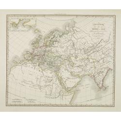
Planisphère comprenant les nouvelles découvertes et les trois voyages de Cook . . .
Detailed world map in Mercator projection of the 3 voyages and discoveries of Captain Cook, prepared by Harisson and published by A. H. Basset, rue Saint-Jacques, no. 64,...
Place & Date: Paris, A.H. Basset, 1828
Selling price: $240
Sold
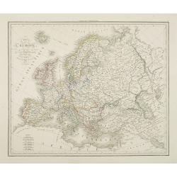
Carte de l'Europe . . .
Detailed map of Europe, prepared by A. H. Basset, rue Saint-Jacques, no. 64, Paris and published in Atlas classique et Universel de Géographie . . . .The engraver of the...
Place & Date: Paris, A.H. Basset, 1828
Selling price: $85
Sold in 2009
Italie et Royaume d'Illyrie . . .
Detailed map of Italy, prepared by A. H. Basset, rue Saint-Jacques, no. 64, Paris and published in Atlas classique et Universel de Géographie . . . .The engraver of the ...
Place & Date: Paris, A.H. Basset, 1828
Selling price: $20
Sold in 2023
Carte routière de la Suisse . . .
Road map of Switzerland, prepared by A. H. Basset, rue Saint-Jacques, no. 64, Paris and published in Atlas classique et Universel de Géographie . . . .The engraver of th...
Place & Date: Paris, A.H. Basset, 1828
Selling price: $100
Sold
Scandinavie ou Suède et Norwège et Royaume de Danemark . . .
Detailed map of Sweden, Norway, Finland and Denmark, prepared by A. H. Basset, rue Saint-Jacques, no. 64, Paris and published in Atlas classique et Universel de Géograph...
Place & Date: Paris, A.H. Basset, 1828
Selling price: $100
Sold in 2010
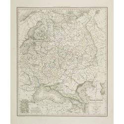
Russie d'Europe . . .
Detailed map of the European part of Russia, including the Black Sea region, prepared by A. H. Basset, rue Saint-Jacques, no. 64, Paris and published in Atlas classique e...
Place & Date: Paris, A.H. Basset, 1828
Selling price: $150
Sold in 2009
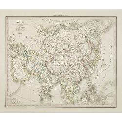
Asie . . .
Detailed map of Asia, prepared by A. H. Basset, rue Saint-Jacques, no. 64, Paris and published in Atlas classique et Universel de Géographie . . . .The engraver of the m...
Place & Date: Paris, A.H. Basset, 1828
Selling price: $135
Sold in 2024
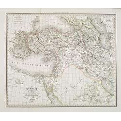
Turquie d'Asie . . .
Detailed map of Turkey, Armenia, Cyprus, part of Arabia and Israel and Syria, prepared by A. H. Basset, rue Saint-Jacques, no. 64, Paris and published in Atlas classique ...
Place & Date: Paris, A.H. Basset, 1828
Selling price: $100
Sold
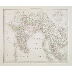
Inde en-deça et au-dela du Gange. . .
Detailed map of India and the Malayan Peninsula, prepared by A. H. Basset, rue Saint-Jacques, no. 64, Paris and published in Atlas classique et Universel de Géographie ....
Place & Date: Paris, A.H. Basset, 1828
Selling price: $100
Sold in 2015
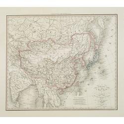
Empire Chinois . . .
Detailed map of Chinese Empire, including Japan, Taiwan, prepared by A. H. Basset, rue Saint-Jacques, no. 64, Paris and published in Atlas classique et Universel de Géog...
Place & Date: Paris, A.H. Basset, 1828
Selling price: $300
Sold
Russie d'Asie. . .
Detailed map of Siberia, China and part of Alaska, prepared by A. H. Basset, rue Saint-Jacques, no. 64, Paris and published in Atlas classique et Universel de Géographie...
Place & Date: Paris, A.H. Basset, 1828
Selling price: $200
Sold in 2010
Afrique . . .
Detailed map of Africa, prepared by A. H. Basset, rue Saint-Jacques, no. 64, Paris and published in Atlas classique et Universel de Géographie . . . .The engraver of the...
Place & Date: Paris, A.H. Basset, 1828
Selling price: $160
Sold in 2009

Egypte . . .
Detailed map of Egypt, prepared by A. H. Basset, rue Saint-Jacques, no. 64, Paris and published in Atlas classique et Universel de Géographie . . . .The engraver of the ...
Place & Date: Paris, A.H. Basset, 1828
Selling price: $150
Sold in 2011
Amérique Septentrionale . . .
Detailed map of North America, prepared by A. H. Basset, rue Saint-Jacques, no. 64, Paris and published in Atlas classique et Universel de Géographie . . . .The engraver...
Place & Date: Paris, A.H. Basset, 1828
Selling price: $70
Sold in 2022
Carte de La Terre Sainte ou des douze tribus d'Israel.
Fine map of Palestine divided among the tribes on both sides of the Jordan and according to the Roman provinces. The shore line runs from Beirut to the rivers of Egypt. W...
Place & Date: Paris, 1828
Selling price: $300
Sold in 2010
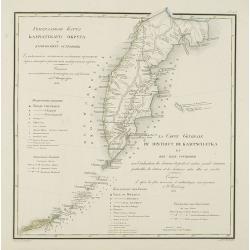
La carte générale du district de Kamtschatka et des isles Courilsks. . .
Very rare map of Kamtschatka with title in Russian and French from the atlas by Vasilii Petrovich PIADYSHEV [PIADISCHEFF] (1769-1836 Functionary of the 6th Rank.) : Geogr...
Place & Date: St.Petersburg, Topographic Depot, 1828
Selling price: $800
Sold in 2010
Carte des Anciens Empires et Grandes Monarchies pour l'Intelligence des Histoires ancienne et Romaine, de Rollin et autres auteurs. . .
Detailed copper-engraved map of the Near East, including Turkey, Cyprus, Iran, Irak, the Black and Caspian Sea. With a inset of the Eastern hemisphere, with a diameter of...
Place & Date: Paris, 1828
Selling price: $300
Sold in 2012
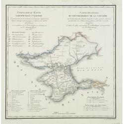
Carte générale du gouvernement de la Tauride. . .
Very rare map of Crimea with title in Russian and French from the atlas by Vasilii Petrovich PIADYSHEV [PIADISCHEFF] (1769-1836 Functionary of the 6th Rank.) : Geografice...
Place & Date: St.Petersburg, Topographic Depot, 1828
Selling price: $750
Sold in 2010
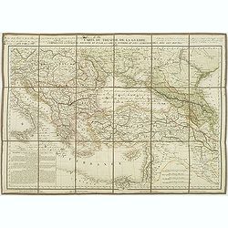
Carte du théatre de la guerre comprenant la Turquie d'Europe et d'asie. . .
Map of Turkey, Greece, east of Europe, Cyprus, Palestine, and Crime with the Black Sea region. Detailed map in the lower left corner a description of principal cities of ...
Place & Date: Paris, 1828
Selling price: $285
Sold in 2011
Carte de la turquie d'Europe et d'Asie. . .
Interesting map of the region of the Black Sea, published in the year at the outbreak of The Russo–Turkish War (1828–1829). The war broke out after the Sultan, incens...
Place & Date: Paris, 1828
Selling price: $200
Sold in 2011