Browse Listings
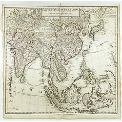
Carte des Indes et de la Chine . . .
Scarce state of "Carte des Indes et de la Chine. A Paris Chez l’Auteur, Rue des Canettes prez de St. Sulpice. Avec Privilège pour 20 ans, 1705. This early state w...
Place & Date: Paris, 1705
Selling price: $500
Sold in 2018
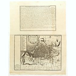
![Sixieme plan de la ville de Paris, et ses accroissements depuis le régne de Charles VII. l'an 1422. jusqu'a la fin du régne de Henry III, l'an 1589 [...] par M.L.C.D.L.M.](/uploads/cache/42344-250x250.jpg)
Sixieme plan de la ville de Paris, et ses accroissements depuis le régne de Charles VII. l'an 1422. jusqu'a la fin du régne de Henry III, l'an 1589 [...] par M.L.C.D.L.M.
Sixth map of the city of Paris, and its additions, from the beginning of the reign of Charles VII in the year 1422 to the end of the reign of Henry III in the year 1589&q...
Place & Date: Paris, 1705
Selling price: $450
Sold
Marseille ville considerable de Provence fameux port sur la mer de Mediterranée par N. De Fer.
Map centered on Marseille with nice detail of it surroundings, from Nicolas de Fer's "L'Atlas curieux ou le Monde réprésente dans des cartes. "The "Atlas...
Place & Date: Paris, 1705
Selling price: $18
Sold in 2019
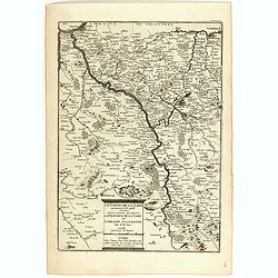
Le cours de la Sare aux environs de la quellese trouve diverses provinces qui composent la province de la Sare ou Lorraine Allemande.
Map of the Lorraine region with a part of west Germany, from Nicolas de Fer's "L'Atlas curieux ou le Monde réprésente dans des cartes. "The "Atlas Curieu...
Place & Date: Paris, 1705
Selling price: $40
Sold in 2020
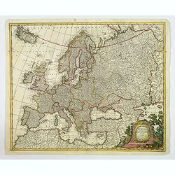
Europa Pars tenet Haec Mundi. . .
A nice, attractive map of the continent of Europe by G & L Valk of Amsterdam. The differing regions are colored in outline. Good map detail shown, and set off by a wo...
Place & Date: Amsterdam, ca 1705
Selling price: $120
Sold in 2023
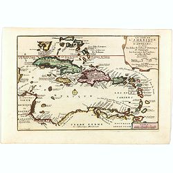
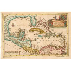
Les Isles De L'Amerique Connues Sous le Nom D'Antilles, ou Sont les Isles de Cuba, St. Domingue et Jamaique les Lucayes, les Caribes . . .
Decorative and detailed map of the Florida Keys, Caribbean and coasts of Central and South America from an early edition of De Fer's "Atlas Curieux". De Fer's m...
Place & Date: Paris, 1705
Selling price: $300
Sold in 2019
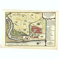
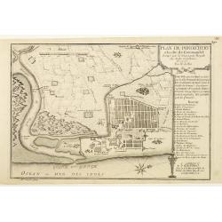
Plan de Pondichery la côte of Coromandel occupé par la Compagnie Royale des Indes cartographic Orientales..
Detailed plan of the town of Pondicherry, founded in 1674 as the capital of French India. A masterpiece of European Enlightenment Era urban planning, it was predicated on...
Place & Date: Paris, 1705
Selling price: $250
Sold in 2020
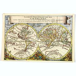
Algemeene Wereldkaart van den Aardkloot. In twee Vlakronden vertoont, en naar de niewste Beschryvingen overzein en verbetert. . .
This delightful double hemisphere map is beautifully decorated with clouds at the top and excellent allegorical representations of the known continents at the bottom. Cal...
Place & Date: Amsterdam, ca 1705
Selling price: $300
Sold in 2019
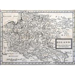
Poland. According to ye newest observations. . .
A small but detailed map of Poland, the Ukraine, Lithuania, Latvia, and parts of Russia. Extends from Vienna to Moscow, including Riga, Warsaw, Kaliningrad, Kiev, and man...
Place & Date: London, ca 1705
Selling price: $47
Sold in 2019

Grece Moderne ou Partie Meridionale de la Turquie en Europe.
A detailed map of the Southern Part of Greece and contiguous Islands. From De Fer's “Atlas Curieux”. Engraved by Van Loon. It comes with a page entitled “Descripti...
Place & Date: Paris, 1705
Selling price: $140
Sold in 2021
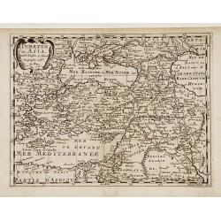
Turkyen in Asia.
Attractive general map of the Middle East, including Turkey, Cyprus, Palestine, etc.
Place & Date: Amsterdam 1705
Selling price: $80
Sold
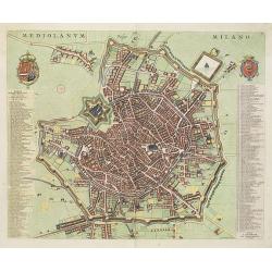
Mediolanum. Milano.
A beautifully engraved and richly decorated plan of Milan. With a key (1-256) in left and right referring to the principal places of interest in the town.Joan Blaeu publi...
Place & Date: Amsterdam, 1704 / 1705
Selling price: $1600
Sold in 2022
Iukatan en vaste kusten van Nieuw Spanje..
An attractive map showing the Caribbean.Although not renowned for the originality of his work, Pieter van der Aa is highly thought of for the design and quality of his ou...
Place & Date: Leiden 1705
Selling price: $255
Sold
![[Title page]](/uploads/cache/15729-250x250.jpg)
[Title page]
Beautiful title page by Ottens from the famous book about the butterflies of Suriname. Maria Sybilla Merian is shown with six putti observing various floral species and b...
Place & Date: Amsterdam, 1705
Selling price: $250
Sold
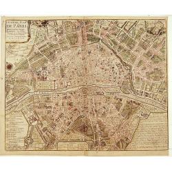
Huitième Plan DE PARIS Divisé en ses Vingts Quartiers.
Beautifull plan of Paris showing the new districts built under the reign of Louis XIV. Description and legends in the margins.
Place & Date: Paris 1705
Selling price: $215
Sold
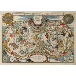
Planispheres Celeste . Par Mr. De la Hire..
Decorative double hemisphere celestial chart, centred on the north and south poles. The constellation figures are derived from the prototypes in Bayer's Uranometria and t...
Place & Date: Paris 1705
Selling price: $710
Sold
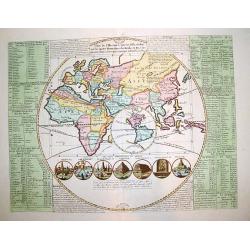
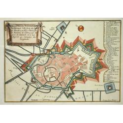
Plan de l\'Histoire universelle, oulon voit les quatre Monarchies du Monde, et tous les Ancien Etats aussi bien que ceux qui subsistent aujourdhuy.
A very interesting map with a unique composition and presentation depicting the entire world, but with emphasis on the OLD WORLD.The central map shows the Eastern Hemisph...
Place & Date: Amsterdam, ca. 1705
Selling price: $620
Sold
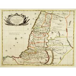
Terra promissa in sortes seu tribus XII?
The promised Land divided among the 12 Tribes according to the Book of Joshua. Shows Palestine on both sides of the Jordan, the shoreline running from Sidon as far as Rhi...
Place & Date: Amsterdam 1705
Selling price: $250
Sold
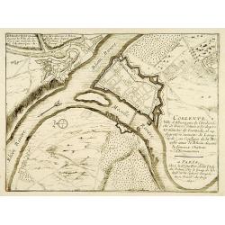
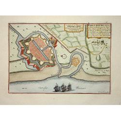
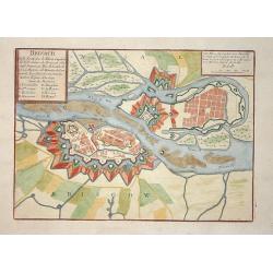
Lot of 2 maps.
2 city plans : Coblentz, ville d'Allemagne.. / Brisach ville forte sur le Rheim?
Place & Date: Paris c.1705
Selling price: $20
Sold
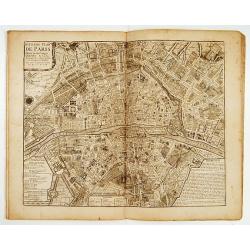
Atlas curieux Paris.
A fine series of 10 double page plans of Paris (c.450x530mm) showing the town's development during several ages. Prepared by Jean-Baptiste Bourguignon d' Anville,(1697-17...
Place & Date: Paris 1705
Selling price: $3750
Sold
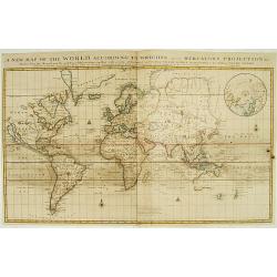
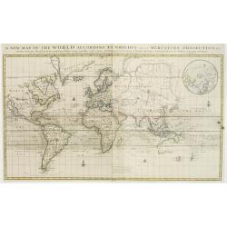
A new map of the world according to the New Observations..
A world map in Mercator projection, showing California as an island. In right hand corner smaller inset of the North Pole.From Harris, A complete collection of Voyages an...
Place & Date: London 1705
Selling price: $1000
Sold
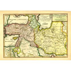
La Perse La Georgie, et la Turquie d'Asie..
Uncommon map of Turkey, Persia, Palestine and the northern tip of Arabia.
Place & Date: Paris, 1705
Selling price: $100
Sold in 2009
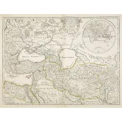
Theatrum Historicum.. Tu Imperii Romani.. Pars Orientalis..
Showing the Eastern part of the Roman Empire, extending from Greece and Cyprus to India and centered on Armenia and the Black and Caspian Seas. Prepared by G. de l'Isle, ...
Place & Date: Paris, 1705
Selling price: $200
Sold in 2009
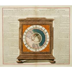
Geographische Universal-Zeig und Slag-Uhr.
An unrecorded, separately published sheet in order to explain the use and promote the newly invented clock showing the different times around the world.The world centered...
Place & Date: Nuremberg, 1705
Selling price: $1800
Sold in 2013
Les environs de NAMUR, de Huy et de Charle-roy..
Detailed map of the region of Namen, by Nicolas De Fer, who was a royal French geographer.
Place & Date: Paris 1705
Selling price: $20
Sold
Les environs de DINANT, de Philippeville et de Charlemont..
Detailed map of the region of Dinant, by Nicolas De Fer, who was a royal French geographer.
Place & Date: Paris 1705
Selling price: $20
Sold
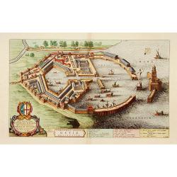
Utriusque Portus Ostiae Delineatio.
A most attractive and fascinating bird's eye plan of this small port near the mouth of the Tiber. Dedicated to Cornelis Witsen, senator of Amsterdam and traveller. Joan B...
Place & Date: Amsterdam, 1705
Selling price: $1300
Sold in 2013
![[Title page] Algemene Wereldbeschryving..](/uploads/cache/21225-250x250.jpg)
[Title page] Algemene Wereldbeschryving..
In lower part small vignette (37x64mm)
Place & Date: Amsterdam 1705
Selling price: $32
Sold
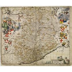
Pedemontium et reliquae ditiones Italiae regiae celsitudini Sabaudicae ..
Map of Piemonte in northern Italy with Turin in the centre. Heraldic title cartouche, numerous coats of arms with cherubs down both sides and figurative scale of miles. T...
Place & Date: Amsterdam 1705
Selling price: $280
Sold
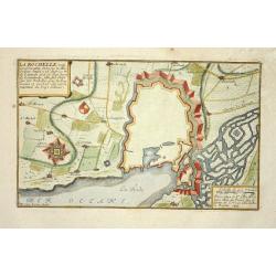
La Rochelle
Nice city plan of La Rochelle with the fortification walls and the port at the ocean.
Place & Date: Paris 1705
Selling price: $40
Sold
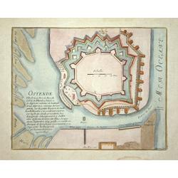
Ostende
Nice city plan of Oostende with the fortification walls and the port.
Place & Date: Paris 1705
Selling price: $45
Sold
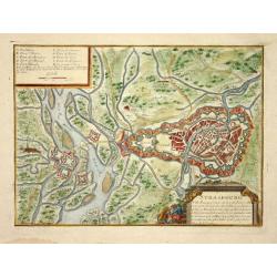
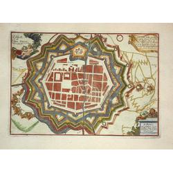
Strasbourg
Nice city plan of Strasburg with the fortification walls at the river Rhine.
Place & Date: Paris 1705
Selling price: $105
Sold
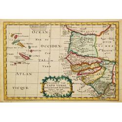
D' Eilanden van Capo Verde, de kust en 't landt der Negeren.
Nicolas Sanson (1600-67), ' father of the French cartography' and founder of the Sanson firm. Atlas ' Cartes générales de toutes les parties du Monde', 1658-70 and a po...
Place & Date: Amsterdam, F. Halma, 1705
Selling price: $95
Sold in 2009
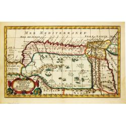
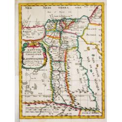
T koninkryk en de Woestyne van Aegypten.
Nicolas Sanson (1600-67), ' father of the French cartography' and founder of the Sanson firm. Atlas ' Cartes générales de toutes les parties du Monde', 1658-70 and a po...
Place & Date: Amsterdam, F. Halma, 1705
Selling price: $85
Sold in 2016
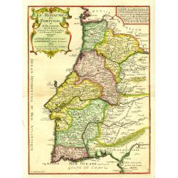
Les Royaumes de Portugal et d'Algarve..
Uncommon map of Portugal, engraved by P.Strackman.
Place & Date: Paris, 1705
Selling price: $130
Sold in 2015
Le comte de Namur, partie de L'Evesche de Liege, du Luxembourg ..
Detailed map centered on Naman, and including part of Luxemburg.
Place & Date: Paris, 1705
Selling price: $40
Sold

Algemeene Wereldbeschrijving..Asia, Africa en America.
Decorative allegorical title page.
Place & Date: Amsterdam 1705
Selling price: $60
Sold
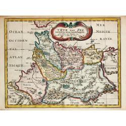
' T Ryk van Fez verdeelt in zeven Landschappen
Nicolas Sanson (1600-67), ' father of the French cartography' and founder of the Sanson firm. Atlas ' Cartes générales de toutes les parties du Monde', 1658-70 and a po...
Place & Date: Amsterdam, F. Halma, 1705
Selling price: $100
Sold in 2009
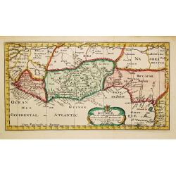
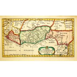
Guinee.
Nicolas Sanson (1600-67), ' father of the French cartography' and founder of the Sanson firm. Atlas ' Cartes générales de toutes les parties du Monde', 1658-70 and a po...
Place & Date: Amsterdam, F.Halma, 1705
Selling price: $85
Sold
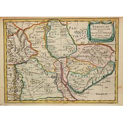
Paraguay.
Nicolas Sanson (1600-67), ' father of the French cartography' and founder of the Sanson firm. Atlas ' Cartes générales de toutes les parties du Monde', 1658-70 and a po...
Place & Date: Amsterdam, F. Halma, 1705
Selling price: $150
Sold
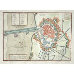
Ausbourg.
Nice city plan of Augsburg.
Place & Date: Paris 1705
Selling price: $40
Sold
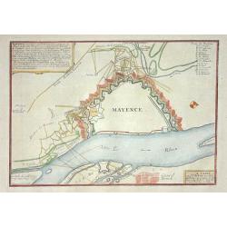
Mayence
Nice city plan of Mainz at the Rhine river.
Place & Date: Paris 1705
Selling price: $35
Sold
Donquerque
Nice city plan of Donquerque.
Place & Date: Paris 1705
Selling price: $40
Sold
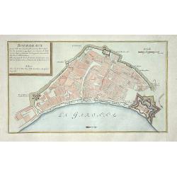
Bordeaux
Nice city plan of Bordeaux.
Place & Date: Paris 1705
Selling price: $50
Sold
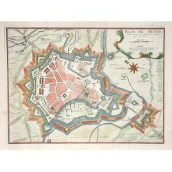
Plan de Menin
Nice city plan of Menin.
Place & Date: Paris 1705
Selling price: $40
Sold
Gravelines
Nice city plan of Gravelines.
Place & Date: Paris 1705
Selling price: $60
Sold
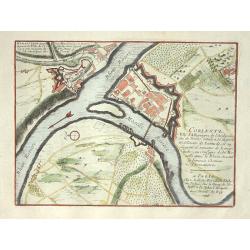
Coblentz
Nice city plan of Coblenz at the Rhine and Moesel river.
Place & Date: Paris 1705
Selling price: $65
Sold
Bethune
Nice city plan of Bethune.
Place & Date: Paris 1705
Selling price: $50
Sold
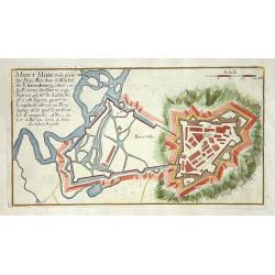
Mont Midi.
Nice plan of Mont Midi in Luxemburg.
Place & Date: Paris 1705
Selling price: $40
Sold
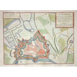
Oudenarde
Nice city plan of Oudenaarde.
Place & Date: Paris 1705
Selling price: $50
Sold
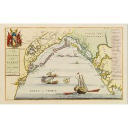
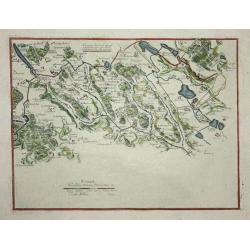
Les Environs de Venise.
Showing in great detail the port of Venice. Includes also a numbered key legend on the right side.Joan Blaeu published during his life three town-books of Italy: Citta de...
Place & Date: Amsterdam, 1705
Selling price: $700
Sold in 2009
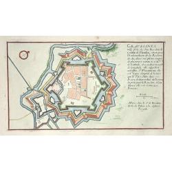
Carls-Bourg
Nice city plan of CarlsBerg near Bremen with the fortification walls at the Weser river.
Place & Date: Paris 1705
Selling price: $45
Sold
Stetin.
Nice city plan of Stetin with the fortification walls at the Oder river.
Place & Date: Paris, 1705
Selling price: $55
Sold
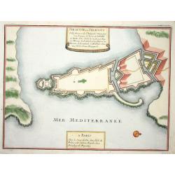
Fribourg.
Nice city plan of freiburg with the fortification walls.
Place & Date: Paris 1705
Selling price: $85
Sold
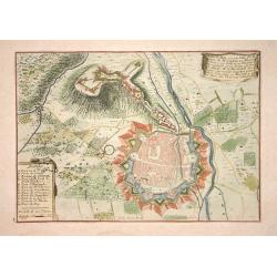
Brisach.
Nice city plan of Brisach with the fortification walls around the city at the Rhine river.
Place & Date: Paris 1705
Selling price: $70
Sold
Landau.
Nice city plan of Landau near Karlsruhe with the fortification walls.
Place & Date: Paris 1705
Selling price: $75
Sold

Bayonne.
Nice city plan of Bayonne with the fortification walls around the city.
Place & Date: Paris 1705
Selling price: $70
Sold
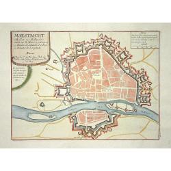
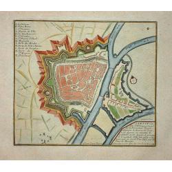
Maestricht.
Nice city plan of Maastricht in the Southern part of The Netherlands.
Place & Date: Paris 1705
Selling price: $85
Sold
Egypten, verdeelt in zyne twaalf Cassilifen of Landvoogdyen.
An attractive map of Egypt from Nicolas Sanson's pocket atlas. Nicolas Sanson (1600-67), the father of the French cartography' and founder of the Sanson firm. Published a...
Place & Date: Amsterdam, F. Halma, 1705
Selling price: $75
Sold in 2019
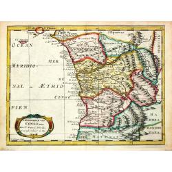
T Koninkrijk van Congo.
Nicolas Sanson (1600-67), ' father of the French cartography' and founder of the Sanson firm. Atlas ' Cartes générales de toutes les parties du Monde', 1658-70 and a po...
Place & Date: Amsterdam, 1705
Selling price: $75
Sold in 2017
A new map of the world according to Wrights alias Mercator Projection &c..
A Large, almost wall map of the world map in Mercator projection, showing California as an island. In right hand corner smaller inset of the North Pole.From Harris, A com...
Place & Date: London, 1705
Selling price: $2500
Sold in 2008
Plan de Pondichery la côte of Coromandel occupé pair la Compagnie Royale DES Indes cartographic Orientales..
Detailed plan of the town of Pondichery, by Nicolas De Fer, who was a royal French geographer.
Place & Date: Paris 1705
Selling price: $72
Sold
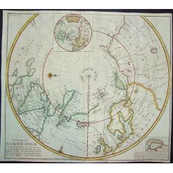
This Draught of the North Pole...to find out the N. East and N. West Passages
A boldly engraved chart of the polar region that shows the latest discoveries and routes of various explorers during their attempts to find a Northwest and Northeast pass...
Place & Date: London, ca. 1705
Selling price: $375
Sold in 2008
Siracuse
Nice city plan of Siracuse with the fortification walls.
Place & Date: Paris 1705
Selling price: $120
Sold
Carmagnole
Nice city plan of Carmagnole with the fortification walls.
Place & Date: Paris 1705
Selling price: $70
Sold
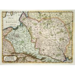
De Staten van de Kroon Poolen.
Detailed map covering the region of present-day Poland, Lithuania, Belarus and Ukraine. Engraved by Anthony d'Winter.
Place & Date: Amsterdam 1705
Selling price: $120
Sold
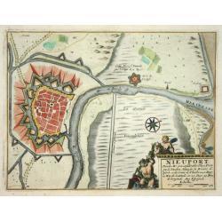
Nieuport
Nice city plan of Nieuport with the fortification walls and the river to the sea.
Place & Date: Paris 1705
Selling price: $50
Sold
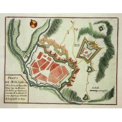
Prats de Moliou.
Nice fortification plan of Prats de Moliou.
Place & Date: Paris 1705
Selling price: $50
Sold
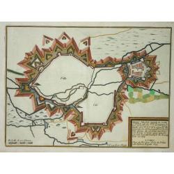
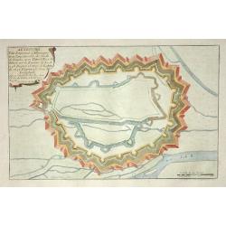
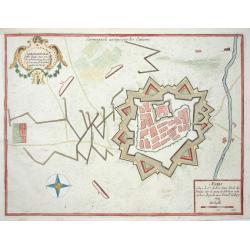
Arras.
Nice fortification plan of Arras.
Place & Date: Paris 1705
Selling price: $60
Sold
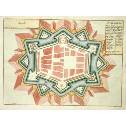
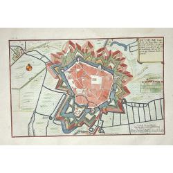
Phalsbourg.
Nice fortification plan of Phalsbourg.
Place & Date: Paris 1705
Selling price: $50
Sold
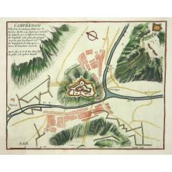
Campredon.
Nice fortification plan of Campredon In the south of France, near the Tarn river.
Place & Date: Paris 1705
Selling price: $40
Sold
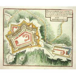
Belle-Garde.
Nice fortification plan of Belle-Garde in the department of Aude.
Place & Date: Paris 1705
Selling price: $50
Sold
Winoxbergen.
Nice city plan of Winoxbergen in Flanders with the fortification walls.
Place & Date: Paris 1705
Selling price: $50
Sold
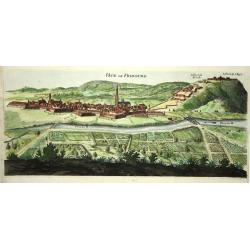
Veue de Fribourg.
Panoramic view of the fortified village of Freiburg in present-day Baden-Württemberg with the Dreisam in the foreground and the forts on the hills protecting the city.
Place & Date: Paris 1705
Selling price: $50
Sold
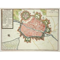
Tournay.
Nice city plan of Tournay in Flanders with the fortification walls and the citadel.
Place & Date: Paris 1705
Selling price: $50
Sold
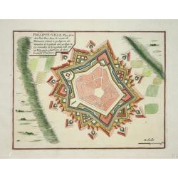
Philippe-ville.
Nice city plan of Philippe-Ville with the fortification walls.
Place & Date: Paris 1705
Selling price: $50
Sold
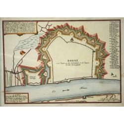
Bonn.
Nice map with Bonn at the Rhine-river.
Place & Date: Paris 1705
Selling price: $50
Sold
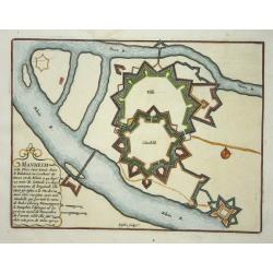
Manheim.
Nice map with Manheim at the Rhine-river.
Place & Date: Paris 1705
Selling price: $50
Sold
Guinee.
Nicolas Sanson (1600-67), ' father of the French cartography' and founder of the Sanson firm. Atlas ' Cartes générales de toutes les parties du Monde', 1658-70 and a po...
Place & Date: Amsterdam, F.Halma, 1705
Selling price: $85
Sold
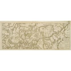
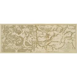
(3 maps) Carte particuliere du Nouveau Canal. Versailles.
This map in three sheets illustrates the canal that would divert water from the Eure River at Pontgouin to Versailles. This massive project was designed by the great mili...
Place & Date: Paris, 1705
Selling price: $80
Sold