Browse Listings
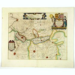
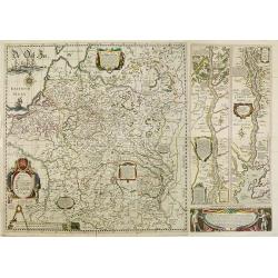
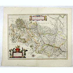
Mechlinia Dominium, et Aerschot Ducatus.
Blaeu's lovely map of the surrounds of Mechelin in central Belgium. In the upper right corner a beautiful title cartouche is seen, embellished with two female figures, on...
Date: Amsterdam, 1645
Selling price: ????
Please login to see price!
Sold in 2020
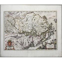
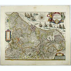
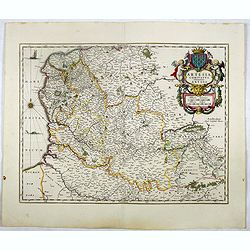
Uplandia.
A nice map of Uplandia, in central Sweden with its capital Stockholm. From 'Theatrum Orbis Terrarum, sive Atlas Novus in quo Tabulæ et Descriptiones Omnium Regionu' by w...
Date: Amsterdam, 1645
Selling price: ????
Please login to see price!
Sold in 2021
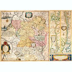
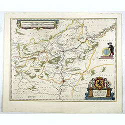
Carte du Pais d'Auvergne.
Map of the Auvergne countryside. Dedicated to the high and powerful seig.r Gaspar de Coligny ... Bottom rightquadrant title and dedication in a cartouche decorated with t...
Date: Paris, 1645
Selling price: ????
Please login to see price!
Sold in 2020
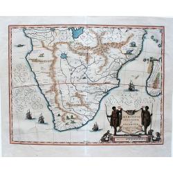
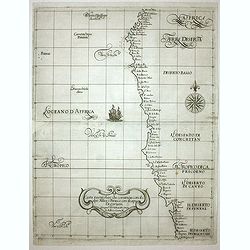
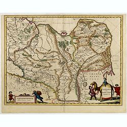
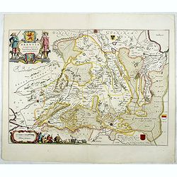
Aethiopia inferior, vel exterior.
A very decorative, large map of South Africa, which became the standard delineation of the region throughout the 17th century. The lake from which the 'Zambere' (the Zamb...
Date: Amsterdam, 1645
Selling price: ????
Please login to see price!
Sold in 2020
![Bern Die Hauptstatt in Nüchtland : ward erbawen durch Berchtoldum den V. Hertzogen zu Zäringen Ao. 1191 und Befreyet von den Keyseren Henrico dem VI. und Friderico dem II. Kam in den Eydgenössichen Bundt Anno 1353 [Berna]](/uploads/cache/84277-250x250.jpg)
Bern Die Hauptstatt in Nüchtland : ward erbawen durch Berchtoldum den V. Hertzogen zu Zäringen Ao. 1191 und Befreyet von den Keyseren Henrico dem VI. und Friderico dem II. Kam in den Eydgenössichen Bundt Anno 1353 [Berna]
Fine early view of Bern, Switzerland, on the Aare River, engraved by Joseph Plep for Matthaus Merian the elder.The map shows a detailed treatment of the city, its main br...
Date: Frankfurt, 1645
Selling price: ????
Please login to see price!
Sold in 2022

Depiction of a cook in his kitchen.
From a series of months after designs of Joachim von Sandrart (1606-1688). Theodor (Dirck) Matham (Haarlem 1605-1676 Amstedam) was a Dutch engraver. Joachim von Sandrart ...
Date: 1645
Selling price: ????
Please login to see price!
Sold in 2021
Portugaliae et Algarbia quae olim Lusitania. Auctore Vernando Alvero Secco.
Willem Blaeu's very fine map of Portugal after Alvaro Secco's map of 1560. Embellished with two cartouches, two coats-of arms and numerous ships, compass-roses and a sea ...
Date: Amsterdam, ca. 1645
Selling price: ????
Please login to see price!
Sold in 2021
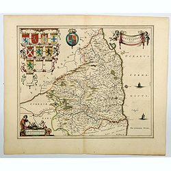
Comitatus Northumbria, Vernacule Northumberland. . .
A double-page map of Northumberland county with a decorative title cartouche and scale bar, eight family coats of arms and three blank shields at left. Superbly engraved ...
Date: Amsterdam, ca 1645
Selling price: ????
Please login to see price!
Sold in 2023
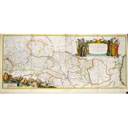
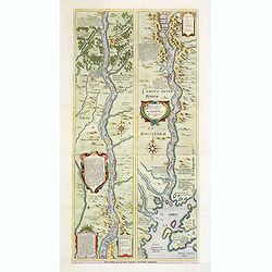
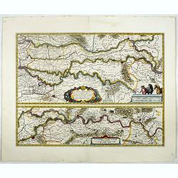
Danubius, fluvius Europae maximus, a fontibus ad Ostia, cum omnibus Fluminibus. . .
A striking large-format map of the course of the river Danube on two sheets. Nicely embellished with two large cartouches, a title cartouche with on one side the Kaiser o...
Date: Amsterdam, ca 1645
Selling price: ????
Please login to see price!
Sold in 2022
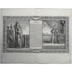
Turkey - Maltese Order, - OSMAN FILS D'IBRAHIM EMPEREUR DES TURCS
Fine antique copper engraving with the portraits of Osman, son of Emperor/Sultan Ibrahim, and of his mother ,an Imperial Concubine. With engraved explanatory text ,in dec...
Date: Paris, 1645
Selling price: ????
Please login to see price!
Sold in 2022
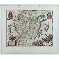
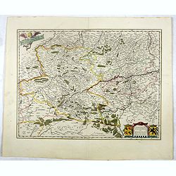
Gothia.
Very decorative map of the southern part of Sweden. The forested topography and lakes are well depicted.The main feature of the engraving is the large title cartouche sur...
Date: Amsterdam, 1645
Selling price: ????
Please login to see price!
Sold in 2023
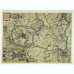
Nieuwe Kaerte van Breda belegert door syne Altesa Frederick Hendrick van Nassou Prince van Orangien . . .
This very rare map appeared only in one atlas: Belgium sive Germania Inferior continens Provincias singulares Septemdecim. iuxta artem Geographicam perfectissime descript...
Date: Amsterdam, 1645
Selling price: ????
Please login to see price!
Sold in 2012
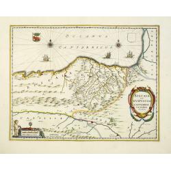
Biscaia et Guipuscoa Cantabriae Veteris Pars.
Janssonius' map of region centered on Bilbao and extending from S. Andero to Calgurris and Baiona. Shows cities of Bilbao and Laredo, and includes a charming vignette of ...
Date: Amsterdam, 1645
Selling price: ????
Please login to see price!
Sold in 2012
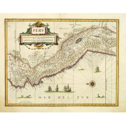
Peru.
Decorative map of Peru, featuring large decorative cartouche, compass rose, four sailing ships and three sea monsters. East to the top. Nearly 100 place names shown.
Date: Amsterdam, c. 1645
Selling price: ????
Please login to see price!
Sold in 2012
Carta particolare che comincia con il c.apo Aldea e Finisce con il capo Degortam.
Dudley’s magnificent chart shows the south west coast of Africa..Engraved by Lucini.Sir Robert Dudley's Dell'Arcano del Mare is the earliest printed sea atlas to cover ...
Date: Florence, 1645
Selling price: ????
Please login to see price!
Sold in 2014
Magni Ducatus Lithuaniae. . . (with) Campus Inter Bohum et Borystenem.. .
This is the famous Radvilas (or Radziwill) map which occupies a very prominent position among works of European cartography from the end of the 16th and the beginning of ...
Date: Amsterdam, 1645
Selling price: ????
Please login to see price!
Sold in 2012
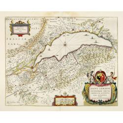
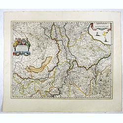
Lacus Lemanni Locorumque circumiacentium Accuratissima descriptio. . .
Row boats and sailing vessels dot the surface of Lake Geneva, which is further enchanted by a compass rose radiating rhumb lines. The lake is surrounded by mountains and ...
Date: Amsterdam, 1645
Selling price: ????
Please login to see price!
Sold in 2015
Tabula Russiae ex autographo, quod delineandum curavit Foedor filius Tzaris Boris desums... - Domino regionum Iueriae Kartalinie et Groefiniae Tzari etc: dedicata ab Heselo Gerardo M.DC.XIIII
A re-issue, by Willem Blaeu, of Hessel Gerritsz' rare and influential map of Russia. Dutch text on verso, extending west to east from Emden to Aspachan and north to south...
Date: Amsterdam, 1645
Selling price: ????
Please login to see price!
Sold in 2013
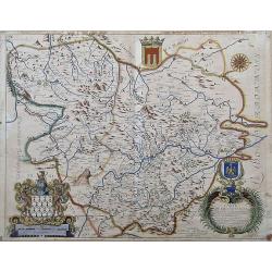
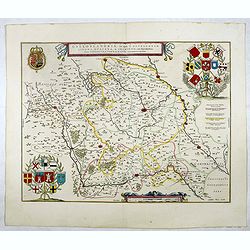
Territorium Metense.
A finely engraved map centered on Metz in France. Cartouche decorated with a chain of leaves and fruits and three coats of arms.The author of this map was the French prin...
Date: Amsterdam, 1645
Selling price: ????
Please login to see price!
Sold
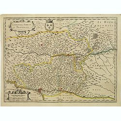
Lionnois, Forest, Beaujolois et Masconnois.
Map of a province of France including the rivers Rhone and Loire north of Lyon.The first state before the signature of Johannes Janssonius was added. No text on verso. Fr...
Date: Amsterdam, c. 1631 and before 1645
Selling price: ????
Please login to see price!
Sold
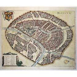
Moscva
Great bird's-eye plan displaying Moscow situated at the junction of the Moskva and Neglinnaya Rivers, which form a moat protecting all but the northeast flank of the Krem...
Date: Frankfurt ca. 1645
Selling price: ????
Please login to see price!
Sold in 2013
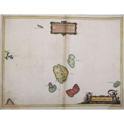
Insulae Quaedam Minores ex Aebudis quae Mulam et Skiam. . .
Insulae Quaedam Minores ex Aebudis quae Mulam et Skiam…c1634 by Joan Blaeu after Timothy Pont. Sub-titled "Some of the Smaller Western Yles, lying between the Yles...
Date: Amsterdam, 1645
Selling price: ????
Please login to see price!
Sold in 2012
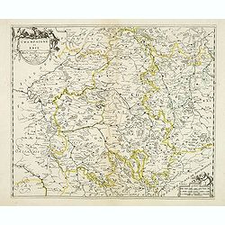
Champagne et Brie. Par Mr. Sanson geographe du Roy. . .
Early imprint of this fine map of the Champagne-Ardenne area, embellished with decorative title cartouche and scale cartouche with putti and surveying instruments. Paris,...
Date: Paris, ca. 1645
Selling price: ????
Please login to see price!
Sold in 2012
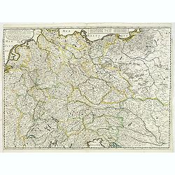
Carte generale de L'Empire d'Allemagne et pays circonvoisins. . .
Early imprint of this fine map of Germany, Poland, Low countries, Switzerland and Austria. The map was first published by Tavernier and later by Mariette. This edition ca...
Date: Paris, 1642 -1645
Selling price: ????
Please login to see price!
Sold in 2023
Hannonia, Pays de Haynault Tenu de Dieu & du Soleil.
Detailed copper engraved map of Hainaut, a province in Wallonia, a region of Belgium. It has three strapwork cartouches. From Ludovico Guicciardini's "Description d...
Date: Amsterdam, 1645
Selling price: ????
Please login to see price!
Sold in 2013
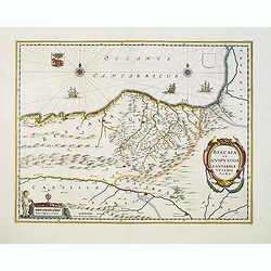
Biscaia et Guipuscoa Cantabriae Veteris Pars.
A nice example of Janssonius map of region centered on Bilbao and extending from S. Andero to Calgurris and Baiona. Shows cities of Bilbao and Laredo, and includes a char...
Date: Amsterdam, 1645
Selling price: ????
Please login to see price!
Sold in 2020
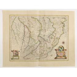
Campus Inter Bohum et Borystenem.
A handsome map of the Dnieper River.As Willem Blaeu died in 1638 most of his maps are actually published by his son Joan. This maps carries his (engraved) signature and w...
Date: Amsterdam, 1645
Selling price: ????
Please login to see price!
Sold in 2013
Magni Ducatus Lithuaniae. . . (with) Campus Inter Bohum et Borystenem.. .
This is the famous Radvilas (or Radziwill) map which occupies a very prominent position among works of European cartography from the end of the 16th and the beginning of ...
Date: Amsterdam, 1645
Selling price: ????
Please login to see price!
Sold in 2014
Champagne latine Campania, comitatus.
A good engraved map embellished with decorative scale cartouches showing two putti with a globe.
Date: Amsterdam, 1645
Selling price: ????
Please login to see price!
Sold in 2020
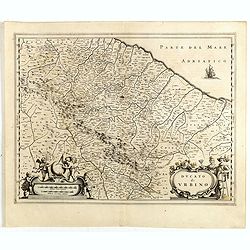
Ducato di Urbino.
Detailed map of Umbria region with Urbino and the eastern coastline. Shows ports, fortified cities and the mountains of Umbria. Some remains of old coloring still visible...
Date: Amsterdam, 1645
Selling price: ????
Please login to see price!
Sold in 2014
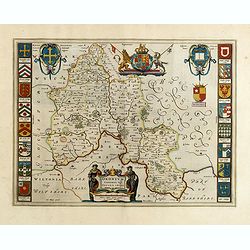
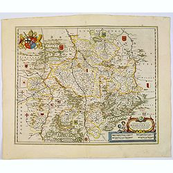
Oxonium Comitatus, Vulgo Oxford shire.
Double-page map of the county of Oxford on the Thames River. This English county map is highly decorative with figurative title cartouche of two scholars. Royal arms and ...
Date: Amsterdam, 1645
Selling price: ????
Please login to see price!
Sold in 2015
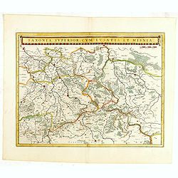
Saxonia Superior, cum Lusatia et Misnia.
Finely engraved and detailed map of Saxony including Halle, Leipzig, Meissen, and Dresden. Filled with forests and tiny villages. It presents Prague close to the center o...
Date: Amsterdam, 1645
Selling price: ????
Please login to see price!
Sold in 2016
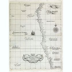
Carta particolare che comincia con il c.apo Aldea e Finisce con il capo Degortam.
Dudley’s magnificent chart shows the south west coast of Africa. A first edition without the privilege..Engraved by Lucini.Sir Robert Dudley's Dell'Arcano del Mare is ...
Date: Florence, 1645
Selling price: ????
Please login to see price!
Sold in 2015
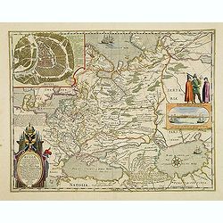
Tartariae sive Magni Chami Imperium.
Fine map of Tartary, including northern part of China, and tip of Korea.
Date: Amsterdam, 1645
Selling price: ????
Please login to see price!
Sold in 2015
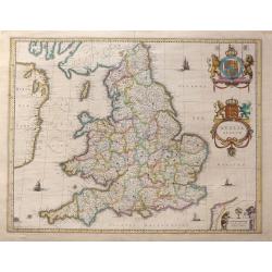
Anglia Regnum.
Willem Blaeu was the first to bring out a new map of England and Wales. The outline and place names are taken from Speed with county boundaries marked but no border figur...
Date: Amsterdam, 1645
Selling price: ????
Please login to see price!
Sold in 2016
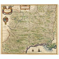
Languedoc.
Embellished with decorative and scale cartouches, double coat of arms, compass rose and ship.
Date: Amsterdam, 1645
Selling price: ????
Please login to see price!
Sold in 2015
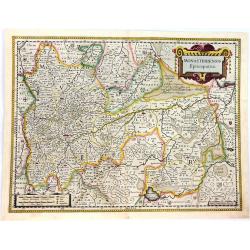
Monasteriensis Episcopatus.
A beautifully detailed map of Germany, centred on Munster and Linge. The map is decorated with several small coats of arms pertaining to the main cities.There is a striki...
Date: Amsterdam, 1645
Selling price: ????
Please login to see price!
Sold in 2016
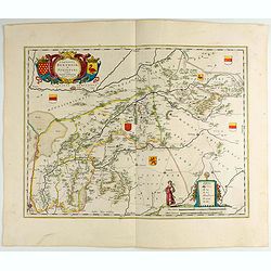
Comitatus Bentheim et Steinfurt.
An excellent and early map of the former county of Bentheim (Lower Saxony) and Steinfur (North Rhine-Westphalia) and bordering areas in Germany. Very decorative title car...
Date: Amsterdam, 1645
Selling price: ????
Please login to see price!
Sold in 2022
Episcopatus Hildesiensis de Scriptio Novissima.
A fine mid-17th century copper engraved map of the region around Hildesheim, in Lower Saxony. It includes numerous cities and corresponding coat of arms held by a lion on...
Date: Amsterdam, 1645
Selling price: ????
Please login to see price!
Sold in 2016
Insulae Divi Martini et Viliarus Vulgo L'Isle de Re et Oleron.
A very decorative map in the islands of Ré and Oléron, off the Atlantic coast of France. It includes a title cartouche decorated with mermaids and a scale cartouche wit...
Date: Amsterdam, 1645
Selling price: ????
Please login to see price!
Sold in 2016
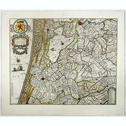
Flandriae Partes duae quarum altera proprietaria . . .
Splendid map of Flanders centered on Gent. in lower right corner Antwerp and Vlissingen in top right. At bottom left a very decorative cartouche with a dedication to Jaco...
Date: Amsterdam, ca. 1645
Selling price: ????
Please login to see price!
Sold in 2018
Alsatia Landgraviatus cum Suntgoia et Brisgoia.
Large map of Alsace based on the work of Gerard Mercator. Covers the region including the Rhine from Granville to Sarburg in the north and from Basel to Landaw in the sou...
Date: Amsterdam, 1645
Selling price: ????
Please login to see price!
Sold in 2018
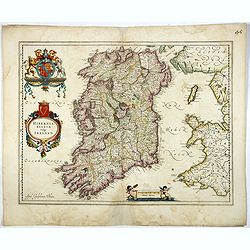
Hibernia regnum vulgo Ireland.
Standard map of Ireland embellished with decorative coat of arms, cartouche with title and a scale cartouche showing two putti. The map is heavily based on an earlier map...
Date: Amsterdam, 1645
Selling price: ????
Please login to see price!
Sold in 2017
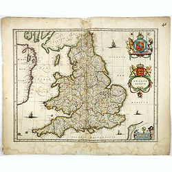
Anglia Regnum.
Willem Blaeu was the first publisher to bring out a new map of England and Wales. The outline and place names are taken from Speed with county boundaries marked but no bo...
Date: Amsterdam, 1645
Selling price: ????
Please login to see price!
Sold in 2017
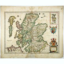
Scotia Regnum.
A attractive example of this fine map of Scotland with two coats of arms and an in-set map of the Orkney Islands.
Date: Amsterdam, ca.1645
Selling price: ????
Please login to see price!
Sold in 2017
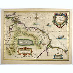
Guiana sive Amazonum Regio.
Important map extending from the Isla Margarita in the northwest to the coast of northern Brazil near Sao Luis east of the Amazon delta. The map locates at its center a l...
Date: Amsterdam, ca.1645
Selling price: ????
Please login to see price!
Sold in 2018
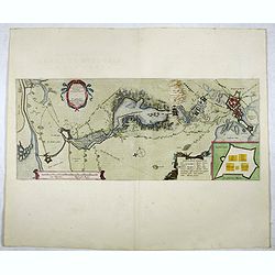
Tabula Castelli ad Sandflitam,..Bergas ad Zomam et Antverpi
East is at the top. The map pictures the complex military situation that had developed after the Dutch blockade of Antwerp. All entrenchment's and fortresses marked by a ...
Date: Amsterdam, 1645
Selling price: ????
Please login to see price!
Sold in 2017
Tabula Bergarum ad Zoman Stenbergae.
This map shows the city of Bergen op Zoom in Brabant.
Date: Amsterdam, 1645
Selling price: ????
Please login to see price!
Sold in 2018
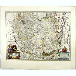
Quarta pars Brabantiae cujus caput Sylvaducis.
The coat of arms of Brabant and 's-Hertogenbosch appear on the map. As this is an early state of this map, the municipal arms in the columns on right and left-hand side h...
Date: Amsterdam, 1645
Selling price: ????
Please login to see price!
Sold in 2018
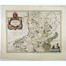
Ducatus Limburgum.
Decorative map of Dutch and Belgium Limburg that is centered roughly on the Meuse River (Latin Mosa) and its cities of Hoy, Liege, and Maastricht. Finely detailed to show...
Date: Amsterdam, 1645
Selling price: ????
Please login to see price!
Sold in 2018
Lutzenburg Ducatus.
Staéndard map of Luxemburg. More about maps by Willem Blaeu. [+]
Date: Amsterdam, 1645
Selling price: ????
Please login to see price!
Sold in 2019
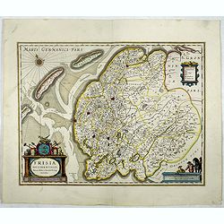
Frisia Occidentalis.
Map of Friesland. The main towns are shown by miniature plan, attractive title cartouche bottom left, key cartouche top right, scale cartouche bottom right.More about map...
Date: Amsterdam, 1645
Selling price: ????
Please login to see price!
Sold in 2020
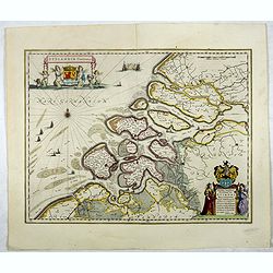
Zeelandia Comitatus.
Standard map of Zeeland with small parts of Holland and Flanders.More about maps by Willem Blaeu. [+]
Date: Amsterdam, 1645
Selling price: ????
Please login to see price!
Sold in 2017
Delflandia, Schielandia.
This finely engraved map by Willem Blaeu shows the estuary of the River Maas and includes the area from 's-Gravenhage to Gouda to Steenbergen and Ouddorp. Includes Rotter...
Date: Amsterdam, 1645
Selling price: ????
Please login to see price!
Sold in 2021
Zuydhollandia stricte sumta.
The count ship of Holland was subdivided into a number of bailiwicks. The most southerly bailiwick, bordering on Brabant was named Zuid-Holland. Many floods changed the a...
Date: Amsterdam, 1645
Selling price: ????
Please login to see price!
Sold in 2019
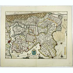
Rhenolandiae et Amstellandiae.
Encompasses the area between 's-Gravenhage and Gouda in the south, to Beverwijk in the north. Large expanse of the Haarlemmermeer occupies the centre of the plate. A very...
Date: Amsterdam, 1645
Selling price: ????
Please login to see price!
Sold in 2017
Hollandiae pars septentrionalis, Vulgo Westvriesland..
Based on the work of B.F.van Berckenrode, this fine map, orientated west to the top of the sheet, includes Kennemerland and Hollands Noorderkwartier and is a reasonably u...
Date: Amsterdam, 1645
Selling price: ????
Please login to see price!
Sold in 2017
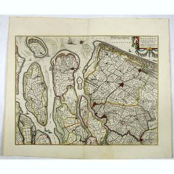
Tractus Rheni et Mosae totusq Vahalis.
Shows that part of the central Netherlands where the three great rivers flow to within but a few kilometers of each below Wesel. The scale allows most of the larger towns...
Date: Amsterdam, 1645
Selling price: ????
Please login to see price!
Sold in 2017
Geldria Ducatus et Zutphania Comitatus.
Map of Gelderland orientated west at the top, including Northern Limburg, eastern part of Brabant, Veluwe and Zutphen. Including the towns of Utrecht, Enschede, Rhunbeck,...
Date: Amsterdam, 1645
Selling price: ????
Please login to see price!
Sold in 2018
Novus XVII Inferioris Germaniae Provinciarum Typus.
One of the most decorative maps of present Netherlands, Belgium and Luxembourg.With the signature of "Willem Blaeu op't Water in de Vergulde Zonnewyzer."Superb ...
Date: Amsterdam, 1645
Selling price: ????
Please login to see price!
Sold in 2017
Brabantia Ducatus.
West is at the top. On the lower left a magnificent cartouche with a sitting female figure carrying a globe and compasses and the coat of arms of Brabant. The map enclose...
Date: Amsterdam, 1645
Selling price: ????
Please login to see price!
Sold in 2018
Prima pars Brabantiae cuius caput Lovanium.
Decorative map centered on Tienen and Leuven. West to the top.More about maps by Willem Blaeu. [+]
Date: Amsterdam, 1645
Selling price: ????
Please login to see price!
Sold
Flandriae Teutonicae pars orientalior.
Detail of the eastern part of Flemish Flanders: the Liberty of Bruges with the island of Cadzand. . . The towns of Ghent, Sluis, Bruges, Ostend and many others.More about...
Date: Amsterdam, 1645
Selling price: ????
Please login to see price!
Sold in 2020
Artesia Comitatus. Artois.
Very decorative map of north-western part of France.As Willem Blaeu died in 1638 most of his maps are actually published by his son Joan.More about maps by Willem Blaeu. ...
Date: Amsterdam, 1645
Selling price: ????
Please login to see price!
Sold in 2017
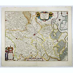
Flandriae Partes duae quarum altera proprietaria . . .
A very detailed map with Gent in the center. Lower right corner Antwerp and Vlissingen in top right. At bottom left a very decorative cartouche with a dedication to Jacob...
Date: Amsterdam, 1645
Selling price: ????
Please login to see price!
Sold in 2021
Galloflandria, in qua Castellaniae Lilana, Duacena, & Orchiesia, cum dependentibus, necnon Tornacum, & Tornacesium. Auctore Martino Doue Gallo-Flandro.
Map of French Flanders. More about maps by Willem Blaeu. [+]
Date: Amsterdam, 1645
Selling price: ????
Please login to see price!
Sold in 2017
Pars Flandriae Teutonicae Occidentalior.
The western part of Teutonic Flanders, spreading from Nieuwpoort to Gravelines, follows the 'Flandriae Teutonicae Pars Orientalior'.More about maps by Willem Blaeu. [+]
Date: Amsterdam, 1645
Selling price: ????
Please login to see price!
Sold in 2020
Secunda pars Brabantiae cuis urbus primaria Bruxellae . . .
At the upper left the title cartouche, decorated with two angels holding the heraldic arms of Brussels, Nijvel and Vilvoorde, next to it that of Brabant.More about maps b...
Date: Amsterdam, 1645
Selling price: ????
Please login to see price!
Sold in 2017
Tertia Pars Brabantiae.
West is at the top. At the lower left the cartouche embellished with male figures with compasses, globe, book and winckel-kruis . At bottom, right of the centre, a beauti...
Date: Amsterdam, 1645
Selling price: ????
Please login to see price!
Sold in 2019
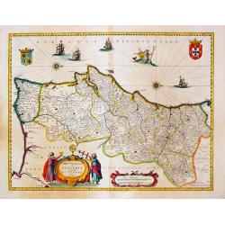
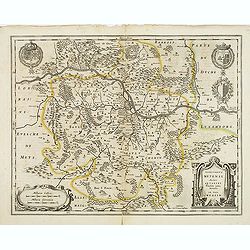
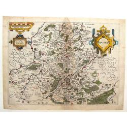
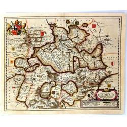
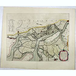
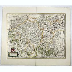
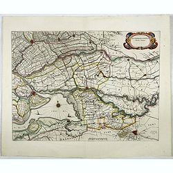
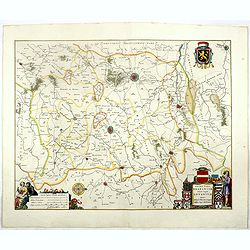
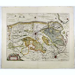
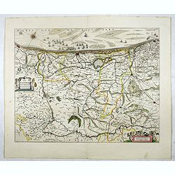
Mechlinia Dominium, et Aerschot Ducatus.
On the upper right a beautiful title cartouche embellished with two female figures of whom the one on the right is Justice. This splendid Blaeu map gives a survey of the ...
Date: Amsterdam, 1645
Selling price: ????
Please login to see price!
Sold in 2017
Leodiensis dioecesis.
West orientated to the top and a pair of fine cartouches to complement this fine Blaeu map including the Dutch province of Limburg and the Belgium province of Namen and A...
Date: Amsterdam, 1645
Selling price: ????
Please login to see price!
Sold in 2017
Namurcum comitatus Auctore Johann Surhonio.
Centred on Namen, prepared by Johan Surhonius. With 3 decorative cartouches. More about maps by Willem Blaeu. [+]
Date: Amsterdam, 1645
Selling price: ????
Please login to see price!
Sold in 2020
Comitatum Hannoniae et Namurci descriptio.
This is Blaeu’s map of the Belgium region of Hainaut and Namur. Numerous towns and villages are on the map. In the lower right corner is the title cartouche with two co...
Date: Amsterdam, 1645
Selling price: ????
Please login to see price!
Sold in 2017
Drentia Comitatus.
Attractive figured cartouche top left, scale cartouche illustrative of the peat digging in the region bottom left.More about maps by Willem Blaeu. [+]
Date: Amsterdam, 1645
Selling price: ????
Please login to see price!
Sold in 2017
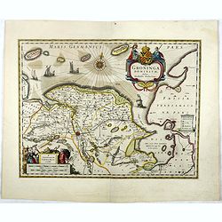
Groninga Dominium.
This finely proportioned, well-designed map was made by the Groningen patrician Barthold Wichering in 1616. An impressive title cartouche top right: key on plinth right c...
Date: Amsterdam, 1645
Selling price: ????
Please login to see price!
Sold in 2017
Ultraiectum Dominium.
Highly detailed map of Utrecht and its surroundings of The Netherlands.More about maps by Willem Blaeu. [+]
Date: Amsterdam, 1645
Selling price: ????
Please login to see price!
Sold
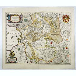
Transiselania Dominium vernacule Over-Yssel.
Map of Overijssel and Drente. Oriented west at the top of the sheet. More about maps by Willem Blaeu. [+]
Date: Amsterdam, 1645
Selling price: ????
Please login to see price!
Sold in 2017
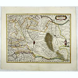
Zutphania Comitatus...
A nice map of the county of Zutphen in Gelderland. The map shows the eastern part of the province as well as a small part of Germany. Important cities named are Arnhem, N...
Date: Amsterdam, 1645
Selling price: ????
Please login to see price!
Sold in 2019
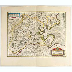
Oldenburg Comitatus.
Willem Blaeu's attractive map of Oldenburg, also depicting Bremen. Some nice calligraphy, decorative title cartouche and mileage scale, rhumb lines and a compass rose fur...
Date: Amsterdam, 1645
Selling price: ????
Please login to see price!
Sold in 2023
Episcopatus Hildesiensis Descriptio Novissima.
This is Blaeu's attractive map centered on the city of Hildesheim. The extensive forests and woodlands of the area are highlighted, as are the rivers Leine and Innerste. ...
Date: Amsterdam, 1645
Selling price: ????
Please login to see price!
Sold in 2017