Browse Listings
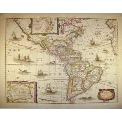
America noviter delineata.
With inset details of the North and South Poles, and several ships and sea-monsters. Hondius shows the imaginary island of Frisland, Southeast of Iceland, and gives Picar...
Date: Amsterdam, 1642
Selling price: ????
Please login to see price!
Sold in 2011
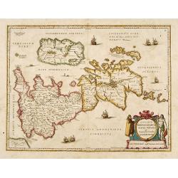
Insularum Britannicarum acurata delineatio. . .
A map of the Roman Britain as seen during the third and fourth centuries. Roman place names as well as Hadrian's Wall and the Wall of Pius appear on the map, identifying ...
Date: Amsterdam, 1642
Selling price: ????
Please login to see price!
Sold in 2022
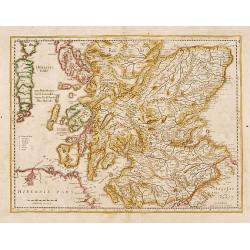
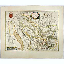
No title: Scotland.
Detailed map of Scotland with Glasgow (Glasquo) in center.
Date: Amsterdam, 1642
Selling price: ????
Please login to see price!
Sold in 2018
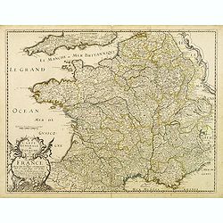
Carte générale du Royaume de France..
This beautifully engraved map depicts France as known in the mid 17th century. Topographical features are shown and major cities, towns, waterways, mountains and islands ...
Date: Paris, 1643
Selling price: ????
Please login to see price!
Sold in 2014
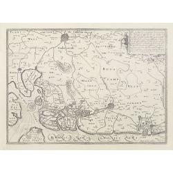
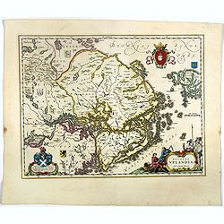
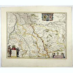
No title. (East Flanders)
Engraved by Kaerius in 1605. The cartouche at top right-hand corner testifies to acts of war from 1600 to 1605.
Date: Amsterdam, 1643
Selling price: ????
Please login to see price!
Sold
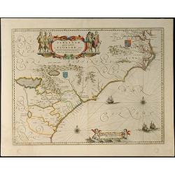
Virginiae Partis australis, et Floridae Partis Orientalis, interjacentiumq, regionum Nova Descripti
Attractive map of the east coast of Virginia and Florida. Second state with small tail at left water-cherub. "One of the many elegantly engraved maps of the Eastern ...
Date: Amsterdam, 1643
Selling price: ????
Please login to see price!
Sold in 2009
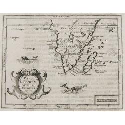
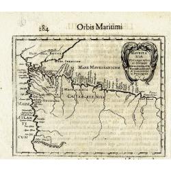
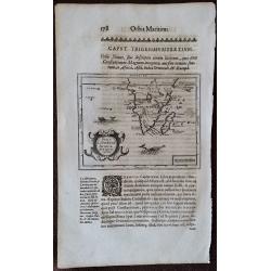
Pars Litorum Africae Antiquis ignota.
Claude Morisot's Scarce Map of the Cape of Good Hope. Map in page of text from Claude Barthélemy Morisot: Orbis Maritimi sive rerum in mari et littoribus gestarum genera...
Date: Dijon, 1643
Selling price: ????
Please login to see price!
Sold in 2008
![[Title page] Le Theatre du Monde ou Nouvel Atlas. . . la seconde partie de la premiere.](/uploads/cache/25951-250x250.jpg)
[Title page] Le Theatre du Monde ou Nouvel Atlas. . . la seconde partie de la premiere.
The frontispiece of the first part of the 'Le Theatre du Monde ou Nouvel Atlas,' by Johan Blaeu.On the right of the title Stadholder Frederik Hendrik, Prince of Orange, o...
Date: Amsterdam 1643
Selling price: ????
Please login to see price!
Sold in 2008
![[No title] - In inset: Habes hic Novam & Accuratissimam Descriptionem Tractus Illius Flandriae?](/uploads/cache/23909-250x250.jpg)
[No title] - In inset: Habes hic Novam & Accuratissimam Descriptionem Tractus Illius Flandriae?
map of Noord-West Vlaanderen, engraved by Petrus Kaerius in 1605. The cartouche at top right-hand corner testifies to acts of war from 1600 to 1605.From: Petri Kaerii Ger...
Date: Amsterdam, 1643
Selling price: ????
Please login to see price!
Sold in 2009
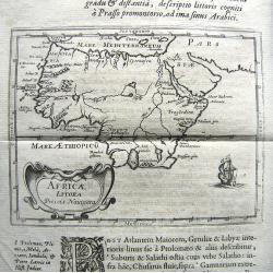
Africae Litora Priscis Navigata.
Rare early map of Africa. The map is printed on a sheet (300x197mm) with Latin text above and below the map and full page of text on the verso. Morisot (1592-1661) was on...
Date: ca. 1643
Selling price: ????
Please login to see price!
Sold in 2010
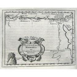
Aegypti Libiae Marmaricae Et Cyrenaicae Tractus Maritimus.
Rare early map of north-east Africa. Morisot (1592-1661) was one of the great intellectuals of his time and his works enjoyed great success. The European expeditions to t...
Date: Dijon, 1643
Selling price: ????
Please login to see price!
Sold in 2011
Tabula Geographica, in qua regiones Cananaeae, et locorum situs. . .
This is the second state of the Petrus Plancius bible map. D.R.M. Mathes , whose identity we don't really know (Doctor Rudolf Mercator, Mathematicus ??), made minimal cha...
Date: Amsterdam, 1643
Selling price: ????
Please login to see price!
Sold in 2010
MAURITANIAE
Rare early map of north-west Africa, showing Algeria and Morocco, and parts of Spain. Only places on the coast, and a few rivers are named. Embellished with a large decor...
Date: Dijon, 1643
Selling price: ????
Please login to see price!
Sold in 2013
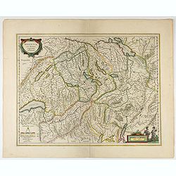
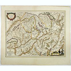
Helvetia cum finitimis regionibus confoederatis.
A typically detailed and finely engraved map of Switzerland by Blaeu, including the cities of Basel, Zürich, Bern, Lucerne, Fribourg, etc. The map is embellished with tw...
Date: Amsterdam, 1643
Selling price: ????
Please login to see price!
Sold in 2021
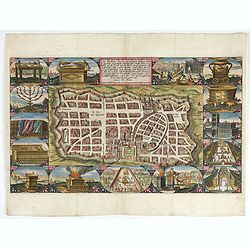
Waerachtige beschryvinge vande wydvermaerde Conincklicke Hooft Stadt Jerusalem.
Engraved by Baptista van Doetechum for a bible printed by Jan Everts Cloppenburg. The bible maps of 1590 are the earliest of Plancius compilations to survive.Very rare pl...
Date: Amsterdam, 1643
Selling price: ????
Please login to see price!
Sold in 2022
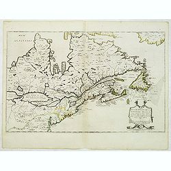
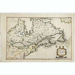
Description de la Nouvelle France ou sont remarquees les diverse habitations des Francois, depuis la premiere descouvert jusques a present, recueillie et dressee sur diverses relations modernes
VERY RARE FIRST STATE, a second state was issued circa 1664. In superb condition. Important GREAT LAKES map first issued in 1643. According to Burden it is actually the f...
Date: Paris, 1643
Selling price: ????
Please login to see price!
Sold in 2012
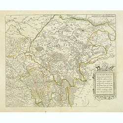
Luxenburgicus ducatus, septem Comitatibus. . .
Map of Luxembourg. Seldom available for purchase. Very rare!Lower right hand corner of copper plate was cut out. Jean Boisseau (fl.1637-1658) French geographer, topograph...
Date: Paris, 1643
Selling price: ????
Please login to see price!
Sold in 2015
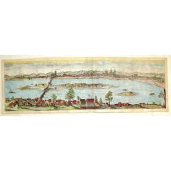
Profil de la Ville Archiepiscopal de Tours Appellee Vulgairement le Jardin de la France, 1643.
Hand-colored copperplate engraving featuring a panoramic view of Tours engraved by the famous master engraver, Hugues Picart (1587-1662). This view is extremely detailed ...
Date: Paris, 1643
Selling price: ????
Please login to see price!
Sold in 2018
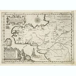
Provincia Britanniae Armoricae Cum confiniis.
Map of the Brittany region in France, published in the rare atlas "Capucins de Rome".
Date: Rome, 1643
Selling price: ????
Please login to see price!
Sold in 2014
Description de la Nouvelle France. . .
Jean Boisseau's edition of Samuel De Champlain's 1632 map, first published in Paris in 1643.Boisseau’s map was the first map derived from Champlain and pre-dates Du Val...
Date: Paris, 1643
Selling price: ????
Please login to see price!
Sold in 2014
Pars Litorum Africae Antiquis ignota.
A map 13.0 x 16.0 cm.(5.1 x 6.3 inches) set in a page of text from Claude Barthélemy Morisot: Orbis Maritimi sive rerum in mari et littoribus gestarum generalis historia...
Date: Dijon, 1643
Selling price: ????
Please login to see price!
Sold in 2015
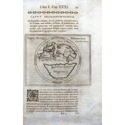
Orbis Antiqui Delineatio secundum Melam.
Very rare map of the ancient world after Pomponius Mela, showing Europe, partial Africa, and Asia, balanced on the south by a large "Antichtones" continent. Sev...
Date: Dijon, 1643
Selling price: ????
Please login to see price!
Sold in 2016
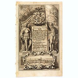
(Title page) Topographia Sueviae dasist . . .
Title page from Casper Merian's Topographia Galliae...
Date: Frankfurt, 1643
Selling price: ????
Please login to see price!
Sold in 2019
(Title page) Topographia Westphaliae . . .
Title page from Casper Merian's Topographia Galliae...
Date: Frankfurt, 1643
Selling price: ????
Please login to see price!
Sold in 2016
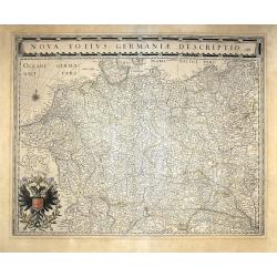
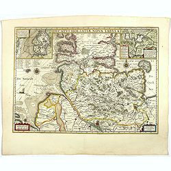
Nova totius germaniae descriptio.
A highly detailed map of the German Empire which covers present-day Germany, Poland, Netherlands, Belgium, Switzerland, Austria, Czech Republic and parts of Poland and Hu...
Date: Amsterdam, 1643
Selling price: ????
Please login to see price!
Sold in 2020
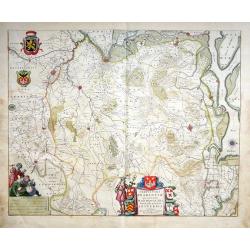
Tertia Pars Brabantiae qua continetur Marchionat S.R.I. horum urbs primaria Antverpia ex Archetypo Michaelis Florenty a Langren Reg. Maj. Mathematico
This map shows a part of the duchy of Brabant in the Netherlands with Antwerp, Loewen towards Breda. The map has eight coat of arms. An attractive figurative title cartou...
Date: Amsterdam, 1643
Selling price: ????
Please login to see price!
Sold in 2020
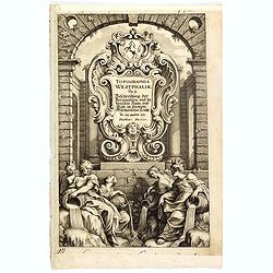
![[Title page ] Topographia Westphaliae . . .](/uploads/cache/36786-250x250.jpg)
[Title page ] Topographia Westphaliae . . .
Title page from Casper Merian's Topographia Westphaliae....
Date: Frankfurt, 1643
Selling price: ????
Please login to see price!
Sold in 2017
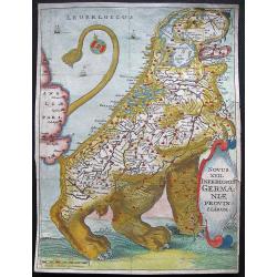
LEO BELGICUS.
A well-known map of the Netherlands in the shape of a Lion. This map is from the first Strada edition issued in the Northern Netherlands. It is the second largest 'Leo Be...
Date: Leiden, 1643
Selling price: ????
Please login to see price!
Sold in 2017
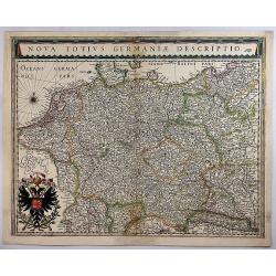
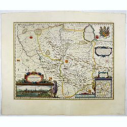
Nova Totius Germaniae Descriptio.
A detailed and finely engraved map of Germany, Poland, Netherlands, Belgium, Austria, and a small part of Italy and Croatia. From the Theatrum Orbis Terrarum.With a titl...
Date: Amsterdam, 1643
Selling price: ????
Please login to see price!
Sold in 2018
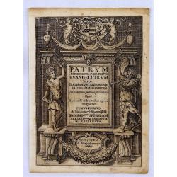
Patrum Intelligentia Super Textum Evangeliorum.
A fine copper engraved frontispiece from "Patrum Intelligentia Super Textum Evangeliorum", by D. Carolum Antonium in 1643. Engraved by Mariae Farroni.
Date: Rome, 1643
Selling price: ????
Please login to see price!
Sold in 2018
Tabula Russiae.
A re-issue, by Willem Blaeu, of Hessel Gerritsz' rare and influential map of Russia.This fine map was compiled from manuscripts brought back from Russia, by Isaac Massa t...
Date: Amsterdam, ca 1643
Selling price: ????
Please login to see price!
Sold in 2018
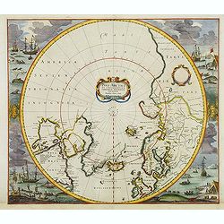
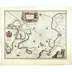
Poli Arctici et Circumiacentium Terrarum Descriptio.
A circular map showing north of Europe and United States. The map is surrounded by scenes of fishing whales. Cartographically the map incorporates much of the knowledge g...
Date: Amsterdam, 1639-1644
Selling price: ????
Please login to see price!
Sold in 2012
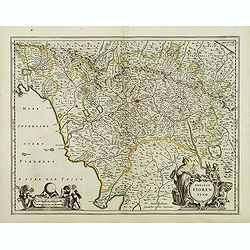
Dominio Fiorentino.
Map of Tuscany region centered on Florence. Sienna, Empoli, S. Miniato, Perugia, Luca, Pisa, Arezzo, and Cortona. Further north the cities of Cesena, Forli and Bertimoro ...
Date: Amsterdam, after 1644
Selling price: ????
Please login to see price!
Sold
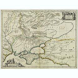
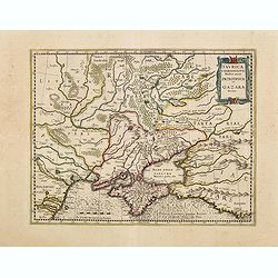
Taurica Chersonesus, Hodie Przecopsca, at Gazara dicitur.
From a French composite atlas.Read more about Dutch - French ties.[+]Detailed map of the Ukraine and surrounding regions between the northern coast of the Black Sea and M...
Date: Amsterdam, after 1644
Selling price: ????
Please login to see price!
Sold in 2016
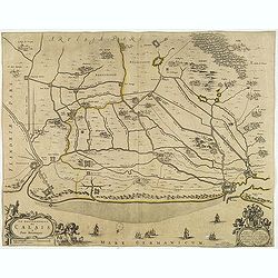
Le gouvernement de Calais & Païs reconquis.
An attractive map of the north-western part of France including the towns of Calais, Gravelines. South to the top. Dedication to Cornelis de Glarges.No text on verso. Fro...
Date: Amsterdam, ca. 1644
Selling price: ????
Please login to see price!
Sold in 2013
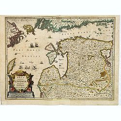
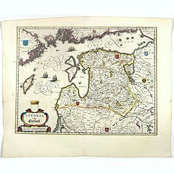
Nova Totius Livoniae accurata Descriptio.
Decorative map of Estonia and Latvia. Including the southern tip of Finland and the south eastern tip of Sweden, including Stockholm.
Date: Amsterdam, 1639-1644
Selling price: ????
Please login to see price!
Sold in 2012
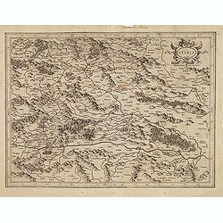
Stiria.
Detailed map of Styria, the most eastern part of Austria, centred on Graz.Signed lower right hand corner Per Gerardum Mercatorem Cum Privilegio.
Date: Amsterdam, 1639-1644
Selling price: ????
Please login to see price!
Sold in 2012
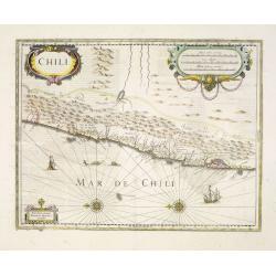
Chili.
Very decorative map of Chili with two large and beautiful cartouches, a compass and ships.
Date: Amsterdam, 1639-1644
Selling price: ????
Please login to see price!
Sold in 2014
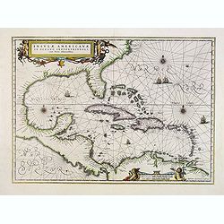
Insulae Americanae in oceano septentrionali.
Showing the Gulf of Mexico and the West Indian Islands, and the adjacent North and South American coastlines. The map is based on the map by Gerritsz., except for the add...
Date: Amsterdam, 1639-1644
Selling price: ????
Please login to see price!
Sold in 2014
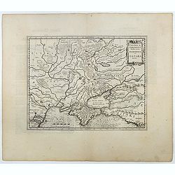
Taurica Chersonesus.
One of the earliest detailed maps of the Crimea and Ukraine between the northern coast of the Black Sea and Moscow.With the signature of Gerard Mercator in lower left cor...
Date: Amsterdam, 1639-1644
Selling price: ????
Please login to see price!
Sold in 2016
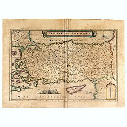
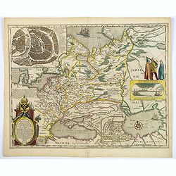
Natoliae Quae Olim Asia Minor.
Blaeu's decorative map of Asia Minor, showing Turkey, Cyprus and the Islands in the Aegean.This attractive map shows all of Turkey, Cyprus and the Aegean Islands to a rel...
Date: Amsterdam, 1644
Selling price: ????
Please login to see price!
Sold in 2016
![[Title Page] Le Theatre du Monde.](/uploads/cache/97205-250x250.jpg)
[Title Page] Le Theatre du Monde.
An engraved title page to "Toonneel Des Aerdrycx, Oft Nieuwe Atlas, Uyutgegven Door Wilhelm En Johan Blaeu". It features the classical figures of Ptolemy (holdi...
Date: Amsterdam, 1644
Selling price: ????
Please login to see price!
Sold in 2018
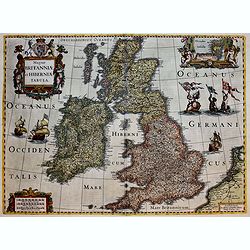
Magnae Britanniae et Hiberniae Tabula.
A splendid finely engraved map of England from the most important Dutch map publishers of the 17th century, the Hondius dynasty.
Date: Amsterdam, 1639-1644
Selling price: ????
Please login to see price!
Sold in 2017
Taurica Chersonesus.
One of the earliest detailed maps of the Crimea and Ukraine between the northern coast of the Black Sea and Moscow.With the signature of Gerard Mercator in lower left cor...
Date: Amsterdam, 1639-1644
Selling price: ????
Please login to see price!
Sold in 2016
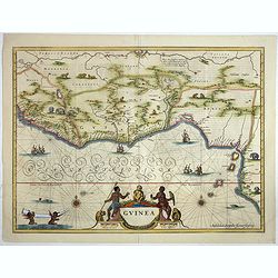
Guinea.
colorful cartouche on the lower border. Two natives sit at the sides of the title, above which is a scroll with flowers and fruit and, in the center, a very human-looking...
Date: Amsterdam, ca. 1644
Selling price: ????
Please login to see price!
Sold in 2018
![[Title page from] Theatrum Orbis Terrarum sive Atlas Novus in quo tabula. . .](/uploads/cache/39236-250x250.jpg)
[Title page from] Theatrum Orbis Terrarum sive Atlas Novus in quo tabula. . .
Attractive title page of Blaeu's New Atlas. Highly decorative, and finely engraved architectural façade with figures.The title is printed on a paste-on slip and surmount...
Date: Amsterdam, 1644
Selling price: ????
Please login to see price!
Sold
Regiones Sub Polo Arctico.
One of the many cases of duplication by the firms of Blaeu and Hondius/Jansson. In this case, Blaeu has copied Janssonius map of 1637. It depicts rhumb lines radiating fr...
Date: Amsterdam, 1644
Selling price: ????
Please login to see price!
Sold in 2017
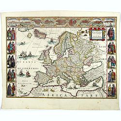
Europa recens descripta à Guilielmo Blaeuw.
On either side columns depicting the manner of dress in the major countries of Europe, surmounted by nine city views and plans.For European mapmakers their own continent ...
Date: Amsterdam, 1644
Selling price: ????
Please login to see price!
Sold in 2017
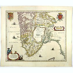
Dioecensis Stavangriensis..
Fine decorative map of southern Norway from 61 deg. N. Oslo, Stavanger and Bergen prominently shown. The map presents a vivid view of the fjords and mountains topography ...
Date: Amsterdam, 1644
Selling price: ????
Please login to see price!
Sold in 2018
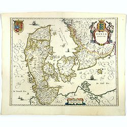
Dania Regnum.
Standard map of Denmark with fine title cartouche and coat of arms.More about Willem Blaeu. [+]
Date: Amsterdam, 1644
Selling price: ????
Please login to see price!
Sold in 2018
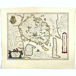
Fionia vulgo Funen
Fine map of Fyn, Langeland and Alsen decorated with three cartouches and a sailing ships. More about Willem Blaeu. [+]
Date: Amsterdam, 1644
Selling price: ????
Please login to see price!
Sold in 2021
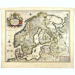
Svecia, Dania, et Norvegia regnae Europe septentrionale.
Famous map of Scandinavia, copied from the wall map (1620) by the Swedish cartographer Andreas Bure (1571-1646).More about Willem Blaeu. [+]
Date: Amsterdam, 1644
Selling price: ????
Please login to see price!
Sold in 2017
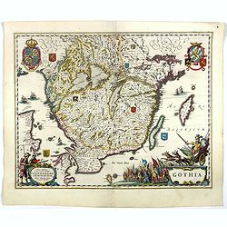
Gothia.
Very decorative map of the southern part of Sweden. The forested topography and lakes are well depicted.The main feature of the engraving is the large title cartouche sur...
Date: Amsterdam, 1644
Selling price: ????
Please login to see price!
Sold in 2017
Ducatus Uplandia.
Nice map of Central Sweden around Stockholm with a decorative cartouche. More about Willem Blaeu. [+]
Date: Amsterdam, 1644
Selling price: ????
Please login to see price!
Sold in 2018
Livonia vulgo Lyefland.
Blaeu's map of Livonia, embellished with a decorative title-cartouche, vessels and 7 coats of arms.More about Willem Blaeu. [+]
Date: Amsterdam, 1644
Selling price: ????
Please login to see price!
Sold in 2017
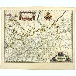
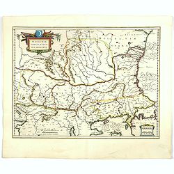
Russiae vulgo Moscovia dictae, Partes Septentionalis et Orientalis.
Covers the northern part of Russia from Finland to just beyond the Jenisej River and south to the Volga River. Includes the cities of Jaroslavl, Niznij Novgorod, and Kaza...
Date: Amsterdam, 1644
Selling price: ????
Please login to see price!
Sold in 2018
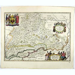
Russiae vulgo Moscovia pars australis. . .
Centered on Moscow. Prepared by Isaac Massa, a Dutch mapmaker who travelled to Russia, returning to Holland in 1609, bringing with him a large amount of original cartogra...
Date: Amsterdam, 1644
Selling price: ????
Please login to see price!
Sold in 2020
Prussia accurate descriptia a Gasparo Henneberg Erlichensi.
Prussia and the Baltic Region, with two large decorative cartouches, coat of arms, and three sailing ships. As indicated in the title cartouche, the map was prepared by t...
Date: Amsterdam, 1644
Selling price: ????
Please login to see price!
Sold in 2017
Polonia regnum et Silesia ducatus.
Very decorative map of Poland embellished with two cartouches and two coats of arms surmounted by cherubs and female figures. Showing the region from the Oder east to Pod...
Date: Amsterdam, 1644
Selling price: ????
Please login to see price!
Sold in 2019
Transylvania Sibenburgen.
Crisply engraved chart of Transylvania, today parts of Hungary and Romania. Nice detail of forested areas, mountain ranges, rivers and towns. Beautifully colored cartouch...
Date: Amsterdam, 1644
Selling price: ????
Please login to see price!
Sold in 2023
Walachia, Servia, Bulgaria, Romania.
Striking map of the region centered on the Lower Danube, Bulgaria, Romania, Serbia and Macedonia. Includes decorative cartouche, coat of arms, etc. Latin text on verso.Th...
Date: Amsterdam, 1644
Selling price: ????
Please login to see price!
Sold in 2017
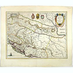
Sclavonia, Croatia cum Dalmatiae Parte.
Important map by Blaeu with a set of three coat-of-arms hinting at the regions history as they reflect the Ottoman Empire, the Venetian Republic the double headed eagle.D...
Date: Amsterdam, 1644
Selling price: ????
Please login to see price!
Sold in 2017
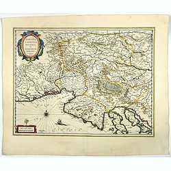
Karstia, Camiola, Histria et Windorum Marchia.
Map by Willem Blaeu, including the Gulf of Trieste, Venice and the northern part of former Yugoslavia. Prepared by Gerard Mercator.With the signature of Willem Blaeu in l...
Date: Amsterdam, 1644
Selling price: ????
Please login to see price!
Sold in 2022
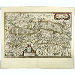
Austria Archiducatus.
Originally engraved for Jodocus Hondius II, at his death in August 1629 this map was, among 39 other copper plates,purchased by Willem Blaeu who deleted Hondius' name and...
Date: Amsterdam, 1644
Selling price: ????
Please login to see price!
Sold in 2017
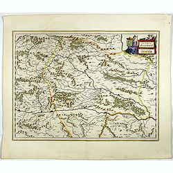
Stiria Steyermarck.
Map showing the Danube and its cities. Bordering Bohemia, Moravia, Saltsburg, Carinthia and Styria.More about Willem Blaeu. [+]
Date: Amsterdam, 1644
Selling price: ????
Please login to see price!
Sold in 2018
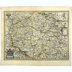
Bohemia.
Fine and early map of Czechoslovakia after Johann Criginger and used by Blaeu and others.As Willem Blaeu died in 1638 most of his maps are actually published by his son J...
Date: Amsterdam, 1644
Selling price: ????
Please login to see price!
Sold in 2021
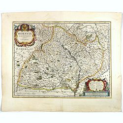
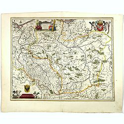
Moravia Marchionatus Auctore I.A. Comenio.
Attractive map of the historic Moravia region of the Czech Republic roughly centered on the city of Olomouc (Olmutz). Finely engraved with mountains, forests and even the...
Date: Amsterdam, 1644
Selling price: ????
Please login to see price!
Sold in 2019
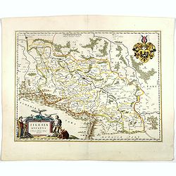
Silesia Ducatus . . .
Map centered on Breslau.As Willem Blaeu died in 1638 most of his maps are actually published by his son Joan.More about Willem Blaeu. [+]
Date: Amsterdam, 1644
Selling price: ????
Please login to see price!
Sold
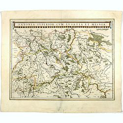
Saxonia Superior, cum Lusatia et Misnia.
Finely engraved and detailed map of Saxony including Halle, Leipzig, Meissen, and Dresden. Filled with forests and tiny villages. It presents Prague close to the center o...
Date: Amsterdam, 1644
Selling price: ????
Please login to see price!
Sold in 2017
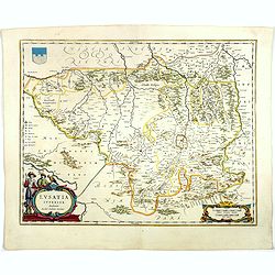
Lusatia Superior.
Attractive map of the region straddling present-day southwestern Poland, Saxony and the Czech Republic.Old city names including Lieba, Gorlitz, Dresden, Pirnaw, and Prybu...
Date: Amsterdam, 1644
Selling price: ????
Please login to see price!
Sold in 2023
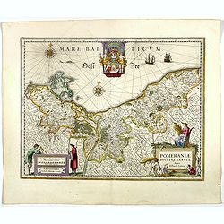
Pomeraniae ducatus Tabula.
Finely engraved map of Pomerania, geographical region today divided between northern Poland and Germany on the south coasts of the Baltic Sea. With decorative title carto...
Date: Amsterdam, 1644
Selling price: ????
Please login to see price!
Sold in 2017
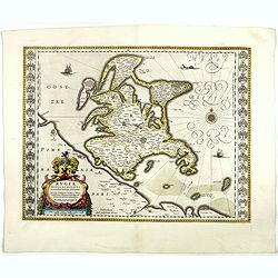
Rugia Insula ac ducatus..
Willem Blaeu's highly decorative map of the island of Rugen. Embellished with a title-cartouches, and 30 coats-of-arms in the borders. From the Latin edition of Willem Bl...
Date: Amsterdam, 1644
Selling price: ????
Please login to see price!
Sold in 2017
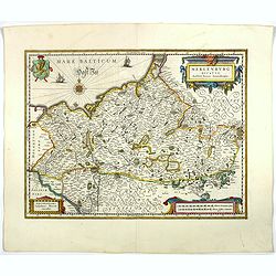
Meklenburg Ducatus.
Finely engraved map with a very decorative title cartouche adorned with a chain of fruits. A ship is sailing on the Baltic near a wind rose. In the left-hand upper part, ...
Date: Amsterdam, 1644
Selling price: ????
Please login to see price!
Sold in 2020
Ducatus Holsatiae nova tabula.
Finely engraved map centered on the area north of Hamburg and Lubeck with two insets.This is a second state of a map initially made by Jodocus Hondius.More about Willem B...
Date: Amsterdam, 1644
Selling price: ????
Please login to see price!
Sold in 2017
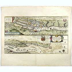
Celeberrimi Fluvis Albis nova delineatio.
Beautiful map of the river Elbe and Hamburg. Latin text on verso.Originally engraved for Jodocus Hondius, at his death on August 18, 1629, this among 39 other Hondius cop...
Date: Amsterdam, 1644
Selling price: ????
Please login to see price!
Sold in 2017
Osnabrugensis episcopatus.
A beautiful map of Munster centred on the city of Osnabruck. Prepared by Joannes Michael Gigas (1580-1650+), a doctor, mathematician and geographer. Showing an inset with...
Date: Amsterdam, 1644
Selling price: ????
Please login to see price!
Sold in 2018
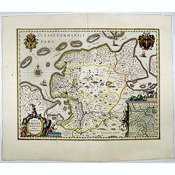
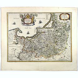
Typus Frisiae Orientalis.
Finely engraved map of east Frisia in Germany with the Watten islands. With inset map of the area south of Emden. Prepared by Ubbo Emmius (1547-1625). A very decorative t...
Date: Amsterdam, 1644
Selling price: ????
Please login to see price!
Sold in 2017
Clivia Ducatus et Ravestein Dominium.
A very decorative map with broad margins, showing a.o. the towns of Nijmegen, Venlo, Moers and Emmerich.More about maps by Willem Blaeu. [+]
Date: Amsterdam, 1644
Selling price: ????
Please login to see price!
Sold in 2017
Juliacensis et Montensis Ducatus/ De Hertoghdomen Gulick. . .
Map of the area to both sides of the Rhine between Bonn and Wesel, centered on Düsseldorf and reaching to Maastricht in the west and Altena/Westfalen in the east.Decorat...
Date: Amsterdam, 1644
Selling price: ????
Please login to see price!
Sold in 2019
Helvetia cum finitimis regionibus confoederatis.
Detailed and finely engraved map of Switzerland with a pair of fine cartouches.From early on Willem Jansz. Blaeu aimed of publishing an atlas to compete with the Hondius-...
Date: Amsterdam, 1644
Selling price: ????
Please login to see price!
Sold in 2020