Browse Listings
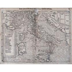
Italia mit dreien fürnemsten Inseln / Corsika / Sardinia und Sicilia.
An early woodcut map from a German edition of Münster's famous 'Cosmographie.' Shows the area from Marseille to Albania, including the Adriatic Sea, the islands of Sicil...
Date: Basel, ca. 1600
Selling price: ????
Please login to see price!
Sold in 2016
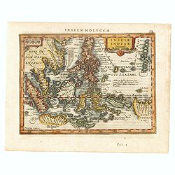
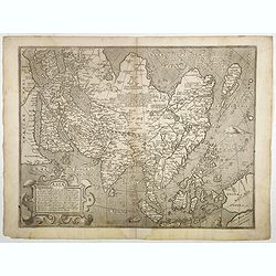
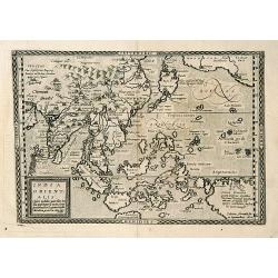
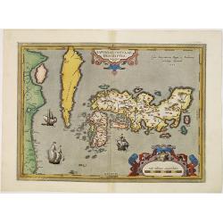
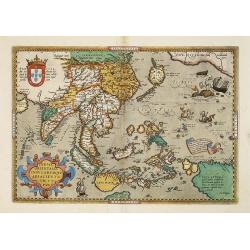
Insulae Indiae Orientalis.
One of the most decorative maps of the Indonesian Archipelago, including the Philippines, Malaya and further India. Signed in the plate bottom left, P. Kaerius Calavit.Re...
Date: Amsterdam, c.1600
Selling price: ????
Please login to see price!
Sold in 2016
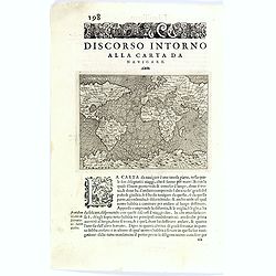
Discorso intorno alla carta da navigare.
An early edition of Porcacchi's mariner's map, which follows Gerard Mercator's large world map of 1569 on a much reduced scale.
Date: Venise, ca 1600
Selling price: ????
Please login to see price!
Sold in 2016
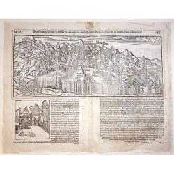
Jerusalem.
A beautiful double page woodcut bird's eye view of Jerusalem from Sebastian Münster's famous "Cosmographia", from the rare 1600 German edition. The view shows ...
Date: Basle, 1600
Selling price: ????
Please login to see price!
Sold in 2017
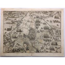
RynBerk (Seige of Rynberk).
This is a very detailed copper engraving with hundreds of identifiable soldiers, horses, fortresses and topographical places. It includes ships in the rivers.The Siege of...
Date: Amsterdam, 1600
Selling price: ????
Please login to see price!
Sold in 2021
Asia..
Very rare map of Asia executed by the Flemish artist and cartographer Fiamengo Arnoldo di Arnoldi, who was working in Bologna and Siena, at the end of the 16th century.Be...
Date: Siena, 1600
Selling price: ????
Please login to see price!
Sold
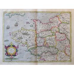
Britannia & Normandia cum confinibs regionibus.
An important early map of Bretagne (Brittany) and Normandie, extending to show Paris, the Channel Islands, and parts of Cornwall. Decorated with sailing ships, a sea mons...
Date: Duisburg or Amsterdam, ca. 1600
Selling price: ????
Please login to see price!
Sold in 2017
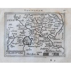
Oropitum.
A lovely, detailed miniature map of the region around the Lago di Bolsena, including the cities of Montefiascone, Viterbo, Orvieto, and many more.
Date: Antwerp, ca. 1600
Selling price: ????
Please login to see price!
Sold in 2017
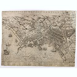
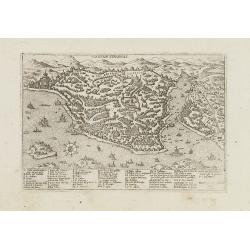
La Citta di Napoli Gentile.
Florimi's plan of the city of Naples derives from Mario Cartaro's plan (1579). Probably engraved by Arnoldo di Arnoldi (Arnold van Scherpenseel) who worked for a short ti...
Date: Siena, c. 1600
Selling price: ????
Please login to see price!
Sold
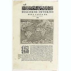
Discorso intorno alla carta da navigare.
An early edition of Porcacchi's mariner's map, which follows Gerard Mercator's large world map of 1569 on a much reduced scale. From "L'Isole piu Famose del Mondo&qu...
Date: Venise, ca 1600
Selling price: ????
Please login to see price!
Sold in 2020
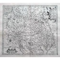
France Picardie Champaigne cum regionibus adiacentibus.
An early map of Bretagne (Brittany), Normandie, and Champagne. Extends from Arras to Auxerre and Orleans. Including Dieppe, Rouen, Paris, Verdun, towns are shown as small...
Date: Amsterdam, ca 1600
Selling price: ????
Please login to see price!
Sold in 2018
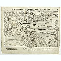
Europa primi pars terrae in forma Virginis septentrio.
Desirable, famous, and relatively scarce-to-rare items are usually deemed a curiosity or oddity map. All of Europe is depicted as a Queen wearing her crown and flowing ro...
Date: Magdeburg, ca 1581-1600
Selling price: ????
Please login to see price!
Sold
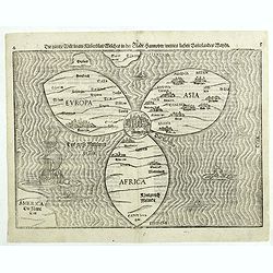
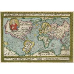
Die gantze Welt in ein Kleberblatt. . .
This extraordinary curiosity is referred to as the Clover-leaf, for obvious reasons. Heinrich Bünting's design was inspired by the trefoil form of the arms of Hanover, h...
Date: Magdeburg, 1581-1600
Selling price: ????
Please login to see price!
Sold in 2018
Riga.
An early view of Riga from the seaside with many buildings shown. Set on a page with latin text printed on both sides. Published in Münsters famous "Cosmographie&qu...
Date: Basel, ca 1600
Selling price: ????
Please login to see price!
Sold in 2018
![[set of 4] Terra; Aer; Ignis; Aqua;](/uploads/cache/82269-250x250.jpg)
[set of 4] Terra; Aer; Ignis; Aqua;
Very rare set of engravings illustrating the Four Elements. Published in Paris by Thomas de Leu after Johan Sadeler and Maarten de Vos. Thomas de Leu (or Leeuw, 1560-1612...
Date: Paris, ca. 1600
Selling price: ????
Please login to see price!
Sold in 2019
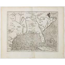
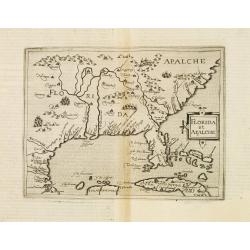
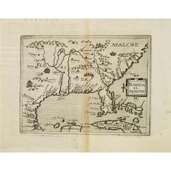
Florida et Apalche.
Wyfliet's map is one of the earliest to focus on the Southeast and to name "Florida", showing part of Texas, Mexico, Cuba, the Bahamas and the Gulf of Mexico.Dr...
Date: Louvain, 1597-1600
Selling price: ????
Please login to see price!
Sold in 2020
![Der Orietalischen Idien. . . [Title page]](/uploads/cache/43483-250x250.jpg)
Der Orietalischen Idien. . . [Title page]
A very attractive title page from the second part of de Bry's travel book. Theodore de Bry, a German engraver and book dealer, began a compilation of early voyages in 159...
Date: Frankfurt, 1600
Selling price: ????
Please login to see price!
Sold in 2020
![Stocholmia [Stockholm].](/uploads/cache/44040-250x250.jpg)
Stocholmia [Stockholm].
The top engraving, showing the timber houses so typical of Scandinavia, is a view from the northeast across what was then the suburb of Norrmalm and is now the city centr...
Date: Cologne, 1588-1600
Selling price: ????
Please login to see price!
Sold in 2020
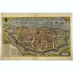
Antverpia.
A spectacular bird's-eye view plan of Antwerp by Braun and Hogenberg after Georg Hoefnagel, with key to locations. From the famous Civitates Orbis Terrarum.COMMENTARY BY ...
Date: Cologne, ca 1600
Selling price: ????
Please login to see price!
Sold in 2020
India Orientalis.
Matthäus Quad's uncommon map depicts most of the Asian continent stretching northward to encompass Japan and eastward to show the coast of North America and New Guinea. ...
Date: Cologne 1600
Selling price: ????
Please login to see price!
Sold
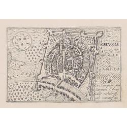
Grenoble.
Uncommon plan of Grenoble from Francesco Valegio's townbook: Raccolta di le piv illustri et farmose citta di tutto il mondo.
Date: Venice 1600
Selling price: ????
Please login to see price!
Sold
![[Zurichgow et Basiliensis Provincia].](/uploads/cache/14324-250x250.jpg)
[Zurichgow et Basiliensis Provincia].
Including the towns of Basle, Lucerne, Zürich, etc.Mercator was born in Rupelmonde in Flanders and studied in Louvain under Gemma Frisius, Dutch writer, astronom...
Date: Amsterdam c.1600
Selling price: ????
Please login to see price!
Sold
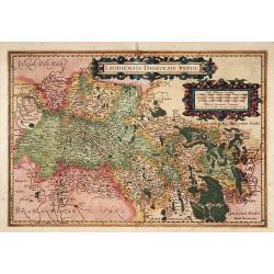
Leodiensis Dioecesis Typus.
Engraved by Baptist Doetecum. East to the top. Showing the River Maas up to Roermond.
Date: Amsterdam, 1600
Selling price: ????
Please login to see price!
Sold in 2015
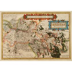
Leodiensis Dioecesis Typus.
Engraved by Baptist Doetecum. East to the top. Showing the River Maas up to Roermond.
Date: Amsterdam, 1600
Selling price: ????
Please login to see price!
Sold in 2018
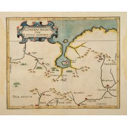
Conibas Regio cum uicinis gentibus.
2nd State. The first printed map of present day central Canada issued by Cornelis van Wytfliet in editions of his Descriptionis Ptolemaicae Augmentum first published in L...
Date: Lovain 1597-1600
Selling price: ????
Please login to see price!
Sold
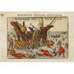
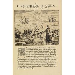
Baixos de India.
Early print of a wreaked ship, with people captured by giant lobsters! From the Caert-Thresoor and engraved by the Dutch master-engraver Petrus Kaerius. The first edition...
Date: Amsterdam 1600
Selling price: ????
Please login to see price!
Sold
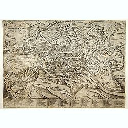
Novissima Urbis Romae Descriptio.
A rare view of Rome from the Lafreri-School.
Date: Sienne, 1600
Selling price: ????
Please login to see price!
Sold
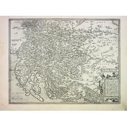
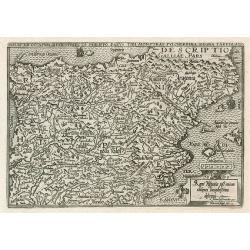
Illyricum
Detailed early map of Istria, Slovenia and parts of Croatia. Skillfully engraved towns, mountains, woods and rivers! First issued 1572 by Johannes Sambucus, this is the 2...
Date: Antwerp. c1600
Selling price: ????
Please login to see price!
Sold
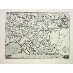
Schlavoniae, Croatiae, Carniae, Istriae, Bosniae...
Detailed early map after Hirschvogel of Southern Austria, Slovenia, Croatia, Bosnia and a small part of Italy. Artfully engraved map with many place names, showing towns,...
Date: Antwerp, c1600
Selling price: ????
Please login to see price!
Sold
Florida et Apalache.
Very rare map of Florida, including parts of Cuba and the east coast north to the area of the Outer Banks of Carolina. The map is a reduced version of Cornelis Wytfliet m...
Date: Cologne 1600
Selling price: ????
Please login to see price!
Sold
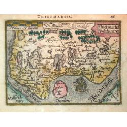
Thietmarsiae Holsaticaereg.
Petrus Bertius (1565- Paris,1629), Dutch cartographer and engraver. Pocket atlas ' Tabularum geographicarum contractarum', 1600-16, ' Totius orbis Terrarum', 1626. Worked...
Date: Amsterdam, c. 1600
Selling price: ????
Please login to see price!
Sold
![Facies astrolabij particularis I - IX. [Nine sheets]](/uploads/cache/21692-250x250.jpg)
Facies astrolabij particularis I - IX. [Nine sheets]
An extremely rare set of nine sheets to be meant as book illustrations. Each of them showing the different parts for the construction of an astrolabe. The map of the worl...
Date: Germany ca. 1600
Selling price: ????
Please login to see price!
Sold
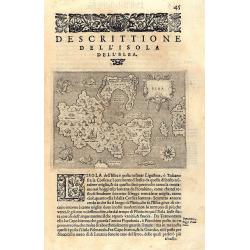
DESCRITTIONE DELL\'ISOLA DELL\'ELBA
Rare early map of Elba of the Tuscany coast. Beautifully engraved with pictoral symbols for the towns and decorated with seamonsters, ships, a mermaid, a compassrose and ...
Date: Padua c.1600
Selling price: ????
Please login to see price!
Sold in 2010
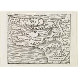
Africa.
A woodcut map of the African continent from a French edition of Cosmographia by Sebastian Münster. The map shows most of Africa including the supposed source of the Nile...
Date: Basle 1600
Selling price: ????
Please login to see price!
Sold
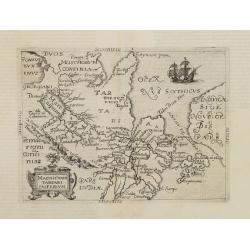
Magni Chami Tartari Imperium.
Included in German edition of José de Acosta's De Natura Nova Orbis . Acosta was a Spanish Jesuit missionary, historian and cosmographer.Scarce. Including the north west...
Date: Cologne 1600
Selling price: ????
Please login to see price!
Sold

Abraham Ortelius.
Date: Antwerp, c.1600
Selling price: ????
Please login to see price!
Sold
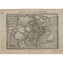
Abiffinorum Imperium
After A. Ortelius.
Date: Antwerp, c. 1600
Selling price: ????
Please login to see price!
Sold
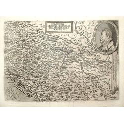
Sclavonia Croatia, Bosnia & Dalmatiae Pars Maior.
Matthias Quadt (1557-1613), Dutch geographer, worked in Cologne. ' Europae', 1592, 'Geographisch handtbuch, 1600 and Fasciculus Geographicus'. Johan Bussemacher published...
Date: Cologne, 1600
Selling price: ????
Please login to see price!
Sold in 2018
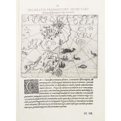
II. Delineatio Promontorii, qvod Cabo de bona Esperanca vulgo vocatur.
One of the earliest map of Cape of Good Hope region.
Date: Frankfurt 1600
Selling price: ????
Please login to see price!
Sold
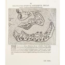
XI. Delineatio Duorum Oppidorum, Ortattani & Londorae in Banda Insula sitorum.
Earliest map of Banda islands. Copper engraving with letter press.
Date: Frankfurt 1600
Selling price: ????
Please login to see price!
Sold
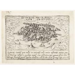
Quinzai.
Uncommon plan of Quinzai (in China) with its bridges from Francesco Valegio's townbook: Raccolta di le piv illustri et farmose citta di tutto il mondo.
Date: Venice 1600
Selling price: ????
Please login to see price!
Sold
Florida et Apalche.
Very rare map of Florida, including parts of Cuba and the east coast north to the area of the Outer Banks of Carolina. The map is a reduced version of Cornelis Wytfliet m...
Date: Cologne, 1600
Selling price: ????
Please login to see price!
Sold in 2013
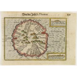
Ins. Sti. Thome
Early miniature map of Saint Thomas from the Caert-Thresoor and engraved by the Dutch master-engraver Petrus Kaerius. The first edition was printed in Middelburg by Baren...
Date: Amsterdam, 1600
Selling price: ????
Please login to see price!
Sold in 2008
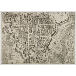
![Quinzai. [Hangzhou]](/uploads/cache/25263-250x250.jpg)
Quinzai. [Hangzhou]
Uncommon and one of the earliest western prints, showing a bird's eye view of Hangzhou. From Francesco Valegio's townbook: Raccolta di le piv illustri et farmose citta di...
Date: Venice, 1600
Selling price: ????
Please login to see price!
Sold in 2008
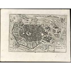
Wratislavia silesie metropolis ad Odra et olaue Fluuiorum con fluentern sita est
Beautiful and detailed birdeye view of Wroclaw in Silesia, Poland. Signed in the plate by Francesco Valegio. Printed in Venice around 1600.
Date: Venice, 1600
Selling price: ????
Please login to see price!
Sold in 2008
Citta dell\' Aqulia.
Rare and early plan of L\'Aquila in central Italy.Published by Jacobus Laurus.Rare, separately published, "Lafreri" map.
Date: Rome, 1600
Selling price: ????
Please login to see price!
Sold in 2008
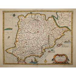
Tab. II. Europae, Hispaniam ac Lusitaniam Complectens
An attractive Ptolemaic map of the Iberian Peninsula. Mercator originally published this map in his 1578 edition of Ptolemy's great Geography.
Date: c.1600
Selling price: ????
Please login to see price!
Sold in 2009
Typus Orbis Terrarum..
Early worldmap, from: Geographisch Handtbuch. Cologne, Engraved by J. Bussemacher, reduced from Mercator's planispherical map of 1596, with the addition of the figure of ...
Date: Cologne, 1600
Selling price: ????
Please login to see price!
Sold in 2010
Regni Hispaniae post omium editiones locupletissima descriptio.
Spain by Quad. Rare.
Date: Coln, 1600
Selling price: ????
Please login to see price!
Sold in 2009
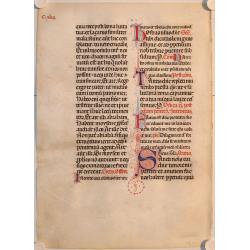
Leaf from a manuscript antiphonal on vellum.
A fine sheet of thin vellum written in black and red ink with several large initials in delicate red and blue penwork.
Date: ca. 1600
Selling price: ????
Please login to see price!
Sold in 2009
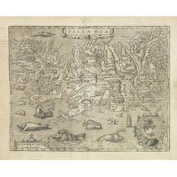
Islandia.
Quad's : reduced in size Ortelius´ map, of Iceland. With German text on verso, from Geographisch Handtbuch. Signed by the engraver Johan Bussemacher.Rare in original col...
Date: Cologne, 1600
Selling price: ????
Please login to see price!
Sold in 2016
Constantinopoli.
Uncommon plan of Istanbul from Francesco Valegio's townbook: "Raccolta di le piv illustri et farmose citta di tutto il mondo".
Date: Venice, 1600
Selling price: ????
Please login to see price!
Sold in 2009
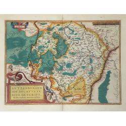
Lutzenburgensis Ducatus Veriss Descript.
Map of the Luxembourg published by Ortelius, manuscript map prepared by Jacob Surhon. Surhon was paid 500 Livres for the manuscript map by Charles V in 1551. The map was ...
Date: Antwerp, c. 1600
Selling price: ????
Please login to see price!
Sold in 2010
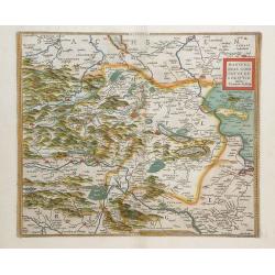
Mansfeldiae Comitatus Descriptioauctore Tilemanno Stella Sig.
Map of the region surrounding the town of Mansfeld (Mansfelt) in central Germany. The manuscript map drawn by Tilemann Stella. Mansfeld is the town that Martin Luther gre...
Date: Antwerp, c. 1600
Selling price: ????
Please login to see price!
Sold in 2010
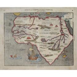
AFRICA TERTIA PARS TERRÆ .
This map is one of the later woodcut maps of Africa. As such, the appearance of the map, especially when compared to other maps from this period, is unusual. Like Bünt...
Date: Magdeburg, (1589) 1600
Selling price: ????
Please login to see price!
Sold in 2013
IAPONIAE INSULAE DESCRIPTIO. Ludoico Teisera auctore.
RARE in this perfect condition. The map was based upon the manuscript draft supplied to Ortelius in about 1592 by the famous official Portuguese chart maker, Luis Teixeir...
Date: Antwerp, 1601
Selling price: ????
Please login to see price!
Sold in 2017
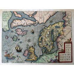
Septentrionalium Regionum Descrip.
A fantastic map of the northern Atlantic. Shows a part of America, Greenland, Iceland, the British Islands, Scandinavia, and parts of Europe and Russia. With several phan...
Date: Antwerp, 1601
Selling price: ????
Please login to see price!
Sold in 2016
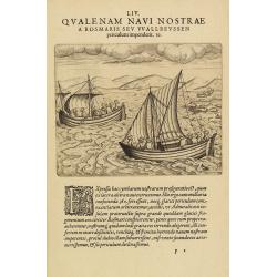
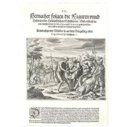
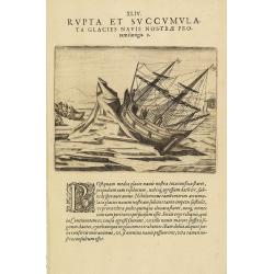
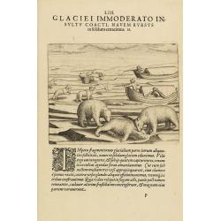
LIV Qualenam navi nostrae a rosmaris seu Wallreussen periculum impenderit 19. (The third Dutch artic voyage by W.Barentsz.)
These famous and desirable scene is engraved by de Bry depicting the two open ships during the return voyage during the third Dutch arctic voyage in order to find the nor...
Date: Frankfurt 1601
Selling price: ????
Please login to see price!
Sold in 2014
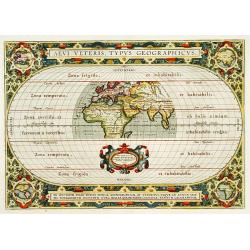
Aevi Veteris, Typus geographicus.
Ancient world map depicting the area of the earth known in classic times. The map occupies the central section of a larger oval projection and extends as far east as Suma...
Date: Antwerp 1601
Selling price: ????
Please login to see price!
Sold
The inhabitants of the Cape of Good Hope
This is the first print to show the inhabitants of the Cape together with Europeans, and one of the first large scale prints of the native peoples of the Cape..The plate ...
Date: Frankfurt 1601
Selling price: ????
Please login to see price!
Sold
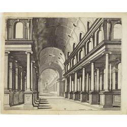
Perspective print after Vredeman de Vries.
Engraving after Hans, or Johannes Vredeman de Vries (ca.1527-1604), a famous Dutch architect and draughtsman, known in the Low Countries as "The king of architects&q...
Date: Antwerp, c. 1562 - 1601
Selling price: ????
Please login to see price!
Sold in 2016
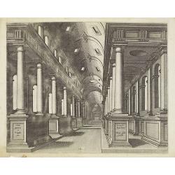
Perspective print after Vredeman de Vries.
Engraving after Hans, or Johannes Vredeman de Vries (ca.1527-1604), a famous Dutch architect and draughtsman, known in the Low Countries as 'The king of architects'. Born...
Date: Antwerp, c. 1562 - 1601
Selling price: ????
Please login to see price!
Sold in 2020
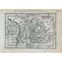
Ducatus mediolanensis, ?
Miniature map of a part of Italy, with major cities named. Strapwork title cartouche. Latin text on verso.
Date: Antwerp, 1601
Selling price: ????
Please login to see price!
Sold in 2010
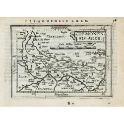
Ceremonensis Ager.
Miniature map of a part of Italy, with major cities named. Strapwork title cartouche. Latin text on verso
Date: Antwerp, 1601
Selling price: ????
Please login to see price!
Sold in 2010
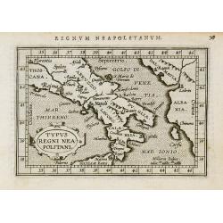
Typus regni Neapolitani.
Miniature map of a part of Italy, with major cities named. Strapwork title cartouche. Latin text on verso.
Date: Antwerp, 1601
Selling price: ????
Please login to see price!
Sold in 2010
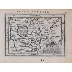
Perusia.
Miniature map of a part of Italy, with major cities named. Strapwork title cartouche. Latin text on verso.
Date: Antwerp, 1601
Selling price: ????
Please login to see price!
Sold in 2010
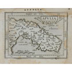
Apulia.
Miniature map of a part of Italy, with major cities named. Strapwork title cartouche. Latin text on verso.
Date: Antwerp, 1601
Selling price: ????
Please login to see price!
Sold in 2010
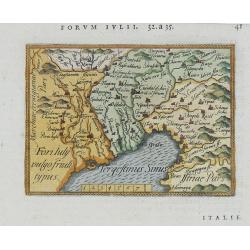
Fori Iuly vulgo Friuli typus.
Miniature map of a part of Italy, with major cities named. Strapwork title cartouche. Latin text on verso.
Date: Antwerp, 1601
Selling price: ????
Please login to see price!
Sold in 2010
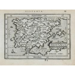
Hispania.
Miniature map of a part of Spain and Portugal, with major cities named. Strapwork title cartouche. Latin text on verso.
Date: Antwerp, 1601
Selling price: ????
Please login to see price!
Sold in 2010
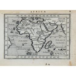
Africa.
Miniature map of Africa. Strapwork title cartouche. Latin text on verso.
Date: Antwerp, 1601
Selling price: ????
Please login to see price!
Sold in 2010
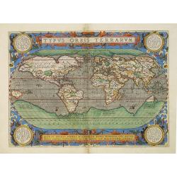
Typus Orbis Terrarum.
Ortelius' third and last world map is dated 1587 under the author's signature. The earlier border of clouds has been replaced by a more intricate and elegant lattice of s...
Date: Antwerp, 1601
Selling price: ????
Please login to see price!
Sold in 2010
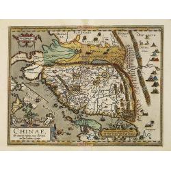
Chinae, olim Sinarum Regionis, nova descriptio. Auctore Ludovico Georgio.
The first map of China ever to appear in a Western atlas, west to the top. When this map appeared, it was by far the most accurate one of China.Japan is shown on a curiou...
Date: Antwerp, 1601
Selling price: ????
Please login to see price!
Sold in 2010
Russiae, Moscoviae et Tartariae Descriptio.
Engraved by Frans Hogenberg from an original of 1562 by Anthony Jenkinson of the English Muscovy Company. The map covers the region from the Gulf of Finland, Lithuania an...
Date: Antwerp, 1601
Selling price: ????
Please login to see price!
Sold in 2010
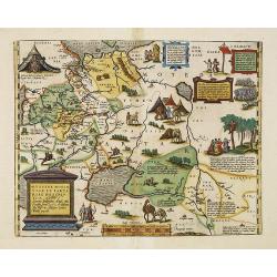
Indiae Orientalis, Insularumque Adiacientium Typus.
Finely originally hand colored example of Ortelius' map of SE Asia, Japan, and the Philippines, etc. The map includes Beach and other information drawn from Marco Polo.Th...
Date: Antwerp, 1601
Selling price: ????
Please login to see price!
Sold in 2010
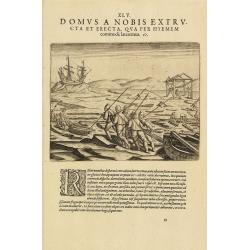
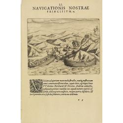
The third Dutch artic voyage by W.Barentsz.
Scene during the third Dutch arctic voyage in order to find the north-east passage to India.Barentsz made three voyages (1594, 1595, 1596-1597) in search of the Northeast...
Date: Frankfurt, 1601
Selling price: ????
Please login to see price!
Sold in 2016
The third Dutch artic voyage by W.Barentsz.
Desirable scene during the third Dutch arctic voyage in order to find the north-east passage to India.Barentsz made three voyages (1594, 1595, 1596-1597) in search of the...
Date: Frankfurt, 1601
Selling price: ????
Please login to see price!
Sold
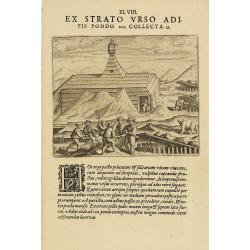
The third Dutch artic voyage by W.Barentsz.
This famous and desirable scene showing the "Behouden Huys" during the third Dutch arctic voyage in order to find the north-east passage to India.Barentsz made ...
Date: Frankfurt, 1601
Selling price: ????
Please login to see price!
Sold in 2010
The third Dutch artic voyage by W.Barentsz.
Desirable scene during the third Dutch arctic voyage in order to find the north-east passage to India.Barentsz made three voyages (1594, 1595, 1596-1597) in search of the...
Date: Frankfurt, 1601
Selling price: ????
Please login to see price!
Sold
The third Dutch artic voyage by W.Barentsz.
Desirable scene during the third Dutch arctic voyage in order to find the north-east passage to India.Barentsz made three voyages (1594, 1595, 1596-1597) in search of the...
Date: Frankfurt, 1601
Selling price: ????
Please login to see price!
Sold
The third Dutch artic voyage by W.Barentsz.
Desirable scene during the third Dutch arctic voyage in order to find the north-east passage to India.Barentsz made three voyages (1594, 1595, 1596-1597) in search of the...
Date: Frankfurt, 1601
Selling price: ????
Please login to see price!
Sold