Browse Listings
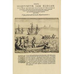
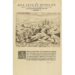
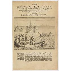
The third Dutch artic voyage by W.Barentsz.
Depicting a scene during the third Dutch arctic voyage in order to find the north-east passage to India.Barentsz made three voyages (1594, 1595, 1596-1597) in search of t...
Date: Frankfurt, 1601
Selling price: ????
Please login to see price!
Sold
The third Dutch artic voyage by W.Barentsz.
This desirable scene during the third Dutch arctic voyage in order to find the north-east passage to India.Barentsz made three voyages (1594, 1595, 1596-1597) in search o...
Date: Frankfurt, 1601
Selling price: ????
Please login to see price!
Sold in 2017
The third Dutch artic voyage by W.Barentsz.
This desirable scene during the third Dutch arctic voyage in order to find the north-east passage to India.Barentsz made three voyages (1594, 1595, 1596-1597) in search o...
Date: Frankfurt, 1601
Selling price: ????
Please login to see price!
Sold in 2017
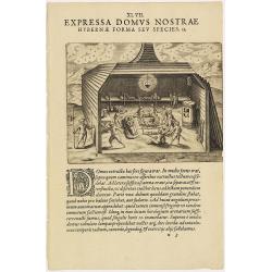
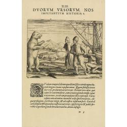
The third Dutch artic voyage by W.Barentsz.
This famous and desirable scene of the interior of "Het Behouden Huys", during the third Dutch arctic voyage in order to find the north-east passage to India.Ba...
Date: Frankfurt, 1601
Selling price: ????
Please login to see price!
Sold
The third Dutch artic voyage by W.Barentsz.
This famous and desirable scene during the third Dutch arctic voyage in order to find the north-east passage to India.Barentsz made three voyages (1594, 1595, 1596-1597) ...
Date: Frankfurt, 1601
Selling price: ????
Please login to see price!
Sold in 2017
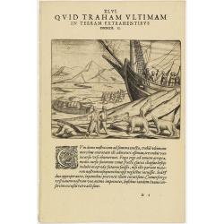
The third Dutch artic voyage by W.Barentsz.
This famous and desirable scene during the third Dutch arctic voyage to find the northeast passage to India.Barentsz made three voyages (1594, 1595, 1596-1597) searching ...
Date: Frankfurt, 1601
Selling price: ????
Please login to see price!
Sold in 2017
The third Dutch artic voyage by W.Barentsz.
This famous and desirable scene is depicting a scene during the third Dutch arctic voyage in order to find the north-east passage to India.Barentsz made three voyages (15...
Date: Frankfurt, 1601
Selling price: ????
Please login to see price!
Sold in 2010
The third Dutch artic voyage by W.Barentsz.
A desirable scene during the third Dutch arctic voyage in order to find the north-east passage to India.Barentsz made three voyages (1594, 1595, 1596-1597) in search of t...
Date: Frankfurt, 1601
Selling price: ????
Please login to see price!
Sold
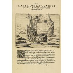
The third Dutch artic voyage by W.Barentsz.
These famous and desirable scene is engraved by de Bry depicting a scene during the third Dutch arctic voyage in order to find the north-east passage to India.Despite the...
Date: Frankfurt, 1601
Selling price: ????
Please login to see price!
Sold in 2017
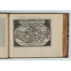
Epitome Theatri Orteliani, praecipuarum orbis regionum delineationes...
Latin pocket-size atlas of Ortelius' "Theatrum Orbis Terrarum", published for those who could not afford the expensive large atlases of the time. "A new se...
Date: Antwerp J.B., Vrients, 1601
Selling price: ????
Please login to see price!
Sold in 2020
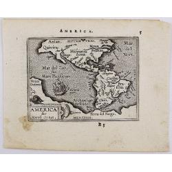
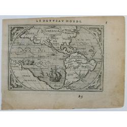
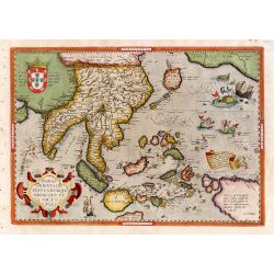
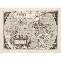
America sive Novus Orbis.
The miniature map of North and South America based on Ortelius' larger map, ornamented with sailing ship. It comes from Latin edition of pocket-size atlas "Epitome T...
Date: Antwerp, 1601
Selling price: ????
Please login to see price!
Sold in 2020
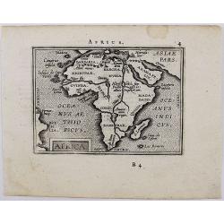
Africa.
The miniature map of Africa based on Ortelius' larger map. It comes from the Latin edition of pocket-size atlas "Epitome Theatri Orteliani" engraved by Philip G...
Date: Antwerp, 1601
Selling price: ????
Please login to see price!
Sold in 2020
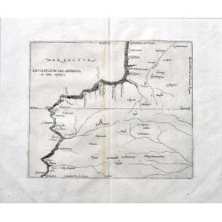
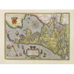
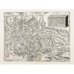
Descripcion del audencia 10 del Quito.
A rare early map with parts of modern day Ecuador, Columbia and Peru. Naming towns, and showing rivers. The earliest map to include information from the previously secret...
Date: Madrid, ca 1601
Selling price: ????
Please login to see price!
Sold in 2022
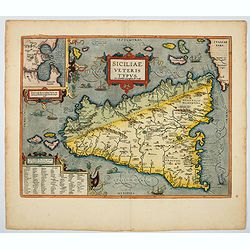
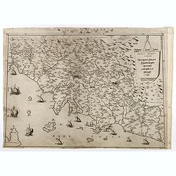
Siciliae Veteris Typus.
A very beautiful early map of ancient Sicily. Title cartouche centered on the upper part: includes an inset map of the ancient city of Syracuse, a city notable for its ri...
Date: Antwerp, 1601
Selling price: ????
Please login to see price!
Sold in 2021
Descripcion De Las Indias Del Poniente 14.
Plate 14 from Herrera’s Descripción de las Indias Occidentales.The work is based on the manuscript charts of Juan Lopez de Velasco dating from approximately 1...
Date: Madrid, 1601
Selling price: ????
Please login to see price!
Sold in 2012
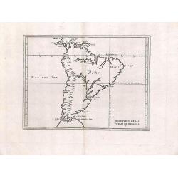
Descripcion de las yndias de mediodia.
Rare map depicting South America by Antonio de Herrera Y Tordesillas. He was the official historian of Spain and the Indies. This simply engraved map of the continent was...
Date: 1601
Selling price: ????
Please login to see price!
Sold in 2013
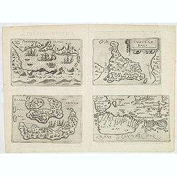
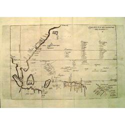
Amboinum Insula / Insulae Baly / Banda Insula / Java mayor.
Four maps on one sheet, extremely rare maps of Ambon, Banda, Bali and Java, included in Johannes Metelellus, Insularium Orbis Aliquot insularum tabulis Aeneis delineation...
Date: Cologne, 1601
Selling price: ????
Please login to see price!
Sold in 2019
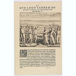
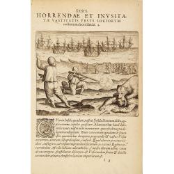
LV. Quo loco tandem homines iterum in conspectum nobis dati sint 20. (The third Dutch artic voyage by W.Barentsz.)
Willem Barentsz encounter with Russian locals during the third Dutch arctic voyage in order to find the north-east passage to India.Barentsz made three voyages (1594, 159...
Date: Frankfurt, 1601
Selling price: ????
Please login to see price!
Sold in 2023
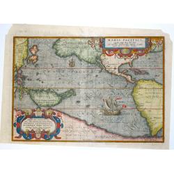
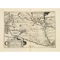
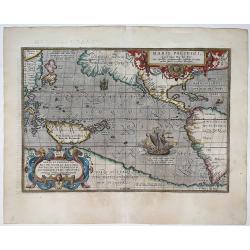
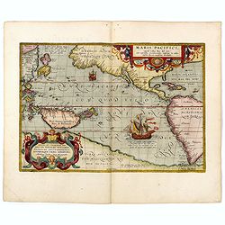
Maris Pacifici.
This was the first printed map to be devoted solely to the Pacific, and the first to name North and South America separately. It includes most of North and South America,...
Date: Antwerp, 1601
Selling price: ????
Please login to see price!
Sold in 2013
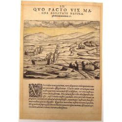
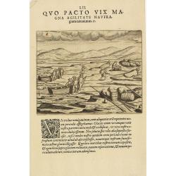
Quo Pacto vix Magna Agilitate Navfra (The Third Dutch Arctic Voyage).
Fine Copper Engraving of "The Third Dutch Arctic Voyage", engraved by W. Barentsz. This scene pictures one of Barentsz's voyages attempting to find a North-East...
Date: Frankfurt, 1601
Selling price: ????
Please login to see price!
Sold in 2015
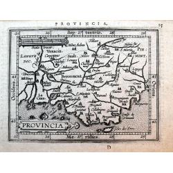
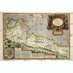
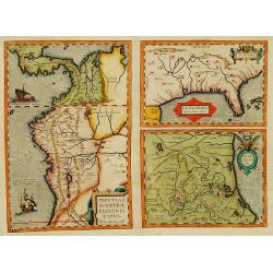
Provincia
Miniature map of Provence after Ortelius published by Giovanni Battista Vrients. Names the cities of Arles, Aix, Avignon, Marseille, Antibes, Toulon, and Nice. Decorated ...
Date: Antwerp, ca. 1601
Selling price: ????
Please login to see price!
Sold in 2016
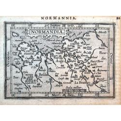
Normandia.
Miniature map of Normandy after Ortelius published by Giovanni Battista Vrients. Among many others it names the cities of Paris, Amiens, Dieppe, Caen, and Rouen. Decorate...
Date: Antwerp, ca. 1601
Selling price: ????
Please login to see price!
Sold in 2016
The third Dutch artic voyage by W.Barentsz.
These famous and desirable scene is engraved by de Bry depicting a scene during the third Dutch arctic voyage in order to find the north-east passage to India.Despite the...
Date: Frankfurt, 1601
Selling price: ????
Please login to see price!
Sold in 2018
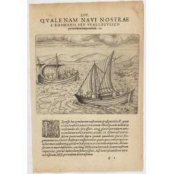
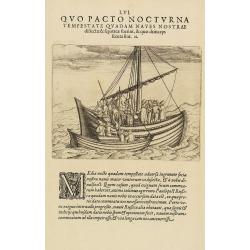
The third Dutch artic voyage by W.Barentsz.
These famous and desirable scene is engraved by de Bry, depicting the two open ships during the return voyage during the third Dutch Arctic voyage to find the north-east ...
Date: Frankfurt, 1601
Selling price: ????
Please login to see price!
Sold in 2022
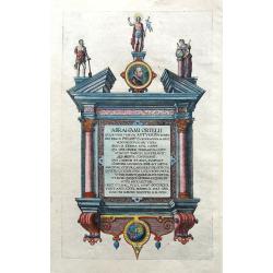
Abrahami Ortelli. . .
Decorative sheet with a portrait of the great Abraham Ortelius published after his death in 1598. Including a small map of Eastern Hemisphere. The text is the epitaph wri...
Date: Antwerp, ca. 1601
Selling price: ????
Please login to see price!
Sold in 2020
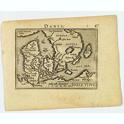
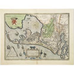
Daniae Typus.
A fine early map of Denmark and including southern Sweden by Abraham Ortelius, engraved in small format by J.B. Vrients. Latin text on verso.
Date: Antwerp, ca 1601
Selling price: ????
Please login to see price!
Sold in 2020
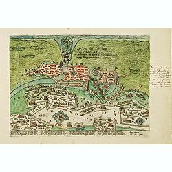
Die Stat und Vestung Kynsael.. Ihrlandt welchs vbr die dreissig Jahr der Cron England zu wider war. . .
Showing siege of Kinsale on 8 January 1602, when the Spanish forces surrender to the English. The Battle of Kinsale was a decisive turning point in Irish history, bringin...
Date: Cologne, 1602
Selling price: ????
Please login to see price!
Sold in 2012
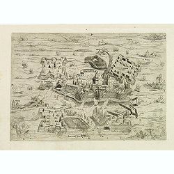
La Mirandola.
A rare and early town-plan with the siege of Mirandola. In the foreground Modena and in the background Mantua. To the left the French Royal flag as Mirandola had allied w...
Date: Rome, 1586 / 1602
Selling price: ????
Please login to see price!
Sold in 2012
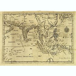
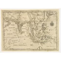
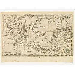
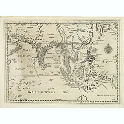
No title: South East Asia.
Very rare map of South East Asia, also including India, China, Japan and the northern tip of Australia , published by Hulsius.The German writer Levinus Hulsius compiled a...
Date: Nuremberg, 1602
Selling price: ????
Please login to see price!
Sold in 2012
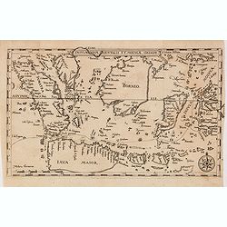
Insulae Indiae Orientalis et Molucae.
Very rare map of South East Asia, depicting Sumatra, Java, Borneo, Sulawesi, Moluccas, Bali, southern tip of Malaysia, mentioning "Siucapura" (Singapore), publi...
Date: Nuremberg, 1602
Selling price: ????
Please login to see price!
Sold in 2014
Western Hemisphere.
Scarce early miniature map of America from the 1602 Ortelius Epitome Theatri Orbis Terrarum. Virginia and California are named and spurious rivers in North America are sh...
Date: Antwerp, 1602
Selling price: ????
Please login to see price!
Sold in 2014
![[ South East Asia. ]](/uploads/cache/35256-250x250.jpg)
[ South East Asia. ]
Very rare map of South East Asia, also including India, China, Japan and the northern tip of Australia , published by Hulsius.The German writer Levinus Hulsius compiled a...
Date: Nuremberg, 1602
Selling price: ????
Please login to see price!
Sold in 2014
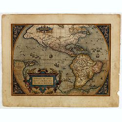
Americae sive novi orbis, nova descriptio.
In 1587, a new plate was engraved which appeared in editions from 1588 onwards. Of the three maps, this one is perhaps the most important. It is the most geographically a...
Date: Antwerp, 1602
Selling price: ????
Please login to see price!
Sold in 2015
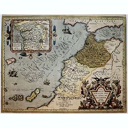
Fessae, et Marocchi Regna Africae Celeberr. describebat Abrah. Ortelius. 1595.
Uncommon map, covering north-western Africa, with the Canaries and Madeira. With an inset of the Congo, after Filippo Pigafetta's famous map of the kingdom.
Date: Antwerp, 1602
Selling price: ????
Please login to see price!
Sold in 2017
La Toscana.
Rare map of Tuscany reissued by Orlandi after Bell'Armato's Chorographia Tusciae. This map derives from Bell'Armato's Chorographia Tusciae. The present map was first issu...
Date: Rome, Giovanni Orlandi, 1602
Selling price: ????
Please login to see price!
Sold in 2017
![Atlas - Tabularum geographicorum contractum libri quinque. [with 148 maps]](/uploads/cache/43919-250x250.jpg)
Atlas - Tabularum geographicorum contractum libri quinque. [with 148 maps]
Uncommon French text edition, published by Christoffle Goyot, in Leiden for Cornelis Claes. The Caert-Thresoor of 1598 set a new standard for minor atlases. Scholars like...
Date: Leiden, Christoffle Goyot, 1602
Selling price: ????
Please login to see price!
Sold in 2019
Indiae Orientalis Insularemque.
Covering all of South East, China, Japan (Kyushu and Honshu shown as one peculiar circular-shaped Island) and the West Coast of North America. The Northern coasts of New ...
Date: Antwerp 1602
Selling price: ????
Please login to see price!
Sold
" Mürs Comitatus."
"Detailed and early map centred on Moers, Duisburg and Xanten. With two insets: ""Mürs Oppidum et Arx"" and ""Modiliana"&...
Date: Amsterdam 1602
Selling price: ????
Please login to see price!
Sold
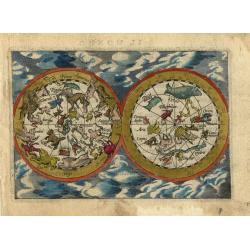
Untitled - Celestial Chart
This, scarce tiny celestial map presents the northern and southern skies with mythological representations of the constellations set in a cloud background. After the deat...
Date: Antwerp, 1602
Selling price: ????
Please login to see price!
Sold in 2008
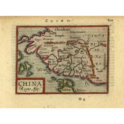
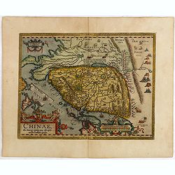
China, Regio Asiae.
This is the miniature version of Ortelius' important map focusing on China. The map is oriented with north to the right and extends to include parts of Indo-China. The Gr...
Date: Antwerp, ca.1602
Selling price: ????
Please login to see price!
Sold in 2008
Maris Pacifici vulgo Mar del Zur.
Only the second printed map devoted to the Pacific. Reduced version of the map by Ortelius, it lacks latitude and longitude markings.Published in Metellus America sive No...
Date: Cologne c. 1602
Selling price: ????
Please login to see price!
Sold
No title: South East Asia.
Very rare map of South East Asia, also including India, China, Japan and the northern tip of Australia , published by Hulsius.The German writer Levinus Hulsius compiled a...
Date: Nuremberg 1602
Selling price: ????
Please login to see price!
Sold
![Nova et exacta delineatio Americae partis australis.. [2 maps]](/uploads/cache/21606-250x250.jpg)
Nova et exacta delineatio Americae partis australis.. [2 maps]
Very rare map of South America, published by Hulsius. The map is arrayed with wildlife throughout the land, a battle scene in Brazil and mythological figures. The seas ar...
Date: Nuremberg 1602
Selling price: ????
Please login to see price!
Sold
Insulae Indiae Orientalis et Molucae.
Very rare map of South East Asia, depicting Sumatra, Java, Borneo, Sulawesi, Moluccas, Bali, southern tip of Malaysia, mentioning Siucapura, published by Hulsius.The Germ...
Date: Nuremberg 1602
Selling price: ????
Please login to see price!
Sold
Americae sive novi orbis, nova descriptio.
In 1587, a new plate was engraved which appeared in editions from 1588 onwards. Of the three maps, this one is perhaps the most important. It is the most geographically a...
Date: Antwerp 1602
Selling price: ????
Please login to see price!
Sold
Hollandiae Antiquorum Catthorum..
Prepared by Jacob van Deventer in 1550. It shows Holland in great detail, including small towns, walled cities, rivers and lakes (many of which were reclaimed in the 17th...
Date: Antwerp 1602
Selling price: ????
Please login to see price!
Sold
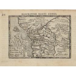
Congi Regni Chriffiani in Africa
Based on the geographical data of Philippo Pigafetta
Date: Amsterdam, c. 1602
Selling price: ????
Please login to see price!
Sold
Hollandiae Antiquorum Catthorum. . .
Prepared by Jacob van Deventer in 1550. It shows Holland in great detail, including small towns, walled cities, rivers and lakes (many of which were reclaimed in the 17th...
Date: Antwerp, 1602
Selling price: ????
Please login to see price!
Sold in 2008
![[Puteoli]](/uploads/cache/26484-250x250.jpg)
[Puteoli]
Rare and early plan of Pozzuoli, in the province of Naples. Its Latin name was Puteoli 'little wells', referring to the many hot springs in the area, most notably Solfata...
Date: Rome, 1586 / 1602
Selling price: ????
Please login to see price!
Sold in 2008
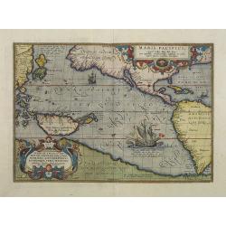
Maris Pacifici.
This was the first printed map to be devoted solely to the Pacific, and the first to name North and South America separately.From the rare Spanish text edition, printed i...
Date: Antwerp, 1602
Selling price: ????
Please login to see price!
Sold in 2009
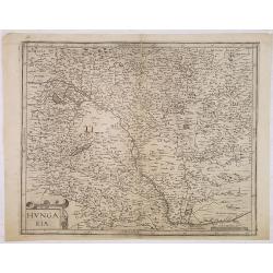
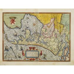
Hungaria.
A scarce map of Hungary by Matteo Florimi (fl.1580-1612) was active in Sienna as a publisher and is perhaps more famous for his town views than his maps. Most of his maps...
Date: Siena, 1602
Selling price: ????
Please login to see price!
Sold in 2012
![Anglia, Regnum si quod aliud in toto Oceano ditissimuin et florentissimum. [imprints] Christophorus Saxton describedat, J.le Clerc ex.](/uploads/cache/28412-250x250.jpg)
Anglia, Regnum si quod aliud in toto Oceano ditissimuin et florentissimum. [imprints] Christophorus Saxton describedat, J.le Clerc ex.
Rare map of England, with elaborate title cartouche, and Royal coat-of-arms A close copy of the Saxton (c.1543-1610) / Ortelius map of 1603, however slightly smaller. Acc...
Date: Paris, 1602
Selling price: ????
Please login to see price!
Sold in 2009
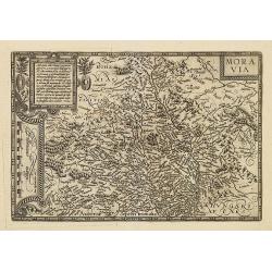
Moravia.
Detailed and uncommon map of Moravia, now the eastern part of the Czech Republic. Including cities of Litta, Boskowitz, Landstein, Austerlitz.
Date: Bussemacher, 1602
Selling price: ????
Please login to see price!
Sold in 2010
Hollandiae Antiquorum Catthorum. . .
Prepared by Jacob van Deventer in 1550. It shows Holland in great detail, including small towns, walled cities, rivers and lakes (many of which were reclaimed in the 17th...
Date: Antwerp, 1602
Selling price: ????
Please login to see price!
Sold in 2016
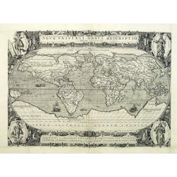
Nova Universi orbis descriptio.
Jodocus Hondius engraved this world map sometime around 1590, and it is only known via this publication by Jean le Clerc in 1602. According to Schilder : Hondius copied ...
Date: Paris, 1590 / 1602
Selling price: ????
Please login to see price!
Sold in 2010
No title: South East Asia.
Very rare map of South East Asia, also including India, China, Japan and the northern tip of Australia , published by Hulsius.The German writer Levinus Hulsius compiled a...
Date: Nuremberg, 1602
Selling price: ????
Please login to see price!
Sold in 2011
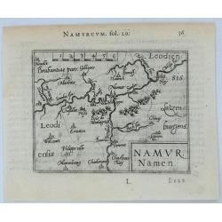
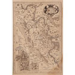
Namur Namen.
A striking, Langenes miniature 1602 copper engraved map of Namur in Belgium. With French text on the verso.BARENT LANGENES (1598-1610) was a publisher in Middelburg about...
Date: Middleburg, 1602
Selling price: ????
Please login to see price!
Sold in 2020
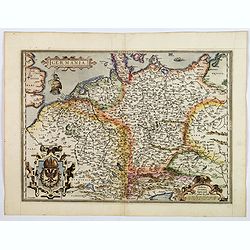
Germania.
A beautiful general map of Germany, including Switzerland, Austria, The Netherlands and Belgium. From a Latin text edition. Based on Christiaan Sgrothen (1520-1608) map o...
Date: Antwerp, ca 1570-1602
Selling price: ????
Please login to see price!
Sold in 2020
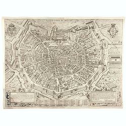
La Gra. Citta di Milano.
Extremely rare city map of Milan. The plan showing the city within the city walls, with the surrounding countryside, title and dedicatory verse set in elaborate strapwork...
Date: Rome, 1602
Selling price: ????
Please login to see price!
Sold in 2025
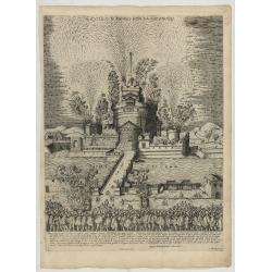
Castello S Angelo Con La Girandola.
A print on the firework display called Girandola at the Castello Sant'Angelo in Rome etched by Brambilla, showing a nocturnal scene, in the background the castle, from th...
Date: Rome, Orlandi, 1602
Selling price: ????
Please login to see price!
Sold in 2025
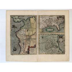
Peruviae Auriferae Regionis Typus. - La Florida - Guastecan.
[3 maps: Florida, Peru and Mexico.] "The Florida map is one of the very few maps printed in the sixteenth century that was based upon original Spanish sources. They ...
Date: Antwerp, 1603
Selling price: ????
Please login to see price!
Sold in 2019
![Tartariae Sive Magni Chami Regni typus. [Alaska and N.America West coast]](/uploads/cache/84445-250x250.jpg)
Tartariae Sive Magni Chami Regni typus. [Alaska and N.America West coast]
Important Map of Asia and North America Included in the World’s First Modern Atlas. It is the earliest obtainable map to name California and is one of the first to incl...
Date: Antwerp, 1603
Selling price: ????
Please login to see price!
Sold in 2021
Maris Pacifici, (quod vulgo Mar del Zur) ...
The first printed map of the Pacific Ocean. Date on the map: 1589, first published 1590. Based on Mercator's world map of 1569. This was the first map to focus on the Pac...
Date: Antwerp, 1589 / 1603
Selling price: ????
Please login to see price!
Sold in 2022
Hollandiae Antiquorum.
A third state of this mile stone map published by Ortelius on the basis of the map drawn by Jacob van Deventer in abt. 1550. Decorated with a large strapwork title cartou...
Date: Antwerp, 1603
Selling price: ????
Please login to see price!
Sold in 2015
Chinae, olim Sinarum Regionis, nova descriptio. Auctore Ludovico Georgio.
The first map of China ever to appear in a Western atlas, west to the top. When this map appeared, it was by far the most accurate one of China.Japan is shown on a curiou...
Date: Antwerp, 1603
Selling price: ????
Please login to see price!
Sold in 2016
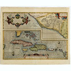
Culiacanae Americae regionis.. / Hispaniolae, Cubae. . .
Two separate virtually identically sized inset maps on one sheet, each with a decorative scroll title cartouche. Culiacanae depicts the coastal and inland western region ...
Date: Antwerp, 1579-1603
Selling price: ????
Please login to see price!
Sold in 2016
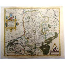
Limburgensis Ducatus Nova Descriptio . .
This hand colored Mercator/Hondius map of the Duchy of Limburg is now of northeastern Belgium and southern Netherlands. Large title cartouche with coat of arms. Latin tex...
Date: Antwerp, 1603
Selling price: ????
Please login to see price!
Sold in 2015
Maris Pacifici, (quod vulgo Mar del Zur) cum regionaribus circumiacentibus, insulisque in eodem passim sparsis, novissima descripto.
This was the first printed map to be devoted solely to the Pacific, and the first to name North and South America separately. It includes most of North and South America,...
Date: Antwerp, 1590-1603
Selling price: ????
Please login to see price!
Sold in 2020
Africae propriae Tabula..
The most beautiful early map of the northern coast of Africa available to the collector. Prepared by Ortelius himself. Ortelius based the map on Gastaldi.
Date: Antwerp, 1603
Selling price: ????
Please login to see price!
Sold in 2018
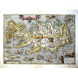
Islandia.
From the Latin text edition of the Theatrum of 1603 (according to van den Broecke only 300 copies printed). The most famous map of Iceland. On the south side a series of ...
Date: Antwerp, 1603
Selling price: ????
Please login to see price!
Sold in 2018
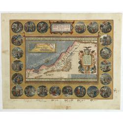
Abrahami Patriarchae Peregrinatio et Vita.
The Holy Land map itself occupies the center and is surrounded by vignettes of the life of the Patriarch Abraham. Extremely decorative map made by Ortelius, based on Ptol...
Date: Antwerp, 1601-1603
Selling price: ????
Please login to see price!
Sold in 2024
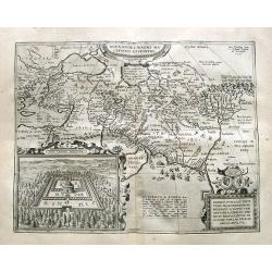
Alexandri Magni Macedonis Expeditio
Detailed map of Alexander the Great's expedition to the Middle East and Persia. The map extends from Greece until east of the Indus river.With a large inset: Iovis Ammoni...
Date: Antwerp, 1603
Selling price: ????
Please login to see price!
Sold in 2019
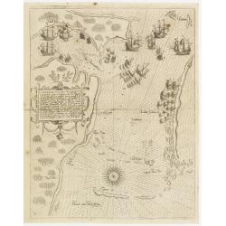
Contrafactur des Scharmutz els der Holander (Singapore)
An especially rare and beautiful map of Strait Singapore, with exquisite calligraphy and superb detail of Dutch and Portuguese ships in Strait Singapore. It shows only th...
Date: Frankfurt 1603
Selling price: ????
Please login to see price!
Sold
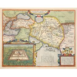
Alexandri Magni Marcedonis Expeditio.
Handsomely engraved map of Alexander the Great's Empire at full flower, with a large inset depicting the Temple of the Oracle of Jupiter Amman, supposedly situated in pre...
Date: Antwerp 1603
Selling price: ????
Please login to see price!
Sold
Peruviae Auriferae.. La Florida.. Guatecan..
Didacus Mendezius' is mentioned on the map as the author of the map, however this person is unknown in cartographical history. Possibly, it derives from Don Diego Hurtado...
Date: Antwerp 1584-1603
Selling price: ????
Please login to see price!
Sold
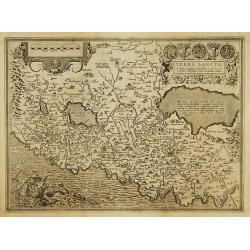
Terra sancta a Petro Laicstain perlustrata?
The Holy Land described by Petrus Laicstain and designed by Christian Schrot. Oriented to the east. Shows the shore line from Birut to Gaza. The shore line is distorted b...
Date: Antwerp 1603
Selling price: ????
Please login to see price!
Sold
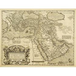
Turcici Imperii Descriptio.
Map of the Middle East, extending from Greece to Arabia and covering the Cradle of Civilisation region. This is a new plate copied from another Ortelius map of 1570 with ...
Date: Antwerp, 1603
Selling price: ????
Please login to see price!
Sold
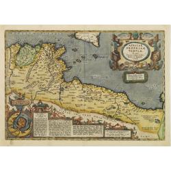
Africae propriae Tabula..
The most beautiful early map of the northern coast of Africa available to the collector. Prepared by Ortelius himself. Ortelius based the map on Gastaldi.
Date: Antwerp 1603
Selling price: ????
Please login to see price!
Sold
Helvetiae descriptio.
A fine map based upon a map by the Swiss cartographer Aegidicus Tschudi of 1538.
Date: Antwerp 1603
Selling price: ????
Please login to see price!
Sold in 2008
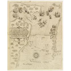
Contrafactur des Scharmutz els der Holander (Singapore)
An especially rare and beautiful map of Strait Singapore, with exquisite calligraphy and superb detail of Dutch and Portuguese ships in Strait Singapore. It shows only th...
Date: Frankfurt, 1603
Selling price: ????
Please login to see price!
Sold