Browse Listings
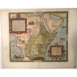
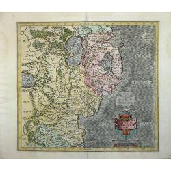
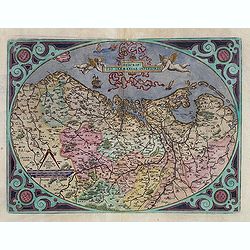
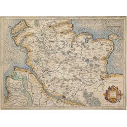
Presbiteri Johannis sive Abissinorum Imperii Descriptio
Very decorative example of Ortelius' famous map of the Kingdom of Prester John, from a Latin edition of Ortelius' Theatrum Orbis Terrarum, the first modern atlas of the w...
Date: Amverpen, 1595
Selling price: ????
Please login to see price!
Sold in 2023
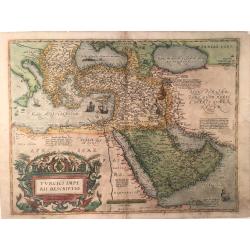
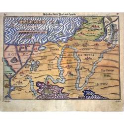
Turcici Imperii Descriptio
This is the second map by Ortelius depicting the Turkish Empire, based on Ortelius' own map of Asia, derived from the work of Giacomo Gastaldi of 1561. It features the Ar...
Date: Antverpen, ca 1595
Selling price: ????
Please login to see price!
Sold in 2023
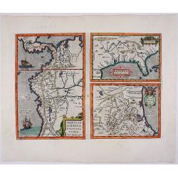
![[Lot of 9 maps/ prints of Egypt ] Aegypti Recentior Descriptio / Carthaginis Celeberrimi Sinus Typus.](/uploads/cache/18309-(8)-250x250.jpg)
[Lot of 9 maps/ prints of Egypt ] Aegypti Recentior Descriptio / Carthaginis Celeberrimi Sinus Typus.
Abraham Ortelius' maps of Egypt and Carthago on one sheet.Abraham Ortelius(1527-98), Dutch cartographer and publisher of the first modern atlas, ' Theatrum Orbis Terrarum...
Date: Antwerp, 1595
Selling price: ????
Please login to see price!
Sold in 2023
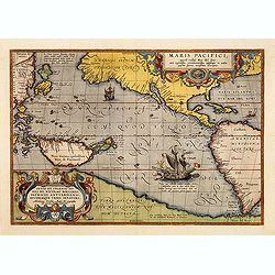
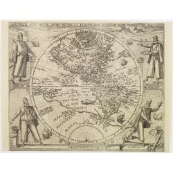
Maris Pacifici.
This was the first printed map to be devoted solely to the Pacific, and the first to name North and South America separately. It includes most of North and South America,...
Date: Antwerp, 1595
Selling price: ????
Please login to see price!
Sold in 2012
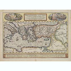
Peregrinationis Divi Pauli Typus...
A splendid map depicting the travels of Paulus. With two fine scenes in top. Showing the countries along the Mediterranean, including Cyprus and Italy. Based on Mercator'...
Date: Antwerp, 1595
Selling price: ????
Please login to see price!
Sold in 2014
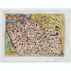
Ultoniae Orientalis Par.
Decorative map of the Ulster Region.From the first edition of Mercator's Atlas, published in 1595. The map features an ornate title cartouche with a scale below. The map...
Date: Duisberg, 1595
Selling price: ????
Please login to see price!
Sold
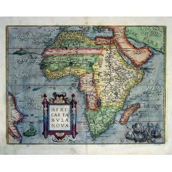
Africae Tabula Nova Edita Antverpiae 1570.
Collectible example of one of the cornerstone maps of Africa. A beautiful map in original color. Ortelius' map was modern in appearance, compared to Munster and o...
Date: Antwerp, (1570) 1595
Selling price: ????
Please login to see price!
Sold
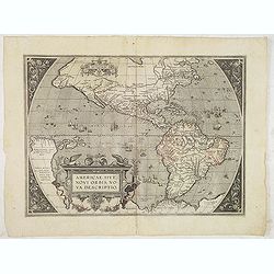
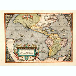
Americae sive novi orbis, nova descriptio.
In 1587, a new plate was engraved which appeared in editions from 1588 onwards. Of the three maps, this one is perhaps the most important. It is the most geographically a...
Date: Antwerp, 1595
Selling price: ????
Please login to see price!
Sold in 2013
Poloniae descriptio.
Early miniature map of Poland from Ortelius' Epitome Theatri Ortelianai. Engraved and published by Philip Galle in Antwerp. Based on Ortelius folio map of Poland. The Epi...
Date: Antwerp, 1577-1595
Selling price: ????
Please login to see price!
Sold in 2014
Descriptio Germaniae Inferioris.
The oval map is surrounded by a strapwork frame and the title, adorned with ribbons, is held aloft by two winged cherubs.According to P. Meurer based on de Jode's 12 shee...
Date: Antwerp, 1595
Selling price: ????
Please login to see price!
Sold in 2015
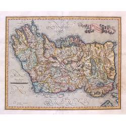
Irlandia Regnum.
Striking map of Ireland, with north oriented to the right and featuring a splendid ribbon style title banner cartouche. Fully engraved with topographical features and a s...
Date: Amsterdam, 1595
Selling price: ????
Please login to see price!
Sold in 2017
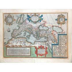
ROMANI IMPERII IMAGO.
Very decorative map of the ancient Roman empire. The medallion portraits Romulus and Remus.This map belongs to a series of historical maps known as the "Parergon The...
Date: Antwerp 1595
Selling price: ????
Please login to see price!
Sold in 2013
Americae sive novi orbis, nova descriptio.
In 1587, a new plate was engraved which appeared in editions from 1588 onwards. Of the three maps, this one is perhaps the most important. It is the most geographically a...
Date: Antwerp, 1595
Selling price: ????
Please login to see price!
Sold in 2014
Holsatia Ducatus.
A detailed map of the Schleswig-Holstein area of Germany extending south to include Hamburg and Lubeck. From the first edition of Mercator's Atlas. Latin text verso
Date: Duisberg, 1595
Selling price: ????
Please login to see price!
Sold in 2014
Reisen der Kinder Israel aus Egypten.
A woodblock map which illustrates the route followed by the Israelites in the Exodus from Egypt to the Promised Land. The map is very decorative and shows the Pharaoh dro...
Date: Magdeburg, 1595
Selling price: ????
Please login to see price!
Sold in 2014
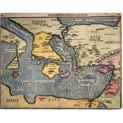
Tafel der Lender / darin der Apostel Paulus geprediget hat.
Woodcut showing the Eastern Mediterranean from the "Itinerarium Sacrae Scripturae", showing Italy, Sicily, Greece, Cyprus, Asia Minor, the Holy Land and North A...
Date: Magdeburg, 1595
Selling price: ????
Please login to see price!
Sold in 2017
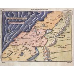
Beschreibung des Heiligen Landes.
Heinrich Bünting map of the Holy Land from the Itinerarum Saccrae Scripturae, which was first published in 1581. It shows Palestineon both sides of the Jordan and the tw...
Date: Magdeburg, 1595
Selling price: ????
Please login to see price!
Sold in 2014
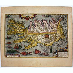
Islandia.
Perhaps the most famous map of Iceland. On the south side of the island a collection of all possible sea monsters is depicted. Polar bears on ice flows and volcanoes in t...
Date: Antwerp, 1595
Selling price: ????
Please login to see price!
Sold in 2014
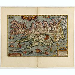
Islandia.
Perhaps the most famous map of Iceland. On the south side of the island a collection of all possible sea monsters is depicted. Polar bears on ice flows and volcanoes in t...
Date: Antwerp, 1595
Selling price: ????
Please login to see price!
Sold in 2015
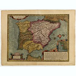
Hispaniae Veteris descriptio.
Made on the basis of modern information from Clusius' six-sheet map of Spain which appeared in 1571 and ancient knowledge from Strabo, Appianus, Bongarius, Livius, Valeri...
Date: Antwerp, 1595
Selling price: ????
Please login to see price!
Sold in 2015
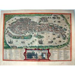
Venetia.
Superb bird's-eye view of Venice, which precisely illustrates most of the architectural features of the city. The lagoon is also depicted, animated with many vessels. The...
Date: Cologne, circa 1595
Selling price: ????
Please login to see price!
Sold in 2015
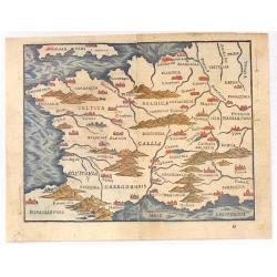
Gallia.
Rather crude but quite charming little woodcut map of Gallia with Celtica, Aquitania, Angliar Pars, Narbonensis, Hispaniae Pars etc., based on Ortelius. Published in 1595...
Date: Venice, 1595
Selling price: ????
Please login to see price!
Sold in 2016
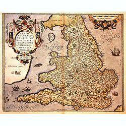
Angliae Regni flo: rentissimi nova descriptio, auctore Humfredo Lhuyd Cum Privilego.
Map by Humphrey Lloyd, Denbigh with coast shaded sea borders, rivers, hillocks, forests and towns. Published by Abraham Ortelius. The map presents an interesting picture ...
Date: Antwerp, 1595
Selling price: ????
Please login to see price!
Sold in 2016
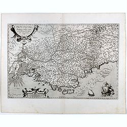
Provinciae, Regionis Galliae, vera exactissimaq. Descriptio..
Early imprint of this decorative map of the Province prepared by Pierre-Jean de Bompar who published a single sheet map of the Province in 1591.Title cartouche on the upp...
Date: Antwerp, 1595
Selling price: ????
Please login to see price!
Sold in 2016
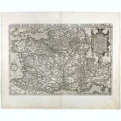
Galliae Regni Potentiss: Nova Descriptio Ioanne Ioliveto Auctore.
A decorative view of 16th Century France that is derived from Jean Jolivet's woodcut map of 1560. Decorated with one large cartouche and one smaller royal crest. The map ...
Date: Antwerp, 1595
Selling price: ????
Please login to see price!
Sold in 2016
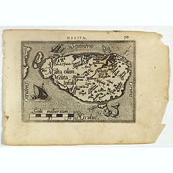
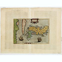
Malta olim Melita Insula.
Miniature map of Malta. From the second series of miniature atlas of Ortelius' Epitome. A new series of pocket-size atlases was begun by Philip Galle in 1588. It seems th...
Date: Antwerp, 1595
Selling price: ????
Please login to see price!
Sold in 2017
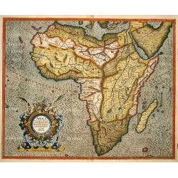
Africa ex magna orbis terre descriptione Gerardi Mercatories desumpta studio & industria G.M. Juniorius
A classic and important map of Africa, especially as it is directly based on Gerard Mercator’s rare wall map of the world of 1569. The map first appeared in Gerard Merc...
Date: Duisburg and then Amsterdam, 1595
Selling price: ????
Please login to see price!
Sold in 2017
La Florida_Guastecan_Peruviae Avriferae Regionis Typus.
The most important map (La Florida) is the first printed map of the southeastern region of the United States. This influential map provided the foundation cartography for...
Date: 1595
Selling price: ????
Please login to see price!
Sold in 2017
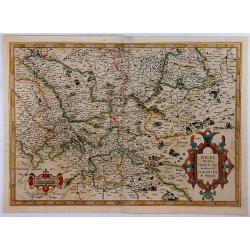
Berghe Ducatus Marck comitatus et Coloniensis Dioecisis.
A rare first edition of Mercator's detailed map of Germany, from the first addition (1595) of Mercator's atla, “Atlas Sive Cosmographia”. The map covers a large secti...
Date: Amsterdam, 1595
Selling price: ????
Please login to see price!
Sold in 2018
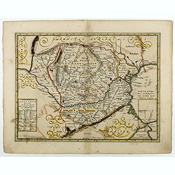
Vetus Descriptio Daciarum Nec non Moesiarum.
Decorative map of Romania, Signed lower part : Petrus Kaerius Caelavit. No text on verso. Extremely rare early or proof state of Jan Jansson's map of Romania, pre-dating ...
Date: Antwerp, 1595
Selling price: ????
Please login to see price!
Sold in 2018
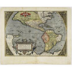
Americae Sive Novi Orbis Nova Descriptio.
A beautiful colored map of the American continent which comes from the Latin edition of Theatrum Orbis Terrarum by Abraham Ortelius. This is the third plate that Ortelius...
Date: Antwerp, 1595
Selling price: ????
Please login to see price!
Sold in 2020
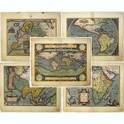
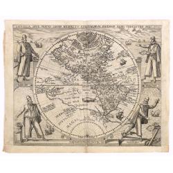
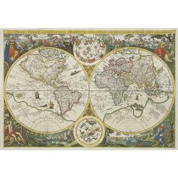
Set of world & four continents in stunning original colors.
An attractive set of these decorative and important maps published at Antwerp in Ortelius' Theatrum. The Theatrum was the first large modern atlas and was extremely influ...
Date: Antwerp, 1595
Selling price: ????
Please login to see price!
Sold in 2023
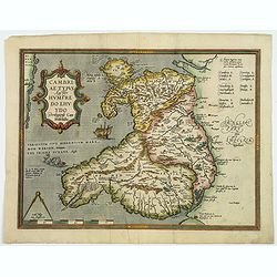
Cambriae Typus Auctore Humfredo Lhuydo Denbigiense Cambrobritano.
A beautiful hand colored copper-engraved map of Wales. It is the first separately printed map of Wales, by Humphrey Lhuyd. This is the second variant of the Ortelius publ...
Date: Antwerp, ca 1595
Selling price: ????
Please login to see price!
Sold in 2019
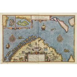
Insulae et arcis MOCAMBIQUE descriptio...Beschrijuinge des..
This is a finely executed copperplate engraved map of Mozambique Island, a strategically important re-supply point for the Portuguese empire in Asia during the 16th centu...
Date: Amsterdam, 1596
Selling price: ????
Please login to see price!
Sold in 2013
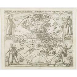
America sive novus orbis respectu Europaeorum inferior globi terrestris pars 1596.
An especially rare and beautiful hemisphere map of the Americas, with exquisite calligraphy and superb portraits of Columbus, Magellan, Vespucci and Pizarro adorning the ...
Date: Frankfurt, 1596
Selling price: ????
Please login to see price!
Sold in 2018
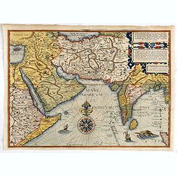
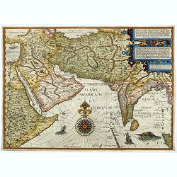
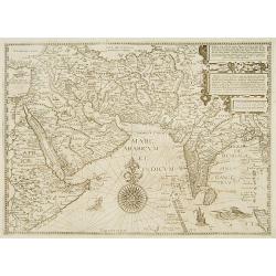
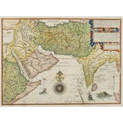
Afbeeldinge der custen van Abex, der engte van Mecha..
A highly decorative and distinctive map showing eastern Africa, Arabia, Persia and India, with rhumb lines and decorative compass roses in sea areas. A lion, elephant and...
Date: Amsterdam, after 1596
Selling price: ????
Please login to see price!
Sold in 2014
Japonia Regnum.
Very rare map and one of the earliest views of Japan and Korea and was published in a German edition of Botero's "Theatrum Principum Orbis Universi."This is a v...
Date: Cologne, Lambert Andreas, 1596
Selling price: ????
Please login to see price!
Sold in 2015
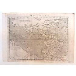
America.
Copper engraved map; overall size 14 x 20 cm by Giovanni Antonio Magini, from the: 'Geographiae Universae'. According to Burden, this is a reduced version of a map by d...
Date: Venice, 1596
Selling price: ????
Please login to see price!
Sold in 2015
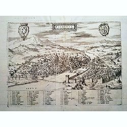
FLORENZA (Florence)
Rare Lafreri School town-plan of Florence, engraved by Paolo Forlani, of the Lafreri school of mapmakers, first published in "Il Primo Libro Delle Citta, Et Fortezze...
Date: Venice, 1596
Selling price: ????
Please login to see price!
Sold in 2016
WITTENBERG.
Rare Lafreri School town-plan of Wittenberg, and church marked by Luther, engraved by Paolo Forlani, of the Lafreri school of mapmakers, first published in "Il Primo...
Date: Venice, 1596
Selling price: ????
Please login to see price!
Sold in 2019
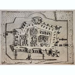
METZ.
Rare Lafreri School of the siege of Metz by imperial troops of Charles V in 1552-1553, engraved by Paolo Forlani, of the Lafreri school of mapmakers, first published in &...
Date: Venice, 1596
Selling price: ????
Please login to see price!
Sold in 2018
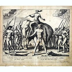
Cochini Rex elephante vectus, cum procerum comitatu, quos Nairos...
In this elegant copperplate engraving you see the King of Cochin, astride an Elephant leading his army, gathered below him. Linschoten was a Dutch Merchant, Trader and Hi...
Date: Amsterdam, after 1596
Selling price: ????
Please login to see price!
Sold in 2016
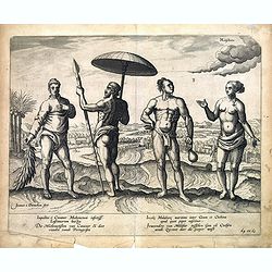
Inquilini e Cananor Mahometani infectiss Lusitanorum hostes...
In this attractive copperplate engraving you see a Moslem from Cananor in Kerala, India, and the inhabitants of the Malabar coast between Goa and Cochin, with a rural sce...
Date: Amsterdam, after 1596
Selling price: ????
Please login to see price!
Sold in 2016

Virginis Lusitane in India gestus et amictus...Der Portugeesen gehoude Vrouwen habyt en cyraet...
In this detailed copperplate engraving you seethe various costume and dress of Portuguese ladies and rank. Linschoten was a Dutch Merchant, Trader and Historian, who trav...
Date: Amsterdam, after 1596
Selling price: ????
Please login to see price!
Sold in 2016
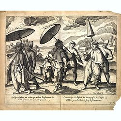
Gestus et habitus tam civium que militum Lusitanorum in oriente agentium...
In this charming copperplate engraving you see wealthy Portuguese citizens and soldiers of the East Indies, in all their finery, walking under umbrellas. Linschoten was a...
Date: Amsterdam, after 1596
Selling price: ????
Please login to see price!
Sold in 2016

Malache incole sermone et moribus quam reliqui Indi...Insulanus e Java gens dure cervicis.
In this well engraved copperplate engraving you see men and women of Malacca and Java, standing on a clifftop, with their city sprawled beneath them. Linschoten was a Dut...
Date: Amsterdam, after 1596
Selling price: ????
Please login to see price!
Sold in 2016
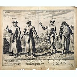
Mercador / Baniane / Bramene.
In this attractive copperplate engraving you see various peoples of the Indies, including a merchant and a Brahmin priest. In the background people pray before an idol se...
Date: Amsterdam , after 1596
Selling price: ????
Please login to see price!
Sold in 2016
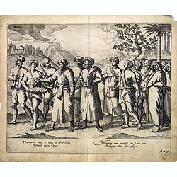
Nuptiarum ritus, et epule in Provincia Ballagate supra Goam.
In this charming copperplate engraving you see a Wedding ceremony in Goa, bride and groom, family and friends and musicians.Linschoten was a Dutch Merchant, Trader and Hi...
Date: Amsterdam, after 1596
Selling price: ????
Please login to see price!
Sold in 2016
Als Konig Heinrich Von Naverr . . .
Early print showing Henry of Navarra (1553–1610) baptized in Rome on 23 September 1595.Plate from the series about the "Eighty Years' War" or the Independence...
Date: Cologne, ca. 1596
Selling price: ????
Please login to see price!
Sold in 2019
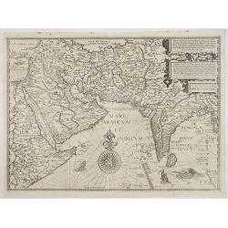
Afbeeldinge der custen van Abex, der engte van Mecha..
A highly decorative and distinctive map showing eastern Africa, Arabia, Persia and India. Around India several manuscript annotations in brown ink. With rhumb lines and d...
Date: Amsterdam, 1596
Selling price: ????
Please login to see price!
Sold in 2017
Antique map of the Americas / America.
An Girolano Porro elegantly engraved map of the Americas, from Giovanni Antonio Magini's edition of Ptolemy's 'Geography', titled 'Geographia Universae'.
Date: Venice, 1596
Selling price: ????
Please login to see price!
Sold in 2017
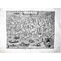
Islandia.
A fine, strong impression example of the famous Quad's map of Iceland. It can be considered a reduced version of Ortelius' "Islandia", the first realistic map o...
Date: Cologne, 1596
Selling price: ????
Please login to see price!
Sold in 2019
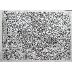
Artesia cuius incolae Atrebates. . .
A scarce copper engraved map of the Arras region of France by Matthias Quad, a German cartographer based in Cologne. Engraved by Johannes Bussemacher. The map shows the a...
Date: Cologne, ca 1596
Selling price: ????
Please login to see price!
Sold in 2018
Americvs Vespvccivs Florentinvs..
From a series composed in 1592, to celebrate the centenary of the discovery of the New World by Columbus, and the following explorations by Vespucci and Magellan. The eng...
Date: Antwerp, 1596
Selling price: ????
Please login to see price!
Sold in 2018
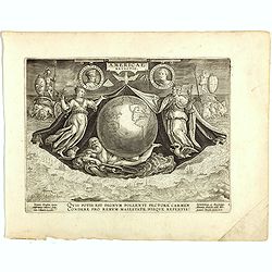
America Retectio.
The print shows an allegory of Neptune supporting the globe, which is flanked by Flora, representing Florence, and Janus, representing Genoa (birthplaces of Vespucci and ...
Date: Antwerp, 1596
Selling price: ????
Please login to see price!
Sold in 2018
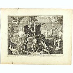
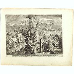
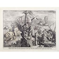
Ferdinandes Magellanes Lusitanus. . .
Showing Magellan involved in navigational pursuits, although he suffers from a broken mast, the fires of Tierra de Fuego burn on the coast to the left, in all three plate...
Date: Antwerp, 1596
Selling price: ????
Please login to see price!
Sold in 2018
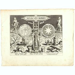
Nova Reperta.
Title-page from a series of twenty prints illustrating new inventions and discoveries (Nova Reperta) after Jan van der Straet. Lettered on image: 'NOVA REPERTA,' on left ...
Date: Antwerp, 1596
Selling price: ????
Please login to see price!
Sold in 2018
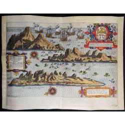
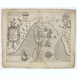
Vera effigies et delineatio Insulae, Ascencio nuncupatae (...) Waerachtighe affbeeldinghe en verthooninghe vant Eylant Asçençion (...)
A rare copper engraved bird's eye view by B. VAN DOETECUM of the island of Ascension in the South Atlantic Ocean. Panorama showing the island in three profile views, engr...
Date: Amsterdam, 1596
Selling price: ????
Please login to see price!
Sold in 2019
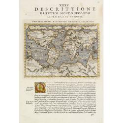
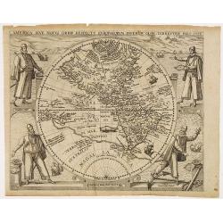
Universi Orbis Descriptio ad usum navigantium.
Magini's mariner's map follows Gerard Mercator's large world map of 1569 on a much reduced scale and with the fanciful addition of chains of mountains across the southern...
Date: Venise, 1596
Selling price: ????
Please login to see price!
Sold in 2008
Afbeeldinge der custen van Abex, der engte van Mecha..
A highly decorative and distinctive map showing eastern Africa, Arabia, Persia and India. Around India several manuscript annotations in brown ink. With rhumb lines and d...
Date: Amsterdam 1596
Selling price: ????
Please login to see price!
Sold
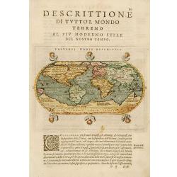
Universi Orbis Descriptio.
Modern world map from Magini's atlas following the oval projection popularized by Ortelius. Porro has astutely reduced Ortelius' much larger map to octavo page size with ...
Date: Venise 1596
Selling price: ????
Please login to see price!
Sold
Afbeeldinge der custen van Abex, der engte van Mecha..
A highly decorative and distinctive map showing eastern Africa, Arabia, Persia and India, with rhumb lines and decorative compass roses in sea areas. A lion, elephant and...
Date: Amsterdam 1596
Selling price: ????
Please login to see price!
Sold
Universi Orbis Descriptio ad usum navigantium.
Magini's mariner's map follows Gerard Mercator's large world map of 1569 on a much reduced scale and with the fanciful addition of chains of mountains across the southern...
Date: Venise 1596
Selling price: ????
Please login to see price!
Sold
America sive novus orbis respectu Europaeorum inferior globi terrestris pars 1596.
An especially rare and beautiful hemisphere map of the Americas, with exquisite calligraphy and superb portraits of Columbus, Magellan, Vespucci and Pizarro adorning the ...
Date: Frankfurt 1596
Selling price: ????
Please login to see price!
Sold
Germania.
Giovanni Antonio Magini (1555-1617), Italian mathematician and cartographer. Edited edition of Ptolemy's ' Geographia', 1596.The 'modern' map of Germany. An elegantly eng...
Date: Venice, 1596
Selling price: ????
Please login to see price!
Sold in 2018
Americvs Vespvccivs Florentinvs..
A very good impression, printed with tone and displaying very good contrasts and clarity of details. From a series composed in 1592, to celebrate the centenary of the dis...
Date: Antwerp 1596
Selling price: ????
Please login to see price!
Sold
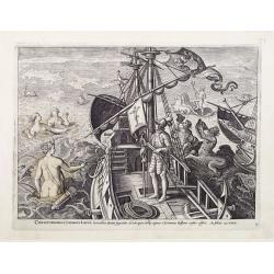
Christophorvs Colvmbvs Ligvr..
A very good impression, printed with tone and displaying very good contrasts and clarity of details. From a series composed in 1592, to celebrate the centenary of the dis...
Date: Antwerp 1596
Selling price: ????
Please login to see price!
Sold
Orbis terrae compendiosa descriptio..
Very rare large double hemisphere world map, with the address of Joan Baptistum Vrients. A close copy of Plancius' 1594 world map. The map is engraved by Arnoldus and Hen...
Date: Antwerp 1596
Selling price: ????
Please login to see price!
Sold
America sive novus orbis respectu Europaeorum inferior globi terrestris pars 1596.
An especially rare and beautiful hemisphere map of the Americas, with exquisite calligraphy and superb portraits of Columbus, Magellan, Vespucci and Pizarro adorning the ...
Date: Frankfurt, 1596
Selling price: ????
Please login to see price!
Sold
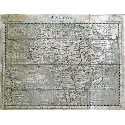
AFRICA.
This is Giovanni Magini's modern map of Africa from his edition of Claudius Ptolemy's Geographia. It is basically a slightly-reduced version of the D'Anania 1582 map of...
Date: Venice, 1596
Selling price: ????
Please login to see price!
Sold in 2013
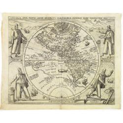
America sive novus orbis respectu Europaeorum inferior globi terrestris pars 1596.
An especially rare and beautiful hemisphere map of the Americas, with exquisite calligraphy and superb portraits of Columbus, Magellan, Vespucci and Pizarro adorning the ...
Date: Frankfurt, 1596
Selling price: ????
Please login to see price!
Sold in 2013
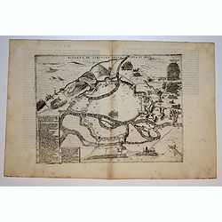
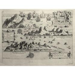
Hydrographica Septentrionalis Norvegiae partis descriptio. . . / Beschrijvinghe der Zeecusten vant Nordelicxste deel van Norweghen. . .
A detailed chart of the coast of Norway and Lapland. Decorated by a colorful title cartouche and scale cartouche, two compass roses, several vessels and sea monsters, and...
Date: Amsterdam, C.Claesz, 1596
Selling price: ????
Please login to see price!
Sold in 2008
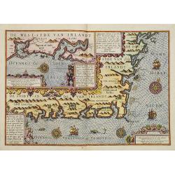
Beschrivinge der zeecusten van de Züijtsijde ende de Oos t-sijde van Irlandt. . . .
A detailed chart of the coast of the western side of Ireland. Decorated by a title cartouche and scale cartouche, four compass roses, several vessels and sea monsters, an...
Date: Amsterdam, C.Claes, 1596
Selling price: ????
Please login to see price!
Sold in 2008
Afbeeldinge der custen van Abex, der engte van Mecha..
A highly decorative and distinctive chart showing eastern Africa, Arabia, Persia and India, with rhumb lines and decorative compass roses in sea areas. A lion, elephant a...
Date: Amsterdam, 1596
Selling price: ????
Please login to see price!
Sold in 2008
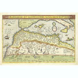
Barbariae et Biledulgerid, nova descriptio.
North-West Africa. Koeman speculated: In view of the important trading relationship between Antwerp and Africa, it is not impossible that the original was a manuscript ma...
Date: Amsterdam, 1596
Selling price: ????
Please login to see price!
Sold

Orbis terrae compendiosa descriptio. . .
Very rare large double hemisphere world map, with the address of Joan Baptistum Vrients, made for the first edition of Linschoten's "Itinerario" (1596) publishe...
Date: Antwerp, 1596
Selling price: ????
Please login to see price!
Sold
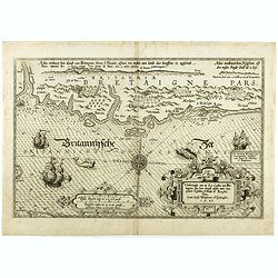
Verthoninghe van de Zee Custen van Bretaignen.
A very decorative chart covering the coast along the coast of Britany. South to the top. A first edition, without the privilege. Engraved by the master engraver, Johannes...
Date: Amsterdam, 1596
Selling price: ????
Please login to see price!
Sold in 2018
America sive novus orbis respectu Europaeorum inferior globi terrestris pars 1596.
An especially rare and beautiful hemisphere map of the Americas, with exquisite calligraphy and superb portraits of Columbus, Magellan, Vespucci and Pizarro adorning the ...
Date: Frankfurt, 1596
Selling price: ????
Please login to see price!
Sold in 2010
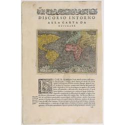
Discorso intorno alla carta da navigare.
An early edition of Porcacchi's mariner's map follows Gerard Mercator's large world map of 1569 on a much reduced scale. From "L'Isole piu Famose del Mondo" (Th...
Date: Venise, 1596
Selling price: ????
Please login to see price!
Sold in 2016
Vera effigies et delineatio Insulae Ascenscio nuncupatae sitae in altitudine 8 graduum ad austrum lineae aequinoctialis.
This is Linschoten's map of Ascension Island in the south Atlantic, beautifully engraved by Baptista a Doetechum.Decorative print showing three coastal views of Ascension...
Date: Amsterdam, c.1596
Selling price: ????
Please login to see price!
Sold in 2012