Browse Listings
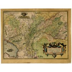
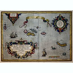
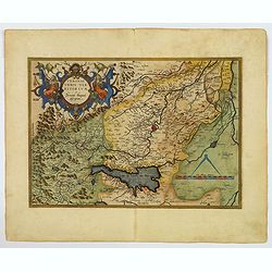
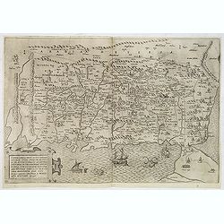
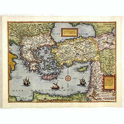
Gelria, Cliviae, Fini Timorumque Locorum Verissima Descriptio ...
Very decorative map of Gelderland and a part of Cleves in Germany. Shows two ships and a decorative cartouche with birds. Based on a manuscript map by Christiaan Sgrothen...
Date: Antwerp, 1592
Selling price: ????
Please login to see price!
Sold in 2021
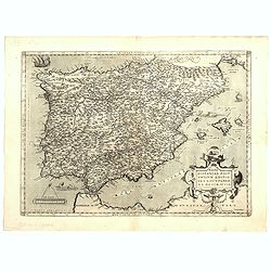
Regni Hispaniae Post Omnium Editio..
Very decorative map of Spain and Portugal, including Majorca and Minorca. According to Marcel van den Broecke: Estimated number of copies printed: 8175 Estimated nu...
Date: Antwerp, 1592
Selling price: ????
Please login to see price!
Sold in 2023
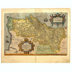
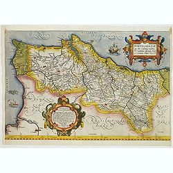
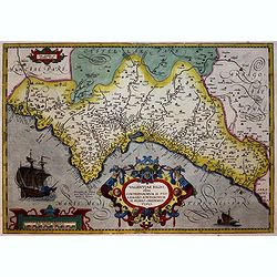
Portugalliae que olim Lusitania.
The best-known map of Portugal, after Alvares Secco (1560), map is orientated west to the top of the sheet, seen here in a fine, early impression in good color. Fernando ...
Date: Antwerp, 1592
Selling price: ????
Please login to see price!
Sold in 2023
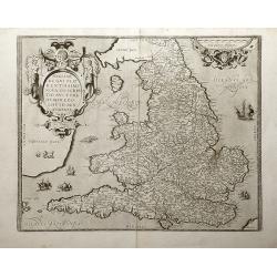
Angliae Regni Florentissimi Nova Descriptio, Auctore Humfredo Lhuyd Denbygiense. 1573.
Attractive map of England and Wales compiled from Mercator's 1564 wall map of the British Isles and Lhuyd's manuscript map of 1568. The countryside is fully engraved with...
Date: Antwerp, 1592
Selling price: ????
Please login to see price!
Sold in 2012
Portugalliae que olim Lusitania.
The best-known map of Portugal, after Alvares Secco (1560), orientated west to the top of the sheet, seen here in a fine, early impression in bright contemporary color. S...
Date: Antwerp, ca.1592
Selling price: ????
Please login to see price!
Sold
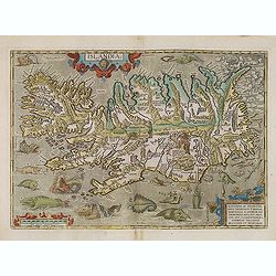
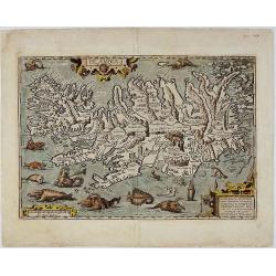
Islandia.
Perhaps the most famous map of Iceland. On the south side of the island a collection of all possible sea monsters is depicted. Polar bears on ice flows and volcanoes in t...
Date: Antwerp, 1592
Selling price: ????
Please login to see price!
Sold in 2013
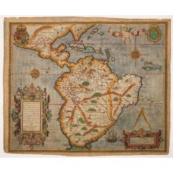
Americae Pars Magis Cognita. Chorographia nobilis & opulentae Peruanae Provinciae, atque Brasiliae, . . . MDXCII
Although a map of South America it does include much of what is now the southern United States. There are two elaborate, strap-work cartouches with the one at lower right...
Date: Frankfurt, 1592
Selling price: ????
Please login to see price!
Sold in 2014
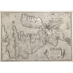
ANGLIAE, SCOTIAE ET HIBERNIAE, SIVE BRITANNICAR: INSVLARVM DESCRIPTIO.
A beautiful map of the British Isles, north to the right. The map is based on Mercator's earlier map of the British Isles of 1564. Title in strapwork cartouche at top rig...
Date: Antwerp 1592
Selling price: ????
Please login to see price!
Sold in 2016
Universe Europae Maritime Eiusque Navigationis Descriptio. Generale Pascaerte van Europa . . .
This general chart of western Europe and the surrounding coastal waters is from the rare pilot-guide Spieghel der Zeevaerdt ,first printed by Christopher Plantin in Leyde...
Date: Amsterdam, 1592
Selling price: ????
Please login to see price!
Sold in 2015
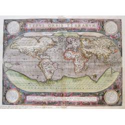
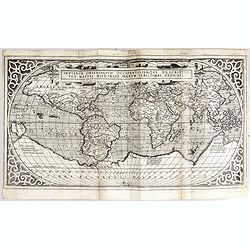
Typus Orbis Terrarum
Ortelius' third world map, here an early latin edition from 1592 (1592L1 (525 copies printed) 3rd textline from the top ends: Africam; last line, in two columns: ANTONIVS...
Date: Antwerp, 1592
Selling price: ????
Please login to see price!
Sold in 2015
La Florida/ Peruviae Auriferae regionis Typus/ Guastecan.
The Chaves map of Florida is a prime example of an explorer's map since it records the recent discoveries of Cabeza de Vaca, De Soto, and Moscoso. The map revealed little...
Date: Antwerp, 1592
Selling price: ????
Please login to see price!
Sold in 2016
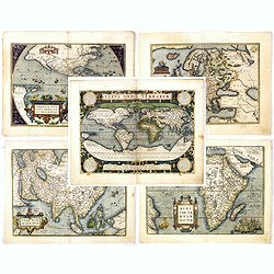
Set of world & four continents.
An attractive set of these decorative and important maps published at Antwerp in Ortelius' Theatrum. The Theatrum was the first large modern atlas and was extremely influ...
Date: Antwerp, 1592
Selling price: ????
Please login to see price!
Sold in 2016
Acores Insulae.
Important map of Ortelius of the strategic islands of the Azores, in the 16th century an important hub from the Spanish Americas and the Silver fleet. The observation of ...
Date: Antwerp, 1592
Selling price: ????
Please login to see price!
Sold in 2018
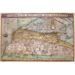
Barbariae Et Biledvlgerid...
Remarkable map of Northern Africa in an early shape. Extends from Morocco and the Sahara to Libya and large parts of the Mediterranean, including the Balearic Islands, Si...
Date: Antwerp, 1592
Selling price: ????
Please login to see price!
Sold in 2016
Valentiae Regni.
Early map of Valencia. The second plate, which is very similar to the first, but which has cursive rather than straight capitals for MARIS MEDITERRANEI PARS at the bottom...
Date: Antwerp, 1592
Selling price: ????
Please login to see price!
Sold in 2017
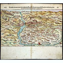
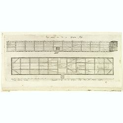
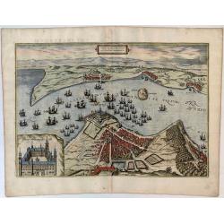
Warhaffte abcontrafactur der namhafften Statt St. Quintin sampt aller Laegerstatt und umbligenden Ort wie sie von Konigs Philippi Heer im jar 1557 belagert worden.
On recto a wood block printed view of the town of St. Quintin besieged by the army of Spanish King Philip II in 1557. From a German text edition of his Geographia , that ...
Date: Basle, 1592
Selling price: ????
Please login to see price!
Sold in 2018
Islandia.
One of the most decorative atlas maps of all time published by Abraham Ortelius in his atlas “Theatrum Orbis Terrarum”. The map depicts Iceland in truly remarkable de...
Date: Antwerp, 1592
Selling price: ????
Please login to see price!
Sold in 2018
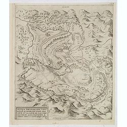
Veronae Urbis Territorium.
A very fine map of part of Italy, centered on Verona, Vizenza and Lake Garda. Prepared by Bernardino Brugnoli, which was first published in 1574 by Forlani. This Ortelius...
Date: Antwerp, 1592
Selling price: ????
Please login to see price!
Sold in 2019
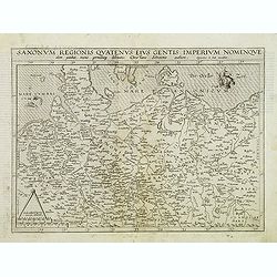
Saxonum regionis quatenus eius gentis imperium nomenquqe olim patebat, recens germanaque delineatio. . .
Map of north east Germany with part of Poland. Like all de Jode maps: scarce and much sought after.
Date: Antwerp, 1593
Selling price: ????
Please login to see price!
Sold in 2012
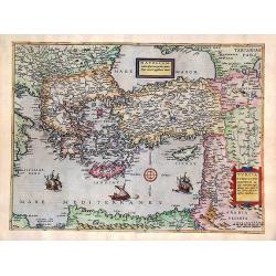
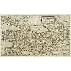
Natoliam Moderni dicunt tam partem quam Asiam minrem appelauere veteres (with Cyprus)
Engraved by Van Deutecum, this is a spectacular example of the 1593 edition of the very rare De Jode's map of the Eastern Mediterranean and Asia Minor. It has two title c...
Date: Antwerp, 1593
Selling price: ????
Please login to see price!
Sold in 2014
Terrae Israel omnis ante Canaan dictae in tribus undecim ... A. Bened. Aria Montano descripta.
Land of Israel, previously called Canaan, divided into 11 Tribes, showing also the neighboring regions and the 43 stations of the Israelites in the desert.The shore line ...
Date: Antwerp, 1572 / Leiden, 1593
Selling price: ????
Please login to see price!
Sold in 2020
Antiquae Ierusalem vera icnographia ad Sacræ Lectionis Præ-cipue et Aliarum de Ila Urbe Historiar. Explicationem Ex collatione auctoru tu ruinaru uestigiis ac situ ipso.
An "imaginary typographic plan" of ancient Jerusalem. Delano-Smith & Ingram describe it as "east oriented with mountains ringing the city and closing t...
Date: Antwerp, 1572 / Leiden, 1593
Selling price: ????
Please login to see price!
Sold in 2013
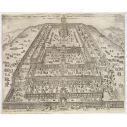
Montis Domini totiusque Sacri Templi exemplum ex antiquis descriptionibus a Bened Aria Montano observatis ad Apparatus Sacri. . .
Striking view of the Temple, filled with worshippers, merchants, soothsayers, cattle, sheep, poultry, etc.From Benedictus Arias Montanus' Antiquitatum Iudicarum Libri IX....
Date: Antwerp, 1572 / Leiden, 1593
Selling price: ????
Please login to see price!
Sold in 2013
![Sacerdotis antiqui sanctis vestibus et ornamentis instructi exemplum / ex descriptione Mosis. . . [Hebrew priest]](/uploads/cache/33274-250x250.jpg)
Sacerdotis antiqui sanctis vestibus et ornamentis instructi exemplum / ex descriptione Mosis. . . [Hebrew priest]
Fine engraving of a Hebrew priest. From Benedictus Arias Montanus' Antiquitatum Iudicarum Libri IX. In quis, praeter Iudaeae, also in Liber Chanaan, and his rare Biblia P...
Date: Antwerp, 1572 / Leiden, 1593
Selling price: ????
Please login to see price!
Sold
![[ The Israelites in their camp ]](/uploads/cache/33275-250x250.jpg)
[ The Israelites in their camp ]
Fine engraving of The Israelites in their camp. This plate was the frontispiece of Vol. VIII of the Polyglot Bible. From Benedictus Arias Montanus' Antiquitatum Iudicarum...
Date: Antwerp, 1572 / Leiden, 1593
Selling price: ????
Please login to see price!
Sold in 2013
![[Schematic of the Temple in Jerusalem. ]](/uploads/cache/33278-250x250.jpg)
[Schematic of the Temple in Jerusalem. ]
Schematic of the Temple in Jerusalem.From Benedictus Arias Montanus' Antiquitatum Iudicarum Libri IX. In quis, praeter Iudaeae, also in Liber Chanaan, and his rare Biblia...
Date: Antwerp, 1572 / Leiden, 1593
Selling price: ????
Please login to see price!
Sold in 2013
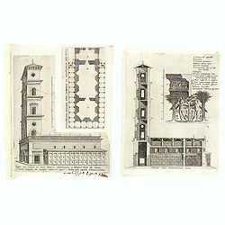
(2 prints) Sacrae aedis sciographiae pars. / Templi cum porticu et cellis absoluta orthographia ...
Two engraving from Arias Montanus, Benito "Antiquitatum Iudicarum Libri IX. In quis, praeter Iudaeae, Hierosolymorum, & Templi Salomonis accuratam delineationem,...
Date: Antwerp, 1572 / Leiden, 1593
Selling price: ????
Please login to see price!
Sold in 2015
(The Ark.)
Engraving of The Ark of Moses from Arias Montanus, Benito "Antiquitatum Iudicarum Libri IX. In quis, praeter Iudaeae, Hierosolymorum, & Templi Salomonis accurata...
Date: Antwerp, 1572 / Leiden, 1593
Selling price: ????
Please login to see price!
Sold in 2015
Sacri tabernaculi. . . (Four engravings of the Holy Tabernacle.)
Four engraving of the Holy Tabernacle from Arias Montanus, Benito "Antiquitatum Iudicarum Libri IX. In quis, praeter Iudaeae, Hierosolymorum, & Templi Salomonis ...
Date: Antwerp, 1572 / Leiden, 1593
Selling price: ????
Please login to see price!
Sold in 2015
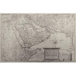
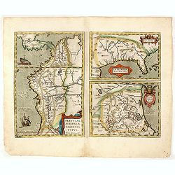
Secundae partis Asiae, typus.
Excessively rare map of the Arabian Peninsula. Map 9 from: "Speculum orbis terrarum" by Gerard and Cornelis de Jode. Latin text verso: Asiae secunda pars sive A...
Date: Antwerp, 1593
Selling price: ????
Please login to see price!
Sold in 2016
![[South America] Delineatio omnium orarum totius Australis partis Americae. . .](/uploads/cache/34876-250x250.jpg)
[South America] Delineatio omnium orarum totius Australis partis Americae. . .
A particularly decorative example of Dutch cartography boasting two intricate strapwork cartouches. Exotic animals and bellicose Indians populate the continent, while in ...
Date: Amsterdam, 1593
Selling price: ????
Please login to see price!
Sold in 2014
![[South America] Delineatio omnium orarum totius Australis partis Americae. . .](/uploads/cache/35162-250x250.jpg)
[South America] Delineatio omnium orarum totius Australis partis Americae. . .
A particularly decorative example of Dutch cartography boasting two intricate strapwork cartouches. Exotic animals and bellicose Indians populate the continent, while in ...
Date: Amsterdam, after 1593
Selling price: ????
Please login to see price!
Sold in 2017
Natoliam Moderni dicunt tam partem quam Asiam minrem appelauere veteres. (with Cyprus).
Engraved by Van Deutecum, this is a spectacular example of the 1593 edition of the very rare De Jode's map of the Eastern Mediterranean and Asia Minor. It has two title c...
Date: Antwerp, 1593
Selling price: ????
Please login to see price!
Sold in 2014
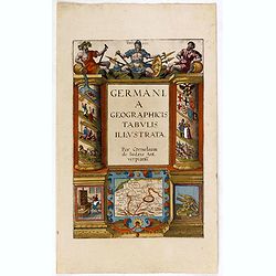
Germania geographicis tabulis illustrata. .
Very rare and beautiful title page from the second edition of Cornelis de Jode rare atlas.
Date: Antwerp, 1593
Selling price: ????
Please login to see price!
Sold in 2015
![[South America] Delineatio omnium orarum totius Australis partis Americae. . .](/uploads/cache/94145-250x250.jpg)
[South America] Delineatio omnium orarum totius Australis partis Americae. . .
A particularly decorative example of Dutch cartography boasting two intricate strapwork cartouches. Exotic animals and bellicose Indians populate the continent, while in ...
Date: Amsterdam, after 1593
Selling price: ????
Please login to see price!
Sold in 2015
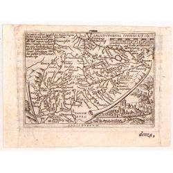
Salisburgensis Jurisdictio.
Minature copperplate map of the region around Salzburg in Austria by Abraham Ortelius. It was published by Plantin for Ortelius's "epotome" in 1593. It was engr...
Date: Antwerp, 1593
Selling price: ????
Please login to see price!
Sold in 2019
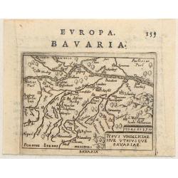
Typus Vindeliciae Sive Utriusque Bavariae.
Charming miniature map of Danube River as it passes through Bavaria. It is from Philip Galle's 1593 Italian edition of the Epitome. Simple title cartouche.
Date: Rome, 1593
Selling price: ????
Please login to see price!
Sold in 2017
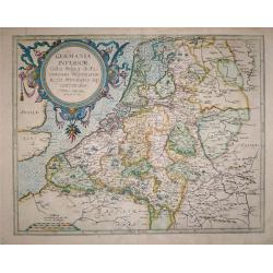
Germania Inferior Gallia, Belgica dicta, continens Hispaniarum Regis Provincias Septentrionalis.
Extremely rare map of Belgium, Luxemburg and the Netherlands from: "Speculum Orbis Terrarum" by Gerard and Cornelis de Jode.In 1578 Gerard de Jode published his...
Date: Antwerp, 1578 - 1593
Selling price: ????
Please login to see price!
Sold in 2016
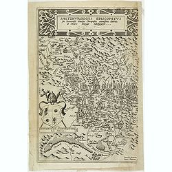
Saltzburgensis episcopatus.
Scarce map of the diocese Salzburg embraces the area between Braunau and Klagenfurt in Austria. The coat of arms belongs to Wolf Dietrich von Raitenau, the bischof of Sal...
Date: Antwerp, 1593
Selling price: ????
Please login to see price!
Sold in 2020
Indiarum Orientalum Occidentaliumoue Descriptio.
World map, with large unexplored ‘Terra Australis’ and westward bulge to South America. Stippled sea with ships and sea monsters. The engraver has copied Ortelius 157...
Date: Cologne, Brickmann, 1593
Selling price: ????
Please login to see price!
Sold in 2017
![Primae Partis Asiae accurata delineatio... [shows Cyprus]](/uploads/cache/97442-250x250.jpg)
Primae Partis Asiae accurata delineatio... [shows Cyprus]
Engraved by the van Deutecum brothers, based upon an earlier map by Gastaldi.0De Jode's rare map of the region, bounded by the Black Sea and Mediterranean in the West, an...
Date: Antwerp, 1593
Selling price: ????
Please login to see price!
Sold in 2017
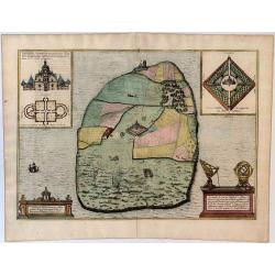
Topographia Insulae Huenae in Celebri Porthmo Regni Daniae, quem vulgo Oersunt Vocant.
Shows the Island of Hven, where Tycho Brahe had his observatory, Uraniborg. Latin text on verso. More about Braun and Hogenberg, Civitatus [+]
Date: Cologne, 1593
Selling price: ????
Please login to see price!
Sold in 2016
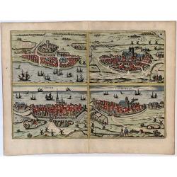
Helsheborch - Lunden - Elbogen - Landeskron.
Decorative bird's eye views of the cities Helsingburg, Lunden, Elbogen and Landeskron. Four city views on one sheet. More about Braun and Hogenberg, Civitatus [+]
Date: Cologne, 1593
Selling price: ????
Please login to see price!
Sold in 2016
Freti Danici or Sundt Accuratiss Delineatio.
Bird's-eye view of The Sound with Helsingborg, Landskrona and Elbogen. Inset with a view of Kronenborg Castle. More about Braun and Hogenberg, Civitatus [+]
Date: Cologne, 1593
Selling price: ????
Please login to see price!
Sold in 2016
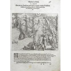
Wie wir zu Honfleur zu Schiff giengen... (Honfleur, Normandy)
The view depicts numerous ships at harbour in Honfleur for loading proviant for their journey to the Americas. From the 3rd book, part 1 of Le Moyne's highly important ac...
Date: Frankfurt, 1593
Selling price: ????
Please login to see price!
Sold in 2016
Oxonium nobile Anglie oppidum...
A decorative view of Oxford, from Braun & Hogenberg's "Civitatus Orbis Theatrum", the most famous atlas of city views published in the 16th Century. A fine ...
Date: Cologne, 1593
Selling price: ????
Please login to see price!
Sold in 2017
TAB. VI ASIAE, Arabiam Felicem, Carmaniam as Sinum Persicum comprehendens.
A Ptolemaic map of the Arabian peninsula. This is the second Mercator edition of the map, which appears for the first time in the 1695 edition of the Ptolemy 'Geographia'...
Date: Antwerp, 1578 - 1593
Selling price: ????
Please login to see price!
Sold in 2018
Lugdunum (Lyon).
A nice, old-colored view of the French city of Lyon, from the first volume of the famous Civitates Orbis Terrarum. A very decorative, large early map of Lyon, that descri...
Date: Antwerp, 1593
Selling price: ????
Please login to see price!
Sold in 2018
Prussiae Regionis Sarmatiae Europae Nobilissimae Novaet vera descriptio . . .
Nice example of the first edition of De Jode's map of Prussia, from the 1593 edition of De Jode's atlas.The present map is an entirely new addition to the second De Jode ...
Date: Antwerp, 1593
Selling price: ????
Please login to see price!
Sold in 2018
![[South America] Delineatio omnium orarum totius Australis partis Americae. . .](/uploads/cache/41496-250x250.jpg)
[South America] Delineatio omnium orarum totius Australis partis Americae. . .
A particularly decorative example of Dutch cartography boasting two intricate strapwork cartouches. Exotic animals and bellicose Indians populate the continent, while in ...
Date: Amsterdam, after 1593
Selling price: ????
Please login to see price!
Sold in 2019
![[Title page] Germania geographicis tabulis illustrata. .](/uploads/cache/42262-250x250.jpg)
[Title page] Germania geographicis tabulis illustrata. .
Very rare and beautiful title page from the second edition of Cornelis de Jode rare atlas. In lower part a map of Germany, Poland and the Low Countries.
Date: Antwerp, 1593
Selling price: ????
Please login to see price!
Sold
![[Untitled.] A Rarity of the Balkans with Fine Original color. Balkans/ Greece/ Istanbul.](/uploads/cache/82204-250x250.jpg)
[Untitled.] A Rarity of the Balkans with Fine Original color. Balkans/ Greece/ Istanbul.
A rare and attractive work with rich, full, original color; one of the earliest atlas maps to focus on Serbia and the lands around the mouth of the Danube. The map also p...
Date: Antwerp, 1593
Selling price: ????
Please login to see price!
Sold in 2019
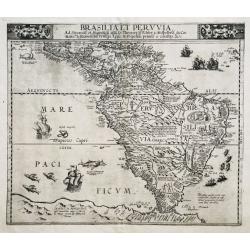
Brasilia et Peruvia.
VERY RARE. THE EARLIEST DUTCH MAP OF SOUTH AMERICA. A nice example of De Jode's important map of South America, based largely upon Petrus Plancius' wall map of the World....
Date: Antwerp, 1593
Selling price: ????
Please login to see price!
Sold in 2020
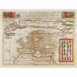
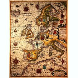
Nova totius Europae tabula.
Very rare map of the continent of Europe, with in top a dedication to Theodor Echter von Mespelbrunn. With an oversized Nova Zemla, including the fictions island "Fr...
Date: Antwerp 1593
Selling price: ????
Please login to see price!
Sold
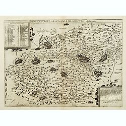
Nova et integra caenomaniae descriptio vulg. Le Mans.
Rare map centered on Le Mans.
Date: Antwerp, 1593
Selling price: ????
Please login to see price!
Sold
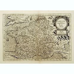
Galliae Amplissimi regni tabula..
Rare map of France.
Date: Antwerp, 1593
Selling price: ????
Please login to see price!
Sold
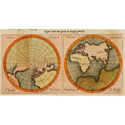
Figure delle Due Specie de Mappi Generali.
On the left hand map, an attractive world view from north pole: the right hand map shows the ancient world including Europe, Africa and Asia: the southern part is mention...
Date: Antwerp, 1593
Selling price: ????
Please login to see price!
Sold
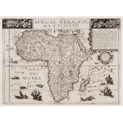
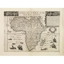
Africae vera forma et situs.
A rare map of the continent of Africa with six sea monsters and four sailing ships decorating the sea and small vignettes of natives, some with bow and arrow, others with...
Date: Antwerp 1593
Selling price: ????
Please login to see price!
Sold
Primae Partis Asiae.
Includes the eastern part of the Mediterranean with Cyprus and Holy Land and the Black Sea with Turkey in between, the northern part of Egypt, Arabia Persia and Afghanist...
Date: Antwerp 1593
Selling price: ????
Please login to see price!
Sold
![[South America] Delineatio omnium orarum totius Australis partis Americae..](/uploads/cache/16740-250x250.jpg)
[South America] Delineatio omnium orarum totius Australis partis Americae..
A particularly decorative example of Dutch cartography boasting two intricate strapwork cartouches. Exotic animals and bellicose indians populate the continent, while in ...
Date: Amsterdam 1593
Selling price: ????
Please login to see price!
Sold
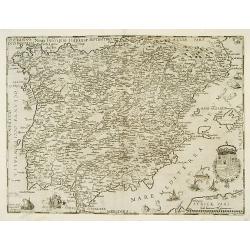
Noua Descriptio Hispaniae..
Very rare and beautifully engraved map from De Jode's atlas Speculum Orbis Terrarum . Detailed map of Spain and Portugal.Engraved by Joan and Lucas van Deutecum.RARE.
Date: Antwerp 1593
Selling price: ????
Please login to see price!
Sold
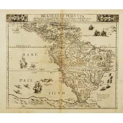
Brasilia et Peruvia.
A rare map of south America and the Caribbean with sea monsters and five sailing ships decorating the sea and small vignettes of natives, some with bow and arrow, others ...
Date: Antwerp 1593
Selling price: ????
Please login to see price!
Sold
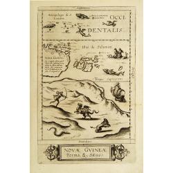
Novae Guineae Forma & Situs.
Extraordinarily rare map of the eastern part of Australia. The first separate map of this continent ever printed.The map appeared in the 2nd edition of De Jode's rare Spe...
Date: Antwerp 1593
Selling price: ????
Please login to see price!
Sold
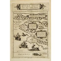
Quivirae Regnv cum alijs versus Borea.
Extraordinarily rare map, the first published map devoted to the west and north-west coasts of North America.The map not only conveys the early cartographic view of the N...
Date: Antwerp 1593
Selling price: ????
Please login to see price!
Sold
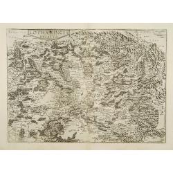
Lotharingia ducatus.
Very rare and beautifully engraved map from De Jode's atlas Speculum Orbis Terrarum . Detailed map of Lorraine.Engraved by Joan and Lucas van Doetecom.RARE.
Date: Antwerp 1593
Selling price: ????
Please login to see price!
Sold
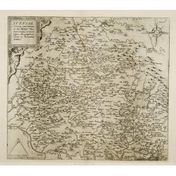
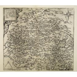
Sueviae.
Very rare and beautifully engraved map from De Jode's atlas Speculum Orbis Terrarum . Detailed map of region of Ulm, Strasbourg, Bodensee.Engraved by Joan and Lucas van D...
Date: Antwerp 1593
Selling price: ????
Please login to see price!
Sold
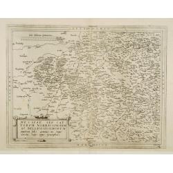
Hessiae seu cattorum noblissimorum ac Bellicosissimorum ..
Very rare and beautifully engraved map from De Jode's atlas Speculum Orbis Terrarum . Detailed map of the regions east and west of the river Fulga.Engraved by Joan van Do...
Date: Antwerp 1593
Selling price: ????
Please login to see price!
Sold
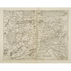
Typus Corographicus Veromanduae.. / Sabaudiae ducatus..
Very rare and beautifully engraved map from De Jode's atlas Speculum Orbis Terrarum . Detailed map of regions along the river Saône River, including Lyon.Engraved by Joa...
Date: Antwerp 1593
Selling price: ????
Please login to see price!
Sold
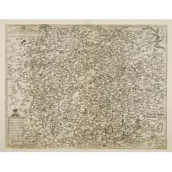
Bavariae utriusque cum in ferioris vera..
Very rare and beautifully engraved map from De Jode's atlas Speculum Orbis Terrarum . Detailed map of southern Germany, with Augsburg, Regensburg, Munich, etc.Engraved by...
Date: Antwerp 1593
Selling price: ????
Please login to see price!
Sold
![[South America] Delineatio omnium orarum totius Australis partis Americae..](/uploads/cache/21304-250x250.jpg)
[South America] Delineatio omnium orarum totius Australis partis Americae..
A particularly decorative example of Dutch cartography boasting two intricate strapwork cartouches. Exotic animals and bellicose indians populate the continent, while in ...
Date: Amsterdam 1593
Selling price: ????
Please login to see price!
Sold
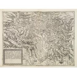
Helvetiae seu Sviciae qvae mvltis confoederatvm..
A rare and beautifully engraved map from the second edition of De Jode's atlas Speculum Orbis Terrarum . Includes complete Switzerland.Engraved by Joan and Lucas van Deut...
Date: Antwerp 1593
Selling price: ????
Please login to see price!
Sold
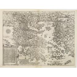
Videbis totius Grecia
Very rare and beautifully engraved map from De Jode's atlas Speculum Orbis Terrarum . Detailed map of Greece.In 1578, Gerard De Jode published his atlas entitled Speculum...
Date: Antwerp 1593
Selling price: ????
Please login to see price!
Sold
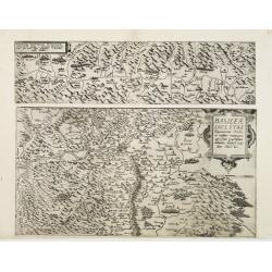
Basileae Inclytae Rauracorum Urbis.. / Valesiae Provinciae montanae Italiam.
Two maps on one sheet: in top the canton Valais and in bottom part a detailed map of the area around Basel.Very rare and beautifully engraved map from De Jode's atlas Spe...
Date: Antwerp 1593
Selling price: ????
Please login to see price!
Sold
Africae vera forma ey situs.
A rare map of the continent of Africa with six sea monsters and four sailing ships decorating the sea and small vignettes of natives, some with bow and arrow, others with...
Date: Antwerp 1593
Selling price: ????
Please login to see price!
Sold
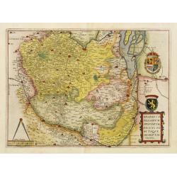
Brabantiae Belgarum Provinciae recens. . .
Based on a map by Jacob van Deventer, by order of King Charles V. Jacob van Deventer was one of the first cartographers of the Southern Netherlands. He was famous for his...
Date: Antwerp, 1593
Selling price: ????
Please login to see price!
Sold
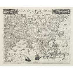
Asia partium Orbis Maxima.
A superb decorative map of Asia which is exceptionally rare since it only appeared in the second edition of de Jode's Speculum. The Asian coast is straight south-west to ...
Date: Antwerp, 1593
Selling price: ????
Please login to see price!
Sold
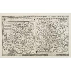
Turingiae Comitatus Provincialis - Misniae Marchionatus
2 maps on one plate depicting the German states of Thüringen and Saxony. Centered respectively on Erfurt and Dresden.Gerard De Jode was the great rival of Ortelius, both...
Date: Antwerp, 1593
Selling price: ????
Please login to see price!
Sold
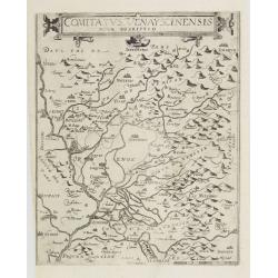
Comitatus Venayscinensis Nova Discriptio.
Rare map depicting part of Provence with Avignon, Cavaillon, Orange, Carpentras, etc.Gerard De Jode was the great rival of Ortelius, both made a living out of selling map...
Date: Antwerp, 1593
Selling price: ????
Please login to see price!
Sold in 2008
Sueviae utriusq cum Germaniae tum Rhetiae. . .
Very rare and beautifully engraved map from De Jode's atlas Speculum Orbis Terrarum . Detailed map of region of Ulm, Strasbourg, Bodensee.Engraved by Joan and Lucas van D...
Date: Antwerp, 1593
Selling price: ????
Please login to see price!
Sold in 2013
Theatrum Terrae Sanctae et Biblicarum Historiarum. Cum tabulis geographicis aere expressis
Second edition of the work about Palestine by Delft theologian Christian Adrichomius, first published 1590. With a Geography of Palestine, a description of Jerusalem and ...
Date: Cologne, 1593
Selling price: ????
Please login to see price!
Sold in 2009