Browse Listings
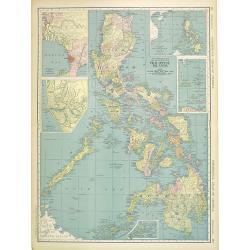
Philippine Islands.
Map of the Philippines, with insets of Manila, Manila vicinity, Sulu Archipelago, China Sea and Batan Islands. The shipping routes between the main cities are printed in ...
Date: Chicago & New York, 1895
Selling price: ????
Please login to see price!
Sold in 2014

Paris fashion plate. (3248)
Uncommon Paris fashion plate from Le Moniteur de la Mode, under direction of Abel Goubaud.In the later quarter of the 19th century there was a proliferation of women's ma...
Date: Paris, 1896
Selling price: ????
Please login to see price!
Sold in 2023

Paris fashion plate. (3281)
Uncommon Paris fashion plate from Le Moniteur de la Mode, under direction of Abel Goubaud.In the later quarter of the 19th century there was a proliferation of women's ma...
Date: Paris 1896
Selling price: ????
Please login to see price!
Sold in 2011
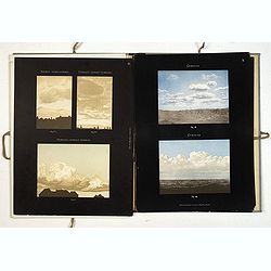
Atlas international des nuages. International cloud-atlas. Internationaler wolken-atlas.
FIRST EDITION. Title in French, English and German. The first edition consisted of plates of color photographs, which was then a new technology."In 1874, the year of...
Date: Paris, Gauthier-Villars et fils, 1896
Selling price: ????
Please login to see price!
Sold
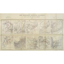
Carte d'Ensemble des Principaux Districts Aurifères (autre que le district aurifère de Witwatersrand) situés dans les pays Sud africains.
Ten inset maps of the main auriferous districts located in various South African countries. A key in upper left and right hand corner. The places with gold mines are indi...
Date: Paris, Monroqo, 1896
Selling price: ????
Please login to see price!
Sold in 2010
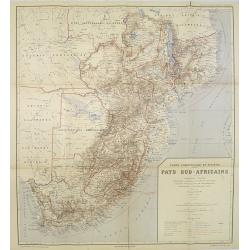
Carte Commerciale et Minière Pays Sud-Africains.
General trade and gold mine map of South Africa.In upper right corner "Carte Commerciale et Minière des Pays Sud-Africains No. 1".Prepared by F. Bianconi. With...
Date: Paris, Monroqo, 1896
Selling price: ????
Please login to see price!
Sold in 2010
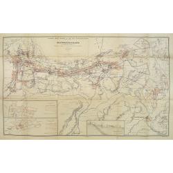
Carte des Mines d'Or en exploitation dans le district de Witwatersrand (Transvaal) . . .
Gold mine map situated in the Witwatersrand district with 2 inset maps of New-Primrose and Buffelsdoorn Estate. Also a transverse section of a gold mining extraction mill...
Date: Paris, Monroqo, 1896
Selling price: ????
Please login to see price!
Sold in 2018

Napoleon.
An engraving on Vellum of Napoleon AFTER MEISSONIER by Albert Ardabil. This is an original and rare etching by Albert Ardail signed in pencil Alb Ardail lower right margi...
Date: London, 1896
Selling price: ????
Please login to see price!
Sold in 2013
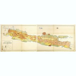
Geologische overzichtskaart van Java en Madoera in 12 bladen schaal 1: 500.00
Scarce geological map of Java and Madoera in a scale of 1:500.000 printed by Rogier Diederik Marius Verbeek (1845-1926) and Rinder Fennema (1849-1926). This is the rare w...
Date: Amsterdam, 1896
Selling price: ????
Please login to see price!
Sold in 2016
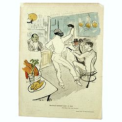
Chocolat dansant dans un bar.
"The Irish and American Bar was described as an English bar where truly hardened drinkers would silently sit lost in contemplation of the bottles. The barman (seen s...
Date: Paris, 1896
Selling price: ????
Please login to see price!
Sold in 2019

A Gaety Girl.
Chromo lithographed poster, "A Gaety Girl.", after Dudley Hardy, D. Plate 4, published in 1896. The "Les Maitres de l'Affiche" contained 256 small for...
Date: Paris, Imprimerie Chaix, 1896
Selling price: ????
Please login to see price!
Sold in 2017
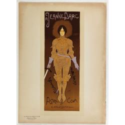
Jeanne d'Arc.
Chromo lithographed poster, "Jeanne d'Arc.", by DE FEURE, G. Plate 130, published in Maître 17, on April 1896. The "Les Maîtres de l'Affiche" contai...
Date: Paris, Imprimerie Chaix, April 1896
Selling price: ????
Please login to see price!
Sold in 2018
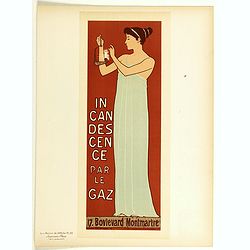
Incandescence par le gaz.
Chromo lithographed poster of Les Maîtres de l'Affiche being plate n°23. The "Les Maîtres de l'Affiche" contained 256 small for lithographic prints of the be...
Date: Paris, Imprimerie Chaix, 1896
Selling price: ????
Please login to see price!
Sold in 2018

A Gaiety girl.
Cover binder of Les Maîtres de l'Affiche n°4. The "Les Maîtres de l'Affiche" contained 256 small for lithographic prints of the best posters of the Belle Ép...
Date: Paris, Imprimerie Chaix, 1896
Selling price: ????
Please login to see price!
Sold in 2018
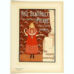
Pate dentifrice du Docteur Pierre . . .
Chromo lithographed poster of Les Maîtres de l'Affiche being plate n°26. The "Les Maîtres de l'Affiche" contained 256 small for lithographic prints of the be...
Date: Paris, Imprimerie Chaix, 1896
Selling price: ????
Please login to see price!
Sold

Harper's in the largest and most popular magazine . . .
Chromo lithographed poster of Les Maîtres de l'Affiche being plate n°16. The "Les Maîtres de l'Affiche" contained 256 small for lithographic prints of the be...
Date: Paris, Imprimerie Chaix, 1896
Selling price: ????
Please login to see price!
Sold in 2018

Cycles Le Chevreuil . . .
An impressive advertising poster for 'Cycles Le Chevreuil', made by Pean René. René Louis Péan, was born in Paris on July 1, 1875, and died in Ermont on September 4, 1...
Date: Paris, 1896
Selling price: ????
Please login to see price!
Sold
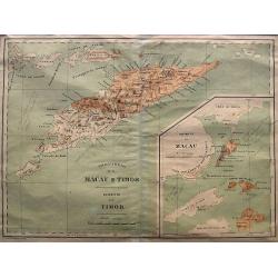
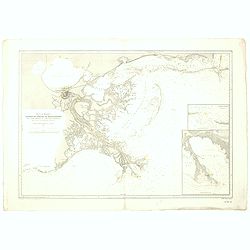
Provincia de Macau e Timor
A very rare map published by Companhia Nacional Editora ca. 1895. It shows the Portuguese colonies Timor and Macao in great detail. From 1844 until 1895 Timor was integra...
Date: Lisbon, ca. 1896
Selling price: ????
Please login to see price!
Sold in 2021
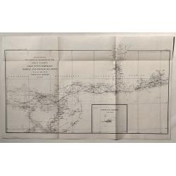
Sketch Showing Progress of Surveys on the Gulf Coast Lake Pontchartrain, Mobile and Pensacola Bays.
This is the Survey Report of 1896 by the U.S. Coast and Geodetic Department. It includes an insert of Tortugas Harbor.
Date: Washington, 1896
Selling price: ????
Please login to see price!
Sold in 2020
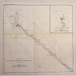
Boundary Survey Between California and Nevada.
An antique lithographic map published in 1896, Washington for "U.S. Coast and Geodetic Survey" . Includes an insert “SUB SKETCH OF SOUTHERN END OF BOUNDARY�...
Date: Washington, 1896
Selling price: ????
Please login to see price!
Sold in 2020
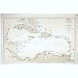
Título: Carta General del Mar de las Antillas : segun los trabajos mas fidedignos nacionales y extrangeros / publicada de Órden del Almirantazgo por la Seccion de Hidrografía. . .
Rare Spanish sea chart of the Caribbean and the coasts of Mexico, Honduras, Nicaragua, Panama, Costa Rica, Colombia and Venezuela. Graduated margins. Meridian of origin: ...
Date: Madrid , 1897
Selling price: ????
Please login to see price!
Sold in 2020
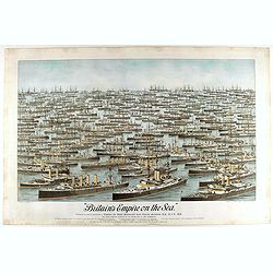
Britain's Empire on the Sea. Dedicated to Captain the Right Honourable Lord Charles Beresford...
A very decorative and large chromolithographed plate showing all the effective strength of the British navy with the name and class of each ship shown beneath, except for...
Date: Portsea, ca. 1897
Selling price: ????
Please login to see price!
Sold in 2025

Study of two Horses.
Unfinished study plate by Pieter Dupont(1870-1911).Printed by E.J. van Wisselingh in Amsterdam, with a total of 50 copies. cat. Nr. 341. with atelierstamp "Atelier P...
Date: Paris, 1897
Selling price: ????
Please login to see price!
Sold in 2008
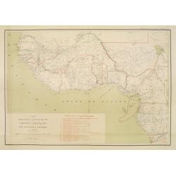
Carte des Missions .. Du Soudan Français..
Uncommon and detailed map of Western part of Africa, prepared by P.Vuillot. The map has a key to the 19 different missionary territories. Published as a supplement to Jou...
Date: Lyon/Paris 1897
Selling price: ????
Please login to see price!
Sold

Salomé.
A half-length woman playing a peculiar circular lyre,Original lithograph plate from 'L'Estampe moderne', Vol. 1, no. 3, July 1897, as a premium plate for purchasers of on...
Date: Paris, July 1897
Selling price: ????
Please login to see price!
Sold
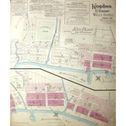
Kingston, St. Vincent. West Indies.
Large, uncommon fire insurance plan is presented on a scale of 120 feet to one inch. Lists the town with a population of 6000, from which 1/12 is white. Explains the main...
Date: Montreal/Toronto, 1897
Selling price: ????
Please login to see price!
Sold in 2014
![[Map of South Africa]](/uploads/cache/33440-250x250.jpg)
[Map of South Africa]
Lithographic map of South Africa. With label of map seller E. Andriveau-Goujon, Rue le Bac, Paris.
Date: Paris, 1897
Selling price: ????
Please login to see price!
Sold in 2013
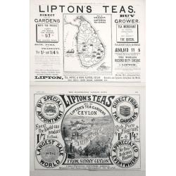
Map of Ceylon shewing Lipton's Tea Estates.
Two Adverts for Lipton's Tea the first one has a map of Ceylon showing their estates on the Island set in advertising text dated December 25th 1897, The second is an adve...
Date: London, 1897
Selling price: ????
Please login to see price!
Sold in 2014
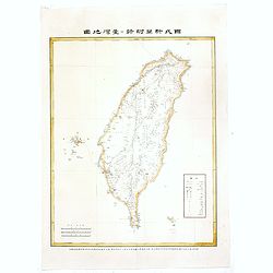
(Map of Taiwan with Chinese characters)
Map of Taiwan with Chinese text, printed during Taiwan under Japanese rule. With a scale in lower left corner and a key to road, towns, villages and rail road system.Bott...
Date: Tokyo, 28th year of Meiji or 1897
Selling price: ????
Please login to see price!
Sold in 2016
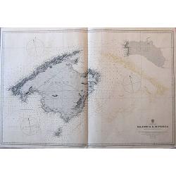
Balearic Islands Majorca & Minorca from Spanish government surveys, 1890-3.
A large sea-chart of Mallorca, Menorca, and Cabrera, published in 1897, with the magnetic variation for 1900. It gives many place names along the coasts, and some informa...
Date: London, 1897
Selling price: ????
Please login to see price!
Sold in 2017
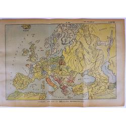
L'Europe vue par un aeronaute impressionnable.
A rare satirical map of Europe, published in the French magazine Le Pélerin N° 1054 on March 14th, 1897. color printed, with French text on verso.More about cartographi...
Date: Paris, 1897
Selling price: ????
Please login to see price!
Sold in 2017
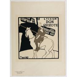
Lyceum Don Quixote.
Chromo lithographed poster, "Lyceum Don Quixote.", Plate 63, published in Maître 16, on March 1897. Signed in the plate with signature of "The Beggarstaff...
Date: Paris, Imprimerie Chaix, April 1897
Selling price: ????
Please login to see price!
Sold in 2017
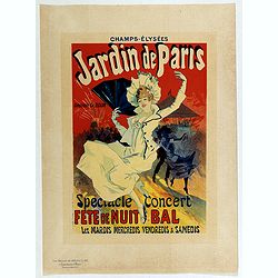
Champs Elysées, jardin de Paris.
Chromo lithographed poster, "Champs Elysées, jardin de Paris.", by CHERET, J. Plate 65, published in Maître 17, on April 1897. The "Les Maîtres de l'Aff...
Date: Paris, Imprimerie Chaix, April 1897
Selling price: ????
Please login to see price!
Sold
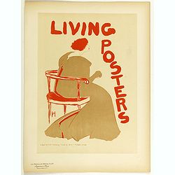
Living posters
Chromo lithographed poster of Les Maîtres de l'Affiche being plate n°87. The "Les Maîtres de l'Affiche" contained 256 small for lithographic prints of the be...
Date: Paris, Imprimerie Chaix, 1897
Selling price: ????
Please login to see price!
Sold in 2018
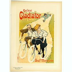
Cycle's Gladiator.
Chromo lithographed poster of Les Maîtres de l'Affiche being plate n°86. The "Les Maîtres de l'Affiche" contained 256 small for lithographic prints of the be...
Date: Paris, Imprimerie Chaix, 1897
Selling price: ????
Please login to see price!
Sold in 2021
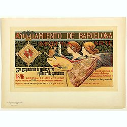
Ayuniamiento de Barcelona . . .
Chromo lithographed poster of Les Maîtres de l'Affiche being plate n°64. The "Les Maîtres de l'Affiche" contained 256 small for lithographic prints of the be...
Date: Paris, Imprimerie Chaix, 1897
Selling price: ????
Please login to see price!
Sold in 2018

The Gay Parisienne.
Chromo lithographed poster of Les Maîtres de l'Affiche being plate n°96. The "Les Maîtres de l'Affiche" contained 256 small for lithographic prints of the be...
Date: Paris, Imprimerie Chaix, 1897
Selling price: ????
Please login to see price!
Sold
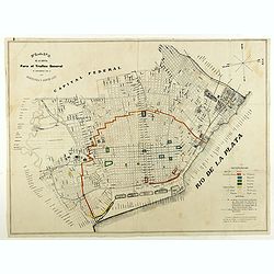
Plano de la capital para el trafico general de conformidad con la ordenanza 3 Agosto 1897.
City plan of Buenos Ayres in August 1897. With a color key in lower right corner.
Date: Italy, 1897
Selling price: ????
Please login to see price!
Sold in 2018
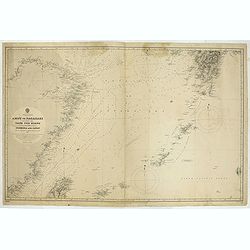
China & Japan - Amoy to Nagasaki including the Yang Tse Kiang and the Islands between Formosa and japan..
Large chart centered on the East Sea between China and Japan. In upper right corner tip of island of Kyushu. Lower left northern tip of Taiwan, and in center Okinawa. Som...
Date: London, 1891, updates to 1897
Selling price: ????
Please login to see price!
Sold in 2021
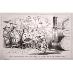
A set of 11 humorous prints with China interest.
This set of 11 are from 1853 - 1898. Mostly engraved by Joseph Swain. Joseph Swain was one of the most important woodblock engravers.Punch was responsible for the word se...
Date: 1853 - 1898
Selling price: ????
Please login to see price!
Sold in 2016
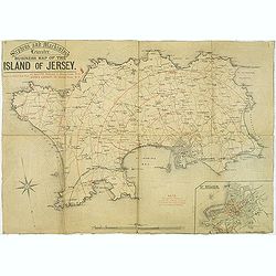
Stephens and Mackintosh Leicester. Business map of the island of Jersey.
Map of Jersey. it shows the principal roads, plus street plan St. Helier inserted in the lower right corner. Showing the distance from St. Helier in red among a key to ab...
Date: Leicester, ca. 1898
Selling price: ????
Please login to see price!
Sold in 2019
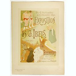
Exposition à la Bodiniére . . .
Chromo lithographed poster, "Exposition à la Bodiniére . . .", by IBELS, H.G. Plate 138, published in Maître 17, on April 1898. The "Les Maîtres de l'A...
Date: Paris, Imprimerie Chaix, April 1898
Selling price: ????
Please login to see price!
Sold
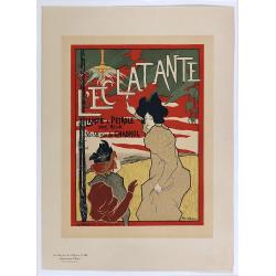
L'Eclatante lampe à pétrole sans mêche.
Chromo lithographed poster, "L'Eclatante lampe à pétrole sans mêche.", by ROBBE, M. Plate 143, published in Maître 17, on April 1898. The "Les Maîtres...
Date: Paris, Imprimerie Chaix, April 1898
Selling price: ????
Please login to see price!
Sold

Salon des Cent . . .
Chromo lithographed poster of Les Maîtres de l'Affiche being plate n°98. The "Les Maîtres de l'Affiche" contained 256 small for lithographic prints of the be...
Date: Paris, Imprimerie Chaix, 1898
Selling price: ????
Please login to see price!
Sold
Sound et delta du Mississippi / de la baie de Mobile à la Nouvelle Orléans d'après les Cartes de l'United Coast Survey...
A fine French Service Hydrograhique de la Marine chart no.4710, showing the Mississippi Delta from Mobile Bay to New Orleans, after maps of the United Coast Survey. With ...
Date: Paris, 1894 / 1898
Selling price: ????
Please login to see price!
Sold in 2019
Guerre Hispano-Américaine.. Carte de Cuba, des petites Antilles et des Iles Philippines.
Interesting map of North and Central America. In upper right corner: 2e édition Revue et Completée. Text on verso relating to the history of Cuba Histoire de Cuba depui...
Date: Gent , 1898
Selling price: ????
Please login to see price!
Sold
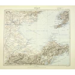
Pékin. Techeng-te-fou.
Very detailed (1:1.000.000) map with Peking (Beijing) in the upper left corner, and centered on Tianjin, showing soundings, Russian, German and Chinese.The French Service...
Date: Paris, 1898
Selling price: ????
Please login to see price!
Sold in 2010
![Battle of Magersfontein. [Situation about Noon].](/uploads/cache/45357-250x250.jpg)
Battle of Magersfontein. [Situation about Noon].
[Map no.7] The Battle of Magersfontein was fought on 11 December 1899, at Magersfontein near Kimberley, South Africa, on the borders of the Cape Colony and the independen...
Date: Edinburgh / London, 1899
Selling price: ????
Please login to see price!
Sold in 2021
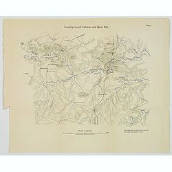
Country round Cloenso and Spion Kop.
[Map no.4] The Battle of Colenso was the third and final battle fought during the Black Week of the Second Boer War. It was fought between British and Boer forces from th...
Date: Edinburgh / London, 1899
Selling price: ????
Please login to see price!
Sold in 2021
![Action at Elandslaagte [Situation about 5pm].](/uploads/cache/45360-250x250.jpg)
Action at Elandslaagte [Situation about 5pm].
[Map no.3] The Battle of Elandslaagte was a battle of the Second Boer War, and one of the few clear-cut tactical victories won by the British during the conflict. However...
Date: Edinburgh / London, 1899
Selling price: ????
Please login to see price!
Sold in 2021
![[Africa].](/uploads/cache/46143-250x250.jpg)
[Africa].
A detailed map of Africa published by the very successful St. Petersburg publisher "Cartographic institution A.Ilina".Alexey Afinogenovich Ilyin was a lieutenan...
Date: St. Petersburg, 1899
Selling price: ????
Please login to see price!
Sold in 2020
![[Italy and Spain/ Portugal].](/uploads/cache/46146-250x250.jpg)
[Italy and Spain/ Portugal].
Alexey Afinogenovich Ilyin was a lieutenant general and cartographer (1832-1889). In 1856, after graduating from the Academy of the General Staff, he was at the military ...
Date: St. Petersburg, 1899
Selling price: ????
Please login to see price!
Sold in 2023
![[World map].](/uploads/cache/46148-250x250.jpg)
[World map].
A word map with a color key showing different racial classifications published by the very successful St. Petersburg publisher "Cartographic institution A.Ilina"...
Date: St. Petersburg, 1899
Selling price: ????
Please login to see price!
Sold in 2020
![[Gulf stream map].](/uploads/cache/46150-250x250.jpg)
[Gulf stream map].
A detailed Gulf Stream map published by the very successful St. Petersburg publisher "Cartographic institution A.Ilina" Alexey Afinogenovich Ilyin was a lieut...
Date: St. Petersburg, 1899
Selling price: ????
Please login to see price!
Sold in 2022
![[Mont-Blanc].](/uploads/cache/46165-250x250.jpg)
[Mont-Blanc].
A detailed map cantered on the Mont Blanc and its vicinities published by the very successful St. Petersburg publisher "Cartographic institution A.Ilina".Alexey...
Date: St. Petersburg, 1899
Selling price: ????
Please login to see price!
Sold in 2022
![[Greece].](/uploads/cache/46170-250x250.jpg)
[Greece].
A detailed map of Greece published by the very successful St. Petersburg publisher "Cartographic institution A.Ilina".Alexey Afinogenovich Ilyin was a lieutenan...
Date: St. Petersburg, 1899
Selling price: ????
Please login to see price!
Sold in 2020
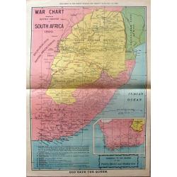
War Chart Showing the Battle Ground in South Africa, 1899.
Fine large map showing the battleground of the South African wars. It has an insert of Cape Colony & the Orange Free State. It was a supplement in "THE FAMILY HE...
Date: South Africa, 1899
Selling price: ????
Please login to see price!
Sold in 2015
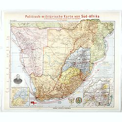
Politisch-militarische Karte von Sud-Afrika zur Veranschaulichung der Kampfe zwischen Buren und Englandern bis zur Gegenward (Large inset map of Goldfelder in Transvaal)
Finely executed map illustrating the progress of the war between the English and the Boers, published by Justus Perhes in 1899.The map includes a tremendous amount of top...
Date: Gotha, 1899
Selling price: ????
Please login to see price!
Sold in 2016
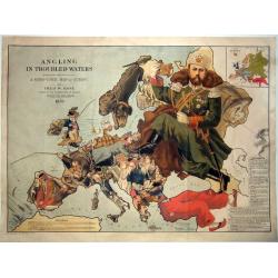
Angling in Troubled Waters A Serio-Comic Map of Europe by Fred. W. Rose Author of the 'Octopus Map of Europe' 1899.
One of the most famous serio-comic maps. A chromolithographed large caricature map of Europe with each country depicted as an angler having various levels of success in h...
Date: London, 1899
Selling price: ????
Please login to see price!
Sold in 2021
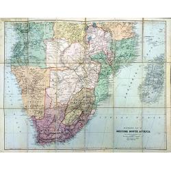
Stanford's Map of British South Africa.
A detailed folding map of South Africa in original red covers. Revised to May 1st, 1899. Stanford's map depicts the most up-to-date mapping of the region at the turn of t...
Date: London, 1899
Selling price: ????
Please login to see price!
Sold in 2018
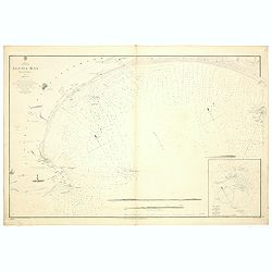
Africa south east Algoa Bay by Lieut Joseph Dayman RN assisted by Lieut HG Simpson RN 1855.
A fine Hydrographic Office chart no. 642 (2191), showing the coast of Algoa Bay with Port Elisabeth and Cape Recife. With three coastal profiles, a lighthouse and one ins...
Date: London, 1856 / 1899
Selling price: ????
Please login to see price!
Sold in 2019
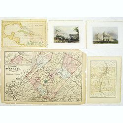
Group of 5 maps and prints of North American interest.
Group of five prints and maps. - Map of the West Indies by W.Darton.- View of New York from Weehawken by W.H.Bartlett (120x180mm.)- Principal front of the capitol Washing...
Date: c. 1850-1900
Selling price: ????
Please login to see price!
Sold in 2014
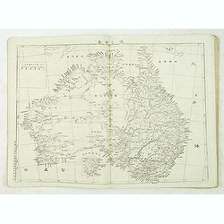
Chinese School world atlas.
School world atlas containg two world maps in double hemisphere and Mercator projection and maps of all parts of the world. Good section on maps of Australia and Pacific.
Date: Beijing, ca.1900
Selling price: ????
Please login to see price!
Sold in 2012
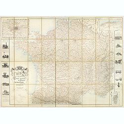
Carte routière de France de Dion Bouton spéciale pour automobiles.
Highly decorative folding wall map of France in a scale of 1 : 800 000. In the upper left hand corner an inset plan of Paris, upper right Algeria and lower right map of C...
Date: Paris, J. Barreau, no date, circa 1900
Selling price: ????
Please login to see price!
Sold in 2014

Le départ.
A 1900's restrike of this fine plate by Carle Vernet (actually Antoine Charles Horace, Bordeaux 1758 – Paris 1836). Aquatint by Louis Philibert Debucourt (1755 Paris 18...
Date: Paris, 1820 restrike of ca.1900
Selling price: ????
Please login to see price!
Sold in 2014
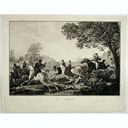
La Chasse.
A 1900's restrike of this fine plate by Carle Vernet (actually Antoine Charles Horace, Bordeaux 1758 – Paris 1836). Aquatint by Louis Philibert Debucourt (1755 Paris 18...
Date: Paris, 1820 restrike of ca.1900
Selling price: ????
Please login to see price!
Sold in 2014
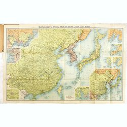
Bartholomew's New map of China and the East.
A fine map of the Far East, including, China, Korea, Japan, with 6 insets of Seoul, Peking, Hong-Kong, Nagasaki, Tokyo, Port Arthur, Vladivostok, entitiled: "Barthol...
Date: Edinburg, ca. 1895-1900
Selling price: ????
Please login to see price!
Sold in 2017
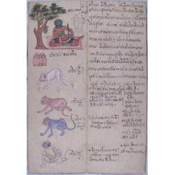
(Thai manuscript describing the signs of the Zodiac)
Old sheet with manuscript on both sides, text and illustrations. With the characteristics of the year of the monkey.Unique and curious item!
Date: undated, c1900
Selling price: ????
Please login to see price!
Sold in 2015
![[Two Neapolitan Gouaches.]](/uploads/cache/94508-250x250.jpg)
[Two Neapolitan Gouaches.]
2 beautifully detailed c1900 Neapolitan gouaches, showing the Bay of Naples and Mount Vesuvius.Overall size of cardboard 22 x 36,5 cm each; image size each see below. 'Go...
Date: Naples, ca. 1900
Selling price: ????
Please login to see price!
Sold in 2016
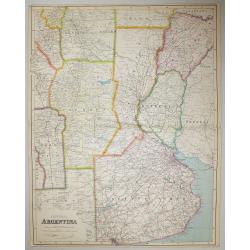
Central Argentina.
A large scale map of Argentina by George Philip & Son The map shows provincial boundaries, and is very high in contemporary detail.Published in London for The London ...
Date: London, 1900
Selling price: ????
Please login to see price!
Sold in 2016
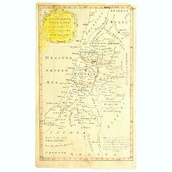
An accurate map of the Holy-Land as when traveling over by our saviour and his apostles.
An unusual manuscript map of the Holy-Land as when travelling over by Jesus and his apostles.
Date: ca. 1900
Selling price: ????
Please login to see price!
Sold in 2017
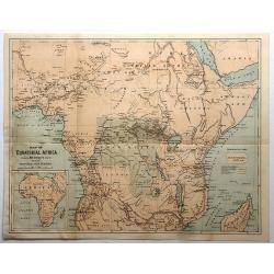
Map of Equitorial Africa Showing Mr. Stanley's Route and All His Principal Discoveries.
A chromo-lithograph map from an unknown book featuring the Welsh reporter Sir Henry M. Stanley's quest to find Dr. David Livingstone, a Scottish missionary presumed lost...
Date: New York, ca. 1900
Selling price: ????
Please login to see price!
Sold in 2017
![[Hackney from Booth's Poverty Map of London]](/uploads/cache/40266-250x250.jpg)
[Hackney from Booth's Poverty Map of London]
A map of the London Borough of Hackney, one section (of twenty) of an extended version of the incredibly influential Poverty Map, originally published in Charles Booth's ...
Date: London, 1900
Selling price: ????
Please login to see price!
Sold in 2017
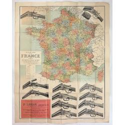
Nouvelle Carte de la France Indiquant les Routes, les Chins de Fer les Stations Thermales et Balneaires D'Apres les Documents les Plus Recents
A fascinating large map of France with the advertising of Browning shotguns. It was produced in Paris ca. 1900. Twelve shotguns are featured with their prices at the time...
Date: Paris ca. 1900
Selling price: ????
Please login to see price!
Sold in 2017
![[Les anciennes provinces Françaises à la ville de Saint Denis].](/uploads/cache/41682-250x250.jpg)
[Les anciennes provinces Françaises à la ville de Saint Denis].
Nine small chromolithography's trade cards for Ville de Saint Denis, each with French regions and places, with description in French on each verso.Cards of the regions : ...
Date: Paris, circa 1900
Selling price: ????
Please login to see price!
Sold in 2018
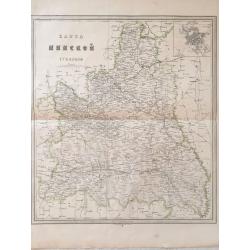
Map of Minsk gubernia.
Карта Минской губ&am...
Date: Sankt Peterburg, 1850-1900
Selling price: ????
Please login to see price!
Sold in 2018
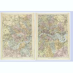
London West / East.
A detailed pair of plans of London, as it was at the turn of the last century. Different areas are multi colored. With rich detail that includes; many major roads and tho...
Date: London, ca 1900
Selling price: ????
Please login to see price!
Sold in 2019
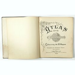
Atlas de Filipinas. Trabajados por delineantes filipinos. . .
First separately published atlas of the Philippine Islands. These detailed maps of the Philippine Islands were developed by Jesuits over many years and published by Treas...
Date: Washington, 1900
Selling price: ????
Please login to see price!
Sold in 2018
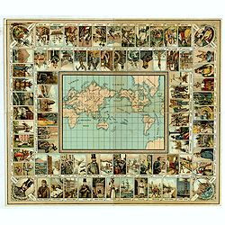
Reise um die Welt in achtzig Tagen. Nach dem Roman von J. Verne. Ein unterhaltendes Gesellschaftsspiel.
Travel around the world in eighty days. After the novel by Jules Verne. An entertaining dice game with 80 fields, in the middle a world map. Title after the tutorial. Nei...
Date: Germany, ca. 1900
Selling price: ????
Please login to see price!
Sold in 2022
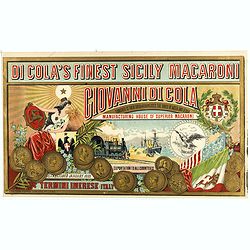
Di Cola's finest Sicily macaroni.
Very decorative mini poster for macaroni by Di Cola. According to the text being the finest Sicily macaroni and furnisher to their Royal Highnesses the Dukes of Aost and ...
Date: Palermo, 1895 - 1900
Selling price: ????
Please login to see price!
Sold in 2019