Browse Listings
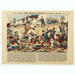
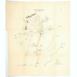
Guerre du Tonkin. Défense héroïque de Tuyen-Quan, du 14 février au 3 mars 1885. (N°165)
Broad sheet relating to The Siege of Tuyen Quang which was an important confrontation between the French and the Chinese armies in Tonkin (northern Vietnam) during the Si...
Date: Epinal, ca. 1900
Selling price: ????
Please login to see price!
Sold in 2019
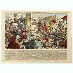
Le siège des léfations Européennes a Pekin (20 juin - 15 août 1900) - (N°186)
Broad sheet relating to The Battle of Peking, or historically the Relief of Peking, was the battle on 14–15 August 1900, in which a multi-national force, led by Britain...
Date: Epinal, ca. 1900
Selling price: ????
Please login to see price!
Sold in 2020
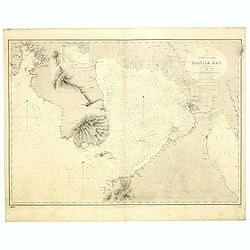
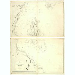
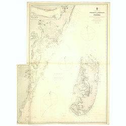
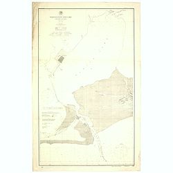
Philippines. Luzon Island/ Manila Bay / Surveyed by the Spanish Philippine Hyde. Commission under the direction of Captain Claudio Montero 1861.
Detailed chart of the Bay of Manilla based upon the Spanish Philippine Hydrographical surveys under the direction of Captain D. Claudio Montero in 1861. Some additional l...
Date: London, 1861 / c.1900
Selling price: ????
Please login to see price!
Sold in 2019
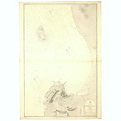
Africa - SW coast Table Bay surveyed by Mr F Skead Master RN assisted by Mr Charles Watermeyer 1858-60.
A fine Hydrographic Office chart no. 1920 (2179) showing Table Bay and Cape Town. With a reference key to Cape Town : a-v, indication of Magnetic Variation in 1900 and of...
Date: London, 1858-60/ c.1900
Selling price: ????
Please login to see price!
Sold in 2019
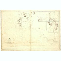
Africa - south coast sheet I Cape Colony Table Bay to Cape Agulhas compiled from the surveys of Lieut Joseph Dayman 1853 Francis Skead Master 1860 and Navigating Lieutenant W E Archdeacon RN 1869... Purey-Cust RN... Rambler 1900.
A fine Hydrographic Office chart no. 2082 (2177) showing Table Bay to Agulhas. With indication of Magnetic Variation in 1883 and of fixed and flashing lights. Chart with ...
Date: London, 1858-60/ Nov.r 1900
Selling price: ????
Please login to see price!
Sold in 2019
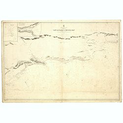
Africa south coast sheet II Cape Colony Cape Agulhas to Mossel Bay compiled from the surveys of Lieutenant J Dayman 1867.
A fine Hydrographic Office chart no. 2083 (2185), showing Cape Agulhas to Mossel Bay. Engraved by E. Standford. London : Published at the Admiralty 16th Sept.r 1867 under...
Date: London, 1858-1860/1900
Selling price: ????
Please login to see price!
Sold in 2019
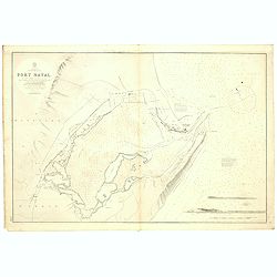
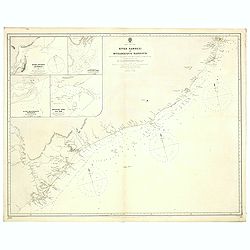
Africa. South East Coast. Port Natal. By lieutenants J. Dayman & H.G. Simpson, R.N., 1854. Additions by Navigating Lieutenant W.E. Archdeacon, R.N. 1872, and by Sir John Coode, C.E., 1877.
A fine Hydrographic Office chart no. 643 (2199), showing Durban formerly Port Natal. Engraved by J. & C. Walker. London : Published at the Admiralty 23rd August 1856 ...
Date: London, 1854 / 1900
Selling price: ????
Please login to see price!
Sold in 2019
![Africa east coast Tugela river to Delagoa Bay surveyed by Captain Pelham Aldrich assisted by [...] HMS Sylvia 1884](/uploads/cache/43733-250x250.jpg)
Africa east coast Tugela river to Delagoa Bay surveyed by Captain Pelham Aldrich assisted by [...] HMS Sylvia 1884
A fine Hydrographic Office chart no. 2089 (2204) showing the Tugela River to Maputo Bay. Engraved by Davies & Comp. London : Published at the Admiralty 15 Feb.y 1836 ...
Date: London, 1884 / 1900
Selling price: ????
Please login to see price!
Sold in 2019
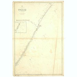
Africa south east coast Sheet VII. Umtavuna River to Tugela River With two coastal profiles Surveyed by Navigating Lieutenant W.e. Archdeacon, R. N. Assisted by Mr. F. Purdy, Civilian, 1872...
A fine Hydrographic Office chart no. 2088 (2198), showing the coast with shepstone, Scottsburg and Durban formerly Port Natal. Engraved by Edw.d Weller. London : Publishe...
Date: London, 1854 / 1900
Selling price: ????
Please login to see price!
Sold in 2019
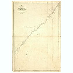
Africa - South East Coast Sheet VI Kaffirland Banshee River to Umtamuuna River Surveyed by Navigating Lieutenant W. E. Archdeacon. R.N. Assisted by Mr F. Purdy, Civilian 1872...
A fine Hydrographic Office chart no. 2087 (2196), showing the coast of Kaffirlandl. Engraved by Edw.d Weller. London : Published at the Admiralty 30th June, 1873, under t...
Date: London, 1872/ 1900
Selling price: ????
Please login to see price!
Sold in 2019
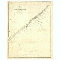
Africa south coast sheet V Cape Colony Waterloo Bay to Bashee River surveyed by Navigating Lieutenant WE Archdeacon RN assisted by ... Africa - SW coast Table Bay surveyed by Mr F Skead Master RN assisted by Mr Charles Watermeyer 1858-60
A fine Hydrographic Office chart no. 2086 (2194), showing the coast from Waterloo Bay to Mbhashe River. Engraved by Edw.d Weller. London : Published at the Admiralty 5th ...
Date: London, 1872/ 1900
Selling price: ????
Please login to see price!
Sold in 2019
Africa east coast River Zambezi to Mozambique Harbour surveys by Captain W. F. W. Owen HMS Leven and Barracouta 1824... With additions and corrections to 1883...
A fine Hydrographic Office chart no. 1810 (2218), showing the coast from Zambesi river to Mozambique Harbour. Engraved by Edw.d Weller. London : Published at the Admiralt...
Date: London, 1883 / 1900
Selling price: ????
Please login to see price!
Sold in 2019
![Africa east coast / Delagoa Bay to river Zambezi surveyed by Captain Pelham Aldrich assisted by [...] HMS Sylvia 1884](/uploads/cache/43757-250x250.jpg)
Africa east coast / Delagoa Bay to river Zambezi surveyed by Captain Pelham Aldrich assisted by [...] HMS Sylvia 1884
A fine Hydrographic Office chart no. 648 (2208), showing the coast from Delagoa Bay (Maputo Bay) to Zambezi. Engraved by Davies & Comp. London : Published at the Admi...
Date: London, 1884 / 1900
Selling price: ????
Please login to see price!
Sold in 2019
Sheet VIII Africa east coast Cape Delgado to Kilwa surveyed by Lieutenant Commanding FJ Gray RN HMS Nassau 1874-5...
A fine Hydrographic Office chart no. 1808 (2224), showing the coast from Cape Delgado to Kilwa. Engraved by Davies & Company. London : Published at the Admiralty 1st ...
Date: London, 1875 / 1900
Selling price: ????
Please login to see price!
Sold in 2019
Sheet VII Africa east coast Ras Pekawi to Cape Delgado including the north part of the Kerimba islands Surveyed by Lieutenant Commanding, F. J. Gray, R. N., ... 1875...
A fine Hydrographic Office chart no. 658 (2223), showing the coast from Ras Pekawi to Cape Delgado. Engraved by Davies & Company. London : Published at the Admiralty ...
Date: London, 1875 / 1900
Selling price: ????
Please login to see price!
Sold in 2019
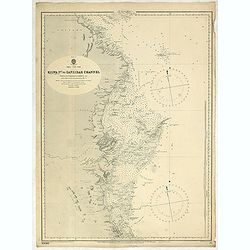
Sheet IX Africa east coast Kilwa P.t to Zanzibar Channel Surveyed by Commander W. J. L. Wharton... , F. J. Gray, R. N., ... 1874-77... Magnetic variation in 1900, decreasing about 2' annually.
A fine Hydrographic Office chart no. 662 (2230), showing the coast from Kilwa P.t to Zanzibar Channel. Engraved by Davies & Company. London : Published at the Admiral...
Date: London, 1875 / 1900
Selling price: ????
Please login to see price!
Sold in 2019
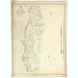
Africa east coast Zanzibar to Malindi ... H. M. Surveying ship Stork, 1888-90. Magnetic variation in 1890, decreasing slightly. Africa - SW coast Table Bay surveyed by Mr F Skead Master RN assisted by Mr Charles Watermeyer 1858-60
A fine Hydrographic Office chart no. 664 (2235), showing the coast from Zanzibar to Malindi with Zanzibar and Pemba Islands. Engraved by Davies & Company. London : Pu...
Date: London, 1890 / 1900
Selling price: ????
Please login to see price!
Sold in 2019
Africa east coast, Port Mombasa with Ports Kilindini, Reitz and Tudor... H. M. Surveying ship Stork, 1888. Africa - SW coast Table Bay surveyed by Mr F Skead Master RN assisted by Mr Charles Watermeyer 1858-60
A fine Hydrographic Office chart no. 666 (2243), showing Mombasa Harbour and Island. Engraved by Davies & Company. London : Published at the Admiralty 30th. May, 1890...
Date: London, 1888 / 1900
Selling price: ????
Please login to see price!
Sold in 2019
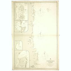
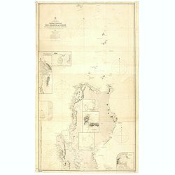
Africa east coast Mozambique Harbour to Ras Pekawi surveys by Captain WFW Owen HMS Leven and Barracouta 1824... Magnetic variation in 1900, decreasing about 2' annually. . .
A fine Hydrographic Office chart no.1809 with six insets : 1. Ibo Harbour surveyed by Captain W.F.W. Owen RN 1824 circa 1:20,000.2. Pomba Bay [Mwabi or Pemba] surveyed by...
Date: London, 1883 / 1900
Selling price: ????
Please login to see price!
Sold in 2019
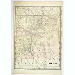
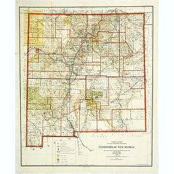
New Mexico.
A large, detailed map of New Mexico, possibly published at the turn of the last century. Each county is color coded, parcels of land and property are recorded, together w...
Date: Unknown, ca 1900
Selling price: ????
Please login to see price!
Sold in 2019
Africa east coast Pangani to Ras Kimbiji including the approaches to Zanzibar... Surveyed by commander W. J. L. Wharton. . .
A fine Hydrographic Office chart no. 640a and 640b of the coast with Dar es Salaam and the Island of Zanzibar. Engraved by Edw.d Weller. London : Published at the Admiral...
Date: London, 1873-74 / 1900
Selling price: ????
Please login to see price!
Sold in 2019
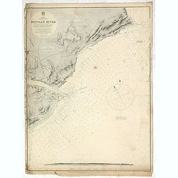
Africa east coast Buffalo River... Surveyed by Nav.g Lieut.t W. E. Archdeacon, R.N., 1868. . .
A fine Hydrographic Office chart no. 1843 (2195) figuring the coast with Dar es Salaam and the Island of Zanzibar. Engraved by Edw.d Weller. London : Published at the Adm...
Date: London, 1893 / 1900
Selling price: ????
Please login to see price!
Sold in 2019
Africa east coast Chale Point to Pangani including the island of Pemba surveyed by Commander WJL Wharton HM surveying ship Fawn . . .
A fine Hydrographic Office chart no. 1390 of Pemba channel with one inset plan. Irregular shape. Inset: Wasin Channel by Commander T F Pullen. Engraved by Davies and Comp...
Date: London, 1899 / 1900
Selling price: ????
Please login to see price!
Sold in 2019
Nieuw Amsterdam op t Eylant Manhattans.
The rare and earliest obtainable view of Manhattan of ca. 1650 by J. Blaeu. The view is based on a prototype drawing, dated by J.M. de Koning to the year 1648, discovered...
Date: Amsterdam, 1652 but likely ca. 1900
Selling price: ????
Please login to see price!
Sold in 2020
Africa east coast Delagoa Bay (Lorenzo Marques) surveyed by Captain WFW Owen and the officers of HMS Leven and Barracouta 1822-5. . .
A fine Hydrographic Office chart no.644 (2205), showing Africa's east coast with Delagoa Bay (Lorenzo Marques) surveyed by Captain WFW Owen and the officers of HMS Leven ...
Date: London, 1885 / 1900
Selling price: ????
Please login to see price!
Sold in 2019
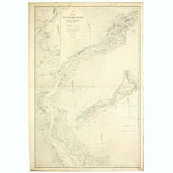
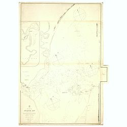
Delaware River from Cohansey to Philadelphia. From the United States Coast Survey, 1882. Inner sheet 2.
A fine Hydrographic Office chart no. 2564 figuring the Delaware River from Cohansey to Philadelphia based on a United States Coast Survey from 1882. Inner sheet 2. Engrav...
Date: London, 1882 / 1900
Selling price: ????
Please login to see price!
Sold in 2019
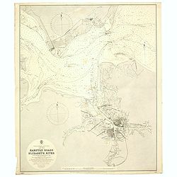
Hampton road and Elizabeth River. . .
A fine Hydrographic Office chart no. 2818, figuring Hampton Road, the James and Elizabeth Rivers and the cities of Norfolk and Portsmouth. Engraved by J. and C. Walker. L...
Date: London, 1892 / 1900
Selling price: ????
Please login to see price!
Sold in 2020
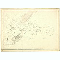
East Coast, Gulf of Mexico, Texas - Galveston Entrance from the latest United States Government Chart.
A fine Hydrographic Office chart no. 192 (1714) showing Galveston entrance. Engraved by Davies & Company. London : Published at the Admiralty, 6th Nov.r 1897 under th...
Date: London, 1897/ 1900
Selling price: ????
Please login to see price!
Sold in 2019
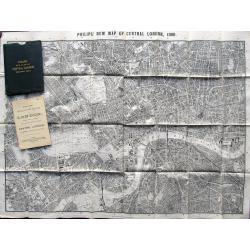
Philips New Map of Central London. 1900
Large plan of London printed on thin cloth! Shows central London in great detail, extending to Kentish Town, London Docks, South Lambeth, Notting Hill. With Philips Minia...
Date: London, 1900
Selling price: ????
Please login to see price!
Sold in 2019

Giuoco Delle Frutta.
Unusual game of the Goose without numbered boxes but showing dices.More about game boards [+]
Date: Italy, ca. 1900
Selling price: ????
Please login to see price!
Sold in 2021
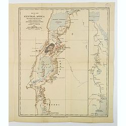
Sketch Map of Central Africa between the Region of Lake Tanganyika and Albert Edward Nyanza.
An attractive folding map titled "Sketch Map of Central Africa between the region of Lake Tanganyika and Albert Edward Nyanza, illustrating the Journey of Ewart S. G...
Date: London, 1900
Selling price: ????
Please login to see price!
Sold in 2019
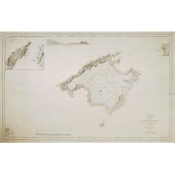
Carta de la isla de Mallorca Levantada en los anos de 1889 a 1893..
Map of the island Mallorca showing also part of Minorca and Ibiza. Inset map of the Canal entre Dragonera y Mallorca, inset profile of the coast. Lighthouses contemporary...
Date: Madrid, Deposito Hidrografico, 1900
Selling price: ????
Please login to see price!
Sold

Carta de las islas de Ibiza y Formentera Levantada en los anos 1895 a 1897..
Map showing the islands Ibiza and Formentora, engraved by L. Galvan. 5 Inset profiles of the coast. Numerous place names, soundings and sand banks are shown round the isl...
Date: Madrid, Deposito Hidrografico, 1900
Selling price: ????
Please login to see price!
Sold
![[ University building Leiden. ]](/uploads/cache/26985-250x250.jpg)
[ University building Leiden. ]
Etching by G.C.Haverkamp (1872-1926) showing the building of Leiden University on the Rapenburg, seen from beyond the canal.Signed with pencil under bottom-right by the a...
Date: Netherlands ca. 1900
Selling price: ????
Please login to see price!
Sold in 2014

Retour de la chasse au cerf.
A nobly dressed couple stand on a path outside their castle, welcoming their males returning from the hunt; landscape background with trees, a river and a distant castle,...
Date: Paris (?), c.1900
Selling price: ????
Please login to see price!
Sold in 2009

Neo-Gothic illuminated manuscript on vellum.
Wide panel border with designs of colored acanthus leaves and fine penwork in black. Including a fine miniature of Mother Maria and Jesus. With a 18 lines verse in Latin....
Date: Belgium, c. 1900
Selling price: ????
Please login to see price!
Sold in 2011
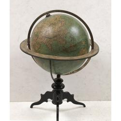
Terrestrial Globe constructed by Th. Mettke.
Height with stand 62cm. Two sets of twelve colored lithographed paper gores, on an ebonized stand. Some very minor brown spotting and place on globe touched up.Terrestria...
Date: Berlin, ca.1890~1900
Selling price: ????
Please login to see price!
Sold
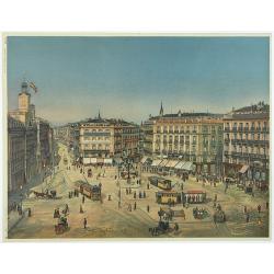
Madrid Puerta Del Sol
The Puerta del Sol (Spanish for "Gate of the Sun") is one of the most well known and busiest places in Madrid. This is the centre of the radial network of Spani...
Date: Germany, c. 1900
Selling price: ????
Please login to see price!
Sold in 2013
![Bassin inférieur du Yang-Tse Kiang. [Nanjing, Hangzhou and Shanghai ]](/uploads/cache/29885-250x250.jpg)
Bassin inférieur du Yang-Tse Kiang. [Nanjing, Hangzhou and Shanghai ]
Very detailed (1:1.000.000) map centered on Nanjing, Hangzhou and Shanghai, showing soundings, English, Australian, Danish telegraph lines reaching Shanghai.The French Se...
Date: Paris, 1900
Selling price: ????
Please login to see price!
Sold in 2011
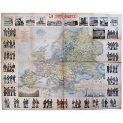
Carte de l'Europe Publieépar Le Petit Journal. . .
A rare map of Europe. An interesting and very detailed map of Europe at ca.1900, designed by A. Guibal, and engraved and printed by Charaire et Cie as a separately publis...
Date: Paris, ca 1900
Selling price: ????
Please login to see price!
Sold in 2020
![Battle of Paardeberg. [Situation about 5pm].](/uploads/cache/45359-250x250.jpg)
Battle of Paardeberg. [Situation about 5pm].
[Map no.8a] The Battle of Paardeberg or Perdeberg ("Horse Mountain") was a major battle during the Second Anglo-Boer War. It was fought near Paardeberg Drift on...
Date: Edinburgh / London, ca 1900
Selling price: ????
Please login to see price!
Sold in 2021
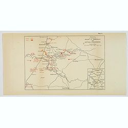
Sketch Map to illustrate the Relief of Kimberley and Battle of Paardeberg.
[Map no.8] The Siege of Kimberley took place during the Second Boer War at Kimberley, Cape Colony (present-day South Africa) when Boer forces from the Orange Free State a...
Date: Edinburgh / London, ca 1900
Selling price: ????
Please login to see price!
Sold in 2021
![Actions at Vaalkranz 5th-7th February 1900 [Situation at Noon 6th February].](/uploads/cache/45362-250x250.jpg)
Actions at Vaalkranz 5th-7th February 1900 [Situation at Noon 6th February].
[Map no.7] The Battle of Vaal Krantz (5 February to 7 February 1900) was the third failed attempt by General Redvers Buller's British army to fight its way past Louis Bot...
Date: Edinburgh / London, 1900
Selling price: ????
Please login to see price!
Sold in 2021
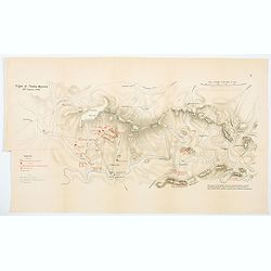
Fight at Thaba Myama 20th January, 1900.
[Plan no.5] A nice and detailed plan of the 'Fight at Thaba Myama', which took place 20th January 1900, between the Republic of South Africa and the Orange Free State and...
Date: Edinburgh, London, ca 1900
Selling price: ????
Please login to see price!
Sold in 2021
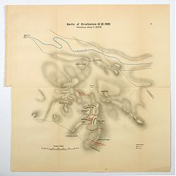
Battle of Driefontein, 10th March, 1900. Situation about 5.30pm.
[Plan no.4] The Battle of Driefontein on the the10th March 1900 followed on the Battle of Poplar Grove in the Second Boer War between the British Empire and the Boer repu...
Date: Edinburgh, London, ca 1900
Selling price: ????
Please login to see price!
Sold in 2021
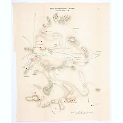
Battle of Poplar-Grove, 7th March, 1900. Situation about 8.00am.
[Plan no.3] Battle of Poplar Grove. was an incident on the 7th March 1900 during the Second Boer War in South Africa. It followed on from the Relief of Kimberley as the B...
Date: Edinburgh, London, ca 1900
Selling price: ????
Please login to see price!
Sold in 2021
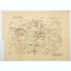
Positions in Natal. Beginning and Middle of January, 1900.
[Plan no.2] A detailed plan of British and opposing Boer Forces as they were in the January of 1900, at the beginning of the second Boer War campaign. It shows the Britis...
Date: Edinburgh, London, ca 1900
Selling price: ????
Please login to see price!
Sold in 2021
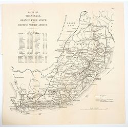
Map of the Transvaal, Orange Free State and British South-Africa.
A large scale, easy to read map of British South Africa (Cape Colony) and the Orange Free State and Transvaal, and north to Rhodesia (Zimbabwe). The map offers an extensi...
Date: Edinburgh, London, ca 1900
Selling price: ????
Please login to see price!
Sold in 2021
![[Sketch 1] View of the Boer position as seen from the naval guns on 14th Dec 1899 / Sketch of the country round Colenso taken on the right bank.](/uploads/cache/45487-250x250.jpg)
[Sketch 1] View of the Boer position as seen from the naval guns on 14th Dec 1899 / Sketch of the country round Colenso taken on the right bank.
[Map no.5] A pair of Boer War sketches. The first shows land sections of Groblers Kloof, Ladysmith, Fort Wylie, Colenso, Hlangwane Hill and the Tugela River, as seen from...
Date: Edinburgh, London, ca 1900
Selling price: ????
Please login to see price!
Sold in 2021
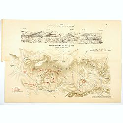
Battle of Spion Kop. 24th January, 1900 Situation soon after 10 a.m.
[Map no.6] The Battle of Spion Kop was fought about 38 km (24 mi) west-south-west of Ladysmith on the hilltop of Spioenkop, along the Tugela River, Natal in South Africa ...
Date: Edinburgh / London, 1900
Selling price: ????
Please login to see price!
Sold in 2021
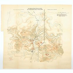
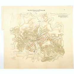
The Fighting at Monte Cristo on the 18th, and at Wynne's Hill on the 22nd February, 1900.
[Map no.8] Map is divided into two, the situation at 6pm on the 22nf Feb (Wynne's Hill) & the situation at *am on the 18th Feb (Monte Cristo). Concerning the fighting...
Date: Edinburgh / London, 1900
Selling price: ????
Please login to see price!
Sold in 2021
Battle of Colenso, 15th December 1899, Situation about 7 a.m.
[Map no.6] The battle of Colenso was the third and final battle fought during the Black Week of the Second Boer War. It was fought between British and Boer forces from th...
Date: Edinburgh, London, ca 1900
Selling price: ????
Please login to see price!
Sold in 2021
Disposition of the British Forces in January 1900.390
[Map no.2] A large folding map showing British forces in South Africa as of January 1900, covering vast distances in the Cape Colony and The Orange Free State. A sketch m...
Date: Edinburgh, London, ca 1900
Selling price: ????
Please login to see price!
Sold in 2021
Fight north of Colenso on the 27th February, 1900. Situation about 5pm.
[Map no.9] On 27th February 1900, the pontoon bridge was moved to a position further east along the river and the British launched an attack across the Tugela on the hill...
Date: Edinburgh, London, ca 1900
Selling price: ????
Please login to see price!
Sold in 2021
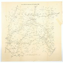
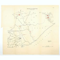
General Map for the Operations till November, 1900
[Map no.1] A large folding map showing the field of all British operations up until November 1900. It stretches from Kimberley (OFS) in the SW to Lyndenburg in the NW (Tr...
Date: Edinburgh, London, ca 1900
Selling price: ????
Please login to see price!
Sold in 2021
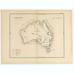
L'Australia. (N°51)
Small map of general Australia.
Date: France, ca. 1900
Selling price: ????
Please login to see price!
Sold in 2020
![[Pictorial world map]](/uploads/cache/46857-250x250.jpg)
[Pictorial world map]
Pictorial wold map showing the different ways of travelling around the world.
Date: Germany, ca. 1900
Selling price: ????
Please login to see price!
Sold in 2020
![[Detailed folding map of Nickerie River, Nickerie, Coronie in Suriname]](/uploads/cache/47218-250x250.jpg)
[Detailed folding map of Nickerie River, Nickerie, Coronie in Suriname]
Detailed folding map of Nickerie River, Nickerie, Coronie in Suriname. The Nickerie is a river in the northwestern part of Suriname. The river originates in the Bakhuis M...
Date: Surinam, or Netherlands, ca. 1900
Selling price: ????
Please login to see price!
Sold in 2022
Théâtre des opérations en Chine : environs de Pékin.
Uncommon map of the surroundings of Beijing and inset plan of Beijing, drawn up by the French Service géographique of the French army in 1900, during the repression of t...
Date: Paris, 1900
Selling price: ????
Please login to see price!
Sold in 2021

Face or Fortune Know Thy Self.
A most unusual item. A volvelle from Woodbury [Facial] Soap Face or Fortune - Know Thy Self with an astrological volvelle & dial on the reverse. Complete with 16 pp s...
Date: New York ca 1900
Selling price: ????
Please login to see price!
Sold in 2022
![[No titles. Two miniature terrestrial globes]](/uploads/cache/48149-250x250.jpg)
[No titles. Two miniature terrestrial globes]
A rather unique pair of small miniature terrestrial globes; one in French, one in English. Both are colored. The globe in French has its own metal stand, and the geograph...
Date: Unknown ca 1900
Selling price: ????
Please login to see price!
Sold in 2022
![[Game of the goose] Het nieuw vermakelijk ganzenspel. Le nouveau jeu d'Oie.](/uploads/cache/48330-250x250.jpg)
[Game of the goose] Het nieuw vermakelijk ganzenspel. Le nouveau jeu d'Oie.
Game of 63 boxes, spiral, counter clockwise. Goose board game with spiral with 63 numbered squares. In different boxes a representation of a goose. In a box on the center...
Date: Turnhout, ca.1900
Selling price: ????
Please login to see price!
Sold in 2023
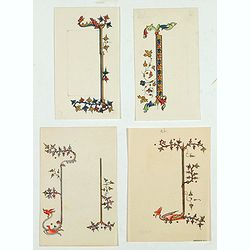
Four illuminated neo-gothic cards on vellum paper for a Book of Hours, in French.
Four very finely executed drawings of border designs on vellum paper, being a model for a neo gothic religious book. Made in the atelier of the Parisian publisher of reli...
Date: Paris, ca. 1900
Selling price: ????
Please login to see price!
Sold in 2023
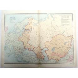
A Sketch of the Acquisition of Russia in Europe and Central Asia Since the Accession of Peter 1st to the Throne.
Large chromo-lithograph map of Russia with portions of surrounding countries featuring the areas of land that Russia acquired from them. Interesting historical facts are ...
Date: London, 1901
Selling price: ????
Please login to see price!
Sold in 2015
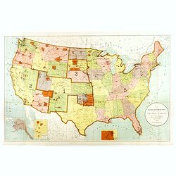
Map Showing Indian Reservations Within The Limits of the United States Compiled Under The Direction of the Hon. T. J. Morgan Commissioner of Indian Affairs 1901.
Fine example of the Indian Affairs Commissioner's Map of the United States. The present map locates all the lands reserved to Native American Tribes as of 1901.Inset maps...
Date: Washington D.C, 1901
Selling price: ????
Please login to see price!
Sold in 2017
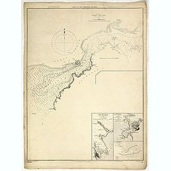
Ports in the Philippine Island. Panay I. Port Ilo Ilo.
A fine Hydrographic Office chart no. 2391 (2649), corrected to Nov.r 1901 from a United States Government Suvey, 1900-1 and published during the Spanish American War.Show...
Date: London, 1864 / Nov.r 1901
Selling price: ????
Please login to see price!
Sold in 2019
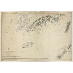
Korea - Korean Archipelago Southern Portion..
Large chart representing the southern part of Korea. A couple of places are highlighted in red and yellow.Relief shown pictorially.
Date: London, 1901
Selling price: ????
Please login to see price!
Sold in 2019
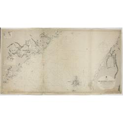
China East Coast - The Brothers to Ockseu I s Including the West Coast of Formosa..
Large chart representing the eastern coast of China to the right the West coast of Taiwan. Some places are highlighted in red and yellow.With two inset plans containing t...
Date: London, 1891 with updates to 1901
Selling price: ????
Please login to see price!
Sold in 2020

Livre d'heures offert par les augustines de Vitré France.
Book of hours made in the monastery of Vitré in France (Bretagne), which monastery closed in 1975. Each of the 102 pages is decorated with a different border. Each page ...
Date: Vitré, 1901
Selling price: ????
Please login to see price!
Sold in 2021
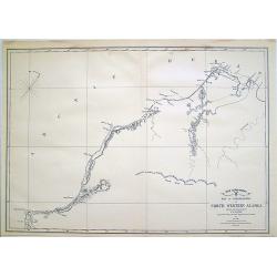
War Department Map of Exploration of North Western Alaska...
Unusual survey map of the Arctic Ocean and Northwestern Alaska.
Date: 1902
Selling price: ????
Please login to see price!
Sold in 2010
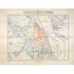
Plan de la ville de Hanoi.
Rare and detailed plan of Hanoi, scale 1:10.000. The plan was published at the occasion The Exhibition of Hanoi which opening its doors on November 3, 1902. The exhibitio...
Date: Hanoi, November 1902
Selling price: ????
Please login to see price!
Sold in 2013
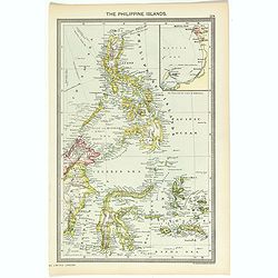
The Philippine Islands.
Map of Philippine Islands with inset map of Manila Habor.
Date: London, ca. 1902
Selling price: ????
Please login to see price!
Sold in 2018
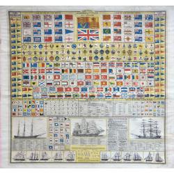
Brown's Standards and Flags of all Nations.
Lithograph by James Brown of Glasgow. Standards and Flags of all Nations with flags of the British Empire, colonial badges, flags of the Royal Yacht Clubs and pendants, w...
Date: Glasgow, 1902
Selling price: ????
Please login to see price!
Sold in 2019
Sabine Pass and Lake / Louisiana and Texas (Polyconic proJection) / Scale 1/40 000.
A fine Hydrographic Office chart no. 517 showing Sabine Pass and Lake with Port Arthur in Louisiana and Texas.Published at Washington D.C. April, 1901, by the U. S. Coast...
Date: Washington D.C, 1901-1902
Selling price: ????
Please login to see price!
Sold in 2019
De L'Ile Namoa Aux Iles Ockseu..
Large chart centred on the Taiwan Strait, showing the southern coast of China and part of the western coast of Taiwan. Some places are highlighted in red and yellow.Conta...
Date: Paris, 1897, updates to 1902
Selling price: ????
Please login to see price!
Sold in 2020
Department of the interior . . . Territory of New Mexico Compiled from the official Records. . .
Photolithography by Andrew B. Graham Washington, DC. Revised and drawn by Charles J. Helm.Detailed sepia tone topographic plat map with Indian Reservations in yellow, for...
Date: Washington, 1903
Selling price: ????
Please login to see price!
Sold in 2014
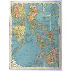
Philippine Islands.
Fine chromolithograph or colored lithograph map Of the Philippines, with insets of Manila, Manila to Dagupan, China Sea, Sulu Archipeligop and Batanes (Bashee). From �...
Date: Chicago, 1903
Selling price: ????
Please login to see price!
Sold in 2016
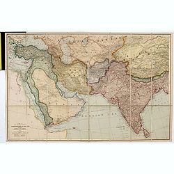
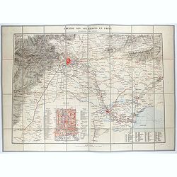
A map of the countries between Constantinople and calcutta including Turkey in Asia, Persia, Afghanistan & Turkestan.
Scarce example of Edward Stanford’s map folding map of Arabia, reaching up to India. Still in its original publisher's yellow advertisements at end papers, folding into...
Date: London, 1903
Selling price: ????
Please login to see price!
Sold in 2017
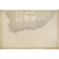
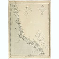
South Africa - Cape of Good Hope and adjacent coasts from Hondeklip Bay to Port Natal. Chart 2176.
Large chart representing the Cape of Good Hope and the surrounding area. A couple of places on the coastline are highlighted in red and yellow.Title flanked by explicativ...
Date: London, 1867 updated for 1903
Selling price: ????
Please login to see price!
Sold in 2018
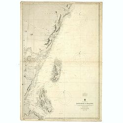
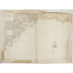
Northern Portion of The Island of Luzon with the Bashi & Balintang Channels The Island of Luzon by Lieutenant Claudio Montero Royal Spanish Navy 1859 The Batan Islands by Captain Sir. E. Belcher R.N. 1845.
Detailed chart on two joined sheets showing the northern portion of the Island of Luzon with the Bashi and Balintang Channels, drawn by Lieutenant Claudio Montero of the ...
Date: London, 1867 / c. 1903
Selling price: ????
Please login to see price!
Sold in 2019