Browse Listings
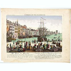
L'interieur du port de marseille...
A so-called optical print. A lively and harbor scene of Marseille, with many people loading a vessel. Engraved by Balthazar Frederic Leizelt.. The image is actually of a...
Date: Augsburg, c. 1750
Selling price: ????
Please login to see price!
Sold in 2016
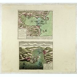
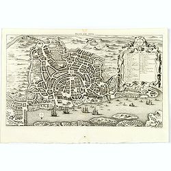
Portus Pulchri in Isthmo Panamensi / Scenographia Portus Pulchri
The birds-eye town-plan of Portobelo with title above, and a text panel "Dieser Grund Riss von dem Hafen, der Stadt u. den Forten von Porto belo ..." Below a sc...
Date: Nuremberg, c. 1750
Selling price: ????
Please login to see price!
Sold in 2015
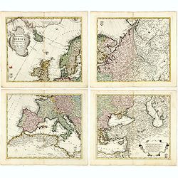
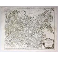
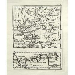
Tabula Geographica Europae. . .
Interesting map in four sheets, forming a map of Europe, including good detail on Scandinavia, Russia, Poland with a decorative title cartouche, and a Prussian duty stamp...
Date: Berlin, ca. 1750
Selling price: ????
Please login to see price!
Sold in 2017

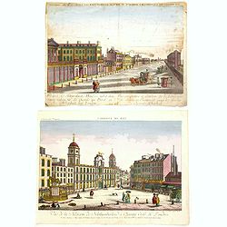
Vue generale de la ville de Londres
A 'bird's-eye' view of London, taken from a point several hundred feet above Tower Bridge. Note: St. Paul's church, the Monument to the fire of London, and Westminster Ab...
Date: Paris, ca 1750
Selling price: ????
Please login to see price!
Sold in 2016
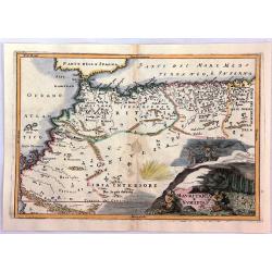
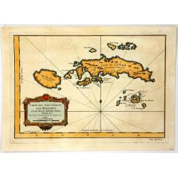
Mauritania E Numidia.
A striking map of the Barbary Coast, or northern Africa in antiquity. The map depicts the ancient empires of Mauritania and Numidia currently known as Morocco and Algeria...
Date: Paris, ca. 1750
Selling price: ????
Please login to see price!
Sold in 2016
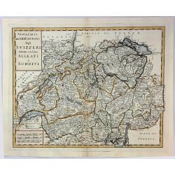
Nuova Carta dei XIII Cantoni degli Svizzeri infieme coi loro Alleati e Sudditi.
Taken from Volume II of Albrizzi's "Atlante Novissimo" after Guillaume de L'Isle. Showing Switzerland divided into its various cantons, with major towns, cities...
Date: Padua, 1750
Selling price: ????
Please login to see price!
Sold in 2016
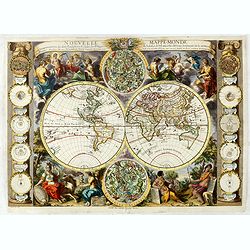
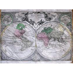
Nouvelle mappe-monde avec la représentation des deux hémisphères ... Gravée par Delamonce et publiée par Daudet, marchand de cartes à Lyon. . .
First state: This state does not include a Mer de L'Ouest as in state 2. Lower left, "Delamonce Inv. Et del. Avec Privilege du Roy". Lower center, "A LYON ...
Date: Lyon, 1750
Selling price: ????
Please login to see price!
Sold in 2016
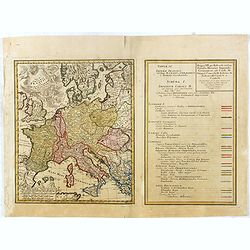
Tab. IV Imperii Francici vel Romano German f. Romani Occid . . .
Uncommon map and table depicting the divisions of Europe, during the reign of the Holy Roman Emperor Charles V.
Date: Nuremberg / 1750
Selling price: ????
Please login to see price!
Sold in 2017
![Mappa Geographica Complectens I. Indiae Occidentalis Partem Mediam Circum Isthmum Panamensem. . . [With insets of St. Augstine, Florida, Mexico City, Panama, etc.]](/uploads/cache/37359-250x250.jpg)
Mappa Geographica Complectens I. Indiae Occidentalis Partem Mediam Circum Isthmum Panamensem. . . [With insets of St. Augstine, Florida, Mexico City, Panama, etc.]
Six varying sized insets depict the West Indies: Panama, Saint Augustine, Vera Cruz, Santo Domingo, and a birds-eye view of Mexico City. The primary, largest inset map ha...
Date: Nuremberg, 1750
Selling price: ????
Please login to see price!
Sold in 2016
Two Optical prints of London
Two optical prints "Prospect des Admiralitaets Hauses, nebst dem neuen Gebäu für die Quarde zu Pferd" and "Vue de la Maison de Northumberland à Charing ...
Date: Augsburg 1750
Selling price: ????
Please login to see price!
Sold in 2016
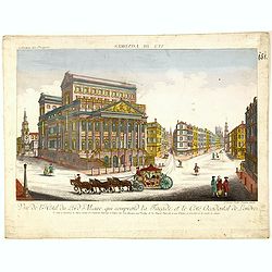
Vue de l Hotel du Lord Maire, qui comprend la Façade, et le Cot' Occidental de Londres.
Shows the famous Lord Mayor's coach driving through London. The Lord Mayor's coach is famous for its role in the Lord Mayor's Show, which is one of the longest establishe...
Date: Augsburg, 1750
Selling price: ????
Please login to see price!
Sold in 2016
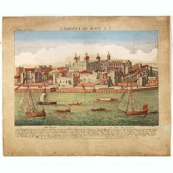
Der Tower La Tour de Londres.
Optical view by J.B. WINCKLER after L. KNYF, German and French captions below, In the eighteenth and nineteenth centuries there were many popular speciality establishment...
Date: Augsburg, 1750
Selling price: ????
Please login to see price!
Sold in 2016

Three Optical prints of London. . .
Three optical prints of London "An Inside View of the Rotundo in London Caff. - Vue interieur de la Rotonde oú le Caffé", with "A View of the Royal Palac...
Date: London, ca. 1750
Selling price: ????
Please login to see price!
Sold in 2016
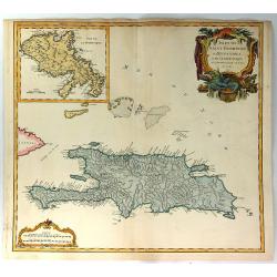
Isles de Saint Domingue ou Hispaniola, et de la Martinique.
This is a fine map of Hispaniola or Santo Domingo (modern day Haiti and the Dominican Republic) by Robert de Vaugondy. It includes the tip of Cuba and the Inagua Islands ...
Date: Paris, 1750
Selling price: ????
Please login to see price!
Sold in 2020
Nova et Accuratissima Maris Caspii....
Highly decorative map showing the Caspian Sea and the countries around it. Main cities / countries around it include: Baky / Baku in Aserbaidschan, Astrakhan / Astrakha...
Date: Augsberg, 1750
Selling price: ????
Please login to see price!
Sold in 2016
Newport a Strong Sea-Port Town in Flanders, Restored to the Empire by the Treaty of Utrecht.
A hand colored plan of Newport, a sea port town of Flanders from Tindal's Continuation of Mr. Rapin's "HISTORY OF ENGLAND". Engraved by James Basire in London c...
Date: London, ca. 1750
Selling price: ????
Please login to see price!
Sold in 2016
A General Map of the River Sanaga or Senegal
A map of the River Sanaga or Senegal on the west coast of Africa, from the falls of Govina to the Ocean. Main map has two insets: 1. Location of Fort St Joseph; Plan of F...
Date: Paris, 1750
Selling price: ????
Please login to see price!
Sold in 2016

Carte de la Baye de Chin-Chew ou Chang-Chew avec les Isles d'Emowi et de Quimowi
A copper engraved chart of the estuary of the Chiu-lung River at present-day Hsia-men, on the mainland coast, adjacent to Taiwan. Chart shows the location of a few villag...
Date: Paris, c1750
Selling price: ????
Please login to see price!
Sold in 2016
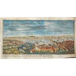
Londra, capitale dell'Inghilterra
A nice copper engraving depicting the city of London, from "Lo stato presente di tutti i paesi e popoli del mondo naturale, politico, e morale", printed in 1750...
Date: Venice, ca 1750
Selling price: ????
Please login to see price!
Sold in 2016

'T Oost Indisch Huys.
A decorative print of the East Indian House , the headquarters of the VOC, a place for meeting, trading and storage of spices and ship equipment.The maps and charts were ...
Date: Amsterdam, 1750
Selling price: ????
Please login to see price!
Sold in 2018
Het Westindisch Eiland Martenique
Taken from Isaac Tirion's atlas 'Nieuwe en Beknopte Hand-Atlas, bestaande in eene Verzameling van eenige der algemeenste en nodigste Landkaarten …' Decorative tropical ...
Date: Amsterdam, 1750
Selling price: ????
Please login to see price!
Sold in 2016
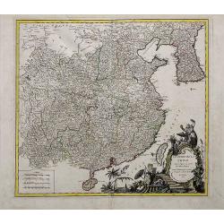
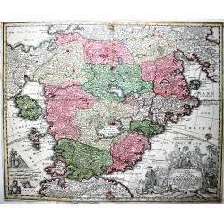
L'Empire de la Chine dressé d'après les cartes de l'Atlas Chinois...
A detailed, large map of China, Korea and Taiwan. The large and spectacular title cartouche is in the typical French style, with musicians, a dancer, and various details ...
Date: Paris, ca 1750
Selling price: ????
Please login to see price!
Sold in 2016
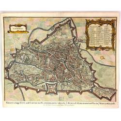
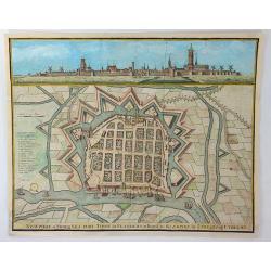
Ghent, a Large City and Castle in Flanders
A very fine bird's-eye plan of the city and fortifications of Ghent and the surrounding countryside in Belgium. A decorative cartouche encloses a detailed key to the map ...
Date: London, 1750
Selling price: ????
Please login to see price!
Sold in 2016
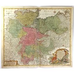
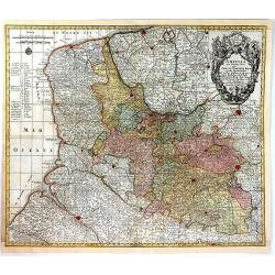
Saxoniae Inferioris circulus, exhibens ducatus Brunswic
This large detailed map of Saxony shows northern Germany with Sachsen Anhalt, Niedersachsen, Mecklenburg Vorpommern, Schleswig, Holstein, Brandenburg, Hamburg, Bremen and...
Date: Augberg, 1750
Selling price: ????
Please login to see price!
Sold in 2016
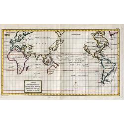
Carte dans laquelle on voit la route que le Centurion a tenu dans le voiage au tour du monde.
A copper engraved map; overall size 33.5 x 50 cmA nicely colored World map, on Mercator's Projection, depicting Anson's voyage around the World. Engraved by Lattre; Frenc...
Date: Paris, ca.1750
Selling price: ????
Please login to see price!
Sold in 2017

Carte du Kamtchatka
One of the best maps of the region from the 1700's. Handsome copper engraved map of the Kamtchatka peninsula with excellent detail showing topography, including several l...
Date: Paris, 1750
Selling price: ????
Please login to see price!
Sold in 2016
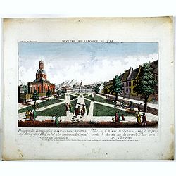
Prospect des Rathhauses in Batavia wie dasselbige auf dem grossen Platz nebst der um liegende Gegend (von fornen anzusehen).
A view of present-day Fatahillah Square in Jakarta. In the middle of the print the Raadhuis , headquarters of the VOC -nowadays the Jakarta museum-is clearly visible.
Date: Augsburg, 1750
Selling price: ????
Please login to see price!
Sold in 2016
Carte des Isles Voisines Des Moluques
An old antique cartographic map of the Molucas Isles in Indonesia, including Ceram - Bouro Amboine - Banda – Neyra, by Bellin from Abbe A.F. Prévost’s, “Histoire G...
Date: Paris, 1750
Selling price: ????
Please login to see price!
Sold in 2016
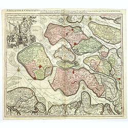
Zeelandiae Comitatus. . .
A scarce map of Zeeland, a section of south-western The Netherlands, published by Matthäus Seutter.Impressive cartouche with coat of arms of Zeeland top left, reflecting...
Date: Augsburg, ca.1750
Selling price: ????
Please login to see price!
Sold in 2017
Artsia cum Finitimis Locis Seden ac Thatrum Belli ...
A fine large map of the Pas-de-Calais / Artois region in northern France, and part of Belgium between Calais, Abeville and Douay, with decorative figural cartouche. By Co...
Date: Nüremburg, 1750
Selling price: ????
Please login to see price!
Sold in 2016
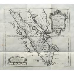
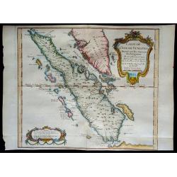
Carte de L'Isle de Sumatra...
A detailed map of Sumatra and parts of the Malay Peninsula with the Straits of Singapore. Many towns, islands, and rivers are named.Decorated with a large title cartouche...
Date: Paris, ca 1750
Selling price: ????
Please login to see price!
Sold in 2017
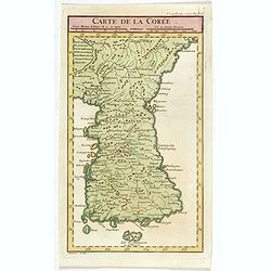
Carte de la Corée.
A rare map of Korea after d'Anville and engraved by Dheulan.
Date: Paris, ca. 1750
Selling price: ????
Please login to see price!
Sold in 2021
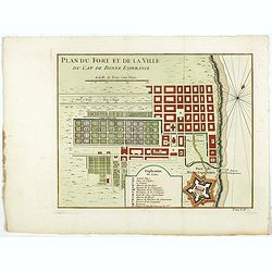
Plan du Fort et de la ville du Cap de Bonne Esperance.
Early plan of the city, the fort and Good Hope Cape. Across the top is an extensive list of 22 important sites and locations keyed to the plan with tiny letters and numbe...
Date: Paris, 1750
Selling price: ????
Please login to see price!
Sold in 2017
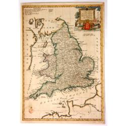
A New and Accurate Map of England.
Fine, very detailed map of England and Wales by Thomas Bowen in about 1750. It has a decorative cartouche with a cannon, a lion, a bust, a globe, and a three-lioned shiel...
Date: London, ca. 1750
Selling price: ????
Please login to see price!
Sold in 2017
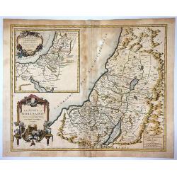
La Judee ou Terre Sainte Divisee en ses Douze Tribus.
Beautiful 1750 map of Israel, Palestine or the Holy Land by Robert de Vaugondy. It extends from Sidon to Gaza and Covers the region as it existed in Biblical times with d...
Date: Paris , 1750
Selling price: ????
Please login to see price!
Sold in 2017
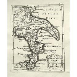
Gross Griechenland oder Apulien, Lucanien und Bruttium.
A rare map of soutern Italy. Shows the area from Apulia to Messina in Sicily, including Salerno, Paestum, Potenza, Bari, Tarent, Lamezia, Crotone, Reggio, and many more w...
Date: Anon, ca. 1750
Selling price: ????
Please login to see price!
Sold in 2018
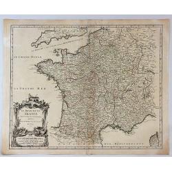
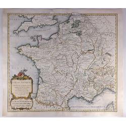
Le Royaume de France Divise Suivant les Gouvernemens Generaux.
A fine politically and topographically detailed 1750 map of France by Robert de Vaugondy. It covers all of France from the English Channel to Corsica and Spain.The map fe...
Date: Paris, 1750
Selling price: ????
Please login to see price!
Sold in 2017
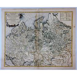
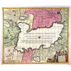
Partie Occidentale de L'Empire de Russie.
A highly detailed map of the Western Part of Russia, extending South to the Caspian and East to Irkurkoy and Ilimskoy. Interesting natural cartouche featuring two bears e...
Date: Paris, 1750
Selling price: ????
Please login to see price!
Sold in 2018
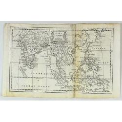
East Indies.
A fine map of the East Indies, bounded by China in the northeast, the Timors and New Guinea in the Southeast, India and the Maldives in the Southwest and Tibet and the Mo...
Date: London, ca. 1750
Selling price: ????
Please login to see price!
Sold in 2017
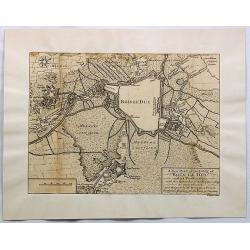
A New Plan of the Town of Bois le Duc and Its Fortifications.
Striking engraved plan showing the city of s'Hertogenbosch in Brabant, Netherlands. The map focuses on the town fortifications and also includes details of the town plan...
Date: London, J. Nourse, 1750
Selling price: ????
Please login to see price!
Sold in 2018
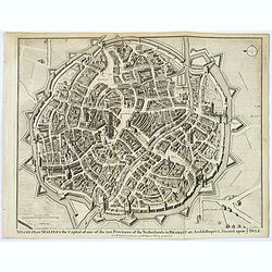
Mechlin, or Malines the Capital of one of the ten Provinces of the Netherlands. . .
A detailed 'bird's eye view of the Belgian city of Mechelen. Streets are named, and houses and buildings are shown in great detail. Prominent buildings shown. City walls ...
Date: London, ca 1750
Selling price: ????
Please login to see price!
Sold in 2020
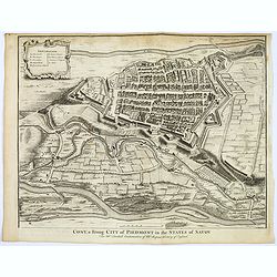
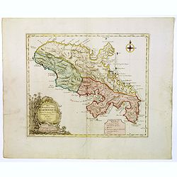
Cony, a strong City of Piedmont in the States of Savoy.
A detailed 'bird's eye view of the Italian city of Cony (Cuneo) and surrounding fields, farmland rivers and terrain.Houses and public buildings are shown in great detail,...
Date: London, ca 1750
Selling price: ????
Please login to see price!
Sold in 2017
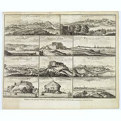
Views of the principal Towns and Castles in Scotland..
A delightful selection of 10 Scottish Towns, Castles, and of The Bass Rock. Towns include Edinburgh, Glasgow, Sterling, Aberdeen, St. Andrews, Montrose, Cannery Town in R...
Date: London, ca. 1750
Selling price: ????
Please login to see price!
Sold in 2021
Partie Orientale de L'Empire de Russie en Asie...
An attractive and detailed map of the northeastern portion of Asia, including Russia, China, the Gobi Desert, etc. Included are cities, villages, rivers, mountain ranges ...
Date: Paris, 1750
Selling price: ????
Please login to see price!
Sold in 2017
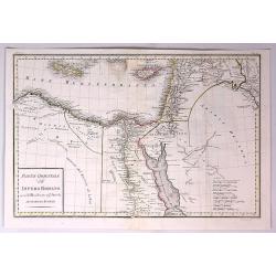
Parte Orientale dell Impero Romano Ossia del Mondo Noto Agl'Antichi.
The eastern part of the Ancient Roman Empire by Anville. It covers the areas of Libya, Egypt and Arabia. Engraved by G. Canrani.Jean Baptiste Bourguignon d'Anville (1697...
Date: Paris, ca. 1750
Selling price: ????
Please login to see price!
Sold in 2017
Plan de Goa.
A beautifully detailed and engraved town-plan of the Portuguese colony of Goa in India, with a number key (1-29) to the city's major monuments and sites, enclosed in a de...
Date: Paris, 1750
Selling price: ????
Please login to see price!
Sold in 2017
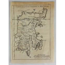
Carte de L'Isle Celebes ou Macassar.
A fine copper engraved map of Celebes Island. It is the provincial capital of South Sulawesi, Indonesia. It is the largest city on Sulawesi Island in terms of population ...
Date: Paris, 1750
Selling price: ????
Please login to see price!
Sold in 2018
Gallia Antiqua in Provincias et Populos Divisa.
An attractive map of France or 'Gaul'. It features Gallia during ancient Roman times, and extends from the English Channel south as far as the Pyrenees Mountains and Hisp...
Date: Paris, 1750
Selling price: ????
Please login to see price!
Sold in 2023
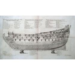
The representation of a first rate shipp in the manner they are usually moddeled.
Large and unusual print of a war ship in great detail. The title and 28 point legend is given in four languages. We could not trace this engraving or find out when and wh...
Date: Berlin, ca. 1750
Selling price: ????
Please login to see price!
Sold in 2018
Carte du Pays ou Probablement a Ete le Paradis Terrestre, la Plaine de Scinhar et la Montagne sur Laquelle L'Arche...
A pleasant map detailing the region of present day Iraq and Armenia. It locates the Garden of Eden on the Euphrates River, by Bellin in Paris, published in 1750.Jacques N...
Date: Paris, 1750
Selling price: ????
Please login to see price!
Sold in 2018
Mappa Totius Mundi Adornata juxta Observationes Dnn Academiae Regalis Scientarum. . .
A very decorative, large double hemisphere map of the World, published by Lotter in Augsburg, before 1775 (no date added in this version).This map is particularly interes...
Date: Augsburg, ca. 1750
Selling price: ????
Please login to see price!
Sold in 2019
![[Two maps] Tetrachia Ducatus Geldriae Neomagensis. / Transisalania vulgo Over-Yssel auct. N. ten Have. . .](/uploads/cache/40600-250x250.jpg)
[Two maps] Tetrachia Ducatus Geldriae Neomagensis. / Transisalania vulgo Over-Yssel auct. N. ten Have. . .
[Two maps] Frederick de Wit's very attractive map of the area of Nijmegen in The Netherlands. North is orientated to the upper right. The map is adorned with a banner sty...
Date: Amsterdam, ca. 1680 - 1750
Selling price: ????
Please login to see price!
Sold in 2018
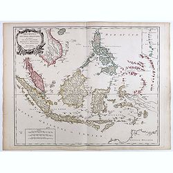
Archipel Des Indes Orientales, qui comprend Les Isles De La Sonde.. Philippines..
An attractive and detailed view of the Indonesian islands in large format and Malacca and Southern China to the Philippines, New Guinea and Northern Australia. Includes a...
Date: Paris, 1750
Selling price: ????
Please login to see price!
Sold in 2018
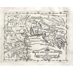
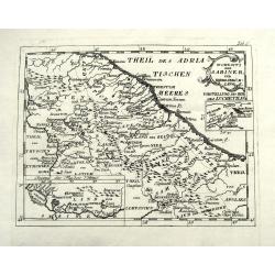
Der Adriatische Meerbusen und die daran graenzende Alte Völker.
A rare map of northern Italy. Shows the area from Brixen to Istria, including Verona, Venice, Trieste, and Pula, by an unidentified and unknown cartographer.
Date: Anon, ca. 1750
Selling price: ????
Please login to see price!
Sold in 2018
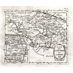
Land der Etrurier und Umbrier.
A rare map of central Italy. Shows the area from Porto Venere until Ancona, including Rome, Pisa, and Siena. An inset map shows the area around Rome. By an unidentified a...
Date: Anon, ca. 1750
Selling price: ????
Please login to see price!
Sold in 2018
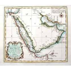
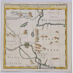
Carte de la coste d'Arabie Mer Rouge et Golfe de Perse. . .
A fine map of the Arabian Peninsula with the Persian Gulf, and the Red Sea. With many place names along the coasts. Decorated with the large title cartouche and some attr...
Date: Paris, ca. 1750
Selling price: ????
Please login to see price!
Sold in 2018
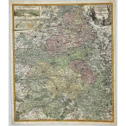
Tabula Geographica Campaniae in Suas Sic Dictas. . .
A map of Champagne, the famous wine provence in France. On the top left are insert views of Reims and Troyes, and a decorative cartouche featuring a king and his subjects...
Date: Nuremberg, ca. 1750
Selling price: ????
Please login to see price!
Sold in 2018
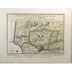
Plan du Fort Anglois et de la Ville du Cap de Corse.
Cap de Corse or Cape Coast Castle on the Gold Coast in Ghana in Africa was called the "Gate of No Return". Originally a 17th century Swedish trading post, it ul...
Date: Paris, 1750
Selling price: ????
Please login to see price!
Sold in 2018
Wohnsitz der Sabiner, und ihrer Abkömlinge.
A rare map of central Italy. Shows the area from Ancona to Benevento, including Rome, Narni, Terni, Ortona, and many more with their old names. An inset map shows the Vel...
Date: Anon, ca. 1750
Selling price: ????
Please login to see price!
Sold in 2018
Vorstellung v. Campanien u. Samnium.
A rare map of the area around Naples. Shows the area from Città di Castello until Salerno. Includes Naples, Nola, Sorrento, islands of Capri and Ischia, and many more wi...
Date: Anon, ca. 1750
Selling price: ????
Please login to see price!
Sold in 2018
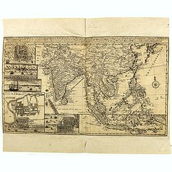
Charte von Ost-Indien und den Angraentzenden Laendern'... 'Geographi Mr. Herman Moll ... Durch M. Georg. Christian Bohnstedt Rector an der Dom-Schule zu Halberst. . .1737
Rare German map showing the area from India to Japan, and south to include the East Indies. The map is filled with information on political divisions, towns, and roads. T...
Date: Lepzig, ca. 1750
Selling price: ????
Please login to see price!
Sold in 2020
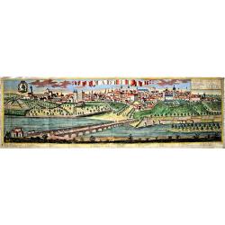
Madrit.
Very rare view of Madrid from Johann Friedrich Probst. Printed on two sheets. Different versions of this exceptional, large view of Madrid were produced by the Probst. No...
Date: Augsburg, ca 1750
Selling price: ????
Please login to see price!
Sold in 2021
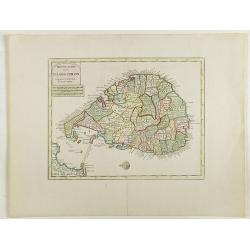
Nieuwe kaart van 't eiland Ceilon.
Fine map of present-day Sri Lanka with north oriented to the left. The legendary Adams Brug (Adam's Bridge or Rama's Bridge) is clearly shown linking Mannar island off Sr...
Date: Amsterdam, 1750
Selling price: ????
Please login to see price!
Sold in 2020
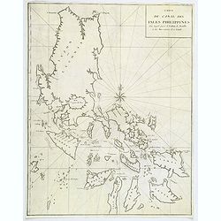
Carte du Canal des Philippines. . .
Large detailed chart of the Islands of the Philippines from the French edition of Anson's Voyages. Anson's voyages were one of the last great buccaneering voyages, and it...
Date: Paris, ca 1750
Selling price: ????
Please login to see price!
Sold in 2018
Plan de Goa.
A beautifully detailed and engraved town-plan of the Portuguese colony of Goa in India, with a number key (1-29) to the city's major monuments and sites, enclosed in a de...
Date: Paris, 1750
Selling price: ????
Please login to see price!
Sold in 2020

Quos ego. Sed motos praestat componere fluctus : Eneid. Virg. Lib.I.
Le Neptune Oriental by D'Après de Mannevillette, a French sailor and hydrographer. Engraved by J.B. Tilliard after F. Boucher. A scene from the first book of Virgil's Ae...
Date: Paris, 1750
Selling price: ????
Please login to see price!
Sold in 2020
ACCURATA UTOPIAE TABULA. . .
A scarce, large map of Utopia land on the model that Pieter Schenk originally published in his Atlas contractus in ca 1700. Schlaraffenland is the imaginary land of idlen...
Date: Not known, ca 1750
Selling price: ????
Please login to see price!
Sold in 2019
Carte de l'Isle de Sumatra....
Map of Sumatra, also showing the tip of the Malay Peninsula and the Straits of Singapore. An unusually detailed map of the area, showing many coastal features, shoals, ba...
Date: Paris, 1750
Selling price: ????
Please login to see price!
Sold in 2018
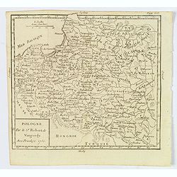
Pologne.
A compact small map of Poland, including Lithuania and Belarus, as they appeared in 1750. Dense detail provided, with topography, place names, rivers and lakes. A nice sm...
Date: Paris, 1750
Selling price: ????
Please login to see price!
Sold in 2019
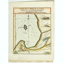
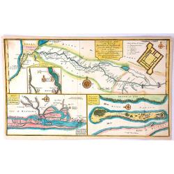
Carte de la Baye de la Table . . .
Map of La Table Bay. Across the top is an extensive list of 22 important sites and locations keyed to the plan with tiny letters and numbers.Jacques Nicolas Bellin (1703-...
Date: Paris, 1750
Selling price: ????
Please login to see price!
Sold in 2021
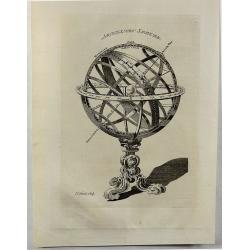
Armillary Sphere.
A fine antique, copperplate print of a celestial armillary sphere, engraved by Thomas Kitchin in 1750. Thomas Kitchin (1718–1784) was an English engraver and cartogra...
Date: London, 1750
Selling price: ????
Please login to see price!
Sold in 2018
![Mappa Geographica Complectens I. Indiae Occidentalis Partem Mediam Circum Isthmum Panamensem. . . [With insets of St. Augstine, Florida, Mexico City, Panama, etc.]](/uploads/cache/42979-250x250.jpg)
Mappa Geographica Complectens I. Indiae Occidentalis Partem Mediam Circum Isthmum Panamensem. . . [With insets of St. Augstine, Florida, Mexico City, Panama, etc.]
Six varying sized insets depict the West Indies: Panama, Saint Augustine, Vera Cruz, Santo Domingo, and a birds-eye view of Mexico City. The primary, largest inset map ha...
Date: Nuremberg, 1750
Selling price: ????
Please login to see price!
Sold in 2019
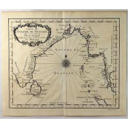
Carte du Golphe de Bengale.
A fine copper engraved map of the Gulf of Bengal including the island of Celon. It features a decorative title cartouche and a large fancy compass rose. Bellin prepared t...
Date: Paris, 1750
Selling price: ????
Please login to see price!
Sold in 2021
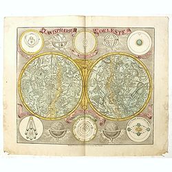
Planisphaerum coeleste.
A very decorative double hemisphere celestial chart. The smaller circular diagram showing the rotation of the Planets, according to Tycho Brahe, Ptolemy and Copernicus. F...
Date: Nurenberg, 1750
Selling price: ????
Please login to see price!
Sold in 2019
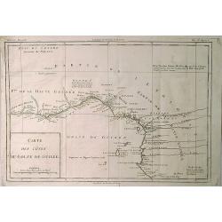
Carte des Cotes du Golfe de Guinee.
A detailed map of the Gulf (Bight) of Benin and part of the Guinea coast The map features many place names, including the Slave Coast.Jacques Nicolas Bellin (1703–1772)...
Date: Paris, 1750
Selling price: ????
Please login to see price!
Sold in 2019
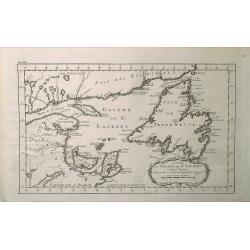
Carte du Golphe de St. Laurent et Pays Voisins.
A map from Prevost's 'Hist. des Voyages', depicting St. Lawrence Bay with Anticosti Island, Prince Edward island, Cape Breton Island, Newfoundland and the adjacent mainla...
Date: Paris, 1750
Selling price: ????
Please login to see price!
Sold in 2020
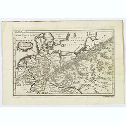
Antient Germany.
A map of Germany in Roman times, that also shows Denmark and southern tip of Sweden, and parts of eastern Europe. With good map detail, including rivers, regions, towns, ...
Date: London, ca 1750
Selling price: ????
Please login to see price!
Sold in 2019
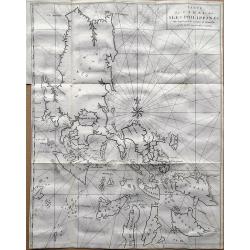
Carte du Canal des Iles Philippines par lequel Passe le Galion de Manille. . .
A detailed copper-engraved sea-chart, the first obtainable large format map, and one of the best maps of the Philippines from the 18th century.It provides excellent detai...
Date: Paris, 1750
Selling price: ????
Please login to see price!
Sold in 2019
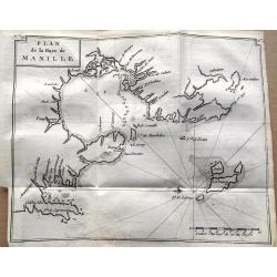
Plan de la Baye de Manille.
One of the earliest obtainable plans of Manila published in 1750. The detailed chart of the Manila Bay includes anchorages, soundings, rocks, and several places are named...
Date: Paris, 1750
Selling price: ????
Please login to see price!
Sold in 2019
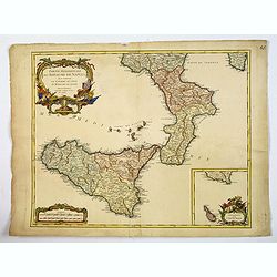
Partie Meridionale du Royaume de Naples. . .
A quite striking map of Sicily, Naples and neighbouring islands, with a large attractive inset of Malta, and extreme southern portion of Sicily, taken from an early editi...
Date: Paris, ca 1750
Selling price: ????
Please login to see price!
Sold in 2019