Browse Listings
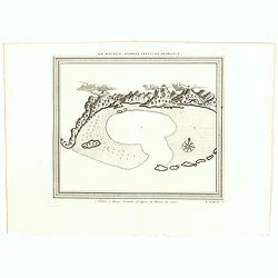
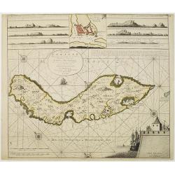
Ile Maurice Nommee Depuis Ile De France.
A fine bird's-eye view and view of the harbor of the Ile Maurice, or Mauritius, from Prevost's "Histoire Des Voyages", 1750.The mountains are covered with cloud...
Date: Paris, 1750
Selling price: ????
Please login to see price!
Sold in 2021
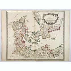
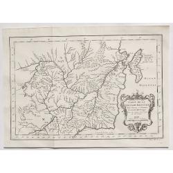
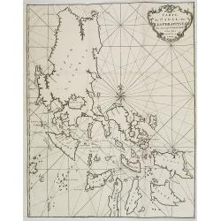
Royaume de Danemark. . .
A nice, detailed map of Denmark, including the Baltic Sea and the lower part of Sweden. Showing towns, rivers, mountains, ports, islands, etc. Adorned with a large title ...
Date: Paris, ca 1750
Selling price: ????
Please login to see price!
Sold in 2020
L'EMPIRE DU JAPON
Large map of Japan with a distinctively French style title cartouche containing two small landscapes.The map draws heavily on the previous work of Bellin, but includes a ...
Date: Paris 1750
Selling price: ????
Please login to see price!
Sold in 2019
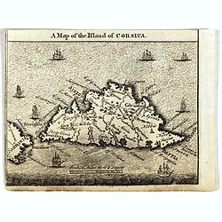
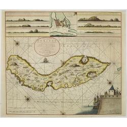
A Map of the Island of Corsica.
Scarce small map of Corsica and part of Sardinia.
Date: England, ca. 1750
Selling price: ????
Please login to see price!
Sold in 2019
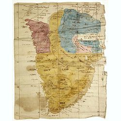
(Cape of Good Hope manuscript map)
Dutch manuscript map of South Africa, with text in Dutch. Showing mountains, rivers, town names and Kingdoms. Fine manuscript map of Southern Africa full of information, ...
Date: Netherlands, ca. 1750
Selling price: ????
Please login to see price!
Sold in 2023
![Karte von dem Eilande S.Thomas [together with] Karte von der Bay und Insel von Mozambik. [Manuscrip!]](/uploads/cache/45281-250x250.jpg)
Karte von dem Eilande S.Thomas [together with] Karte von der Bay und Insel von Mozambik. [Manuscrip!]
Fascinating manuscript map of St. Thomas and the Bay of Mozambique, at the mouth of the Zambezi River. The map is a mix of German and Spanish nomenclature. The Mozambique...
Date: Germany, ca. 1750
Selling price: ????
Please login to see price!
Sold in 2020
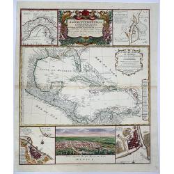
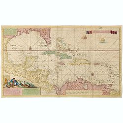
Mappa Geographica complectens. I. INDIAE OCCIDENTALIS partem mediam circum ISTHMUM PANAMENSEM. II. Ipsung Isthmuin. III. Ichnographiam praecipuorum locorum. . .
Six varying sized insets depict the West Indies: Panama, Saint Augustine, Vera Cruz, Santo Domingo, and a birds-eye view of Mexico City. The primary, largest inset map ha...
Date: Nuremberg, 1750
Selling price: ????
Please login to see price!
Sold in 2020
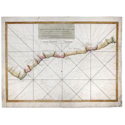
Carte Particuliere de la Coste d'Or pour servir aux Vaisseaux Du Roy.
An interesting map showing the coasts of Cote d'Ivoire, Guinee, Ghana and more. A fine early sea chart , published by the French Hydrographical Department. This chart was...
Date: Paris, 1750
Selling price: ????
Please login to see price!
Sold in 2020
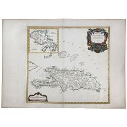
ISLES DE SAINT DOMINIGUE ou HISPANIOLA et de la Martinique.
This is a fine map of Hispaniola or Santo Domingo (modern day Haiti and the Dominican Republic) by Robert de Vaugondy. It includes the tip of Cuba and the Inagua Islands ...
Date: Paris, 1750
Selling price: ????
Please login to see price!
Sold in 2020
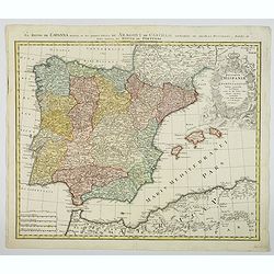
Regnorum Hispaniae et Portugalliae. . .
A beautifully detailed map of Spain and Portugal by Homann. It offers excellent detail of the Iberian Peninsula and the Balearic Islands, plus parts of southwestern Franc...
Date: Nuremberg, ca 1750
Selling price: ????
Please login to see price!
Sold in 2021
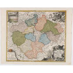
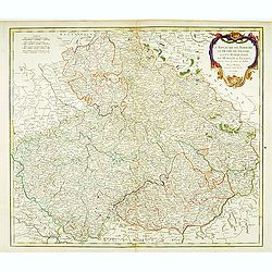
Mappa Geographica Totius Regni Bohemiae In XII Circulos divisae annexisComitatuGlacensi et Districtu Egerano . . .
Uncommon map of the Czech Republic, centered on Prague. Includes four ornate cartouches, coat of arms and a birdseye view of the Bridge across the Moldau River in Prague.
Date: Augsburg, 1750
Selling price: ????
Please login to see price!
Sold in 2020
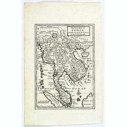
The East Part of India, or India beyond the R. Ganges.
Herman Moll's map of those Asian countries.
Date: London, ca 1750
Selling price: ????
Please login to see price!
Sold in 2020
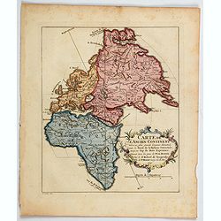
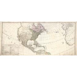
Carte de L'Ancien Continent. . .
An unusual map showing a north-south axis at an oblique angle to the continents. The map shows the old world of Africa, Europe and Asia from Russia to the Cape of Good Ho...
Date: Paris, ca 1750
Selling price: ????
Please login to see price!
Sold in 2020
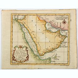
Carte de la Coste d'Arabie, Mer Rouge, et Golfe de Perse. . .
A pleasant map of the Arabian Peninsula, the Red Sea and the Gulf region, published in Paris during the mid 18th century. Published in the "Histoire générale des V...
Date: Paris, ca 1750
Selling price: ????
Please login to see price!
Sold in 2021
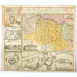
Regnum Bosniae , una cum finitimis Croatiae, Dalmatiae. . .
One half of a large two sheet map that covers from the Dalmatian coast to Walachia to the city of Nissa, including Bosnia, Serbia, Croatia, and parts of Slovenia and Bulg...
Date: Nuremberg, ca 1750
Selling price: ????
Please login to see price!
Sold in 2020
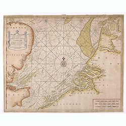
A Correct Chart Of The Sea Coasts Of England, Flanders And Holland Shewing The Sands Shoals Rocks And Dangers, The Bays Harbours Roads Buoys Beacons & Seamarks On The Said Coasts.
Mount & Page's chart of the Channel and contiguous British, Belgian and Dutch Coastlines. The imprint of "W.& J.Mount & T.Page" helps date this part...
Date: London, ca. 1750
Selling price: ????
Please login to see price!
Sold in 2020
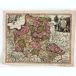
Poloniae Regnum ut et Magni Ducatus Lithuaniae . . .
Detailed map of Poland and the Baltic regions, extending in the south to Ukraine and northern Hungary.Matthaus Seutter the elder first published his "Atlas Geographi...
Date: Augsburg, 1740-1750
Selling price: ????
Please login to see price!
Sold in 2020
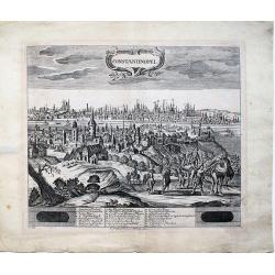
Constantinopel.
A very rare, extremely detailed view of IstanbuI that depicts the city from Galata with realistic scenes of every-day life. Both sides of the Golden Horn are delineated i...
Date: Dresden ca. 1750
Selling price: ????
Please login to see price!
Sold in 2023
Carte de la Tartarie Orientale. . .
A detailed copper engraved map of northeast Asia and Manchuria, showing the island "Sagallan Anga Hata" or "Isle de Bouche Noire". From Prevost's &quo...
Date: Paris, 1750
Selling price: ????
Please login to see price!
Sold in 2021
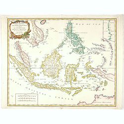
Archipel Des Indes Orientales, qui comprend Les Isles De La Sonde.. Philippines..
An attractive and detailed view of the Indonesian islands in large format. Decorative title cartouche.
Date: Paris, 1750
Selling price: ????
Please login to see price!
Sold in 2021
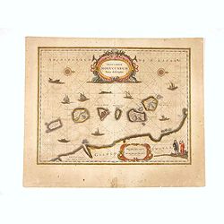
Insularum Moluccarum ..
Exquisite map of the famous Spice Islands based on the islands described by Jan Huyghen van Linschoten. This map was the first large scale map of the region and depicts t...
Date: Amsterdam, 1750
Selling price: ????
Please login to see price!
Sold in 2020
The Continent and Islands of America are divided and Possessed as follows. . .
A copper engraved map. Top half sheet of a 2-sheet map only. Printed in lower left corner is a key showing which regions and islands belong to the United States and Great...
Date: London, ca 1750
Selling price: ????
Please login to see price!
Sold in 2021

Painting of Tupinamba cannibals of Brazil set in a local landscape on wooden panel.
The iconography of this painting is derived from one of the plates illustrated in the third volume of "Grands Voyages" by Th. Bry taht was devoted to Brazil (Na...
Date: ca. 1750
Selling price: ????
Please login to see price!
Sold in 2023
![[An untitled Sea Chart of South Devon.]](/uploads/cache/46633-250x250.jpg)
[An untitled Sea Chart of South Devon.]
A large scale English Sea Chart of part of southern Devon in SW England. The chart is dominated by a very decorative dedication cartouche highlighting the landing of Will...
Date: London ca 1750
Selling price: ????
Please login to see price!
Sold in 2020
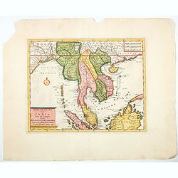
Nieuwe kaart van India over de Ganges, Malakka, Siam..
A nice detailed map, incorporating information provided by French Jesuits, of Indochina, the Malayan peninsular and the northern parts of Sumatra and Borneo. The mythical...
Date: Amsterdam, 1750
Selling price: ????
Please login to see price!
Sold in 2020
![Carte Generale Inserviente al Teatro della Guerra [...]a Lusazia, la Silesia divisa. . .](/uploads/cache/84695-250x250.jpg)
Carte Generale Inserviente al Teatro della Guerra [...]a Lusazia, la Silesia divisa. . .
A very rare map of the area around Wroclaw and Glatz, extending until Prague, Dresden, and Olomouc. With a title cartouche showing a small view. Further two putti holding...
Date: Venice, ca 1750
Selling price: ????
Please login to see price!
Sold in 2020
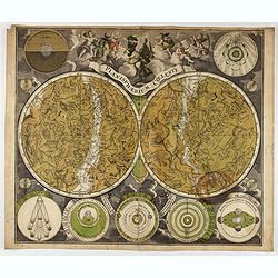
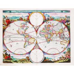
Planisphaerium Coeleste.
A very decorative double hemisphere celestial chart, centered on the North and South Poles, with smaller circular diagrams illustrating the theories of Tycho, Ptolemy, La...
Date: Augsburg, 1750
Selling price: ????
Please login to see price!
Sold in 2021
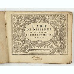
L'art de dessiner, par Jean Cousin, excellent peintre François.
Complete title: "L’art de dessiner, par Jean Cousin, revu, corrigé et augmenté de plusieurs morceaux d’aprés l’antique, avec leurs mesures & proportions...
Date: Paris, François Chereau, 1750
Selling price: ????
Please login to see price!
Sold in 2021
Voyage around World by Anson. -CARTE dans lequelleon voit la route que le Centurion a tenu. . .
A map of Anson's voyage around the world from the French edition of the voyage published in 1750. It was engraved by Lattre and is identical to the English edition "...
Date: Paris, 1750
Selling price: ????
Please login to see price!
Sold in 2021
Kaart van de Baay van Cadix met de Palan Fortificatien Ten Dienst der Zeevaart opgesteld door William May...
Scarce chart of the Bay of Cadiz, showing with large details towns, settlements, soundings, anchorages, etc., and an inset of the fortifications. There is a very decorati...
Date: Amsterdam, 1750
Selling price: ????
Please login to see price!
Sold in 2023
A Correct Chart of the Sea Coasts of England, Flanders, and Holland…
Nice example of Mount & Page's map of the Channel showing the coastlines of England, Belgium and Holland.Published at first in 1671-1672 in John Seller's 'The English...
Date: London, ca. 1750
Selling price: ????
Please login to see price!
Sold in 2021
![[Lot of 8 maps / views of Mexico] Ancien Mexico / Nouveau Mexico.](/uploads/cache/20705-250x250.jpg)
[Lot of 8 maps / views of Mexico] Ancien Mexico / Nouveau Mexico.
2 views of Mexico city, as in the times of the conquestedores and as in the 18th century.Plus 6 maps / views of Mexico. Together 8 items.
Date: c. 1750
Selling price: ????
Please login to see price!
Sold in 2022
![[Lot of 14 maps] Carte Generale de la Coste de la Guinée. Plus a map of the Gulf of Guinea on 2 sheets by Rigobert Bonne and 6 other maps of the Gulf of Guinea](/uploads/cache/18246-250x250.jpg)
[Lot of 14 maps] Carte Generale de la Coste de la Guinée. Plus a map of the Gulf of Guinea on 2 sheets by Rigobert Bonne and 6 other maps of the Gulf of Guinea
Jaques Nicolas Bellin (1702-720) was the most important French hydrographer of the 18th century. Sea-atlas 'Hydrographique Français' , 1756-65, atlas to accompany Prévo...
Date: Paris, 1750
Selling price: ????
Please login to see price!
Sold in 2024
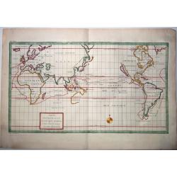
Orbis Terrarum Tabula Recens Emendata Et In Lucem Edita.
A world map in two hemispheres, decorated in the corners with the representations of the four continents in allegorical form.
Date: Amsterdam, c. 1750
Selling price: ????
Please login to see price!
Sold in 2022
![[Lot of 4 maps] Afbeeldinge der Oostersche Landen. / van ' T Land Kanaan.](/uploads/cache/100146-250x250.jpg)
[Lot of 4 maps] Afbeeldinge der Oostersche Landen. / van ' T Land Kanaan.
Willem Albert Bachiene (1712-1783), Dutch geographer in Maastricht. Most important work ' Heilige Geographie', a work on the Holy Land. A map of the Near East and a map o...
Date: Amsterdam, c. 1750
Selling price: ????
Please login to see price!
Sold in 2022
![[Lot of 10 maps and prints of Birma, Thailand and Malaysia.]](/uploads/cache/20085-(4)-250x250.jpg)
[Lot of 10 maps and prints of Birma, Thailand and Malaysia.]
A map of the Gulf of Bengal with the adjacent coasts of India and Sri Lanka, Bangla Desh, Birma, Thailand and Malaysia. Ref.: Gole, India within the Ganges, 62.11.1Jaques...
Date: Paris, Amsterdam, c. 1750
Selling price: ????
Please login to see price!
Sold in 2022
![[9 maps of Peru and Chili]](/uploads/cache/20641-(1)-250x250.jpg)
[9 maps of Peru and Chili]
A map of the Southamerican continent from the Dutch edition of Robertson's ' History of America'.Plus 8 maps of Peru and Chili
Date: London, ca. 1750
Selling price: ????
Please login to see price!
Sold in 2022
![[lot of 5 maps/prints map of South America] Chili. Paraguay, Brésil, Amazones, et Pérou.](/uploads/cache/19976-(2)-250x250.jpg)
[lot of 5 maps/prints map of South America] Chili. Paraguay, Brésil, Amazones, et Pérou.
Louis Brion de la Tour (1756-1823), ' Atlas Géneral, Civil et Ecclésiastique', 1766, ' Atlas Général', 1790-98. Louis Charles Desnos (fl.1750-70), Paris-based publish...
Date: Paris, c. 1750
Selling price: ????
Please login to see price!
Sold in 2022
![[Portrait of Petrus Bertius.]](/uploads/cache/48311-250x250.jpg)
[Portrait of Petrus Bertius.]
Portrait of Petrus Bertius (1565-1629). After a painting of R.Buys. Theologian, historian, geographer and cartographer. Bertius published much in mathematics, and histori...
Date: Amsterdam, 1750
Selling price: ????
Please login to see price!
Sold in 2022
![[Lot of 22 maps / prints] Kaart van Mexico en Nieuw Granada in de Spaansche West-Indien.](/uploads/cache/20690-(3)-250x250.jpg)
[Lot of 22 maps / prints] Kaart van Mexico en Nieuw Granada in de Spaansche West-Indien.
A detailed map showing the Caribbeans, the Gulf of Mexico with its adjacent lands and Central America.. Izaak Tirion (d. 1769) Amsterdam publisher. His ' Nieuwe en beknop...
Date: Amsterdam, c. 1750
Selling price: ????
Please login to see price!
Sold in 2022
![[Lot of 7 map / prints of Madagascar] Parte de la Cote Orientale d' Afrique avec l' Isle de Madagascar et les Cartes particulières des Isles de France et de Bourbon.](/uploads/cache/18022-(1)-250x250.jpg)
[Lot of 7 map / prints of Madagascar] Parte de la Cote Orientale d' Afrique avec l' Isle de Madagascar et les Cartes particulières des Isles de France et de Bourbon.
A map of Madagascar with 2 insets depicting Mauritius and Réunion. and the opposite mainland of Africa, nowadays Mocambique. The area around the Zambesi river, rich in g...
Date: Paris, c. 1750
Selling price: ????
Please login to see price!
Sold in 2022
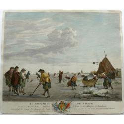
Winter pleasures on the Haarlemmer Lake with Haarlem in the distance.
Engraving By J. Aliamet, Les Amusements De L'Hiver. Rare 18th century Dutch golf engraving by J. Aliamet depicting Dutchman playing the early form of golf on the ice near...
Date: Paris, 1750
Selling price: ????
Please login to see price!
Sold in 2023
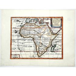
L AFRIQUE Dresse sur les Observations de Mrs de L'academie Royalle des Sciences. . .
A very fine, old color, decorative map of Africa, showing the Mediterranean and south Europe, Madagascar, Azores and Cape Verde. The Atlas was published on behalf of the ...
Date: Paris, 1751
Selling price: ????
Please login to see price!
Sold in 2019

Sculpture, Fonte des Statues Equestres . . . (PL IV).
The plate shows the steps in the casting of massive equestrian statues, one of the staples of public monuments before the twentieth century. As the rule with the plates i...
Date: Paris, 1751
Selling price: ????
Please login to see price!
Sold in 2019
Sculpture, Fonte des Statues Equestres . . . (suite de la PL III)
The plate shows the steps in the casting of massive equestrian statues, one of the staples of public monuments before the twentieth century. As the rule with the plates i...
Date: Paris, 1751
Selling price: ????
Please login to see price!
Sold in 2019
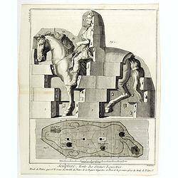
Sculpture, Fonte des Statues Equestres . . . (PL III)
The plate shows the steps in the casting of massive equestrian statues, one of the staples of public monuments before the twentieth century. As the rule with the plates i...
Date: Paris, 1751
Selling price: ????
Please login to see price!
Sold in 2020
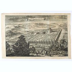
La ville de Babylone.
Eye bird view of the city of Babylone. Engraved by J.Punt. From "L'Histoire Universelle Depuis la Commencement du Monde, Jusqu'a Present, Traduit de L'Anglois D'Une ...
Date: Amsterdam, Arkstée et Merkus, 1751
Selling price: ????
Please login to see price!
Sold in 2021

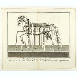
Sculpture, Fonte des Statues Equestres . . . (PL II)
The plate show the steps in the casting of massive equestrian statues, one of the staples of public monuments before the twentieth century. As the rule with the plates in...
Date: Paris, 1751
Selling price: ????
Please login to see price!
Sold in 2021
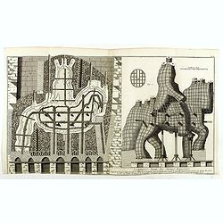
Sculpture, Fonte des Statues Equestres . . . (PL V)
The plate shows a step in the casting of a massive equestrian statue, one of the staples of public monuments before the twentieth century. As the rule with the plates in ...
Date: Paris, 1751
Selling price: ????
Please login to see price!
Sold in 2021

Sculpture, Fonte des Statues Equestres . . . (PL I)
The plate shows the steps in the casting of massive equestrian statues, one of the staples of public monuments before the twentieth century. As the rule with the plates i...
Date: Paris, 1751
Selling price: ????
Please login to see price!
Sold in 2021
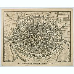
Bruges one of the Principal Cities of Flanders.
A birds-eye plan of the lovely Belgian city of Bruges, seen here within its ancient walls and fortifications. A number of bridges and windmills are shown, along with pict...
Date: London, ca 1751
Selling price: ????
Please login to see price!
Sold in 2023
Pascaerte van Rio Gambia Als meede het Vaerwater tussen Cabo Verde en Brazil.
A highly decorative sea chart of the Atlantic Ocean between Gambia, Cap Verde and Brazil. On top is a figurative scale cartouche flanked with putti and in the lower left...
Date: Amsterdam, 1751
Selling price: ????
Please login to see price!
Sold in 2023
Nouvelle Carte Marine de Toute les Cotes de l´Amerique montrant toutes les isles, Bayes et rivieres, aussi toutes les roches et profonts . . .
Rare chart of Florida, the Gulf Coast, Caribbean and Central America, with great detail through the region, including dangerous rocks, soundings, etc.Florida shows a bit ...
Date: Amsterdam, 1728 - 1751
Selling price: ????
Please login to see price!
Sold
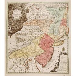
Pensylvania, Nova Jersey et Nova York..
One of the few maps to concentrate on this area and one of the most bizarre maps of North America ever published. The entire coastline is highly inaccurate; New Hampshire...
Date: Augsburg c.1751
Selling price: ????
Please login to see price!
Sold
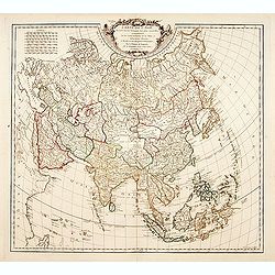
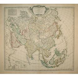
Carte de l'Asie dressé sur les relations les plus..
Standard map of Asia, with good detail.
Date: Paris, 1751
Selling price: ????
Please login to see price!
Sold
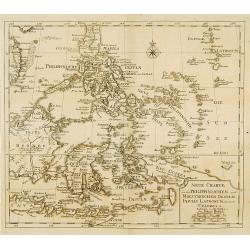
Neue Charte von dem Philippinischen und Moluckischen Insuln..
Very rare map of South East Asia including the Philippines, Moluccas, New Guinea, parts of Borneo, and Java. The map is a faithful copy of Isaac Tirion's map of a few yea...
Date: Altona, 1751
Selling price: ????
Please login to see price!
Sold
Le royaume de Boheme, le Duché de Silésie..
Covering Czech Republic, embellished with decorative title cartouche.
Date: Paris, 1751
Selling price: ????
Please login to see price!
Sold in 2008
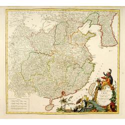
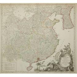
L'Empire de la Chine..
Detailed map of China, Korea and Taiwan. Decorative cartouche lower right.
Date: Paris 1751
Selling price: ????
Please login to see price!
Sold
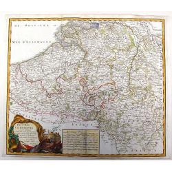
Pays-Bas Catholiques.
Nice, detailed, copper engraved map of the region of present day Belgium and Luxembourg. A fine military themed cartouche with a large fancy cartouche. Gilles Robert de V...
Date: Paris, 1751
Selling price: ????
Please login to see price!
Sold in 2015
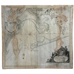
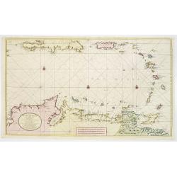
Nieuwe Afteekening van het Eyland Curacao vertoonende alle desselfs geleegentheden mitsgaders de haven van St. Anna en 't Fort Amsterdam int grood, als ook hoe sig dit Eyland uyt der zee vertoont
Decorative and extremely rare of Curaçao with several coastal insets and an inset of Fort Amsterdam and the Bay of St.Anna (127x135mm.)Besides the island of Curacao, th...
Date: Amsterdam, 1751
Selling price: ????
Please login to see price!
Sold in 2017
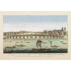
A North viewe of Westminster Bridge.
So-called optical print illustrating a North view of Westminster Bridge with vessels on the River Thames.In the eighteenth and nineteenth centuries there were many popula...
Date: London 1751
Selling price: ????
Please login to see price!
Sold
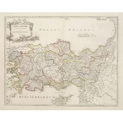
Asia Minor in suas partes seu provincias divisa..
Detailed map of Cyprus, Asia Minor and contiguous Islands and the Black Sea region.
Date: Paris 1751
Selling price: ????
Please login to see price!
Sold
Nieuwe en.. West Indien .. Rio Oronoque tot ..Porto Rico..
A highly detailed and rare chart of the coast of Columbia, Venezuela and its islands, Bonaire, Curaçao, Aruba, and several Caribbean Islands, Puerto Rico, Southern coast...
Date: Amsterdam 1751
Selling price: ????
Please login to see price!
Sold
![Les Ports de, Lisbonne [. . .] Le Detroit de Gibraltar...Cadis](/uploads/cache/90434-250x250.jpg)
Les Ports de, Lisbonne [. . .] Le Detroit de Gibraltar...Cadis
A finely engraved two section map of the Lisbon coast / Setubal area of Portugal and Cadiz / Straights of Gibraltar in Spain. The work contains two elaborate cartouches a...
Date: Paris, ca. 1751
Selling price: ????
Please login to see price!
Sold in 2008
L'Empire de la Chine ...
Detailed map of China, Korea and Taiwan. Decorative cartouche lower right.
Date: Paris, 1751
Selling price: ????
Please login to see price!
Sold in 2011
Carte du Canal des Iles Philippines. . . Page 88.
Important large-scale map of the northern Philippines, from Luzon to Negros, featuring the track of the Manila Galleon on its yearly treasure voyage from Manila to Mexico...
Date: Amsterdam, 1751
Selling price: ????
Please login to see price!
Sold in 2008
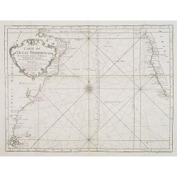
Carte de l'Ocean Meridional. . .
Map of the southern Atlantic Ocean including South America and South African coastlines. From "Voyage Autour du Monde, Fait dans les Années MDCCXL, I, II, III, IV. ...
Date: Amsterdam, 1751
Selling price: ????
Please login to see price!
Sold in 2008
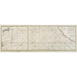
Carte de la Mer du Sud ou Mer Pacifique / Kaart van de ZUYD - ZEE of STILLE OCEAAN. . .
Map of the Pacific Ocean from the Northern Marianas Islands to the Californian and Mexican coastline. Important large-scale map of the Pacific Ocean. From \"Voyage A...
Date: Amsterdam, 1751
Selling price: ????
Please login to see price!
Sold in 2009
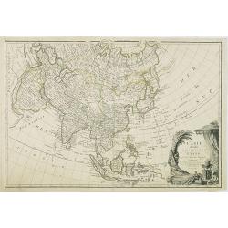
Carte de L\'Asie dressée sur les Relations les plus nouvelles principalement..
Detailed map of Asia from the Atlas Universel , first published in 1755. The map is detailed, precisely engraved and not given to the fanciful cartography being promoted ...
Date: Paris, 1751
Selling price: ????
Please login to see price!
Sold in 2010
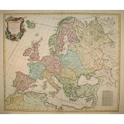
L'Europe divisée en ses principaux Etats?
A detailed map from the Atlas Universel. The map is precisely engraved and not given to the fanciful cartography being promoted by many of the other contemporary French t...
Date: Paris, 1751
Selling price: ????
Please login to see price!
Sold in 2009

Instructie Ende Ordre op het houden van de scheeps-soldy en guarnisoens-boeken...
Contains instructions and orders concerning bookkeeping of the ship's pay and the monthly payments, testaments loans, etc., of V.O.C. employees. It is based on a Resoluti...
Date: Amsterdam, 1751
Selling price: ????
Please login to see price!
Sold
L'ASIE divisée en ses principaux ETATS par le Sr. Janvier, G
This fine map presents a fairly accurate and modern outline of Asia. The Bering Straits are identified as Detroit du Nord ou d'Anian.The map is of interest for the use of...
Date: Paris, 1751
Selling price: ????
Please login to see price!
Sold in 2010
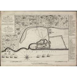
A Plan of Madras and Fort St. George, Taken by the French, Commanded by Monsieur Martre de la Bourdonnais. / Plan de Madras et du Fort St. Georges, pris parles Francois, Commandes par Mr. Matre de la Bourdonnais
A very rare plan of Madras during the Carnatic WarsThis copper engraved plan of Madra in India was published by John Rocque in 1751 and engraved by one of his employees R...
Date: London, 1751
Selling price: ????
Please login to see price!
Sold in 2010
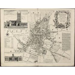
A Plan of Wolverhampton Surveyed in MDCCL By Isaac Taylor and Engraved by Thomas Jefferys Geographer to His Royal Highness the Prince of Wales
Important and rare plan of Wolverhampton by T. JefferysA large and detailed copper engraved plan of Wolverhampton, engraved and published by Thomas Jefferys in 1751 after...
Date: London, 1751
Selling price: ????
Please login to see price!
Sold in 2010
Nieuwe Afteekening van het Eijland Curaçao. . .
Decorative and extremely rare chart of Curaçao with several coastal insets and an inset of Fort Amsterdam and the Bay of St.Anna (127x135mm.)Besides the island of Curaca...
Date: Amsterdam, 1751
Selling price: ????
Please login to see price!
Sold in 2010
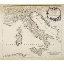
Italia antiqua cum insulius Sicilia, Sardinia et Corsica. . .
Map of Italy, including the islands of Corsica, Sardinia and Sicilia. Published by Robert Vaugondy (son 1723-1886) after a map by Nicolas Sanson.Map shows the ancient div...
Date: Paris, c.1751
Selling price: ????
Please login to see price!
Sold in 2010
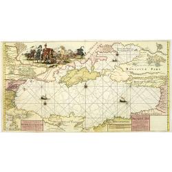
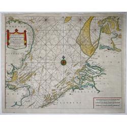
Nieuwe Paskaart van de gehele Swarte Zee Beginnende van Constantinopolen tot Azak opgestelt door G: van Keulen. . .
A highly detailed and rare chart of the Black Sea.A large title cartouche upper left, and a dedication to Peter Alexeowits (the Great).
Date: Amsterdam, 1751
Selling price: ????
Please login to see price!
Sold in 2010
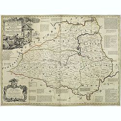
An accurate map of the county Palatine of Durham. . .
Scarce pre-atlas issue of 'The Large English Atlas' map of County Durham, published by John Hinton in 1751. Decorative cartouche around the title. Important and influenti...
Date: London, 1751
Selling price: ????
Please login to see price!
Sold in 2017
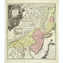
Pensylvania, Nova Jersey et Nova York..
Pre-Revolutionary War era map based on Lewis Evans’ map of 1749 and one of the few maps to concentrate on this area and one of the most bizarre maps of North America ev...
Date: Augsburg, c.1751
Selling price: ????
Please login to see price!
Sold in 2011
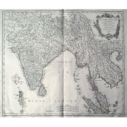
Les Indes Orientales ou sont distingues les Empires et Royaumes quelles contiennent, tirees du Neptune Oriental.
An early edition of Robert de Vaugondy's map from his Atlas Universel. Reaches from Pakistan (with Candahar and Caboul) to Sumatra and Singapore. Includes India, the Male...
Date: Paris, 1751
Selling price: ????
Please login to see price!
Sold in 2011