Browse Listings
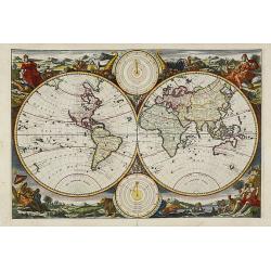
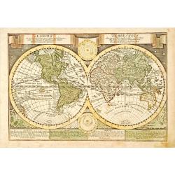
Werelts.
A beautiful world map from a Dutch Bible published by the Keur family, this is probably the most decorative of Dutch Bible maps. The map is surrounded by allegorical repr...
Date: Amsterdam, 1748
Selling price: ????
Please login to see price!
Sold in 2019
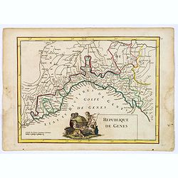
Republique de Genes.
A nice map of northwest Italy and the Gulf of Genoa, at left Nice and Monaco, there is a nice putti-scene in the sea, reflecting Genoese exploration and discovery around ...
Date: Paris, 1748
Selling price: ????
Please login to see price!
Sold in 2019
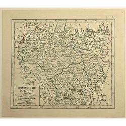
Royaume de Pologne Divisee en Haute et Basse Pologne ...
Fine example of De Vaugondy's map of the Kindgom of Poland, from his “Atlas Portatif. . . ,” first published in Paris in 1748.Gilles Robert de Vaugondy (1688–1766),...
Date: Paris, 1748
Selling price: ????
Please login to see price!
Sold in 2019
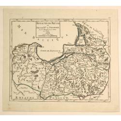
Royaume de Prusse et Prusse Rle. ou Ponolaise.
This is a pleasing map of Prussia by Robert de Vaugondy. It covers the northeastern part of Poland and extends from Grodno and the Spirding-See in Poland north to Klaiped...
Date: Paris, 1748
Selling price: ????
Please login to see price!
Sold in 2019
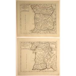
Partie Meridionale (and Septentrionale) du Royaume de Portugal. (2 Maps)
Two small detailed maps encompassing the whole of Portugal. From Atlas Portatif Universel, by Vaugondy. Numbered plate 50 and 51 in the top right corner. Gilles Robert ...
Date: Paris, 1748
Selling price: ????
Please login to see price!
Sold in 2020
![[2 prints] The inside perspective view of the under Chappel... / A view of the west front of the Chappel...](/uploads/cache/82580-250x250.jpg)
[2 prints] The inside perspective view of the under Chappel... / A view of the west front of the Chappel...
Two quite rare attractive copper-engravings of the St. Thomas Chapel on the old London Bridge. Engraved by James Basire, drawn by George Vertue, published in the first vo...
Date: London, 1748
Selling price: ????
Please login to see price!
Sold in 2019
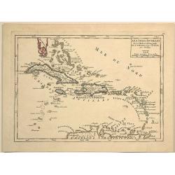
Les Isles Antilles.
Pleasing example of De Vaugondy's scarce map of the Caribbean. Note how Florida looked in the upper left corner. The map appeared in Vaugondy's "Atlas Portatif.&quo...
Date: Paris, 1748
Selling price: ????
Please login to see price!
Sold in 2023
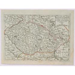
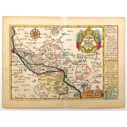
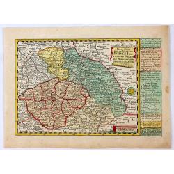
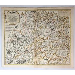
Royaume de Boheme, Marqui de Moravie et Silesie Autrichienne.
A fine 1748 map of Bohemia, Moravia and Silesia by Robert de Vaugondy. It covers modern day Czech Republic as well as parts of Germany and Poland. It extends from Leipzig...
Date: Paris, 1748
Selling price: ????
Please login to see price!
Sold in 2019
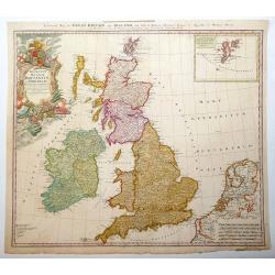
Regnorum Magnae Britanniae et Hiberniae.
Issued over a long period by the heirs of Johann Baptist Homann. This handsome map of the British Isles includes very good detail of Ireland, England, Scotland, Wales, an...
Date: Nuremberg, 1749
Selling price: ????
Please login to see price!
Sold in 2013
A New and Correct Chart of the Sea Coast of ENGLAND SCOTLAND & IRELAND Sold by George Grierson at the Two Bibles & Kings Arms in Essex Street Dublin
Scarce chart of England, Scotland and Ireland, engraved by James Barlow and published by George Gierson in Dublin. It is copied from Samuel Thornton's chart, 1708, for an...
Date: Dublin, 1749
Selling price: ????
Please login to see price!
Sold in 2012
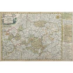
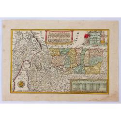
Der Fraenckishe Creis.
Der Fraenckishe Creis by Johann George Schreiber. The map is high in detail the cartouche is surrounded by two cherubs. From Schreiber's "Atlas Selectus". E...
Date: Leipzig, 1749
Selling price: ????
Please login to see price!
Sold in 2014
Das Aml Gommern und Die Graffschassl Barby Zu Fiden Bey.
Striking detailed map of Gommern and the Elbe River in Germany. It has two fancy cartuches, one with two children playing, and a interesting detailed compass rose. The to...
Date: Leipsig, 1749
Selling price: ????
Please login to see price!
Sold in 2015
Reise Charte Durch Nieder Sachen
Nicely detailed map of Lower Saxony from "Atlas Selectus". On the right are explanations of political situations. Johann Georg Schreiber (1676 – 1745), a Ger...
Date: Leipzig, 1749
Selling price: ????
Please login to see price!
Sold in 2014
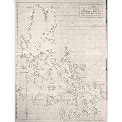
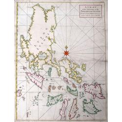
A Chart of the Channel in the Phillippine Islands through which the Manila Galeon passes together with the adjacent Islands.
Chart of the northern Philippine islands. Double page chart, engraved by R. W. Seale, from the English edition of George Anson's Voyages, London 1749.
Date: London, 1749
Selling price: ????
Please login to see price!
Sold in 2013
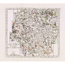
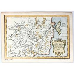
Carte Générale du Duché de Luxembourg.
Charming small map representing the Duchy of Luxembourg. Centered on Bastogne. Divided into 11 sections.From Atlas Portatif Universel, by Robert de Vaugondy. Edited by : ...
Date: Paris, later than 1749
Selling price: ????
Please login to see price!
Sold in 2013
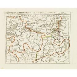
VI. Carte du D.ché de Luxembourg.. Seigneurie de Pruym.
Charming small map representing part of Rhineland-Palatinate, close to the border with Luxembourg.From Atlas Portatif Universel, by Robert de Vaugondy. Edited by : "...
Date: Paris, later than 1749
Selling price: ????
Please login to see price!
Sold in 2013
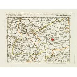
VIII. Carte du D.ché de Luxembourg.. Environs d'Arlon.
Charming small map representing part of Luxembourg, the southernmost province of Wallonia and of Belgium. Centered on Arlon.From Atlas Portatif Universel, by Robert de Va...
Date: Paris, later than 1749
Selling price: ????
Please login to see price!
Sold in 2020
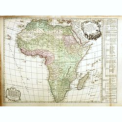
L'Afrique divisé en ses principaux et Royaumes.
This is the uncommon first state. With table to the right. First issued in 1749 and it went through at least seven states with editions appearing as late as 1810. The sta...
Date: Paris, 1749
Selling price: ????
Please login to see price!
Sold in 2018
Globus ex probatisimis . . . .. / Terrestris phorum Observationibus. . .
Double hemisphere world map, in lower part of the map four blocks describing the different continents. With two celestial diagrams with depictions of the solar system bas...
Date: Leipzig, 1749
Selling price: ????
Please login to see price!
Sold in 2023
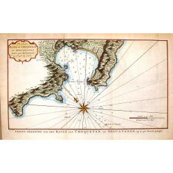
Plan du Havre de Chequetan ou Seguataneo.
Fine hand-colored map of present day Zihuatanejo, Mexico. It comes from a Dutch edition of Anson's "VOYAGE AROUND THE WORLD". The compass rose is striking.
Date: Amsterdam, 1749
Selling price: ????
Please login to see price!
Sold in 2016
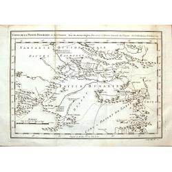
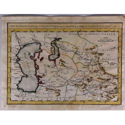
Carte de la Petite Bukharie et Pays Voisins.
Fine copper engraved map covering entire Sinkiang, the Tarim Basin, Djungariet and Turfan and the Pamirs in the west to the Chinese Wall beginning in the East. Engraved b...
Date: Paris, 1749
Selling price: ????
Please login to see price!
Sold in 2016
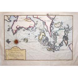
Carte de L'isle de Cheu-Chan.
Striking map of the area of China, east of Ningbo in Chekiang Province across from Shanghai. The map was by Bellin in 1749. Interestingly, the large, detailed compass ...
Date: Paris, 1749
Selling price: ????
Please login to see price!
Sold in 2019
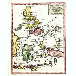
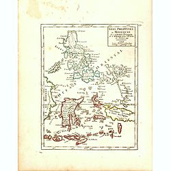
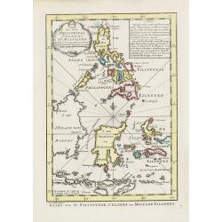
Isles Philippines et Moluques. . .
Fine miniature map of Philippines, Moluccas and New Guinea. Found in his Atlas Portatif, universel et militaire, 1749-1799.
Date: Paris, 1749
Selling price: ????
Please login to see price!
Sold in 2015
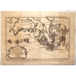
l'Isle de Cheu-chan ou Isle de Chusan.
A striking map of of Cheu-Chan in the province of Che-Kiang and surrounding islands in China. It was published in "HISTOIRE GENERALE DES VOYAGES" by Prevost in ...
Date: Paris, 1749
Selling price: ????
Please login to see price!
Sold in 2019
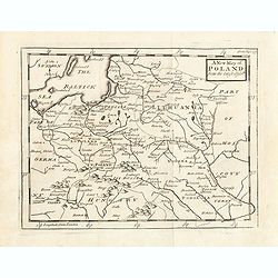
A New map of Poland from the lastest observe.
Map of Poland, Lithuania. Uncolored copper-engraved map, printed in 1749. No cartographer's name was given, possibly by Senex. Shows the Polish kingdom (including Lithuan...
Date: London, 1749
Selling price: ????
Please login to see price!
Sold in 2015
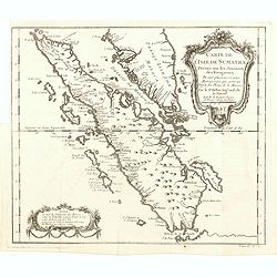
Carte de l'Isle de Sumatra. . .
Map of Sumatra, also showing the tip of the Malay Peninsula and the Straits of Singapore. An unusually detailed map of the area, showing many coastal features, shoals, ba...
Date: Paris, 1749
Selling price: ????
Please login to see price!
Sold in 2016
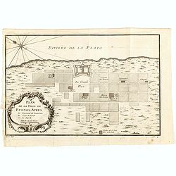
Plan de la Ville de Buenos Ayres.
The early layout of the town of Buenos Aires is shown in blocks, with a few of the important buildings named. Rococo title cartouche at lower left.Jacques Nicolaas Bellin...
Date: Paris, 1749
Selling price: ????
Please login to see price!
Sold in 2016
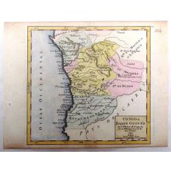
Congo ou Basse Guinee.
Little hand colored Vaugondy map featuring a section of the west coast of Africa, centered on Angola. It is from "Atlas Portatif, Universel et Militaire", publi...
Date: Paris, 1749
Selling price: ????
Please login to see price!
Sold in 2016
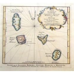
Carte des Isles de Johanna ou Anjouan Mohilla ou Moaly et Mauote.
Decorative map of the Comoros Islands to the north of Madagascar east of Africa. The map maker was N. Belin and the engraver was J. Van Der Schley.
Date: Paris, 1749
Selling price: ????
Please login to see price!
Sold in 2016
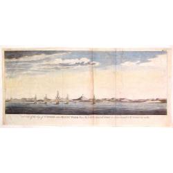
A View of the Bay of St. Julian When Mount Wood Bears W.S.W. 1/2 S and he Port or Rivers Mouth S.W. Distant Ten Miles.
Fine river view with ships in the Bay of St. Julian in South America. From "ILLUSTRATUIONS DE A VOYAGE ROUND THE WORLD IN THE YEARS MDCCXL" by George Anson. Eng...
Date: London, 1749
Selling price: ????
Please login to see price!
Sold in 2019
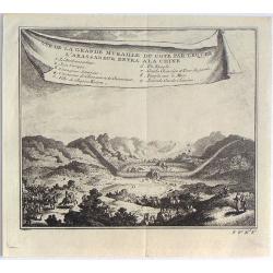
Vue de la Grande Muraille du Cote par Lequel L'Ambassadeur Entra a la Chine.
Fine little copper engraving from "HISTOIRE DES VOYAGES" by Abbe Prevost. It was published by Didot in Paris in 1748. Interesting banner cartouche.
Date: Paris, 1749
Selling price: ????
Please login to see price!
Sold in 2016
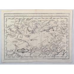
Carte de la Tartarie Orientale Pour Servir a L'Histoire Generale des Voyages.
Detailed map of Manchuria and the Northeast portion of Tartaria, including Sagallan Anga Hata. Produced by Nichlas Bellin for Prevost d'Exiles' “L'Histoire Generale de...
Date: Paris, 1749
Selling price: ????
Please login to see price!
Sold in 2019
Die Hertzogthümer Curland und Liefland...
Unusual map of the Baltic area which nowadays is mainly covered by Latvia and Estonia. Extends from Libau to St. Petersburg in Russia, including Riga, Revel (Tallinn), Na...
Date: Leipzig, 1749
Selling price: ????
Please login to see price!
Sold in 2016
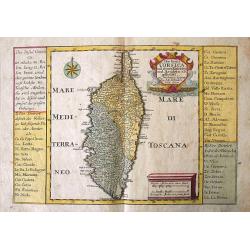
Die Insul Corsica mit dessen Disricten und Aemtern abgetheilet.
A very detailed map of the island of Corsica. Filled with place names, rivers, and hills. Embellished with the title cartouche, a distance scale, and a compass rose. To t...
Date: Leipzig, 1749
Selling price: ????
Please login to see price!
Sold in 2016
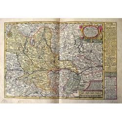
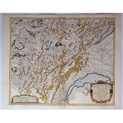
Das meiste von der Lombardey als Meyland, Parma und Piacenza...
Rare map of Lombardy, Piemont, Aosta, Liguria, and Ticino in Switzerland. With the Lago Maggiore, Lago di Como, Lago di Garda, Lago d'Iseo. Extends from Torino to Verona,...
Date: Leipzig, 1749
Selling price: ????
Please login to see price!
Sold in 2017
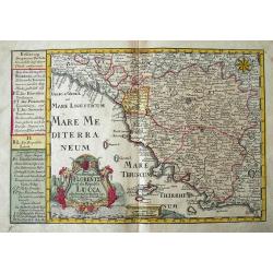
Das Groshertzogthum Florentz und die Republic Lucca...
Fine map of Tuscany. Extends from Genoa until Civitavecchia, and inland until Cervia. With Elba and Isola del Giglio. Filled with place names, such as Florence, Siena, Lu...
Date: Leipzig, 1749
Selling price: ????
Please login to see price!
Sold in 2018
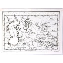
Carte de Karazm, Turkestan et Grand Bukarie
A fine copper engraved map by Bellin, centred on Uzbekistan, showing the Caspian and Aral seas. Published in “ Histoire Generale des Voyages” by Abbe A. F. Prevost in...
Date: Paris, 1749
Selling price: ????
Please login to see price!
Sold in 2019
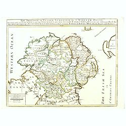
The Province of Ulster Surveyed by Sir William Petty. . .
This map of Ulster (present-day Northern Ireland), published in London by T.Jefferys is based on the Down Survey of Ireland undertaken in 1656–1658. As indicated in the...
Date: London, ca. 1749
Selling price: ????
Please login to see price!
Sold in 2016
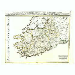
The Province of Munster Surveyed By Sr. William Petty : Divided into its Counties and the Counties into their serevall Barronies, Wherein are distinghished the . . .
This map of Ulster (present-day Northern Ireland), published in London by T.Jefferys is based on the Down Survey of Ireland undertaken in 1656–1658. As indicated in the...
Date: London, ca. 1749
Selling price: ????
Please login to see price!
Sold in 2016
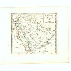
L'Arabie Par le Sr. Robert de Vaugondy fils de Mr. Robert Geog. ord du Roi avec Privilege 1749.
Small detailed map of Arabia. From Atlas Portatif Universel, by Robert de Vaugondy.Page 162 outside border top right. First and only state.More about Mapping of Arabia [+...
Date: Paris, 1749
Selling price: ????
Please login to see price!
Sold in 2017
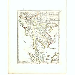
Presqu Isle fr L'Inde au dela du Gange ou sont les R.mes dAva, De Siam, De Tong-King, de Cochinchine de Cambodge, &c. Par le Sr. Robert de Vaugondy fils de Mr. Robert Geog. Ord du Roi avec Privilege 1749.
Small detailed map of Thailand, Cambodia, Malaysia. From Atlas Portatif Universel, by Robert de Vaugondy.Page 165 outside border top right. First and only state.
Date: Paris, 1749
Selling price: ????
Please login to see price!
Sold in 2016
Isles Philippines et Moluques Par le Sr. Robert de Vaugondy fils de Mr. Robert Geog. Ord du Roi avec Privilege 1749.
Small detailed map of Philippines, including New Guinee and Moluccas. From Atlas Portatif Universel, by Robert de Vaugondy.Page 169 outside border top right. First state ...
Date: Paris, 1749
Selling price: ????
Please login to see price!
Sold in 2016
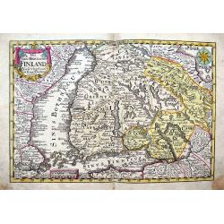
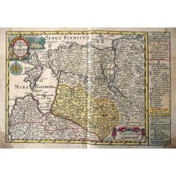
Das Gros=Hertzogthum Finland...
Very detailed map of southern Finland until Oulo, extending to include parts of Sweden with Stockholm, Revel (today Tallinn), St. Petersburg, and a part of the White Sea ...
Date: Leipzig, 1749
Selling price: ????
Please login to see price!
Sold in 2017
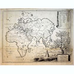
Afbeeldinge der Oude Waereld...
Map of the ancient world. Tower of Bable. Descendants of Noach.
Date: Amsterdam, 1749
Selling price: ????
Please login to see price!
Sold in 2016
Das Gelobte LandSsammt der 40 Jærigen Reise de Kinder Israel aus Egypten.
A pleasant map of the Holy Land by George Schrieber. Published in the 'Atlas Selectus', orientated with north to the right. With decorative cartouches for title and key f...
Date: Leipzeg, 1749
Selling price: ????
Please login to see price!
Sold in 2021
A Chart of the Channel in the Phillippine Islands...
A very attractive copper-engraved sea-chart, one of the best obtainable maps of Philippines from the 18th century. Covers the area from Luzon south until Negros, Cebu, an...
Date: London, 1748-1749
Selling price: ????
Please login to see price!
Sold in 2016
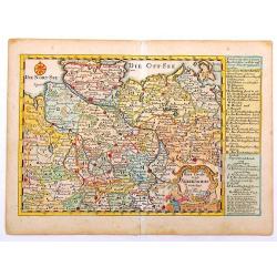
Reise Charte durch das Konigreich Bohmen Hertzogthum Schlesien.
A hand colored map showing the region which is now southern Poland and the Czech Republic with the cities of Prague, Olmutz (Olomouc), and Breslaw (Wroclaw). Includes exp...
Date: Leipzeg, 1749
Selling price: ????
Please login to see price!
Sold in 2018
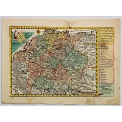
Reise Charte Durch Deutschland.
A pleasing map of Germany by George Schriebern, published in the 'Atlas Selectus' with explanatory text and directory on the right of map With decorative title cartouche ...
Date: Leipzeg, 1749
Selling price: ????
Please login to see price!
Sold in 2018
![[2 sheet wall map] Afrique publiée sous les auspices de Monseigneur le Duc d'Orléans Prémier Prince du Sang..](/uploads/cache/39670-250x250.jpg)
[2 sheet wall map] Afrique publiée sous les auspices de Monseigneur le Duc d'Orléans Prémier Prince du Sang..
A large, two sheet folding map of Africa, can be joined to make a wall map. Prepared and published by the great Jean Baptiste Bourguignon d'Anville (1697-1782).An ornamen...
Date: Paris, 1749
Selling price: ????
Please login to see price!
Sold in 2017
Partie Meridionale du Comte de Bourgogne ou Franche-Comte...
A striking map of the Burgundy (Bourgogne) and southern Franche-Comte region of eastern France by Robert de Vaugondy, published in 1749.It covers part of the southern Fra...
Date: Paris, 1749
Selling price: ????
Please login to see price!
Sold in 2018
Partie Septentrionale du Comte de Bourgogne ou Franche Comte...
A striking, detailed map of the Burgundy and northern Franche-Comte region of eastern France by Robert de Vaugondy. It covers the modern day departments of Doubs, Haute-S...
Date: Paris, 1749
Selling price: ????
Please login to see price!
Sold in 2018
Carte de Karasm, Turkestan et Grand Bukarie...
The Timurids. A Central Asian Sunni Muslim dynasty, of Turko-Mongol descent, whose empire included the whole of Iran, modern Afghanistan, and modern Uzbekistan, as well a...
Date: Paris, 1749
Selling price: ????
Please login to see price!
Sold in 2021
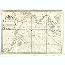
Carte de l'Ocean Oriental ou Mer des Indes. . .
Jacques Nicolas Bellin (1702-720) was the most important French hydrographer of the 18th century. Sea-atlas 'Hydrographique Français' , 1756-65, atlas to accompany Prév...
Date: Paris, ca 1749
Selling price: ????
Please login to see price!
Sold in 2020
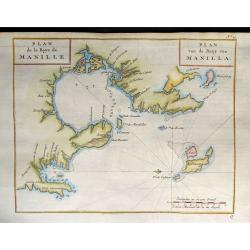
Carte de la Baye de Manille / Plan van de Baay van Manilla.
This attractive chart of Manila Bay comes from a more rare Dutch/French edition of Anson's Voyage Around the World (´Voyage autour du Monde´), published in 1749 in Amst...
Date: Amsterdam, 1749
Selling price: ????
Please login to see price!
Sold in 2019
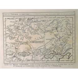
Carte de la Tartarie Occidentale. . .
A detailed copper engraved map of northeast Asia and Siberia, from Lake Baykal. Partie du Siberie in the north, Pays des Kalkas at the centre as well as Desert de Sable, ...
Date: Paris, 1749
Selling price: ????
Please login to see price!
Sold in 2019

Le Nom De Systeme.
A decorative armillary sphere, published in Paris by Le Rouge. The primary image is surrounded by 4 models of the solar system, based upon Copernicus, Ptolemee, Ticho-Bra...
Date: Paris, 1749
Selling price: ????
Please login to see price!
Sold in 2019
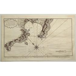
Plan of Havre de Chequetan ou Seguataneo. . .
A fine map of present day Zihuatanejo, Mexico. It comes from a Dutch edition of Anson's "VOYAGE AROUND THE WORLD". The compass rose is striking. It features a d...
Date: London, ca 1749
Selling price: ????
Please login to see price!
Sold in 2019
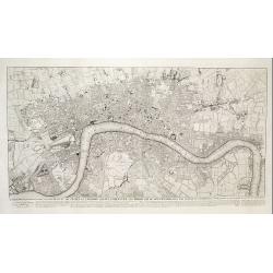
![To Martin Folkes Esq[ui]r[e] President of the Royal Society: This Plan of the Cities of London with the Contiguous Buildings. . .](/uploads/cache/83535-250x250.jpg)
To Martin Folkes Esq[ui]r[e] President of the Royal Society: This Plan of the Cities of London with the Contiguous Buildings. . .
A plan of London, Westminster and Southwark published in London in 1749. The text below the plan states that the map was taken from Rocque’s great survey of the city, t...
Date: London, 1749
Selling price: ????
Please login to see price!
Sold in 2020
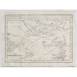
Carte de la Petite Bukarde et Pays Voisins. . .
Antique map of Central Asia (Turpan) of China. Petit Bukaharie or Xinjiang, known for the more two thousand years old Silk road. By Bellin in 1749.Jacques Nicolas Bellin ...
Date: Paris, 1749
Selling price: ????
Please login to see price!
Sold in 2020
Carte de la Tartarie Occidentale pour Servir a L'Histooire General des Voyages.
A detailed map of Western Tartary, including Siberia, the Sable Desert, Mongolia and part of Northern China. Showing roads, towns, rivers, lakes, mountains, etc. In the c...
Date: Paris, 1749
Selling price: ????
Please login to see price!
Sold in 2021
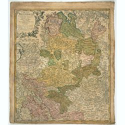
Circuli Westphaliae. . .
Johann Baptist Homann's well-engraved map has a large decorative cartouche. Detailed map of the south-western part of Poland covering the towns of Legnica, Wroclaw, Opole...
Date: Nuremberg 1749
Selling price: ????
Please login to see price!
Sold in 2022

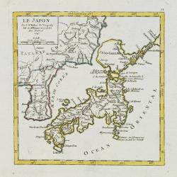
Le Japon.
The map is of interest for the use of Mer de Corée, for the sea between Korea and Japan. Small detailed map of Japan and Korea. Dated 1749. A note next to island &quo...
Date: Paris, 1749
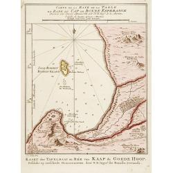
Carte de la Baye de la Table .. / Cap de Bonne Esperance.
A very nice map of the Cape of Good Hope.From Atlas Portatif pour servir a l'intelligence de l'Histoire Philosophique et Politique des etablissements et du commerce des E...
Date: Amsterdam 1749
Selling price: ????
Please login to see price!
Sold
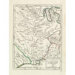
Cours du Mississipi et La Louisiane. . .
Fine map depicting Mississippi delta and Great Lakes in upper right hand corner, from Atlas Portatif, Universel Et Militaire , first published in 1749.Map dated 1749.
Date: Paris, 1749
Selling price: ????
Please login to see price!
Sold in 2021
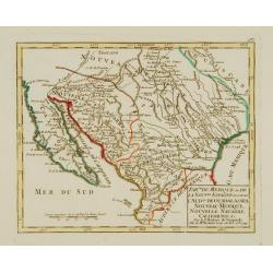
Partie du Mexique ou de la Nouv.le Espagne ouse trouve..
Fine miniature map of California Peninsular, Mexico till the Gulf of Mexico. Found in his Atlas Portatif, universel et militaire, 1749-1799.
Date: Paris 1749
Selling price: ????
Please login to see price!
Sold
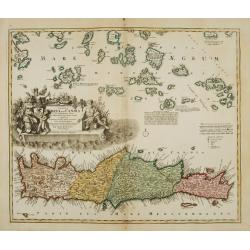
Insula Creta hodie Candia.
Johann Baptist Homann's well-engraved map has a large decorative cartouche. Detailed map of Crete.Johann Baptist Homann (1663-1724) was a German engraver and publisher, w...
Date: Nuremberg 1749
Selling price: ????
Please login to see price!
Sold
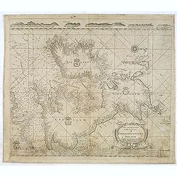
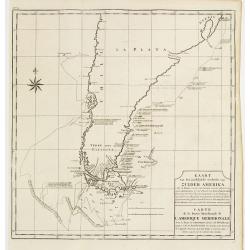
Carte de la partie meridionale avec la route du Centurion, depuis l'Isle Ste. Catherine..
This fine chart shows the route of Capt. George Anson's ship The Centurion down the east coast of South America from St. Catherine's Island off the coast of Brazil, down ...
Date: Amsterdam 1749
Selling price: ????
Please login to see price!
Sold
Le Japon.
Fine miniature map in a second state. Major cartographical corrections are the reduction of the size of Terred' Yedso and renaming it Jeso-Gasima , and the addition of fu...
Date: Paris 1749
Selling price: ????
Please login to see price!
Sold
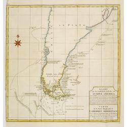
Kaart van het Zuidelykste Gedeelte van Zuider Amerika.. - Carte de la Partie Meridionale de l'Amerique Meridionale..
This fine chart shows the route of Capt. George Anson's ship "The Centurion" down the east coast of South America from St. Catherine's Island off the coast of B...
Date: Amsterdam, ca 1749
Selling price: ????
Please login to see price!
Sold in 2012
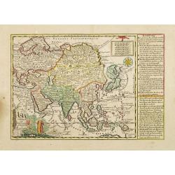
Asia verfertiget von Joh.Schreibern in Leipzig.
On this map Hokkaido is even bigger depicted than Honshu.
Date: Leipzig, 1749
Selling price: ????
Please login to see price!
Sold in 2009
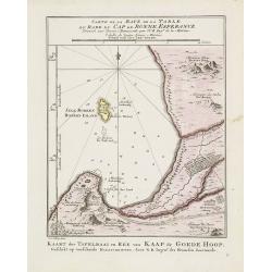
Carte de la Baye de la Table .. / Cap de Bonne Esperance.
A very nice map of the Cape of Good Hope.From Atlas Portatif pour servir a l'intelligence de l'Histoire Philosophique et Politique des etablissements et du commerce des E...
Date: Amsterdam, 1749
Selling price: ????
Please login to see price!
Sold in 2011
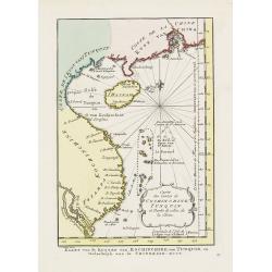
Carte des Costes de Cochinchine Tunquin.
Shows today's Vietnam, southern China and Hainan Island in the Gulf of Tonkin. Attractive cartouche and fleur-de-lys.FromAtlas Portatif pour servir a l'intelligence de l'...
Date: Amsterdam, 1749
Selling price: ????
Please login to see price!
Sold in 2010
Carte des Isles Philippines Celebes et Moluques.
Uncommon issue of this map of the Philippines Islands, Borneo, Moluccas and Sulawesi.FromAtlas Portatif pour servir a l'intelligence de l'Histoire Philosophique et Politi...
Date: Amsterdam, 1749
Selling price: ????
Please login to see price!
Sold in 2009
This plan of the cities of London and Westminster and Borough of Southwark, with the contiguous buildings..
First state of this detailed and important plan of London, engraved by Isaac Basire. With a dedication to Martin Folkes.
Date: London, 1749
Selling price: ????
Please login to see price!
Sold
Partie Sept.le des Etats de Castille où se trouvent les Roy.mes des Asturies.. Biscaye.
Small detailed map of Northwestern Spain, including Asturias, León, Old Castille, New Castille and Biscaya. Extends southwards as far as Madrid.From Atlas Portatif Unive...
Date: Paris, later than 1749
Selling price: ????
Please login to see price!
Sold in 2023
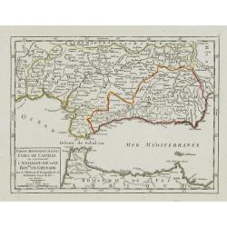
Partie Meridionale des Etats de Castille où se trouvent l'Andalousie et le Roy.me de Grenade.
Small detailed map of Andalusia. From Atlas Portatif Universel, by Robert de Vaugondy.Page 47 outside border top left. Mary Sponberg Pedley does not mention a state witho...
Date: Paris, later than 1749
Selling price: ????
Please login to see price!
Sold in 2017
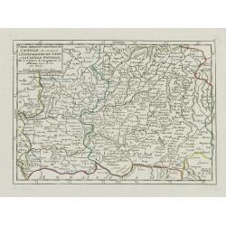
Partie Meridion.le des Etats de Castille, où se trouvent l'Estremadure-de-Leon et la Castille Nouvelle.
Small detailed map of Extremadura and New Castile. From Atlas Portatif Universel, by Robert de Vaugondy.Page 45 outside border top left. Mary Sponberg Pedley does not men...
Date: Paris, later than 1749
Selling price: ????
Please login to see price!
Sold in 2011
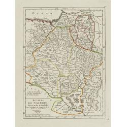
Royaume de Navarre divisé en six Mérindades.
Small detailed map of Navarre. From Atlas Portatif Universel, by Robert de Vaugondy.Page 46 outside border top right. Mary Sponberg Pedley does not mention a state withou...
Date: Paris, later than 1749
Selling price: ????
Please login to see price!
Sold in 2010
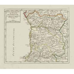
Partie Septentrionale du Royaume de Portugal.
Small detailed map encompassing the whole northern half of Portugal. From Atlas Portatif Universel, by Robert de Vaugondy.Page 50 outside border top right. Mary Sponberg ...
Date: Paris, later than 1749
Selling price: ????
Please login to see price!
Sold in 2012
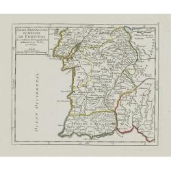
Partie Meridionale du Royaume de Portugal.
Small detailed map encompassing the whole southern half of Portugal. From Atlas Portatif Universel, by Robert de Vaugondy.Page 51 outside border top right. Mary Sponberg ...
Date: Paris, later than 1749
Selling price: ????
Please login to see price!
Sold in 2012