Browse Listings
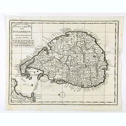
Isola Ceilon.
Attractive copper engraved map of Sri Lanka showing mountains, Towns and the Rama's Bridge (Ponte di Adamo). Included in "Atlante Novissimo che Contiene Tutte le Par...
Date: Venice, 1740
Selling price: ????
Please login to see price!
Sold in 2020
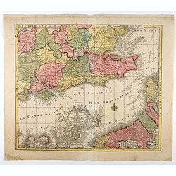
La plus grande partie de la Manche, qui contient les Côtes d'Angleterre...
Map of the English Channel. With a large decorative vignette cartouche which includes Neptune and his sea horses, Apollo, a sailing ship, and other allegorical figures.T....
Date: Augsburg, 1740
Selling price: ????
Please login to see price!
Sold in 2021
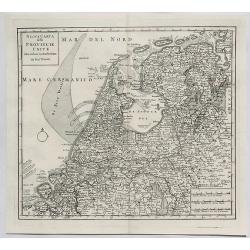
Nuova Carta delle Provincie Unite. . .
A fine map of The Netherlands and Belgium by Tirion from his "Atlante Novissimo Che Contiene Tutte Le Parti Del Mondo...." This atlas was published in Venice an...
Date: Amsterdam, 1740
Selling price: ????
Please login to see price!
Sold in 2023
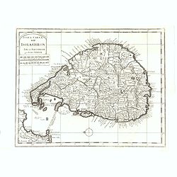
Isola Ceilon.
Attractive copper engraved map of Sri Lanka showing mountains, towns and the Rama's Bridge (Ponte di Adamo). Published by Giovanni Battista Albrizzi (1698 - 1777) and cop...
Date: Venice, 1740
Selling price: ????
Please login to see price!
Sold in 2020
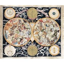
Planisphaerium Caeleste. . .
A very decorative, large double hemisphere celestial chart, centered on the North and South Poles. With circular diagrams illustrating the theories of Tycho, Ptolemy and ...
Date: Augsberg, 1740
Selling price: ????
Please login to see price!
Sold in 2020
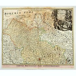
Marchionatus Moraviae circulus brunnensis. . .
Johann Baptist Homann's well-engraved map has a large decorative cartouche. Detailed map centered on Bruenn in Moravia. Prepared by Johann Chr. Mueller. Very decorative t...
Date: Nuremberg, 1740
Selling price: ????
Please login to see price!
Sold in 2020
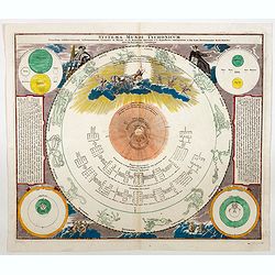
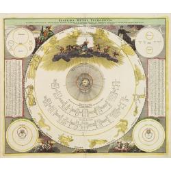
Systema Mundi Tychonicum.
A superbly decorative chart from the important Atlas Coelestis of Johann Gabriel Doppelmayr.The map represents the Tychonic system of the World, that Tycho Brahe introduc...
Date: Nuremberg, 1740
Selling price: ????
Please login to see price!
Sold in 2021
![[Lot of 4 maps] Magni Mogolis Imperium. de novo Correctum et Divisum.](/uploads/cache/85476-250x250.jpg)
[Lot of 4 maps] Magni Mogolis Imperium. de novo Correctum et Divisum.
An attractive map depicting the northern part of India, Afghanistan, Pakistan, Bangladesj, Nepal and Tibet. Embellished with a title-cartouche and a cartouche with scales...
Date: Amsterdam, ca 1740
Selling price: ????
Please login to see price!
Sold in 2022
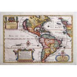
L'Amerique, Meridionale et Septentrionale. Dressee selon les dernieres relations et suivant les nouvelles decouvertes dont les points principaux sont placez sur les observations de Mrs. de l'Academie Royale des Sciences. . .
A rare later issue of this map of the Americas, with decorative cartouches for the title, dedication and scale. Engraved by Inselin for the 'Atlas Curieux', California is...
Date: Paris, 1740
Selling price: ????
Please login to see price!
Sold in 2021
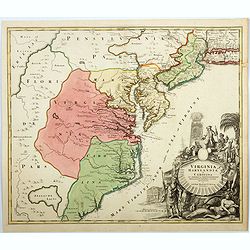
Virginia Marylandia et Carolina. . .
An very attractive and detailed map, covering the coastline from Long Island in the north to just south of Cape Feare in Carolina, with the large fictitious Apalache Lacu...
Date: Augsburg, 1740
Selling price: ????
Please login to see price!
Sold in 2023
![[Lot of 10 maps] In Notitiam Eclesiasticam Africae Tabula Geogrphica.](/uploads/cache/19552-250x250.jpg)
[Lot of 10 maps] In Notitiam Eclesiasticam Africae Tabula Geogrphica.
Very decorative copper engraved map of the northern coast of Africa, Spain, Italy and the western part of the Mediterranean with the islands of Sardinia, Corsica, Major...
Date: Paris, c. 1740
Selling price: ????
Please login to see price!
Sold in 2022
![[ Lot of 2 maps of the Asian continent]Asia Divisa in Imperia, Regna & Status in que distribuitur, ad usum serenissimi Burgundiae Ducis](/uploads/cache/86164-250x250.jpg)
[ Lot of 2 maps of the Asian continent]Asia Divisa in Imperia, Regna & Status in que distribuitur, ad usum serenissimi Burgundiae Ducis
Fine map of the Asian continent published in Amsterdam by R. and J. Ottens, after H. Jaillot.Together with a map by Claude Buy de Mornas (d. 1783), géographe du Roi (176...
Date: Amsterdam, 1740
Selling price: ????
Please login to see price!
Sold in 2025
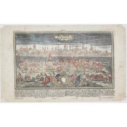
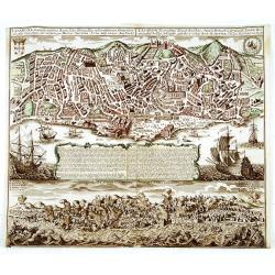
Constantinopolis. Konstantinopel.
Rare and decorative city view of Constantinople, Istanbul, Turkey. Engraved by Alexander Glaser after F.B. Werner by J.G. Ringlin drawing, published in “Europäische St...
Date: Augsburg, ca. 1740
Selling price: ????
Please login to see price!
Sold in 2023
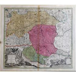
Stiria Ducatus
A fine map of Stiria /Austria includes Graz, Wiener Neustadt (Vienna Newtown), down to Croatia.
Date: Augusburg, ca 1740
Selling price: ????
Please login to see price!
Sold in 2023
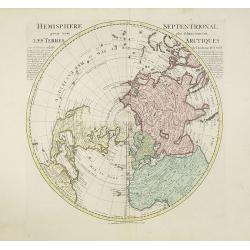
Hemisphere septentrional pour voir plus distinctement les terres arctiques. . .
Showing the Northern Hemisphere with North America, the Arctic, the Pacific, Asia and Europe after the cartographic source by the French map maker Guillaume De Isle. The ...
Date: Amsterdam, c. 1740
Selling price: ????
Please login to see price!
Sold in 2023

Nuova carta dell' Imperio della Chia e dei Paesi circonvicini. / Nueva carta de l'Impario de la Quina.
The map is of interest for the use of Mar di Corea" and "Mar Setentrionale del Giapone" in the sea between Korea and Japan.Rare early edition of Albrizzi's...
Date: Venice, 1740
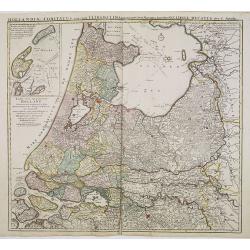
Uitrecht
Detailed map of the province of Utrecht. Including Amsterdam, Naarden, Amersfoort, Rhenen and Gouda. Fine title cartouche of Bishop and agricultural scenes.
Date: Amsterdam 1740
Selling price: ????
Please login to see price!
Sold
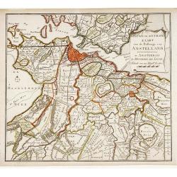
Nieuwe en Accurate Kaart van de Balluage van Amstelland.
Detailed map of the area south east of Amsterdam, including river Vecht and Muiden, Weesp, Loenen and Mijdrecht.
Date: Amsterdam 1740
Selling price: ????
Please login to see price!
Sold
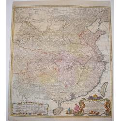
Regni Sinae vel Sinae Propriae Mappa et Descriptio Geographica ..
A highly detailed, excellent map of China based on the works of Du Halde and D'Anville. The map extends from the Gobi desert in the north to Hainan island in the south an...
Date: Nuremberg, ca 1740
Selling price: ????
Please login to see price!
Sold
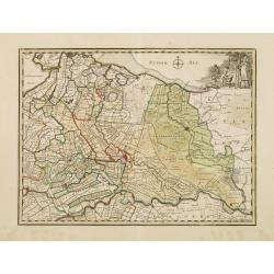
Hollandiae comitatus una cum Ultrajectino Dominio nec non maximis partibus Geldriae Ducatus / per C. Specht. . .
Scarce map of the center of the Low Countries, with the provinces North and South Holland in full contemporary body colors, with inset map of Texel and Vlieland in upper ...
Date: Amsterdam, 1740
Selling price: ????
Please login to see price!
Sold in 2020
Lisabona magnisicentissima..Portugalliae..
A most decorative bird's-eye view of Lisbon.
Date: Augsburg 1740
Selling price: ????
Please login to see price!
Sold
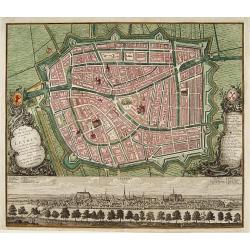
Plan dela Ville Academique et marchande de Leyden en Hollande..
Rare bird's-eye view of the town. At bottom detailed panoramic view with key.
Date: Augsburg 1740
Selling price: ????
Please login to see price!
Sold
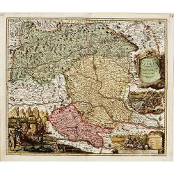
Ducatus Stiriae novissima Tabula.
"Showing Stiria in Austria, centered on Grütz, with to the right an inset with a bids-eye view of the town. Lower left and right splendid cartouches The car...
Date: Nurenberg 1740
Selling price: ????
Please login to see price!
Sold
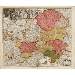
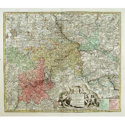
Leopolda Magni.. Germaniae Austriacae generalum..
Fine map of Austria and adjacting countries.Johann Baptist Homann born in Kammlach (1663). He was engraver, map-seller and geographer to the Kaiser of the Holy Roman Empi...
Date: Nurenberg 1740
Selling price: ????
Please login to see price!
Sold
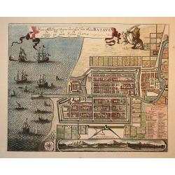
Waere Affbeeldinge Wegens het Casteel ende Stadt Batavia Gelegen opt Groot Eylant Java.
Batavia (Jakarta), the Dutch capital in the East Indies, is an exquisite and detailed plan. The plan is based on Clement de Jonghe's map of 1650, except for a modificatio...
Date: Amsterdam, 1740
Selling price: ????
Please login to see price!
Sold in 2010
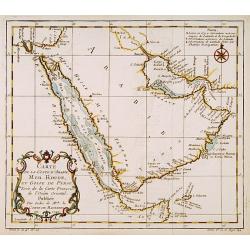
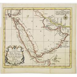
Carte de la coste d'Arabie Mer Rouge et Golfe de Perse.
With typical Rococo cartouche lower left. One of the few maps covering the Arabian Peninsular. Many coastal names appear.
Date: Paris 1740
Selling price: ????
Please login to see price!
Sold
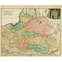
Estats de Pologne subdivises suivants les..
Decorative and detailed map of Poland, with tip of the Black Sea lower right. Prepared by Sanson, but published in Amsterdam by Petrus Schenk.
Date: Amsterdam 1740
Selling price: ????
Please login to see price!
Sold
Trevirensis Archi-Episcopatus et Electoratus
Map of the south-west part of Germany with one decorative figure cartouche.
Date: Augsburg 1740
Selling price: ????
Please login to see price!
Sold
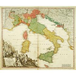
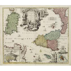
Statuum totius Italiae.. Siciliae Sardiniae..
Johann Baptist Homann's well-engraved map of Italy, Sardinia, Corsica, Malta and Sicily has a large decorative cartouche with portrait of Pope Clemens XI..Johann Baptist ...
Date: Nuremberg 1740
Selling price: ????
Please login to see price!
Sold
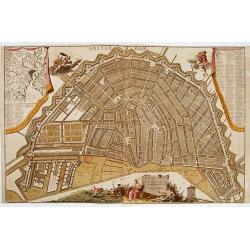
Plan tres exact de la fameuse ville marchande d'Amsterdam..
Uncommon large scale plan of Amsterdam, with a key (A-X, 1-93) in upper right corner. and a key (94-139) and a map of the region of Amsterdam in upper left corner. In the...
Date: Amsterdam 1740
Selling price: ????
Please login to see price!
Sold

Het Beloofde Landt Canaan door wandelt van onsen Salichmaecker Iesu Christo, neffens syne Apostelen
Dutch so-called Staten bibles, published between 1637 and c. 1760, contained 5 maps: The World, 'Paradise', The Perigrinations, The Promised Land Canaan, The Travels of S...
Date: Amsterdam, c. 1740
Selling price: ????
Please login to see price!
Sold
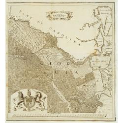
A map of the County of Savannah.
Rare map, published in the 1730s and 1740s in Halle, Germany by Samuel Urlsperger in his Ausfuhrliche Nachricht von den Saltzburgischen Emigranten..Why the map is entitle...
Date: Halle 1730- 1740
Selling price: ????
Please login to see price!
Sold
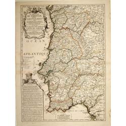
Le Royaume de Portugal divisé en cinq grandes provinces. . .
RARE map of Portugal. A visually stunning map with a large title cartouche. A second text box with a geographical description of Portugal, with the coat of arms.Nolin mus...
Date: Paris, 1740
Selling price: ????
Please login to see price!
Sold in 2023
![[Title page] Atlas Novus..](/uploads/cache/17002-250x250.jpg)
[Title page] Atlas Novus..
A very large title page featuring the people holding maps and a Queen sitting on a globe depicting Africa, Asia and Europe.
Date: Augsburg, ca. 1740
Selling price: ????
Please login to see price!
Sold
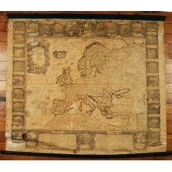
L'Europe dressé sur les nouvelles..
Separataly published: very scarce. A decorative wall map embellished by 30 panel vignettes illustrating episodes in the history of Europe. Many of the vignettes have exce...
Date: Paris 1740
Selling price: ????
Please login to see price!
Sold
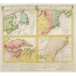
Dominia Anglorum in America Septentrionali/ Sie Gros-Brittanische Colonie Lænder in Nord-America. . .
Four maps on one sheet (Virginia und Maryland; Carolina nebsteinem Theil von Florida; New Engelland, New York, New Yersey und Pensilvania; and New Foundland, od. Terra No...
Date: Nuremberg, 1740
Selling price: ????
Please login to see price!
Sold in 2015
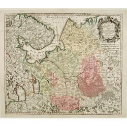
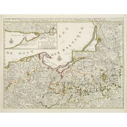
Mappae Imperii Moscovitici pars Septentrionalis..
Detailed map of northern Russia embellished with an uncolored pictorial cartouche showing hunting scenes.Prepared by de l'Isle.
Date: Augsburg 1740
Selling price: ????
Please login to see price!
Sold
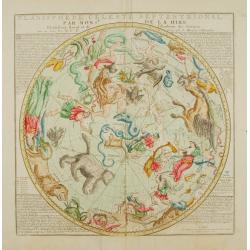
Planisphere celeste Septentrional..
Beautiful celestial chart of the northern skies by the well-known French astronomer, Philippe de La Hire. Surrounded by panels of astronomical notes at each corner. Engra...
Date: Paris 1740
Selling price: ????
Please login to see price!
Sold
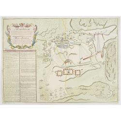
Plan der Bataille bey Stovutschane in der Moldau ..
Rare plan of a siege between the Russian army and the German and Turkish armies. Texts in German and Russian.
Date: Germany 1740
Selling price: ????
Please login to see price!
Sold
![[Attractive Manuscript Plan of the Village of Prusy (Prauss), Strzelin (Strehlen) County, near Wrocław (Breslau)]](/uploads/cache/35784-250x250.jpg)
[Attractive Manuscript Plan of the Village of Prusy (Prauss), Strzelin (Strehlen) County, near Wrocław (Breslau)]
Attractive manuscript map of the village of Prusy (Prauss), Strzelin (Strehlen) County, near Wrocław (Breslau) and coat of arms of Graf Zierotin - Freiherr von L...
Date: c.1740
Selling price: ????
Please login to see price!
Sold in 2015
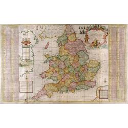
The South Part of Great Britain called England and Wales...
Full Title: The South Part of Great Britain called England and Wales. Containing all the Cities, Market Towns, Boroughs and whatever Places have the Election of Members o...
Date: London, c. 1740
Selling price: ????
Please login to see price!
Sold
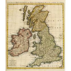
Les Isles Britanniques par Mr. De L'Isle. Geographe du Roy &c.
Uncommon map of the British Isles.
Date: Paris, c.1740
Selling price: ????
Please login to see price!
Sold
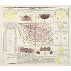
Theoria Eclipsium.
One of a series of celestial maps drawn by Johann Gabriel Doppelmayr, engraved by Homann and published in the Atlas Coelistis by Homann's Heirs.Doppelmayr was an astronom...
Date: Nuremberg 1740
Selling price: ????
Please login to see price!
Sold
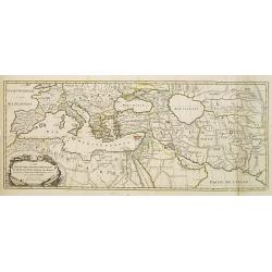
Carte Des Quatre Grandes Monarchies, des Assirieens, des Perse, des Grecs, et des Romains.. Celle Flavius Joseph .
Map covering the entire Mediterranean Basin and the Middle East as far as the borders of India. Outline coloring shows the political division.
Date: Amsterdam 1740
Selling price: ????
Please login to see price!
Sold
Basis Geographiae recentioris astronomica..
Baroque period world map in double hemispheres showing the shapes of land masses exactly calculated from astronomical observations. Roundel vignettes show cherubs making ...
Date: Nuremberg 1740
Selling price: ????
Please login to see price!
Sold
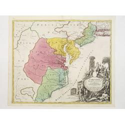
Virginia Marylandia et Carolina.
An attractive and detailed map, covering the coastline from Long Island in the north to just south of Cape Feare in Carolina, with the large fictitious Apalache Lacus in ...
Date: Augsburg 1740
Selling price: ????
Please login to see price!
Sold
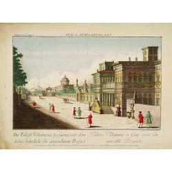
GENUA - Pallais Villamena a Gene avec son agreable Prospecte.
A well-known publisher of optical prints, established in Augsburg. In the eighteenth and nineteenth centuries there were many popular speciality establishments in Paris, ...
Date: Augsburg, 1740
Selling price: ????
Please login to see price!
Sold in 2014
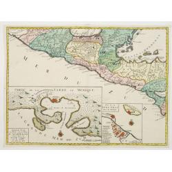
Central America, with inset maps of Acapulco and Vera-Cruz.
RARE map of Mexico and Guatemala, with insets of Acapulco and Veracruz. One sheet from a set of six offered by the Ottens firm in 1739 or shortly thereafter and relate to...
Date: Amsterdam, 1740
Selling price: ????
Please login to see price!
Sold in 2021
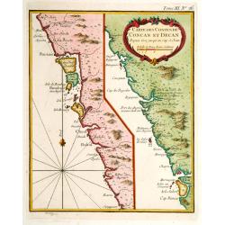
Carte des Costes de Concan et Decan..
Fine map in two parts of the west coast of India. One sheet including Bombay the other part Goa. From Petit Atlas Maritime .Jacques Nicolaas Bellin (1703-1772) was one of...
Date: Paris 1740
Selling price: ????
Please login to see price!
Sold
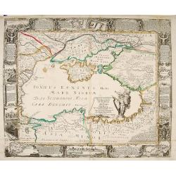
Nova et accurata Tartariae Europae.. Crimeae..
Very rare carte-a-figure map of the Black Sea area. With decorative title cartouche and surrounded by four borders with 10 city views each accompanied by large descriptiv...
Date: Augsburg 1740
Selling price: ????
Please login to see price!
Sold
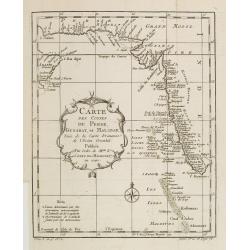
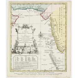
Carte des Costes de Perse, Gusarat et Malabar..
A good engraved map of the Indian Ocean, with the west coast of India, Persia, Maldives and the eastern tip of Arabia. The geographical features are typical with somewhat...
Date: Paris, 1740
Selling price: ????
Please login to see price!
Sold in 2012
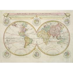
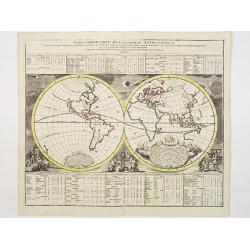
Mappe-Monde ou Description du Globe Terrestre. . .
Very rare large world map in double hemisphere. The map surround is filled with a large number of hemispheres, including one polar hemisphere. Showing the tracks of Magel...
Date: Amsterdam, 1740
Selling price: ????
Please login to see price!
Sold in 2017
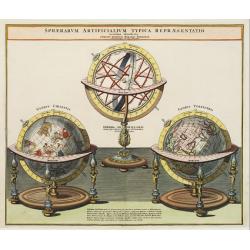
Sphaerarum Artificialium Typica Repraesentatio..
Johann Baptist Homann born in Kammlach (1663). He was engraver, map-seller and geographer to the Kaiser of the Holy Roman Empire (1715). He also was member of the Prussia...
Date: Nuremberg 1740
Selling price: ????
Please login to see price!
Sold
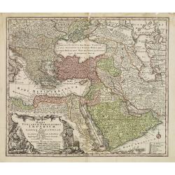
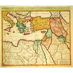
Magni Turcarum Dominatoris Imperium per Europam ..
Alluring map of the Near and Middle East centred on Turkey, giving good detail in the Arabian Peninsula.With large cartouche in lower left depicting figures with turbants...
Date: Augsburg 1740
Selling price: ????
Please login to see price!
Sold
Systema Mundi Tychonicum.
Decorative chart from the important Atlas Coelestis of Johann Gabriel Doppelmayer.The map represents the Tychonic system of the World, that Tycho Brahe introduced in 1577...
Date: Nuremberg 1740
Selling price: ????
Please login to see price!
Sold
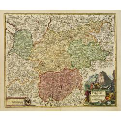
Comitatus Principalis Tirolis..
Very fine and detailed map of Tyrol, covering the towns of Kuffstein, Innsbruck, western part of Boden See, and as far south as tip of Lake Garda with the Italian area Tr...
Date: Nuremberg 1740
Selling price: ????
Please login to see price!
Sold in 2009
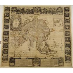
(Wall map) L'Asie Dressée sur les Nouvelles Observations..
A rare Nolin wall map of the continent of Asia, composed from four joined sheets surrounded by text and vignettes printed on separate sheets.Published in Paris and dated ...
Date: Paris 1740
Selling price: ????
Please login to see price!
Sold
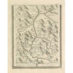
Carte du Canton de Glaris.
From Delice de la Suisse . Including Wallen See.
Date: Austria 1740
Selling price: ????
Please login to see price!
Sold
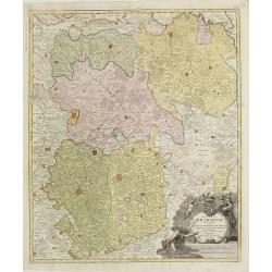
BRABANT
The Homann-family became the most important editors of atlases in Germany during the 18th. century. This map of Brabant shows the quarters: Louvain, Brussels, Antwerp, s...
Date: Nurnberg ca.1740
Selling price: ????
Please login to see price!
Sold

Samuel Pufendorf.
A portrait of Samuel Baron of Pufendorf, author of Suecia Regis.
Date: Amsterdam, 1740
Selling price: ????
Please login to see price!
Sold in 2009
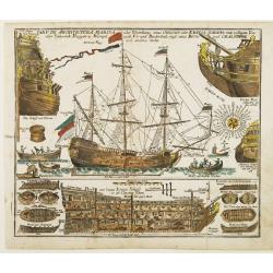
TAB.V. De Architectura Marina..
Decorative print with depiction's of the ship equipment, several ship types and their construction, rigging and further naval formation.
Date: Augsburg 1740
Selling price: ????
Please login to see price!
Sold
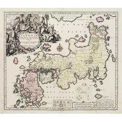
Regni Japoniae Nova Mappa Geographica..
The map is based on Englebert Kaempfer's map of 1727. It shows a much distorted outline for the Island of Japan and a wonderful decorative cartouche top left. The map was...
Date: Augsburg 1740
Selling price: ????
Please login to see price!
Sold
Regnorum Siciliae et Sardiniae.. Melitae seu Maltae ..
Johann Baptist Homann's well-engraved map of Sicily, Sardinia and Malta has a large decorative title cartouche.With ships in the sea and an inset of Valetta in lower righ...
Date: Nuremberg 1740
Selling price: ????
Please login to see price!
Sold
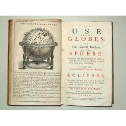
The Use of the Globes or The General Doctrine of the Sphere. To which is added a Synopsis of the Doctrine of Eclipses.
8vo, iv, 162, (2) p., old calf (slightly worn). With engr.front. and 29 fold. maps and plates.Plates includes advertisement of Senex' terrestrial and celestial globes, wo...
Date: London, J.Senex, 1740
Selling price: ????
Please login to see price!
Sold
Byzondere Kaart van de Landen daar de Apostelen het Evangelium Gepredikt hebben?en van de weg van Paulus naar Rome.
A map of the eastern Mediterranean. With the track of St. Paul\'s voyage from Cesaere to Rome. From \' Hisoire du Vieux et du Nouveau Testament\', published by Johannes C...
Date: Amsterdam, c. 1740
Selling price: ????
Please login to see price!
Sold
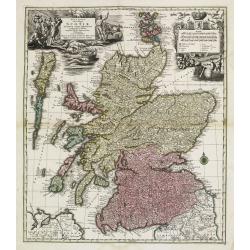
Nova et accurata totius Regni Scotiae, Secundum Omnes Provincias et adjacentes Insulas..
Fully and strongly engraved copper plate map that includes all of Scotland and the New Hebrides, here called the Western Iles of Scotland. The map is filled with minute d...
Date: Augsburg 1740
Selling price: ????
Please login to see price!
Sold
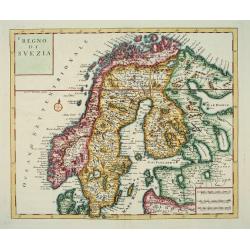
Nuova Carta del Regno di Svezia...
An attractive map of Scandinavia.Albrizzi was the first publisher to issue Tirion's maps: Tirion's own atlas was issued in Amsterdam in 1744.
Date: Venice, Albrizzi, 1740
Selling price: ????
Please login to see price!
Sold
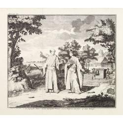
A Japanese couple.
A fine copperplate view of a Japanese couple in rather stylized dress.
Date: Amsterdam 1740
Selling price: ????
Please login to see price!
Sold
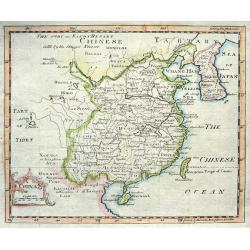
China.
Nice copper engraved map of China including Korea and Formosa (Taiwan) with much topographical detail. With an attractive title cartouche bearing also a distance scale.
Date: London, c1740
Selling price: ????
Please login to see price!
Sold
Carte des Costes de Perse Guzarat et Malabar.
Uncommon edition of this accurate map showing the east coast of India, the Maldives Islands and the eastern tip of Arabia. In lower left corner a lettered key.FromAtlas P...
Date: Amsterdam, 1740
Selling price: ????
Please login to see price!
Sold in 2014
Regni Borussiae.. Royaume de Prusse..
Rare map of Prussia, with inset map of the area around Koningsberg.RARE.
Date: Amsterdam, 1740
Selling price: ????
Please login to see price!
Sold
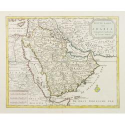
Nieuwe kaart van Arabia.
An attractive map of the Arabian Peninsula here called Gelukkig Arabia or Happy Arabia . The map has a great advance on other maps of the time by showing the true extent ...
Date: Amsterdam, 1740
Selling price: ????
Please login to see price!
Sold
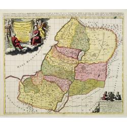
Iudae seu Terra Sancta quae Hebraeorum sive Israelitarum..
A dark impression with decorative cartouches.
Date: Amsterdam, 1740
Selling price: ????
Please login to see price!
Sold in 2009
Carte de la coste d'Arabie Mer Rouge et Golfe de Perse.
With typical Rococo cartouche lower left.
Date: Paris, 1740
Selling price: ????
Please login to see price!
Sold in 2021
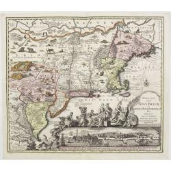
Recens edita totius Novi Belgii in America Septentrionali.
This most spectacular map, the last engraved in the sequence of maps based on the Janssonius' map of the area, shows a multitude of animals and birds and features a view ...
Date: Augsburg, ca. 1730-1740
Selling price: ????
Please login to see price!
Sold
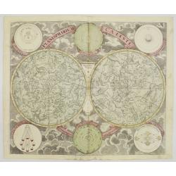
Planisphaerium Caeleste.
A very decorative double hemisphere celestial chart, centered on the North and South Poles.With smaller circular diagrams illustrating the theories of Tycho, Ptolemy and ...
Date: Augsburg, 1740
Selling price: ????
Please login to see price!
Sold
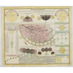
Theoria Eclipsium.
One of a series of celestial maps drawn by Johann Gabriel Doppelmayr, engraved by Homann and published in the Atlas Coelistis by Homann's Heirs.Doppelmayr was an astronom...
Date: Nuremberg, 1740
Selling price: ????
Please login to see price!
Sold
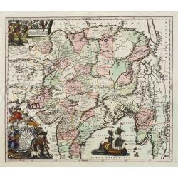
Imperii Magni Mogolis sive Indici Padschach..
Impressive map of the Mongol Empire, including present India (except the southern tip), Pakistan, Afghanistan, parts of Burma, etc.Decorated with two colored pictorial ca...
Date: Augsburg, ca 1740
Selling price: ????
Please login to see price!
Sold
![[Five maps on one sheet] Dominia Anglorum in praecipuis Insulis Americae ut sunt Insula S. Christopheri, Antegoa, Iamaica, Barbados nec non Insula Bermudes vel Sommers . . .](/uploads/cache/25265-250x250.jpg)
[Five maps on one sheet] Dominia Anglorum in praecipuis Insulis Americae ut sunt Insula S. Christopheri, Antegoa, Iamaica, Barbados nec non Insula Bermudes vel Sommers . . .
Interesting set of 5 maps on a single sheet, showing Jamaica, Bermuda, Antigua, Barbados and St. Kitts. With a large decorative title cartouche. Each map is very detailed...
Date: Nuremberg, 1740
Selling price: ????
Please login to see price!
Sold in 2008
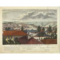
Vuë de ters=hana et Kassim=pacha, fauxbourgs de Constantinople et de leurs Environs situés à l'Orient de la Ville principale.
This rare print is the 9th sheet from an uncommon set forming a panoramic of Istanbul. Engraved by I.G.Thelot and published at the l'Academie Imperiale in Augsburg. The ...
Date: Augsburg, 1740
Selling price: ????
Please login to see price!
Sold in 2008