Browse Listings
(Chambery, Mon Melian, Grenoble, etc.)
Rare miniature map including the towns of Chambery, Mon Melian, Grenoble, etc. From "Le theatre De Bellone, Contenant 48. nouvelles Cartes Geographiques, Des Païs-B...
Date: Amsterdam, 1710
Selling price: ????
Please login to see price!
Sold in 2018
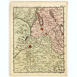
(Lake Maggiore, Arona, Novara, Monferrato, Valence, etc.)
Rare miniature map including Lake Maggiore and the towns of Arona, Novara, Monferrato, Valence, etc. From "Le theatre De Bellone, Contenant 48. nouvelles Cartes Geog...
Date: Amsterdam, 1710
Selling price: ????
Please login to see price!
Sold in 2016
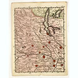
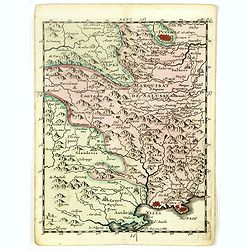
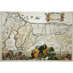
(Brinaçon, Susa, Turin, etc.)
Rare miniature map including the towns of Brinaçon, Susa, Turin, etc. From "Le theatre De Bellone, Contenant 48. nouvelles Cartes Geographiques, Des Païs-Bas Espag...
Date: Amsterdam, 1710
Selling price: ????
Please login to see price!
Sold in 2019
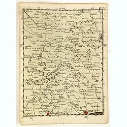
(Les Sevennes, Montpellier, Pezenas, etc.)
Rare miniature map including the towns of Les Sevennes, Montpellier, Pezenas, etc. From "Le theatre De Bellone, Contenant 48. nouvelles Cartes Geographiques, Des Pa�...
Date: Amsterdam, 1710
Selling price: ????
Please login to see price!
Sold in 2020
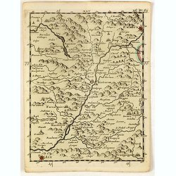
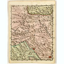
(Embrun, Gap, Sisteron, etc.)
Rare miniature map including the towns of Embrun, Gap, Sisteron, etc. From "Le theatre De Bellone, Contenant 48. nouvelles Cartes Geographiques, Des Païs-Bas Espagn...
Date: Amsterdam, 1710
Selling price: ????
Please login to see price!
Sold in 2020
(Pinerolo, Brueil, Antibe, Monaco, etc.)
Rare miniature map including the towns of Pinerolo, Brueil, Antibe, Monaco, etc. From "Le theatre De Bellone, Contenant 48. nouvelles Cartes Geographiques, Des Païs...
Date: Amsterdam, 1710
Selling price: ????
Please login to see price!
Sold in 2020
The South Part of Great Britain, Called, England and Wales. Containing All ye Cities, Market Towns, Boroughs: And whatever Places have ye Election of Members of Parliament
A large and finely detailed, copper engraved map featuring hundreds of villages, towns, mountains and much more. In the title, the "South Part" of Great Britain...
Date: London, 1710
Selling price: ????
Please login to see price!
Sold in 2016

(La Duché de Bourgogne, Troyes, Dion, etc.)
Rare miniature map of La Duché de Bourgogne, including the towns of Troyes, Dion, etc. From "Le theatre De Bellone, Contenant 48. nouvelles Cartes Geographiques, De...
Date: Amsterdam, 1710
Selling price: ????
Please login to see price!
Sold in 2017
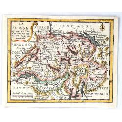
La Suisse Divisee en XIII Cantons en Ses Alliez et Sujets par Inselin
A fine little map of Switzerland and its thirteen Cantons. Features a simple cartouche and a compass rose. Engraved by Inselin.Charles Inselin (Inslain), was a French eng...
Date: Paris, ca 1710
Selling price: ????
Please login to see price!
Sold in 2017
Novi Orbis sive Totius Americae cum adiacentibus Insulis. . .
A nice map of the Americas, supplemented by a splendidly decorative title cartouche in the lower left corner of the map. It features native Indians and a Westerner smokin...
Date: Nuremberg, 1710
Selling price: ????
Please login to see price!
Sold in 2017
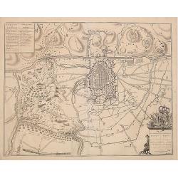
Plan de la Bataille D'Oudenaerde.
A plan of the Battle of Oudenaerde fought on July 11th 1708. A finely engraved plan with excellent detail of the fortifications of Oudenaerde in Belgium. With a decorativ...
Date: Amsterdam, 1710
Selling price: ????
Please login to see price!
Sold in 2018
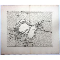
Plan de la Ville et Citadelle D'Arras.
A detailed plan of the town and citadelle of Arras. Arras is the capital of the Pas-de-Calais department of France, which forms part of the region of Hauts-de-France. Ar...
Date: Amsterdam, 1710
Selling price: ????
Please login to see price!
Sold in 2020
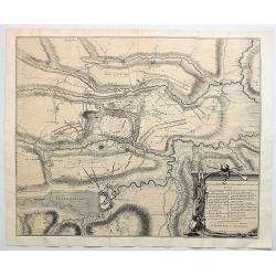
Plan de la Ville et Citadelle de Cambray.
A detailed plan of the town and Citadelle of Cambray. Cambrai, (old spelling Cambray) is a commune in the Nord department and in the Hauts-de-France region of France on ...
Date: Amsterdam, 1710
Selling price: ????
Please login to see price!
Sold in 2019
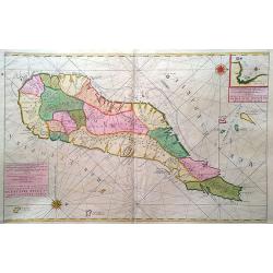
Carte particuliere de L´Isle Dauphine ou Madagascar et St Laurens.
A big, beautiful, brightly colored map of Madagascar, Comoros, I. De Bourbon, Santa Apolonia, I. Ioan de Lisboa and other islands. With an inset map of Baye St. Augustin....
Date: Amsterdam, ca. 1710
Selling price: ????
Please login to see price!
Sold in 2017
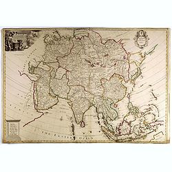
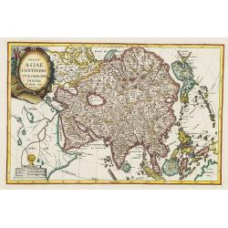
Asia Corrected from the Observations Communicated to the Royal Society at London and the Royal Academy at Paris...
Nice example of this scarce large format map of Asia by Senex. The map is most remarkable for its detail in South east Asia, the Philippines, Larrones Isles, New Guinea a...
Date: London, 1710
Selling price: ????
Please login to see price!
Sold in 2017
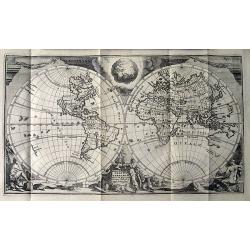
Theatrum historicum ad Annum Christi Quadringentesimum...
A striking map of the world from the time of the Roman Empire. Dating from the 8th century, the Roman empire expanded to become one of the largest empires in the ancient...
Date: Paris, 1710
Selling price: ????
Please login to see price!
Sold in 2018
Theatrum historicum ad Annum Christi Quadringentesimum...
Striking map of the world in two Hemispheres from the time of the Roman Empire. Dating from the 8th century, the Roman empire expanded to become one of the largest empi...
Date: London, 1710
Selling price: ????
Please login to see price!
Sold in 2018
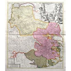
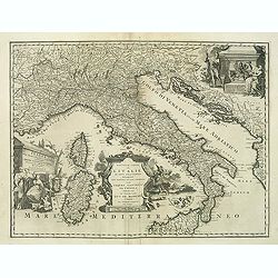
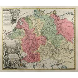
Les Estats De Savoye, Piemont, et le Comte de Nice.
An attractive folio map of northern Italy (Piemonte and Torino) and Savoie. Extends from Lake Geneva until Nice and Monaco. Large decorative cartouche with the coat of ar...
Date: Amsterdam, ca. 1710
Selling price: ????
Please login to see price!
Sold in 2018
Tabula Nova Provinciae UltraJectinae. . .
This striking map was prepared by Nicolas Visscher, now published by Petrus Schenk. It shows the land development in Gelderland, Holland, near the Zuyder Zee and it shows...
Date: Amsterdam, 1710
Selling price: ????
Please login to see price!
Sold in 2020
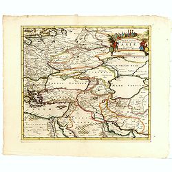
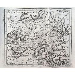
Tabula Altera Quae Continet Potissima Asiae et Reliqua Europae ac Africae.
Uncommon map covering a broad region centered on the Black and Caspian Seas. This was a region long disputed between the Christian and Islamic empires and the title carto...
Date: Amsterdam, 1710
Selling price: ????
Please login to see price!
Sold in 2019
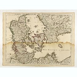
Carte du Royaume de Danemarc.
Guillaume de l'Isle's (1675-1726) well deserved reputation as one of the foremost geographers of the 18th century meant that his maps were influential for many years afte...
Date: Paris, 1710
Selling price: ????
Please login to see price!
Sold in 2022
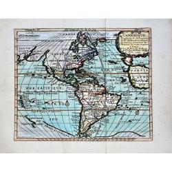
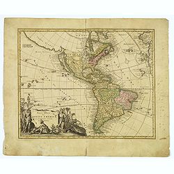
L'Amerique, Dressee sur les Observations de Mrs. de l'Academie Royale des Sciences, et suivant les Memoires les moins suspects.
A nice, scarce map depicting the American continent with the known towns, rivers and lakes. It shows the mythical 'Terre de Jesso', Tierra del Fuego is depicted as an isl...
Date: Paris, 1710
Selling price: ????
Please login to see price!
Sold in 2018
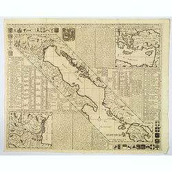
Totius Danubii Nova & Accuratiss. Tabula, Universam Simul Turciam Europaeam Hungarium Magnam Germaniae Partem...
A very rare, large map depicting Italy, Sicily, Sardinia, Corsica, Greece, part of Turkey, Hungary and part of the Balkans region. Originally from France, the family de l...
Date: Amsterdam, 1710
Selling price: ????
Please login to see price!
Sold in 2018

New Map of Ancient Gaul or Gallia Transalpina.
A fine map of Ancient France engraved by Robert Spofforth, and published by Wells for "A New Sett of Maps Both of Ancient and Present Geography". This map was d...
Date: London, 1710
Selling price: ????
Please login to see price!
Sold in 2023
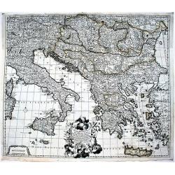
Carte de Geographie des Differents Etats de la Republique de Venise. . .
An attractive and detailed engraving of the Gulf of Venice and adjacent Italian and Dalmatian coastlines. The main map runs diagonally across the sheet with inset detail ...
Date: Amsterdam, 1710
Selling price: ????
Please login to see price!
Sold in 2019
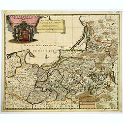
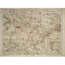
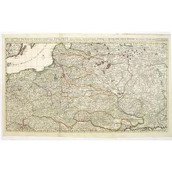
Regni Prussici Accuratissima Delineatio Studio Opera.
A striking map of Prussia covering Danzig, (Poland) Marienburg, Elbing, Braunsberg, Konigsberg (Russia) and up into modern-day Lithuania and Memel. The map has a remarkab...
Date: Amsterdam, ca 1710
Selling price: ????
Please login to see price!
Sold in 2019
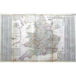
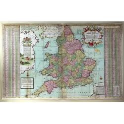
The South Part of Great Britain, called Engalnd and Wales.
Herman's Moll's magnificently detailed large scale map of England and Wales. Including a part of Ireland. Filled with cities, roads showing the distances between towns, r...
Date: London, ca 1710
Selling price: ????
Please login to see price!
Sold in 2019
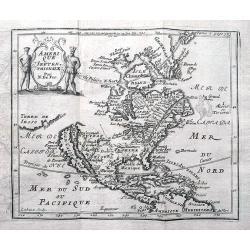
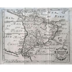
Amerique Septentrionale.
Early and interesting map of North America with large blank parts and California as an island. Names a large Floride. Rey Coromedo Nouveau in todays Arizona, and Coste de...
Date: Paris, ca. 1710
Selling price: ????
Please login to see price!
Sold in 2019
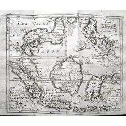
Les Isles Philippines, Molucques et de la Sonde.
Detailed map of the Philippines, Borneo and Indonesia. With an inset map of Japan. Names Singapore (Sincapura) and extends until Timor. The equator line is shown.
Date: Paris, ca. 1710
Selling price: ????
Please login to see price!
Sold in 2019
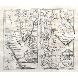
Presqu'isle de l'Inde decale Golfe du Gange. & Presqu'isle de l'Inde dela le Golfe du Gange.
Two early maps on one sheet, one showing souther India, the Maledives and Sri Lanka. The other shows former Pegu and Siam, todays Myanmar, Thailand, Malaysia, Cambodia, L...
Date: Paris, ca. 1710
Selling price: ????
Please login to see price!
Sold in 2019
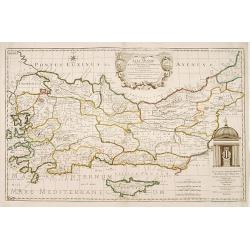
Asia Minor..
Rare map of Turkey and Cyprus, published by Pierre Moullart-Sanson, who was the grandson of Nicolas the elder.The two title cartouches are printed from different copperpl...
Date: Paris 1710
Selling price: ????
Please login to see price!
Sold
Nouvelle carte de l'Italie ou sont exactement marquez les postes et les chemins. . .
Map of Italy, with depiction of the most important post routes. To the left the islands of Corsica and Sardine. Prepared by Cantelli, Giacomo Cantelli (1643-1695). With t...
Date: Leiden, c. 1710
Selling price: ????
Please login to see price!
Sold
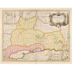
Moscovia pars Australis.
Prepared by Isaac Massa, a Dutch map-maker who travelled to Russia, returning to Holland in 1609, bringing with him a large amount of original cartographic manuscript mat...
Date: Amsterdam 1710
Selling price: ????
Please login to see price!
Sold in 2011
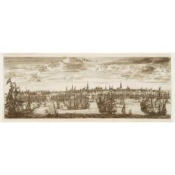
Amsterdam
A panoramic view of Amsterdam seen from 't IJ. A very decorative print with extensive shipping.From "Les Délices de la Hollande.. Ouvrage Nouveau sur le p...
Date: The Hague 1710
Selling price: ????
Please login to see price!
Sold
Plan de la Bateille de Turin..
Extremely fine and detailed plan by Huchtenburg depicting the siege of Turin (Italy) by Price Eugene on September 7th 1706.
Date: Brussels 1710
Selling price: ????
Please login to see price!
Sold
![Regnum Judeorum In Filios Herodis Magni.. [Four seasons]](/uploads/cache/14380-250x250.jpg)
Regnum Judeorum In Filios Herodis Magni.. [Four seasons]
A set of four sheets each depicting one of the seasonsSpring depicts the erection of the "may Tree". Summer shows the fires of St John.Autumn presents a rural m...
Date: Paris c.1710
Selling price: ????
Please login to see price!
Sold
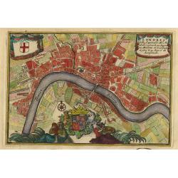
Londres.
Nice little plan of London, with 3 cartouches with coat of arms.
Date: Amsterdam 1710
Selling price: ????
Please login to see price!
Sold
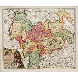
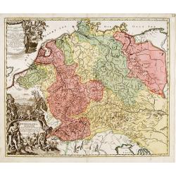
Ducatus Brunsuicensis..
"Showing the area of Hildesheim, Gottingen, Wolfenbuttel, etc. Lower left splendid title cartouche.The map is painted in strong and a somewhat impressionistic way. C...
Date: Nurenberg, 1710
Selling price: ????
Please login to see price!
Sold in 2013
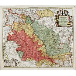
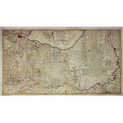
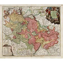
Archiepiscopatus et electoratis Coloniensis..
"Detailed map covering the area in-between Maastricht, Weert, Nijmegen, Dü'sseldorf, Cologne and Bonn. Upper right splendid title cartouche.The map is painte...
Date: Nurenberg 1710
Selling price: ????
Please login to see price!
Sold
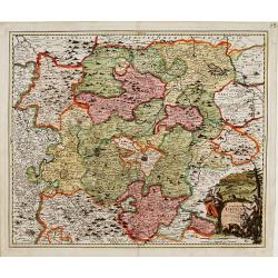
Landgraviatus Thuringae tabula generalis. . .
Detailed map centered on Gotha and Erfurt. Lower right splendid title cartouche.The map is painted in strong colors. Clearly from an show-piece atlas produced for a wealt...
Date: Nurenberg, 1710
Selling price: ????
Please login to see price!
Sold in 2018
Exactissima Palatinatus ad Rhenum..
Covering southern part of the river Rhine. Including the towns of Frankfurt, Heidelberg, Neustadt, Saarbrücken, Mainz, etc.. Upper right splendid title cartouche.The map...
Date: Nurenberg, 1710
Selling price: ????
Please login to see price!
Sold in 2018
Hydrographia Germaniae..
Showing the river system of western Europe. Upper and lower left corner splendid title cartouches with Neptune and other mythological figures.The map is painted in strong...
Date: Nurenberg 1710
Selling price: ????
Please login to see price!
Sold
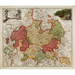
Landgraviatus Hassiae Inferioris..
"Detailed map centered on Kassel Upper left and right splendid title cartouches.The map is painted in strong colors. Clearly from an show-piece atlas produced for a ...
Date: Nurenberg 1710
Selling price: ????
Please login to see price!
Sold
Polus Arcticus.
Interesting polar projection featuring CALIFORNIA AS AN ISLAND. Three astronomical diagrams below.
Date: Munich ca. 1710
Selling price: ????
Please login to see price!
Sold
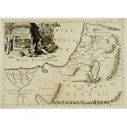
Patriarchatus Hierosolymitani Geographica descriptio.
An ecclesiastical map showing the extent of Patriarchate of Jerusalem in Roman times. Divided into Palestine prima, secunda, salvtatis. The shore line runs from Sicaminum...
Date: Amsterdam 1699-1710
Selling price: ????
Please login to see price!
Sold
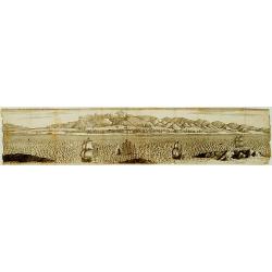
No title.
A fine and rare panoramic view of a town in the Near East. With extensive shipping on the foreground. From the Voyage de M. le Chevalier Chardin en Perse, et autres lieux...
Date: Paris,1710
Selling price: ????
Please login to see price!
Sold in 2012
![[Ruines d'un palais perse]](/uploads/cache/16328-250x250.jpg)
[Ruines d'un palais perse]
From the Voyage de M. le Chevalier Chardin en Perse, et autres lieux de l'Orient.
Date: Paris, 1710
Selling price: ????
Please login to see price!
Sold in 2014
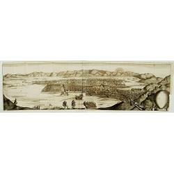
No title.
From the Voyage de M. le Chevalier Chardin en Perse, et autres lieux de l'Orient.Panoramic view of a city in the Near East.
Date: Paris, 1710
Selling price: ????
Please login to see price!
Sold in 2012
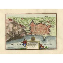
Barcelonne.
Nice little plan of Barcelona, with a nice cartouche with coat of arms.
Date: Amsterdam 1710
Selling price: ????
Please login to see price!
Sold
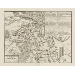
Plan de la Bataille de Malplaquet Donnée entre l'armée du Roy et celle des alliés le 11. Sept. 1709.
Extremely fine and detailed plan depicting the siege of de Malplaquet over Price Eugéne on September 11th 1709. With key list in the upper right corner. Engrav...
Date: Paris, 1710
Selling price: ????
Please login to see price!
Sold in 2009
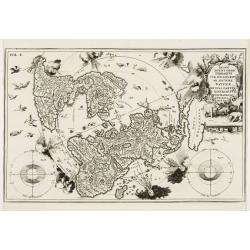
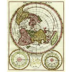
Imago Totius Orbis..
A very graphic map of the world on a north polar projection. Surrounding the lands are two astronomical round diagrams, eight classic wind heads usually seen on 16th cent...
Date: Munich ca. 1710
Selling price: ????
Please login to see price!
Sold

Les Duchés de Clèves, de Iuliers et de Limbourg..
Including Cleve, Wesel, Emmerich,
Date: Paris, ca. 1710
Selling price: ????
Please login to see price!
Sold
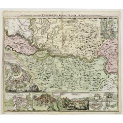
Neu Geographisch vorgestelltes Ungarisches Kriegs -Theatrum. . .
A rare map centered on Belgrade, including two plans of the battle of Belgrade and Temeswar in 1717 : underneath the map, two views of Belgrade and the Serbian city of Sm...
Date: Nuremberg, ca 1710
Selling price: ????
Please login to see price!
Sold in 2020
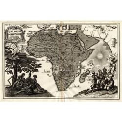
Representatio Totius Africae ...
This is Scherer's (1628-1704) famous but rather uncommon map showing the skeleton chopping down the tree. Based on his earlier map of the continent (see Norwich Map 62),...
Date: Munich 1710
Selling price: ????
Please login to see price!
Sold
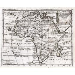
L'Afrique
Nicolas Bion (1652-1733) was a French mapmaker in Paris. In 1710 Bion's L'Usage des Globes Celestes et Terrestrees et des spheres was published, from which this map com...
Date: Paris, 1710
Selling price: ????
Please login to see price!
Sold
Werelt Caert
Beautiful double hemisphere from a Dutch Bible. Surrounded by allegorical representations of the continents, based on Visscher. CALIFORNIA AS AN ISLAND with a flat northe...
Date: Dordrecht 1710
Selling price: ????
Please login to see price!
Sold
Novi Imperii Germanici ? L'Allemagne Dressé sur les observations ..
Fine map of Germany, Low countries, Switzerland, Austria and Poland. Pierre Mortier copied the map of Nicolas Sanson and de L'Isle. Sanson was to bring about the rise of ...
Date: Amsterdam, 1710
Selling price: ????
Please login to see price!
Sold in 2008
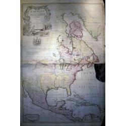
North America corrected from the observations communicated to the Royal Society of London, and the Royal Academy at Paris...
Monumental and important large wall map of the Eastern part of North America with the United States, Central America, and the West Indies. Centered on the great lakes.1st...
Date: London, c 1710
Selling price: ????
Please login to see price!
Sold in 2008
Pergrinatie ofte Veertich-iarige Reyse
Dutch Bible map of the Holy Land depicting the Exodus from Egypt and the wanderings of the Children of Israel. The lower part of the map is elaborately engraved with a sc...
Date: Amsterdam, 1710
Selling price: ????
Please login to see price!
Sold
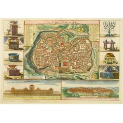
De Stadt Jerusalem.
A stunning "carte à figures" plan of ancient Jerusalem from a Dutch bible after Villalpando. Lower left the Temple as a Renaissance palace and lower right a pa...
Date: Amsterdam, 1710
Selling price: ????
Please login to see price!
Sold in 2008
Hydrographia Germaniae qua Geographiae Naturalis
colored map of the river system of Germany from J. B. Homann. With two beautiful cartouches. From "Grosser Atlas".
Date: Nuremberg, 1710
Selling price: ????
Please login to see price!
Sold in 2009
Totius Asiae continens cum praecipuis insulis eidem annexis
On this map Hokkaido is connected with Honshu and even bigger depicted than Honshu. In lower left cartouche a scale and a monstrance with the sign of the Society of Jesus...
Date: Munich, 1710
Selling price: ????
Please login to see price!
Sold in 2008
Legazione di Bologna . . .
A uncommon map of part of the Bologna region in northern Italy, in the Po Valley, between the Po River and the Apennines, exactly between the Reno River and the Sàvena R...
Date: Rome, ca. 1710
Selling price: ????
Please login to see price!
Sold in 2009
Werelt Caert. Orbis terrarum
Lovely double hemisphere map from a Dutch Bible. Title inside the surrounding allegorical representations of the continents, based on Visscher. CALIFORNIA IS AN ISLAND wi...
Date: Amsterdam 1710
Selling price: ????
Please login to see price!
Sold in 2009
![Theatre de la Guerre en Espange et en Portugal. . . Presenté à Philippe V Roy d'Espagne, et de Indes. . . [four sheets]](/uploads/cache/01579-250x250.jpg)
Theatre de la Guerre en Espange et en Portugal. . . Presenté à Philippe V Roy d'Espagne, et de Indes. . . [four sheets]
The map is exceptionally detailed, but the most remarkable feature of the engraving is the enormous, superbly detailed and designed title-piece. A dedication to Philip V ...
Date: Amsterdam, 1710
Selling price: ????
Please login to see price!
Sold in 2009
![Le Royaume de Siam avec Les Royaumes Qui Luy sont Tributaries & c. / La Royaume de Siam avec les royaumes qui luy sont Tributaires, et les Isles de Sumatra, Andemaon, etc. . . [two sheet map]](/uploads/cache/27847-250x250.jpg)
Le Royaume de Siam avec Les Royaumes Qui Luy sont Tributaries & c. / La Royaume de Siam avec les royaumes qui luy sont Tributaires, et les Isles de Sumatra, Andemaon, etc. . . [two sheet map]
Influential map of Southeast Asia and the East Indies including modern day Thailand, southern Vietnam, Cambodia, Malaysia, Singapore, Borneo, Sumatra and Java. Ottens inc...
Date: Amsterdam, 1710
Selling price: ????
Please login to see price!
Sold in 2009
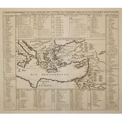
Carte Geographique de l'Asie Mineure ...
Detailed map of the Mediterranean Region, from Chatelain's monumental Atlas Historique.
Date: Paris, 1710
Selling price: ????
Please login to see price!
Sold in 2011
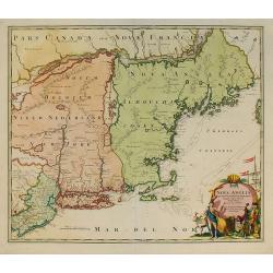
Nova Anglia Septentrionali Americae implantata ..
German interest in North America was high during the first half of the eighteenth century when Johan Baptiste Homann was the leading German cartographer. During this peri...
Date: Nuremberg, c.1710
Selling price: ????
Please login to see price!
Sold in 2011
![Creatio Universi... [Genesis]](/uploads/cache/91539-250x250.jpg)
Creatio Universi... [Genesis]
An attractive and skillful engraving of the creation of the universe, the earth surrounded by planetary orbits, by Tigur Melchior Fuesslinus who flourished as an engraver...
Date: Augsburg, c.1710
Selling price: ????
Please login to see price!
Sold in 2010
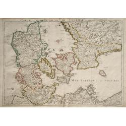
Carte du Royaume de Danemarc
Detailed map of Denmark, also including southern Sweden and northern Germany, showing the city of Copenhagen (Copenhague).
Date: Paris, 1710
Selling price: ????
Please login to see price!
Sold in 2010
Carte du Diocese de Beauvais.
Map of the Roman Catholic Diocese of Beauvais, in north central France. The town of Beauvais, the seat of the seat of the Diocese, and home to the beautiful gothic cathed...
Date: Paris, 1710
Selling price: ????
Please login to see price!
Sold in 2010
Carte marine de la mer Caspienne avec toutes ses Bayes Rivieres et Havres, dressée sur les observations des plus habiles Navigateurs,. . .
Strikingly engraved and attractive map of the region south of the Caspian Sea, showing major towns, ports, etc. Large compass rose in Arabia.
Date: Leiden, 1710
Selling price: ????
Please login to see price!
Sold in 2010
Nansenbushu bankoku shoka no zu.
This map is a great example of Japanese world maps representing Buddhist cosmology with real-world cartography. It is the earliest one and - therefore - the prototype for...
Date: Kyoto, 1710
Selling price: ????
Please login to see price!
Sold in 2010
Reipublicae et status generalis Poloniae nova Tabula comprehendens Maioris et minoris Poloniae Regni.
Large map of Poland, reaching in the east as far as the Crimea. Engraved by Jacob Keyser.Joachim Ottens (1663 - 1719) and his sons Renier and Joshua were prominent Dutch ...
Date: Amsterdam, ca. 1710
Selling price: ????
Please login to see price!
Sold in 2010
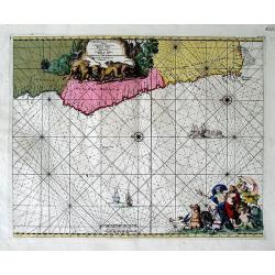
Cimebebas et Caffariae Littora a Catenbela ad Promontorium Bonae Spei. Pascaerte... Gedruckt tot Amsterdam by L Renard.
A highly decorative of the southern and southwest coast of Africa including the Cape of Good Hope. A large title cartouche dominates the top of the chart. This cartouc...
Date: Amsterdam, (c.1675) 1710
Selling price: ????
Please login to see price!
Sold in 2011
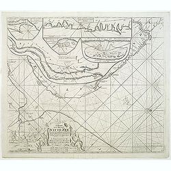
Paskaart van de Mont van de Witte Zee,. Beginnende van Tiepena tot Pelitza, als mede van C. Cindenoes tot Catsnoes.
Fine sea chart of the southern part of the Barents Sea, oriented to the West. With 5 inset maps: - Swetenoes, de Kust van Laplandt, Lombascho, ''T Vaste Landt van Lapland...
Date: Amsterdam, c.1710
Selling price: ????
Please login to see price!
Sold in 2011
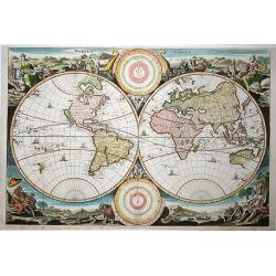
Orbis Terrarum Nova et Accuratissima Tabula.
Superb elaborate double-hemisphere copper engraved map of the world. Shows California as an island, large "Compagnies Land" between the Asian and American cont...
Date: Leiden, c. 1710
Selling price: ????
Please login to see price!
Sold in 2011
Asie.
A small map of Asia with curiously shaped coast lines. Korea is shown as being thin and long, whilst Japan is misshaped, as is India. Includes the Philippines, Borneo and...
Date: Paris, ca 1710
Selling price: ????
Please login to see price!
Sold in 2019
Amerique meridionale.
A small map of South America with an interestingly shaped of coast line. It shows a few dates and fictional islands. A large "Terres Inconnues" is shown in the ...
Date: Paris, ca 1710
Selling price: ????
Please login to see price!
Sold in 2019
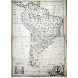
SOUTH AMERICA. Corrected from the Observations comunicated to the Royal Societys of London & Paris.
A lovely extra large map of South America, dedicated by Senex to the famous Astronomer and Mnathematician Edmund Halley LLD Savilian Professor of Geometery in Oxford and ...
Date: London, 1710
Selling price: ????
Please login to see price!
Sold in 2022