Browse Listings
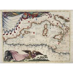
Ristretto del Mediterraneo...
Very large, extremely decorative map of the Western part of the Mediterranean Sea. It is embellished with coats of arms and decorative cartouches, Vincenzo Maria Coronell...
Date: Venice, 1690
Selling price: ????
Please login to see price!
Sold in 2023
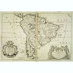
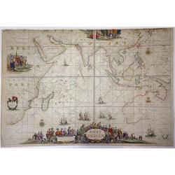
America meridionale . . .
Gorgeous example of Coronelli's famous map of South America. The outline of South America is well charted and every port and bay has been identified and named in detail. ...
Date: Venice, 1690
Selling price: ????
Please login to see price!
Sold in 2017
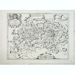
![Corso del Reno parte settentrio [tohether with] . . . parte meridionale. . . [2 sheets]](/uploads/cache/31970-250x250.jpg)
Corso del Reno parte settentrio [tohether with] . . . parte meridionale. . . [2 sheets]
A two sheet map of the course of the river Rhine. Each of the map has a decorative cartouche for title and dedication to Paulo Querini. Engraved in Coronelli's unique sty...
Date: Venice, 1690
Selling price: ????
Please login to see price!
Sold in 2012
Hunouang, e Sucuhen, Provincie della Cina. . .
A beautiful map depicting part of China with decorative title cartouche and scale cartouche. Information about the area at the top of the map.The remarkable Vincenzo Coro...
Date: Venice, 1690
Selling price: ????
Please login to see price!
Sold in 2012
Xantung, e Peking Provincie della China, divise sue Regioni . . .
A beautiful map depicting the area of Beijing with decorative title cartouche and scale cartouche. Information about the area at the top of the map.To the right the west ...
Date: Venice, 1690
Selling price: ????
Please login to see price!
Sold in 2012
Nanking, et Honan Provincie della China. . .
A beautiful map depicting part of China with Nanking (Jiangsu) and Honan (Henan), with decorative title cartouche and scale cartouche. Information about the area in the u...
Date: Venice, 1690
Selling price: ????
Please login to see price!
Sold in 2012
Xansi, e Xensi Provincie della China . . .
A beautiful map depicting part of China and showing a stretch of the Great Wall and the Deserto de Xamo. With decorative title cartouche, scale cartouche and a cartouche ...
Date: Venice, 1690
Selling price: ????
Please login to see price!
Sold in 2012
Chekiang, e Kiangsi, Provincie della Cina. . .
Impressive map of Zhejiang and Jiangxi from Coronelli's set of six maps showing thirteen Chinese provinces, is modeled on the earlier maps by Joan Blaeu and the Jesuit Ma...
Date: Venice, 1690
Selling price: ????
Please login to see price!
Sold in 2012
Hur in Caldea nu gheheeten Hurcasdijn by allepo.
Magnificent bird's eye- of the ancient city of Ur(fa) now-a-days Hurcasdin. Etched by Gaspar Bouttats (1640-1695).The Antwerp based publisher Jacques Peeters published ca...
Date: Antwerp, c.1690
Selling price: ????
Please login to see price!
Sold in 2016
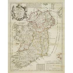
Le Royaume d'Irlande ...
Uncommon map of Ireland. A visually stunning map with a large title cartouche. This large one-sheet map was produced by the Venetian cosmographer Vincenzo Coronelli when ...
Date: Paris, 1690
Selling price: ????
Please login to see price!
Sold in 2013
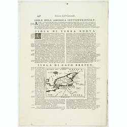
Isola di Capo Breton./ Isola e citta di cartagena Nell America.
An engraving of Cape Breton, from Isolario Dell'Atlante Vento.On verso a map of Cartagena (220x125mm.)
Date: Venice, 1690
Selling price: ????
Please login to see price!
Sold in 2018
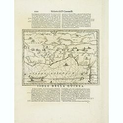
Isola della Guinea. / Isola Gore.
Fine map of Guinea, from Isolario Dell'Atlante Vento.On verso a map of the island Goeree (130x172mm).
Date: Venice, 1690
Selling price: ????
Please login to see price!
Sold in 2018
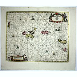
Insulae Flandricae olim Asores dictae.
Old map of the Azores, Including the island of Terceira. It was at the time an important port and administrative center of the island group. It is today the site of a U.S...
Date: Amsterdam, 1690
Selling price: ????
Please login to see price!
Sold in 2014

CONFUCIUS le Philosphe le plus estimé parmi les Chinois. . .
A very rare and decorative portrait of Confusius. Underneath the plate a descriptive text in French. Bears the address : A Paris Chez N. Langlois rue St.Jacques a l'Ensei...
Date: Paris, ca. 1690
Selling price: ????
Please login to see price!
Sold in 2012
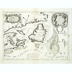
Canada Orientale nell' America Settentrionale . . .
Elaborate map of the Newfoundland and the mouth of the St. Lawrence, showing Nova Scotia, Cape Breton, Isle de Anticosti and Prince Edward Island.Two ornate cartouches. F...
Date: Venice, 1690
Selling price: ????
Please login to see price!
Sold in 2012
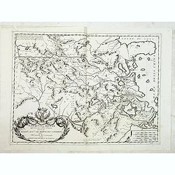
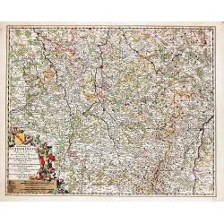
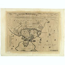
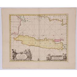
Ristretto Della Dalmazia Divisa Ne Suoi Contadi Gia Presentata Alla Serenissima Republica Di Venezia . . .
Elaborate two sheet map of the coast of Dalmatia, extending from Istria and Croatia in the north to Bosnia, Herzegovina, Serbia and Albania in the South. Two ornate carto...
Date: Venice, 1690
Selling price: ????
Please login to see price!
Sold in 2012
Territorio della citta di Forli . . .
Elaborate map centered on the town of Forli, south of Ravenna. Surrounded with 32 coats of arms. From Coronelli's rare Atlante Veneto, one of the most decorative and orna...
Date: Venice, 1690
Selling price: ????
Please login to see price!
Sold in 2012
Planisphaerium terrestre, cum utroque coelesti hemesphaerio, sive diversa orbis terraquei.
Published in Amsterdam in 1709, it presents 26 diagrams (!!!) 9 of which refers to different angles of the Earth, and the other to astronomical diagrams. Two larger diagr...
Date: Amsterdam, 1690
Selling price: ????
Please login to see price!
Sold in 2017
Recentissima Novi Orbis Sive Americae Septentrionalis et Meridionalis Tabula. . .
First state of Danckerts map of the Americas. California depicted as an Island, mostly based on Sanson second projection. The Great Lakes (also based on Sanson) and early...
Date: Amsterdam, 1690
Selling price: ????
Please login to see price!
Sold in 2012
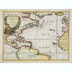
Mare del Nord.
Shows the Atlantic Ocean between Iceland, Europe, West-Africa, Brazil and Canada, including the Caribbean. Here Coronelli splendidly delineates the center of European eco...
Date: Venice, 1690
Selling price: ????
Please login to see price!
Sold in 2013
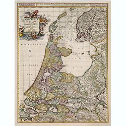
Hollandiae comitatus in esjudem subjacentes dittones..
Prepared after Dou and Broeckhuysen. The map bears a long Dutch and Latin title and is orientated to the north. It was engraved by G.Gouwen.
Date: Amsterdam, 1690
Selling price: ????
Please login to see price!
Sold in 2015
Vue de Chateau des Jardins et du Canal de Chantilly.
This print is from "Veues des Plus Beaux Lieux de France et d'Italie" published in Paris by Nicolas Lanlois in 1690. The prints in this book showcased the chate...
Date: Paris, 1690
Selling price: ????
Please login to see price!
Sold in 2013
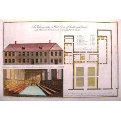
The Icthyography or Platform of Sedbergh School & Masters House, as it is designed to be built.
This large copper engraved print showed the front elevation, plan & interior view of the proposed school building. It was published & sold by Joseph Smith in Lond...
Date: London, 1690
Selling price: ????
Please login to see price!
Sold in 2014
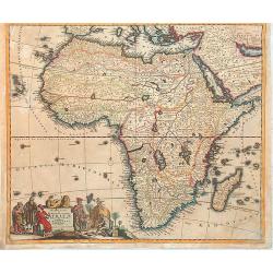
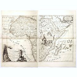
Novissima et perfectissima Africae descriptio
Uncommon map of Africa, based on De Wit map of 1680. Wildlife, ships and sea monsters reflects the new style of the eighteenth century. The cartouche includes Moorish tra...
Date: Amsterdam, 1690
Selling price: ????
Please login to see price!
Sold in 2013
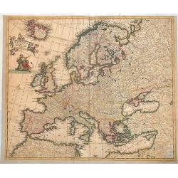
Accuratissima Europae tabula.
Scarce map of Europe by Danckerts. Full original colors.
Date: Amsterdam, 1690
Selling price: ????
Please login to see price!
Sold in 2013
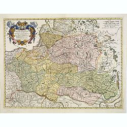
Tabula nova totius Regni Poloniae in quo sunt Ducatus et Provinciae Prussia, Cujavia, Mazovia, Russia, Nigra &c. Ducatus Lithuania, Ukrania...Volhynia et Podolia.
Map of Poland, Lithuania, Latvia, Belarus and Ukraine with decorative cartouche in the upper left corner showing two wind heads, a cheetah's head and two sets of bows and...
Date: Amsterdam, 1690
Selling price: ????
Please login to see price!
Sold in 2013
Novissima et Accuratissima Totius Americae.
An uncommon and elegant Dutch map of the Americas.
Date: Amsterdam, c.1690
Selling price: ????
Please login to see price!
Sold in 2014
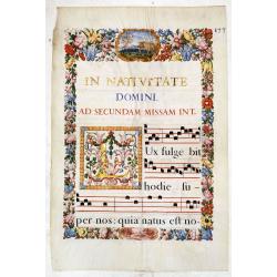
Leaf on vellum from an antiphonary.
A very fine antiphonary leaf with Gregorian music, text written in Latin, starting with "In Nativitate Domini ad secundam missam int." (In the Nativity of the L...
Date: France ?, about or shortly after 1690
Selling price: ????
Please login to see price!
Sold in 2015

Frontpiece from Veteres Arcus Augustorum Triumphis Insignes.
A finely copper-engraved dedication portrait frontispiece by Lucatellus depicting Cardinal Pietro Ottoboni in an oval frame surrounded by a lovely baroque setting. Ottobo...
Date: Rome, 1690
Selling price: ????
Please login to see price!
Sold in 2014
Isola de Re, nel Mare di Guascogna . . .
A beautiful and rare map showing Isle de Ré. The title cartouche is held by and trumpet-blowing angel.The remarkable Vincenzo Coronelli (1650-1718), encyclopaedist, geog...
Date: Venice, 1690
Selling price: ????
Please login to see price!
Sold
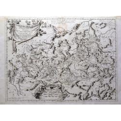
Tabula Russia Vulgo Moscovia.
A detailed map including all western Russia and most of Finland. With very decorative title cartouche.
Date: Amsterdam, 1690
Selling price: ????
Please login to see price!
Sold in 2014
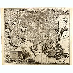
Exactissima Asiae Delineatio In Praecipuas Regiones . . .
Fine map of Asia and the and the Northern tip of Australia, called Hollandia Nova. With a very decorative title cartouche lower left featuring camels, cockatoos and Easte...
Date: Amsterdam, ca.1690
Selling price: ????
Please login to see price!
Sold in 2014
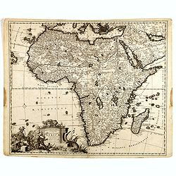
Totius Africae . . .
The detail of the map includes the traditional depiction of Central Africa with the river Nile rising in two large central Lakes Zaire and Zaflan. The West African river ...
Date: Amsterdam, 1690
Selling price: ????
Please login to see price!
Sold in 2014
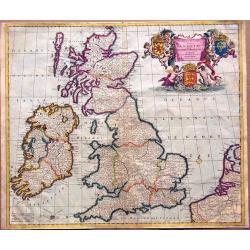
Novissima et Accuratissima Totius Angliae, Scotiae et Hiberniae Tabula.
An extremely decorative, uncommon map of the British Isles, with a superb title cartouche featuring putti holding up the arms of England, Scotland and Ireland, in full co...
Date: Amsterdam, ca 1690
Selling price: ????
Please login to see price!
Sold in 2014
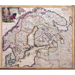
Accuratissima regnorum sueciae, daniae et norvegiae tabula.
Uncommon map of the Scandinavian peninsula with a large, very decorative title cartouche in upper left corner.Includes Sweden, Denmark, Norway and a part of Russia.
Date: Amsterdam, 1690
Selling price: ????
Please login to see price!
Sold in 2014
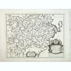
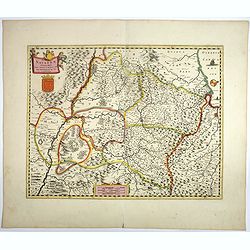
Generalis Lotharingiae Ducatus Tabula
Frederik de Wit (1610-98), Amsterdam-based cartographer and publisher. ' Atlas minor', 1670, ' Zee-Atlas', 1675, ' Atlas Major', 1690.An attractive map of Lorraine. Embel...
Date: Amsterdam, F. de Wit, c.1690
Selling price: ????
Please login to see price!
Sold in 2020
Nieuwe Paskaert Vande Gehele Westersche Scheep-vaert.
Johannes van Keulen was the founder of the successful van Keulen firm that published charts, pilot guides, and sea atlases for over 2 centuries. In 1680 he published his ...
Date: Amsterdam, c. 1690
Selling price: ????
Please login to see price!
Sold in 2018
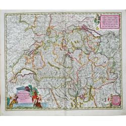
Exactissima Helvetiae Rhetiae, Valesia Tabula.
Nicolaas Visscher (1618-1679), son of Claes Jansz. Visscher Atlas Contractus (1657), Atlas Minor.Nicolaas Visscher's attractive map of Switzerland. Embellished with a fin...
Date: Amsterdam, F. de Wit, c.1690
Selling price: ????
Please login to see price!
Sold in 2017

Neueste Beschreibung des ganzen Rheinstroms...
Rare large map illustrating the course of the Rhine river. The map is surrounded by 20 city plans, including Cologne, Bonn, Speyer, Mainz, Heidelberg, Worms, Basel, Stras...
Date: Nuremberg, 1690
Selling price: ????
Please login to see price!
Sold in 2015
![Terre Artiche... [Arctic]](/uploads/cache/94033-250x250.jpg)
Terre Artiche... [Arctic]
Coronelli's map of the Arctic Circle, illustrating a speculative Northwest Passage and Northeast Passage around the North Pole. The American place names are given by Engl...
Date: Venice, c. 1690
Selling price: ????
Please login to see price!
Sold in 2014
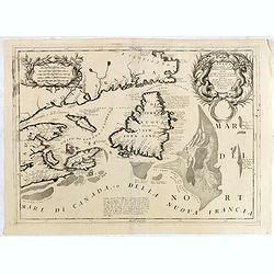
Canada Orientale nell' America Settentrionale ..
Elaborate map of the Newfoundland, Labrador, Nova Scotia and the Gulf of St. Lawrence. Two ornate cartouches. From Coronelli's rare Atlante Veneto, one of the most decora...
Date: Venice, 1690
Selling price: ????
Please login to see price!
Sold in 2015
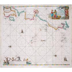
OOST INDIEN Wassende-Graade Paskaart, vertoonende nevens het Oosterlykste van Afrika, meede de Zeekusten van Asia, van C. de Bona Esperance tot Eso, boven Japan. . .
Sea chart of the East Indies on Mercator projection delineating not only the eastern coast of Africa, but also the coasts of Asia, from the C. of Good Hope till Eso, nort...
Date: Amsterdam, ca. 1690
Selling price: ????
Please login to see price!
Sold in 2015
Anno HAFNIA Daniae met: COPPENHAGEN 1659.
During the Northern Wars, the Swedish army under Charles X Gustav of Sweden, after invading the Danish mainland of Jutland, swiftly crossed the frozen straits and occupie...
Date: Amsterdam, ca. 1690
Selling price: ????
Please login to see price!
Sold in 2017
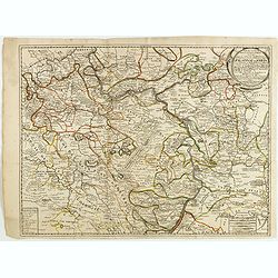
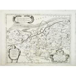
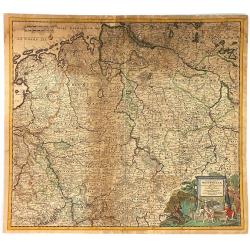
Partie des cercles du Haut et Bas Rhein ou sont partie des archevechez de Mayence et de Treves, et les evechez de Wormes et Spire, le Palatinat du Rhein, et les Palatinats de Birkenfelt et de Lautereck. . .
An attractive map of central part of Germany with river Rhine and centered on Manheim. This large one-sheet map was produced by the Venetian cosmographer Vincenzo Coronel...
Date: Paris, 1690
Selling price: ????
Please login to see price!
Sold in 2015
Iunan, Queicheu, e Quangsi Provincie della China...
Large early map of the Chinese provinces of Yunan, Guizhou, Guangxi, from Coronellis "Corso Geografico Universalle".The map includes many place names and topogr...
Date: Venice, c1690
Selling price: ????
Please login to see price!
Sold in 2015
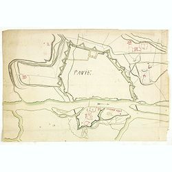
Pavie.
Manuscript drawing of the street layout and fortifications of the town of Pavia, in south-western Lombardy, northern Italy.Ticinum (the modern Pavia) was an ancient city ...
Date: ca. 1690
Selling price: ????
Please login to see price!
Sold
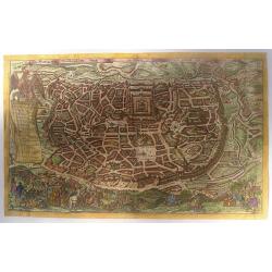
Die Heylige und Weitberümte Statt Ierusalem, erstlich genant Salem Genesis 14 vers. 13.
This copperplate engraving of "Die Heylige und Weitberümte Statt Ierusalem. . ." was published in a German Bible. The plan is drawn after Claes Janszoon Vissch...
Date: Germany, ca 1690
Selling price: ????
Please login to see price!
Sold in 2015
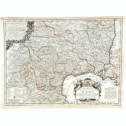
Le gouvernement général de Languedoc divisé en Haut et Bas Languedoc et Sévennes par N. de Fer, géographe de sa majesté catolique. . .
Scarce map by J.-B. Nolin, after Sr. Tillemon.
Date: Paris, ca. 1690
Selling price: ????
Please login to see price!
Sold in 2015
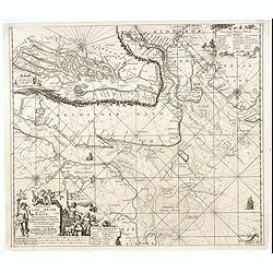
Paskaart vande Jade, Weser en Elve..
The map extends from Helgoland to the estuaries of Jade, Weser and The Elbe. On the bottom left is the title cartouche stating the manufacturer Johannes van Keulen The te...
Date: Amsterdam, 1690
Selling price: ????
Please login to see price!
Sold in 2016
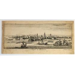
Tripoli de Barbaria.
Fine bird's eye view of the city of Tripoli, Lybia. Etched in about 1690 by Gaspar Bouttats (1640-1695).The Antwerp based publisher, Jacques Peeters, published ca. 1690 a...
Date: Antwerp, c. 1690
Selling price: ????
Please login to see price!
Sold in 2017
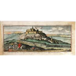
Nitria (Slovakia)
Fine bird's eye view of the city of Nitra, Slovakia. Etched in about 1690 by Gaspar Bouttats (1640-1695). The Antwerp based publisher, Jacques Peeters, published ca. 1690...
Date: Antwerp, 1690
Selling price: ????
Please login to see price!
Sold in 2018
Disegni Di Vari Altari E Cappelle Nelle Chiese Di Roma : con le loro facciate, fianchi, piante e misure de piu celebri architetti (Frontispiece)
This is the frontispiece from Cornice Architecttonica Con Figure Allegoriche, featuring engravings of various altars and chapels in the churches of Rome with their facade...
Date: Milan, 1690
Selling price: ????
Please login to see price!
Sold in 2015
Geographica Artesiae Comitatus Tabula.
A fine large map of the region of Artois by Nicolaes Visscher II, produced in Amsterdam in 1690. Beautiful embellishments such as decorative cartouches, five putti, and ...
Date: Amsterdam, 1690
Selling price: ????
Please login to see price!
Sold in 2021
Funfkirchen...
A striking bird's eye view of Pecs. Etched by Gaspar Bouttats. The Antwerp based publisher, Jacques Peeters published a series of prints related to the Habsburg-Ottoman w...
Date: Antwerp. c1690
Selling price: ????
Please login to see price!
Sold in 2019

Margarita Romanorum Imperatrix, nata regia Hispaniarum Infans.
Half-length portrait of Margaret Theresa of Spain (12 July 1651 – 12 March 1673) by Bartholome Kilian (1630-1696). She was Holy Roman Empress, German Queen, Archduchess...
Date: Augsburg, ca. 1690
Selling price: ????
Please login to see price!
Sold in 2017
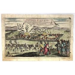
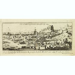
Fortezza d' San Giob Presa dell'Armi Imperiali li 12 Febraro 1686.
Striking, decorative, copper engraved plate showing the siege of St. Giob Fortress in Budepest, Hungary in 1686.
Date: Paris, ca. 1690
Selling price: ????
Please login to see price!
Sold in 2019
Circulus Westphaliae cum Omnibus Suis Subjacentibus....
The circle of Westphalia and surrounding area of Germany. Very detailed map by Justus Dankerts in the Netherlands. The Danckerts family was very large and had a lot of m...
Date: Amsterdam, 1690
Selling price: ????
Please login to see price!
Sold in 2016
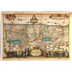
Canaan, or The Land of Promise, Possessed by the Children of Israel and Travelled through by our Saviour Jesus Christ; and His Apostles
This fine religious map of present-day Israel is oriented with north to the right. There is a large, decorative title cartouche at bottom flanked by four vignettes depic...
Date: Amsterdam, 1690
Selling price: ????
Please login to see price!
Sold in 2016
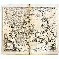
Archipelagi et Graecia Universae.
Centered on Greece. Very decorative title cartouche in the lower left-hand corner.
Date: Amsterdam, 1690
Selling price: ????
Please login to see price!
Sold in 2016
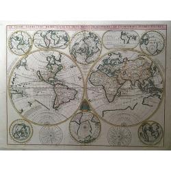
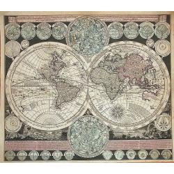
Le Globe Terrestre Represente en Deux Plans-Hemispheres, et en Diverses autres Figures..
A copper-engraved double-hemisphere map of the world, surrounded by smaller hemispherical and oval maps, hand-colored in outline.Significant world map at the end of the 1...
Date: Paris, 1690
Selling price: ????
Please login to see price!
Sold in 2017
Isola della Guinea.
Fine map of Guinea, from Isolario Dell'Atlante Vento. The sheet dimension is 485x350mm. Information is largely confined to the coast and the Niger River, which flows in p...
Date: Venice, 1690
Selling price: ????
Please login to see price!
Sold in 2018
Regni Navarrae. . .
Centred on Pamplona. Orientated west to the top.
Date: Amsterdam, 1690
Selling price: ????
Please login to see price!
Sold in 2018
![[Title page] Atlas Minor sive totius Orbis Terrarum..](/uploads/cache/39700-250x250.jpg)
[Title page] Atlas Minor sive totius Orbis Terrarum..
Finely etched title page from Visscher's "Atlas Minor". Showing Atlas supporting the World, and Neptune seated astride a terrestrial globe, showing the Atlantic...
Date: Amsterdam, 1690
Selling price: ????
Please login to see price!
Sold in 2017
Insulae Iavae Cum parte insularum Borneo Sumatrae.
A beautiful map of Java and parts of the islands Borneo, Sumatra and Bali. Only the coast is indicated in detail with Batavia (Jakarta) top left .The map is enhanced with...
Date: Amsterdam, 1690
Selling price: ????
Please login to see price!
Sold in 2017
L'AFRICA divisa nelle sue Parti secondo le pui moderne..
A beautiful and rare two-sheet map of Africa. The title cartouche is depicted on a drape surrounded by native animals.A most noticeable feature of the decoration on the m...
Date: Venice, 1690
Selling price: ????
Please login to see price!
Sold in 2018
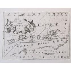
Le Molucche, Dedicate al Molto Rev: Pre Maestro Carlo Tosi, Min Congio Provinceale.
An uncommon engraved map of the Maluku or Moluccas Islands in Indonesia. In the past the islands were also known as the 'Spice Islands'. The islands are shown with their ...
Date: Venice, ca. 1690
Selling price: ????
Please login to see price!
Sold in 2017
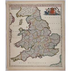
Anglia Regnum In Omnes Suos Ducatus, Comitatus, et Provincias Divisum.
Decorative map of England and Wales showing immense detail of the cities and towns, colored by counties. Very decorative cartouche with mermaids holding up the arms of En...
Date: 1690
Selling price: ????
Please login to see price!
Sold in 2018
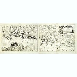
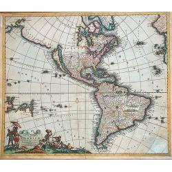
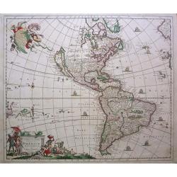
![America Settentrionale Colle Nuove Scoperte Sin All Anno 1688. . . (together with] America meridionale . . .](/uploads/cache/40673-250x250.jpg)
America Settentrionale Colle Nuove Scoperte Sin All Anno 1688. . . (together with] America meridionale . . .
Gorgeous example of Coronelli's famous four- sheet map of America. One of the best examples of California as an island. The map also includes extensive annotations on the...
Date: Venice, 1690
Selling price: ????
Please login to see price!
Sold in 2018
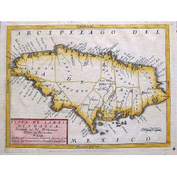
Isola de Iames, o Giamaica. . .
A decorative map of Jamaica with many details, bays, islands, and shows all the islands different parishes.
Date: Venice, ca. 1690
Selling price: ????
Please login to see price!
Sold in 2017
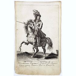
Leopoldus de Eerste door G. G. Roomsch Keijser Gekooren.
Equestrian portrait of the Holy Roman Emperor Leopold I, full-length in profile to left but looking at the viewer, horse seen in frontal view, after Pieter Stevens ( c.16...
Date: Antwerp, c.1690
Selling price: ????
Please login to see price!
Sold in 2019

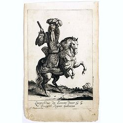
Graaf Emmerics Tekkelÿ Opperhoofd . . .
Equestrian portrait of Emmerics Tekkelÿ, full-length in profile to left but looking at the viewer, horse seen in frontal view, after Pieter Stevens ( c.1683-1692)This is...
Date: Antwerp, c.1690
Selling price: ????
Please login to see price!
Sold in 2019

Julius Franciscus D.G. Saxon . . .
Equestrian portrait of Julius Franciscus, full-length in profile to left but looking at the viewer, horse seen in frontal view, after Pieter Stevens ( c.1683-1692).This i...
Date: Antwerp, c.1690
Selling price: ????
Please login to see price!
Sold in 2019

Johannes III D.G. Polonorum . . .
Equestrian portrait of Johannes III, full-length in profile to left but looking at the viewer, horse seen in frontal view, after Pieter Stevens ( c.1683-1692).This is one...
Date: Antwerp, c.1690
Selling price: ????
Please login to see price!
Sold in 2018

Carel de 2 door G. G Koning van Spangien.
Equestrian portrait of Carel de 2nd, full-length in profile to left but looking at the viewer, horse seen in frontal view, after Pieter Stevens ( c.1683-1692).This is one...
Date: Antwerp, c.1690
Selling price: ????
Please login to see price!
Sold in 2019
Maximilianus Emanuel D. G. S R Imperii Elector Bavaria.
Equestrian portrait of Maximilianus Emanuel, full-length in profile to left but looking at the viewer, horse seen in frontal view, after Pieter Stevens ( c.1683-1692).Thi...
Date: Antwerp, c.1690
Selling price: ????
Please login to see price!
Sold in 2019
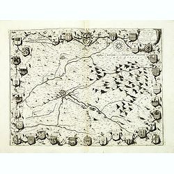
![Del Palatinato, et Elettorato Del Reno Parte Orientale... [and] Descritta Dal P. Coronelli Cosmografo della Serema. Repuca.](/uploads/cache/81112-250x250.jpg)
Del Palatinato, et Elettorato Del Reno Parte Orientale... [and] Descritta Dal P. Coronelli Cosmografo della Serema. Repuca.
A large 2-sheet, detailed and decorative map of the Rhine Valley from Coronelli’s Corso Geografico Universale, published in Venice in 1690.The map shows the eastern par...
Date: Venice, 1690
Selling price: ????
Please login to see price!
Sold in 2018

Ernest Rudiger, Grave van Starrenberg . . .
Equestrian portrait of Ernest Rudiger, full-length in profile to left but looking at the viewer, horse seen in frontal view, after Pieter Stevens ( c.1683-1692) was milit...
Date: Antwerp, c.1690
Selling price: ????
Please login to see price!
Sold in 2018
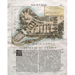
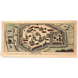
Castello di Candia descritto, e dedicato. . .
An uncommon engraved plan of the castle of Candia (Heraklion, Crete) on a large sheet with Italian text below and on verso. From Coronelli's famous Isolario atlas. Corone...
Date: Venice, ca. 1690
Selling price: ????
Please login to see price!
Sold in 2018
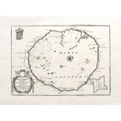
Isola di Maria Galante nell Antilli. . .
One of the few separate maps of the island of Marie Galante, showing sugar plantations, and (curiously) some large trees. Fort Moliere is shown in a small inset. Small pe...
Date: Venice, ca. 1690
Selling price: ????
Please login to see price!
Sold in 2018
Abissinia, doue sono le Fonti del Nilo.
This very uncommon map concentrates of the source of the Blue Nile in a lake called Tzana, Dembea, which Coronelli claimed to be the first to accurately depict.Extensive ...
Date: Venice, 1690
Selling price: ????
Please login to see price!
Sold in 2018