Browse Listings
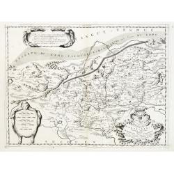
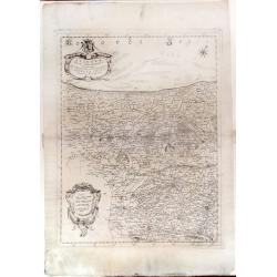
Xansi, e Xensi, Provincie della Cina..
A beautiful map depicting part of China and showing a stretch of the Great Wall of China. With decorative title cartouche, scale cartouche and a cartouche containing some...
Date: Venice 1690
Selling price: ????
Please login to see price!
Sold
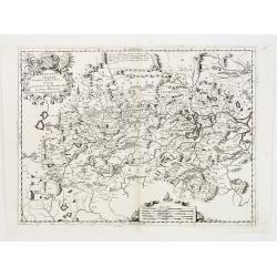
Hunouang, e Sucuhen, Provincie della Cina..
A beautiful map depicting part of China with decorative title cartouche and scale cartouche. Information about the area at the top of the map.The remarkable Vincenzo Coro...
Date: Venice 1690
Selling price: ????
Please login to see price!
Sold
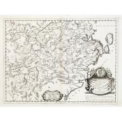
Chekiang, e Kiangsi, Provincie della Cina..
A beautiful map depicting part of China with decorative scale cartouche as well as some information about the area in the lower right corner, surmounted by an impressive ...
Date: Venice 1690
Selling price: ????
Please login to see price!
Sold
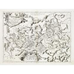
Iunan, Queichev, e Quangsi Provincie della Cina..
A beautiful map depicting part of China with decorative title cartouche and scale cartouche. Information about the area at the top of the map.The remarkable Vincenzo Coro...
Date: Venice 1690
Selling price: ????
Please login to see price!
Sold
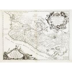
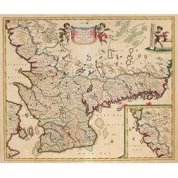
Parte della Nuova Spagna, o del Mexico dove sono le Provincie di Guadalaira Xalisco Mecoacan e Mexico..
A beautiful map depicting western Mexico covering the area along the Pacific Coast from Xiamora to Acapulco, with a vivid portrayal of the volcano of Popocatepec. With im...
Date: Venice 1690
Selling price: ????
Please login to see price!
Sold
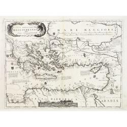
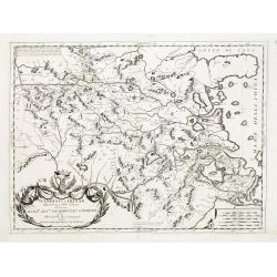
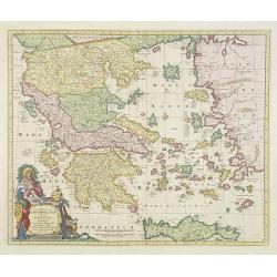
Parte Orientale del Mediterraneo..
A beautiful map depicting the eastern part of the Mediterranean Basin, including a nice representation of Cyprus. With decorative title cartouche and scale cartouche.Hist...
Date: Venice 1690
Selling price: ????
Please login to see price!
Sold
Isole Azzori, o Azzoridi dette altrimenti Acipitrum, Tertiae, Flandricae, et Superiores..
A beautiful and highly decorative map of the Azores Islands. With large title cartouche in the upper right corner decorated with coral, fish, seaweeds and pearl chains.In...
Date: Venice 1690
Selling price: ????
Please login to see price!
Sold
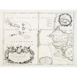
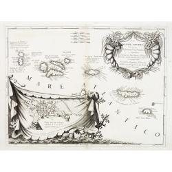
Bocche del Fiume Negro et Isole di Capo Verde..
This is a splendid map of the northwestern coast of Africa and the Cape Verde Islands.The map provides details of the various Portuguese discoveries in the region in the ...
Date: Venice 1690
Selling price: ????
Please login to see price!
Sold in 2008
Nanking, et Honan Provincie della China..
A beautiful map depicting part of China with Nanking (Jiangsu) and Honan (Henan), with decorative title cartouche and scale cartouche. Information about the area in the u...
Date: Venice 1690
Selling price: ????
Please login to see price!
Sold
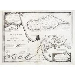
Isole Canarie..
Decorative and highly detailed map of the Islands of the Canaries and Madeira, with a large inset of the port of Funchal. Includes two decorative cartouches.The remarkabl...
Date: Venice 1690
Selling price: ????
Please login to see price!
Sold
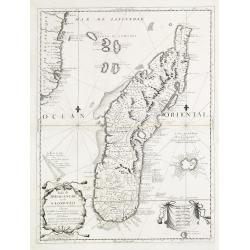
Isola di Madagascar o di S. Lorenzo Scoperta dà Portoghesi nell anno 1506..
Decorative and highly detailed map of Madagascar, including 2 decorative cartouches and other embellishments.The remarkable Vincenzo Coronelli (1650-1718), was a Francisc...
Date: Venice 1690
Selling price: ????
Please login to see price!
Sold
Corso del Fiume dell Amazoni..
An uncommon map of the northern half of the continent focusing on the course of the Amazon River.Typical of Coronelli's strong engraving style the topographical features ...
Date: Venice 1690
Selling price: ????
Please login to see price!
Sold
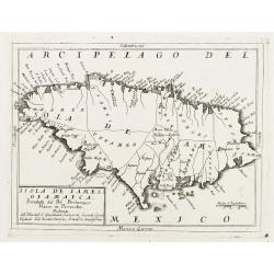
Isola de Iames, o Giamaica..
Map of Jamaica by the remarkable Vincenzo Coronelli, (1650-1718), a Franciscan Friar and appointed General of the Order in 1701.He was cosmographer to the Republic of Ven...
Date: Venice 1690
Selling price: ????
Please login to see price!
Sold
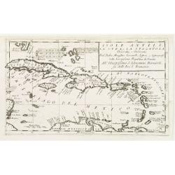
Isole Antili, La Cuba, e La Spagnuola..
Map of the Caribbean Islands by the remarkable Vincenzo Coronelli, (1650-1718), a Franciscan Friar and appointed General of the Order in 1701.He was cosmographer to the R...
Date: Venice 1690
Selling price: ????
Please login to see price!
Sold
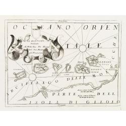
Le Molucche..
Map of the Moluccas Islands with decorative title cartouche. West to the top. By the remarkable Vincenzo Coronelli, (1650-1718), a Franciscan Friar and appointed General ...
Date: Venice 1690
Selling price: ????
Please login to see price!
Sold
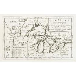
La Lovisiana, Parte Settentrionalle, Scoperta sotto la Protettione di Luigi XIV, Rè di Francia..
One of the most important maps of the Great Lakes and Upper Mississippi, based upon reports of La Salle, Hennepin, Marquette, Jolliet and other French Jesuits who were ac...
Date: Venice 1690
Selling price: ????
Please login to see price!
Sold
![[Untitled: La Guinea].](/uploads/cache/23454-250x250.jpg)
[Untitled: La Guinea].
Charming small map of the west coast of Africa centered on the Gulf of Guinea covering the coast from the Ivory coast as far as Gabon.The remarkable Vincenzo Coronelli (1...
Date: Venice 1690
Selling price: ????
Please login to see price!
Sold
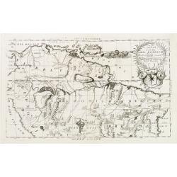
Abissinia, doue sono le Fonti del Nilo..
This very uncommon map concentrates of the source of the Nile in a lake called Tzana, Dembea, which Coronelli claimed to be the first to accurately depict.Extensive notat...
Date: Venice 1690
Selling price: ????
Please login to see price!
Sold
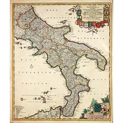
Regnum Neapolis.
Frederik de Wit (1610-98), Amsterdam-based cartographer and publisher. ' Atlas minor', 1670, ' Zee-Atlas', 1675, ' Atlas Major', 1690.An attractive map of the Knigdom of ...
Date: Amsterdam, 1690
Selling price: ????
Please login to see price!
Sold
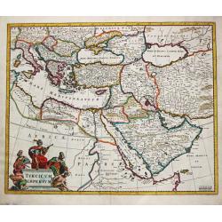
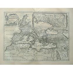
Turcicum Imperium.
Frederick de Wit (1610-1698) became after the closing of the Blaeu firm one of the most important Amsterdam-based publishers. He published several atlases, Atlas Minor (1...
Date: Amsterdam, 1690
Selling price: ????
Please login to see price!
Sold
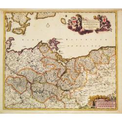
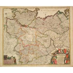
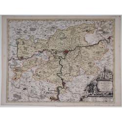
Marchionatus Brandenburgi et Ducatus Pomeraniae Tabula.
Frederik de Wit (1610-98), Amsterdam-based cartographer and publisher. ' Atlas minor', 1670, ' Zee-Atlas', 1675, ' Atlas Major', 1690.An attractive map of Brandenburg and...
Date: Amsterdam, c.1690
Selling price: ????
Please login to see price!
Sold in 2008
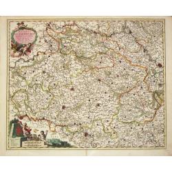
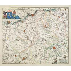
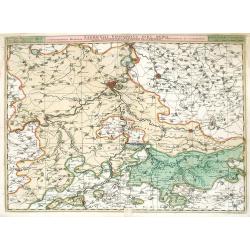
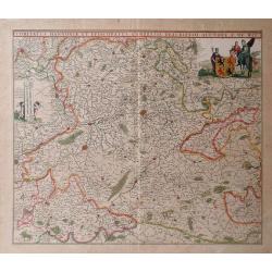
Circulus Westphalicus in quo sunt Episcopatus Monarsteriensis Paderbornensis et Osnabrugiensis, Ducatus Iuliasnensis, Clivensis, et Montensis, Principatus Mindensis, Ferdensis et Frisiae Orientalis, Comitatus Marchiae &c.
Frederik de Wit (1610-98), Amsterdam-based cartographer and publisher. ' Atlas minor', 1670, ' Zee-Atlas', 1675, ' Atlas Major', 1690.An attractive map of Rheinland-Westf...
Date: Amsterdam, c.1690
Selling price: ????
Please login to see price!
Sold in 2017
Ciculis Saxoniae Inferioris in quo sunt Ducatus Holsatiae Mecklenburgi, Lauwenburgi, Luneburgi, Brunsuigi, Bremae et Ferdae, Comitatus Dannebergi, Archiepiscopatus Maegdenburgensis, Episcopatus Hildesiae et Halberstad.
An attractive map of Niedersachsen and Hamburg-Holstein. Embellished with a title-cartouche with the coats-of-arms and a cartouche with scales. From Frederick de Wit's &q...
Date: Amsterdam, c.1690
Selling price: ????
Please login to see price!
Sold in 2019
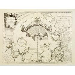
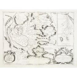
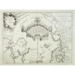
Terre Artiche.
A beautiful and rare map showing the Arctic circle, the northern parts of Canada, Europe and Siberia.A central circular panel of text is surrounded by a glacial frame. Th...
Date: Venice, 1690
Selling price: ????
Please login to see price!
Sold
Ducatus Lutzenburgi Novissima et accuratissima Delineatio
Frederik de Wit (1610-98), Amsterdam-based cartographer and publisher. ' Atlas minor', 1670, ' Zee-Atlas', 1675, ' Atlas Major', 1690.Nicolaas Viischer's attractive map o...
Date: Amsterdam, F. de Wit, c.1690
Selling price: ????
Please login to see price!
Sold in 2011
Tabula ducatus Limburch et comitatus Valckenburch. . .
The map describes the southern part of Limburg and reaches into Belgium (Liége, Verviers) and Germany. With two very decorative cartouches.
Date: Amsterdam, 1690
Selling price: ????
Please login to see price!
Sold in 2021
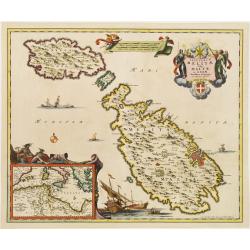
Insularum Melitae vulgo Maltae et Gozae. . .
A very attractive example of this detailed map of Malta and Gozo with inset map of the Western Mediterranean. Sailing ships and a large title cartouche with the Coat of A...
Date: Amsterdam, 1690
Selling price: ????
Please login to see price!
Sold in 2008
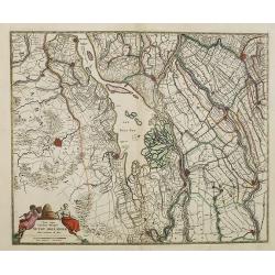
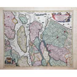
Nova atque emendata descriptio Suydt Hollandiae edita a Frederico de Wit.
Detailed map covering the area around the Biesbos, including Breda, Willemstad, Dordrecht, Culembourg, Gorichem and Gouda.The map is oriented with west at the top. Superb...
Date: Amsterdam, 1690
Selling price: ????
Please login to see price!
Sold in 2011
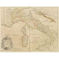
Italia Antiqua.
A fine map of Ancient Italy. This edition carries the date 1690, in manuscript.Nicolas Sanson was to bring about the rise of French cartography, although the fierce compe...
Date: Paris, 1690
Selling price: ????
Please login to see price!
Sold in 2023
![[Globe Gore of the Arabian Sea]](/uploads/cache/26333-250x250.jpg)
[Globe Gore of the Arabian Sea]
Originally engraved to be pasted onto a globe in 1688, this edition was printed with a text underneath it. It shows the Arabian Sea from Oman to Sri Lanka, with a roundel...
Date: Venice, 1690
Selling price: ????
Please login to see price!
Sold in 2011
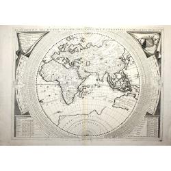
Planisfero del Mondo Nuovo, Descritto dal P. Coronelli, Cosmografo Publico.
A very fine map of the Eastern hemisphere including the discoveries made by Abel Tasman in Australia. The decorative borders include co-ordinates and descriptions of sign...
Date: Venise, c. 1690
Selling price: ????
Please login to see price!
Sold in 2012
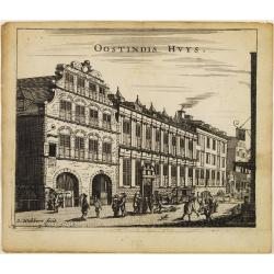
Oostindis Huys.
A decorative print of the East Indian House , the headquarters of the V.O.C., a place for meeting, trading and storage of spices and ship equipment.The maps and charts we...
Date: Amsterdam, c. 1690
Selling price: ????
Please login to see price!
Sold in 2011
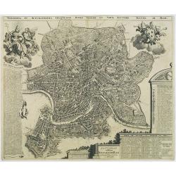
Novissima et accuratissima delineatio Romae veteris et noavae auctore Joanne de Ram.
A very detailed and decorative bird's-eye view of the town copied after J.B.Falda (1670). Two decorative cartouches and key insets to churches (1-266), Grave tombes(267-3...
Date: Amsterdam, 1690
Selling price: ????
Please login to see price!
Sold in 2009
Geographische Beschryvinghe van de Wandeling der Apostelen ende De Reysen Pauli, ...
Bible map of the Eastern part of the Mediterranean Sea. A somewhat under valuated "carte à figures" map !
Date: Amsterdam, ca. 1690
Selling price: ????
Please login to see price!
Sold in 2010
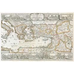
Exactissima totius Archipelagi nec non Graeciae tabula.
Key map of the Greek Islands, the Aegean, Crete and part of Asia Minor.
Date: Amsterdam, 1690
Selling price: ????
Please login to see price!
Sold in 2009
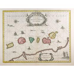
Insularum Moluccarum Nova descriptio.
The small spice islands off the west coast of the island of Halmahera in the eastern part of the archipelago. With an imposing title cartouche, together with finely drawn...
Date: Amsterdam, 1690
Selling price: ????
Please login to see price!
Sold in 2012
Accurata Scaniae Blekingae, et Hallandiae . . .
With an inset showing the coast from Gothenburg till Warberg.
Date: Amsterdam, 1690
Selling price: ????
Please login to see price!
Sold in 2011
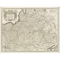
Tabula nova totius regni Poloniae..
Map of Poland, Lithuania, Latvia, Belarus and Ukraine with decorative cartouche in the upper left corner.Published by Nicolaas Visscher after N. Sanson.
Date: Amsterdam, 1690
Selling price: ????
Please login to see price!
Sold in 2009
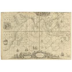
OOST INDIEN Wassende-Graade Paskaart, vertoonende nevens het Oosterlykste van Afrika, meede de Zeekusten van Asia, van C. de Bona Esperance tot Eso, boven Japan. . .
(Sea chart of the East Indies on Mercator projection delineating not only the eastern coast of Africa, but also the coasts of Asia, from the C. of Good Hope till Eso, nor...
Date: Amsterdam, ca.1690
Selling price: ????
Please login to see price!
Sold in 2010
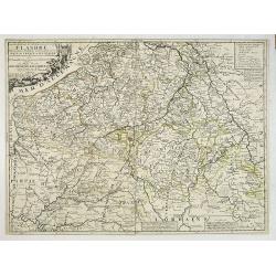
La partie Meridionale des Pays-Bas, Connue sous le nom de FLANDRE divisée en plusieurs Provinces. . .
Although the title cartouche states Flanders, or the Spanish part of the 17 provinces of the Low Countries, the map shows present-day Belgium. Title cartouche on the uppe...
Date: Paris, 1690
Selling price: ????
Please login to see price!
Sold in 2022
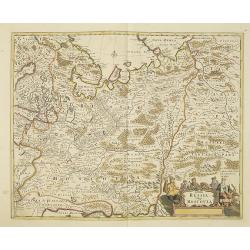
Tabula Russia Vulgo Moscovia.
A detailed map including all western Russia and most of Finland. With very decorative title cartouche.
Date: Amsterdam, 1690
Selling price: ????
Please login to see price!
Sold in 2011
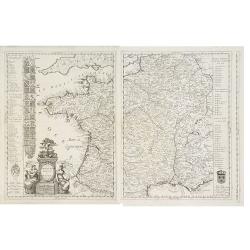
La Francia Antica, e Moderna Dedicata.
A beautiful and rare map in two sheets showing France. To the left coats of arms of the different provinces. With a dedication to Michael Sagramoso. The remarkable Vincen...
Date: Venice, 1690
Selling price: ????
Please login to see price!
Sold in 2012
Comitatus Namurci Tabula.
Carol Allard map of Belgium, shows the city of Namur in the center.
Date: Amsterdam, 1690
Selling price: ????
Please login to see price!
Sold in 2010
Terre Artiche.
A beautiful and rare map showing the Arctic circle, the northern parts of Canada, Europe, Russia and Siberia. Only northern half of Iceland is shown.A central circular pa...
Date: Venice, 1690
Selling price: ????
Please login to see price!
Sold in 2010
Leodiensis Episcopatus Pars Media, Comprehendens Hasbania Comitatum, Franchimontis Marchionatum, Stabulensem Principatum et Condrustum.
Fine map of the Liege region of Belgium including rivers, towns, and cities. The cities of Leige, Huy and Limburg are depicted.
Date: Amsterdam, 1690
Selling price: ????
Please login to see price!
Sold in 2010
Fiandra parte occidentale: dedicata all\'illustrissimo et eccelententissimo S. Giorgio Cocco, senatore meritissimo. . .
Map of the northern part of Flanders divided between France and Belgium. From the North Sea south, including major cities along the coast such as Dunkerque, France and Oo...
Date: Venice, c. 1690
Selling price: ????
Please login to see price!
Sold in 2010
Delflandia, Schielandia et circumjacentes Insulae ut Voorna, Overflackea, Goerea, Yselmonda et aliae.
Detailed map of Southern Holland, which includes the cities of The Hague (Gravenhag), Rotterdam, Willemstad, Gouda and Delft (Delet). Ships and naval battles are shown th...
Date: Amsterdam, 1690
Selling price: ????
Please login to see price!
Sold in 2010
Comitatus Hnnoniae et Episcopatus Cambresis Descriptio.
Map of the Belgium province of Hainault or Henegouwen by Frederick De Witt depicting major cities such as Arte, Chimay and Philippeville and major rivers and forests in t...
Date: Amsterdam, 1690
Selling price: ????
Please login to see price!
Sold in 2010
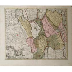
Hollandiae Pars Meridionalior Vulgo Zuyd-Holland.
A regional map of Holland by Nicholas Visscher depicting major cities such as Breda, Gouda and Gorcum and major river systems and bodies of water. A very detailed cartouc...
Date: Amsterdam, circa 1690
Selling price: ????
Please login to see price!
Sold in 2010
Chnin/Fortezza nella Dalmatia. Conqustata alla SS. Republica di Venetia. Dall eccellenza del sig. Cau: proc: Girolamo Corner/Generale De Dalmatia et Albania etc: Dedicata/ All' Illustrissimo Sig: Catarino Primogenita Suo.
Vincenzo Coronelli was both cleric and encyclopedist, with a particular interest in geography and cartography. He joined the Franciscan Order in Venice in 1665 and six ye...
Date: Venice, 1690
Selling price: ????
Please login to see price!
Sold in 2010
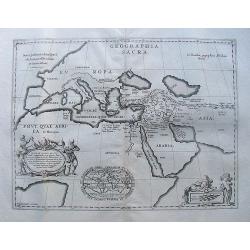
Geographia sacra.
From the Hornius edition of the atlas of the Ancient World by Janssonius. No text on verso.
Date: Amsterdam, ca 1690
Selling price: ????
Please login to see price!
Sold in 2010
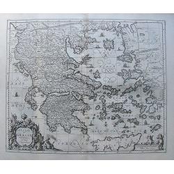
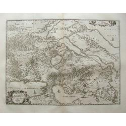
Hellas seu Graecia universa.
From the Hornius edition of the atlas of the Ancient World by Janssonius. No text on verso.After J. Laurenbergio / Nicholas Visscher.
Date: Amsterdam, ca 1690
Selling price: ????
Please login to see price!
Sold in 2012
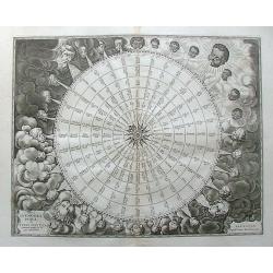
Tabula Anemographica seu Pyxis Nautica Ventorum nomina sex linguis representans.
From the Hornius edition of the Ancient Atlas by Janssonius. No text on verso. hemispherical engraved diagram of the winds surrounded by numerous windheads, central compa...
Date: Amsterdam, ca 1690
Selling price: ????
Please login to see price!
Sold in 2011
Tribus Ruben, et Gad et partes orientales tribuum Beniamin, Ephraim, et dimidiae Manasse intra Iordanem
From the Hornius edition of the Ancient Atlas by Janssonius. No text on verso.One of the six leaf map of Israel and Palestine.
Date: Amsterdam, ca 1690
Selling price: ????
Please login to see price!
Sold in 2012
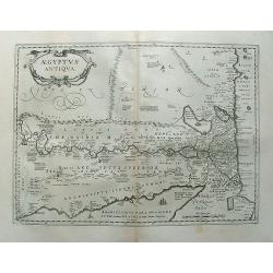
Aegyptus antiqua.
From the Hornius edition of the Ancient Atlas by Janssonius. No text on verso.
Date: Amsterdam, ca 1690
Selling price: ????
Please login to see price!
Sold in 2012
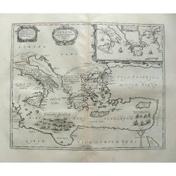
Attica Megarica.
From the Hornius edition of the Ancient Atlas with Janssonius. No text on verso.Fine copperplate engraving of Attica and the surrounding regions with the cities of Athens...
Date: Amsterdam, ca 1690
Selling price: ????
Please login to see price!
Sold in 2010
Aeneae Troiani navigatio.
From the Hornius edition of the Ancient Atlas by Janssonius. No text on verso
Date: Amsterdam ca 1690
Selling price: ????
Please login to see price!
Sold in 2010
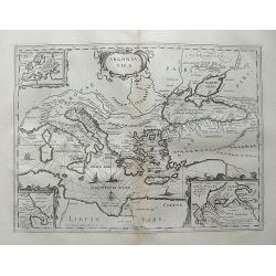
Argonautica.
Petrus Kaerius coelavit
Date: Amsterdam, ca 1690
Selling price: ????
Please login to see price!
Sold in 2012
Imperium Romanum. Auth. Phil. Briet e Societ Iesu.
From the Hornius edition of the Ancient Atlas by Janssonius. No text on verso
Date: Amsterdam, ca 1690
Selling price: ????
Please login to see price!
Sold in 2010
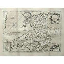
Cambriae typus, Auctore Humfredo Lhuydo.
From the Hornius edition of the Ancient Atlas by Janssonius. No text on verso.Engraved by Petrus Kaerius.
Date: Amsterdam, ca 1690
Selling price: ????
Please login to see price!
Sold in 2013
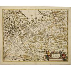
Tabula Russia Vulgo Moscovia.
A detailed map including all western Russia and most of Finland. With very decorative title cartouche.
Date: Amsterdam, 1690
Selling price: ????
Please login to see price!
Sold in 2010
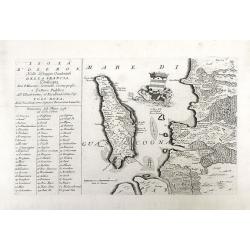
Isola D'oleron Nelle Piaggie Occidentali della Francia, Dedicata Dal P. Maestro Coronelli, coscmografo et Lettore Publico all Illustrisimo, et Eccellentissimo Sig. Polo Dona...
A beautiful map showing the isle of Oleron, located in the Bay of Biscay off the coast of France, from Vincenzo Coronelli's Corso Geografico Universale. A numbered key of...
Date: Venice, 1690
Selling price: ????
Please login to see price!
Sold in 2010
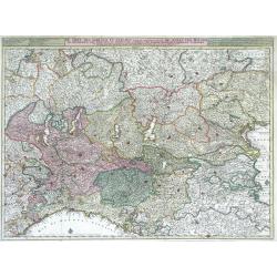
De Sotel Des Oorlogs in Italien, Waar in Vertoont Werden De Staat Van Milano, De Republicen Van Venetien en Genoua, De Landen Van Parma, Mantoua, Modena, Ferrara ...
Large, highly detailed map of the Duchy (state) of Milan, the republics of Venice and Genoa, and the regions of Parma, Mantua, Modena and Ferrara of northern Italy by Nic...
Date: Amsterdam, c. 1690
Selling price: ????
Please login to see price!
Sold in 2010
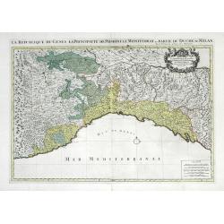
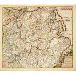
La Republique de Genes la Principaute de Piemont le Montferrat, et Partie du Duche de Milan.
Large scale map showing the Republic of Genoa, the Principalities of Piedmont, the duchy of Montserrate and southernwestern region of the Duchy of Milan in Northern Italy...
Date: Paris, 1690
Selling price: ????
Please login to see price!
Sold in 2010
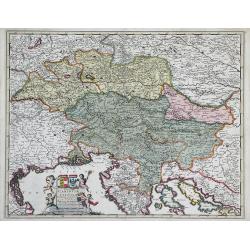
Ducatus Carintiae et Carniolae Cilleiae Comitatus. . .
Map of Italy including the duchies of Carinthia, Carniola and Cilleia once part of the Holy Roman Empire. Regions surrounding these duchies are also shown including Styri...
Date: Amsterdam, c. 1690
Selling price: ????
Please login to see price!
Sold in 2010
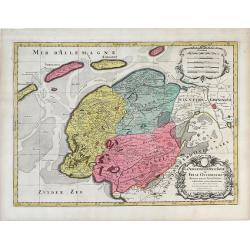
La Seigneurie d'Ovest-Frise ou Frise Occidentale, divisee en ses Trois Parties subdivisees en leurs Juridictions. . .
Map of Friesland, a province in the northern Netherlands by Sanson and published by Covens and Mortier. The three colored regions or shires are Seven Wolden (Seven Forest...
Date: Amsterdam, c. 1690
Selling price: ????
Please login to see price!
Sold in 2010
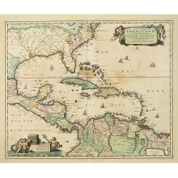
Insulae Americanae in Oceano Septentrionali. . .
A particularly handsome map portraying the south-eastern U.S., the Caribbean islands, part of Mexico, Central America, Florida (called tegesta Prov. ) and part of South A...
Date: Amsterdam, 1690
Selling price: ????
Please login to see price!
Sold in 2019
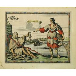
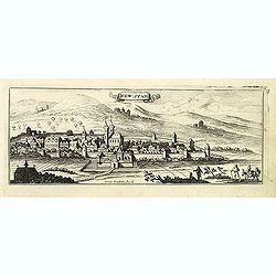
Nieu Amsterdam al. New York.
Engraved by Aldert Meyer for Carolus Allard's for his Orbis habitabilis oppida et vestitus the print shows two locals and a distance view of lower Manhattan. This rare wo...
Date: Amsterdam, c.1685-1690
Selling price: ????
Please login to see price!
Sold in 2010
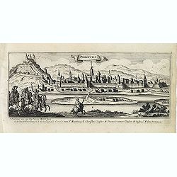
New : Stadt. [Wiener Neustadt)
Magnificent bird's eye- of Wiener Neustadt. Etched by Gaspar Bouttats (1640-1695).The Antwerp based publisher Jacques Peeters published ca. 1690 a series of prints relate...
Date: Antwerp, c.1690
Selling price: ????
Please login to see price!
Sold in 2014
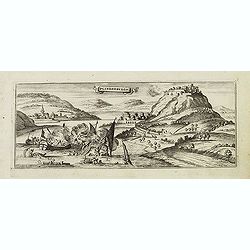
Presburg. (Bratislava)
Magnificent bird's eye- of Bratislava. Etched by Gaspar Bouttats (1640-1695).The Antwerp based publisher Jacques Peeters published ca. 1690 a series of prints related to ...
Date: Antwerp, c.1690
Selling price: ????
Please login to see price!
Sold in 2011
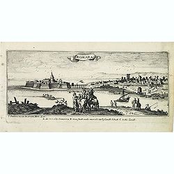
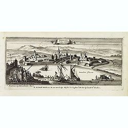
Komara. (Komarno)
Magnificent bird's eye- of Komarno in Slovakia, with Danube in foreground. Etched by Gaspar Bouttats (1640-1695).The Antwerp based publisher Jacques Peeters published ca....
Date: Antwerp, c.1690
Selling price: ????
Please login to see price!
Sold in 2011
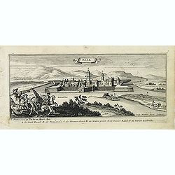
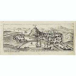
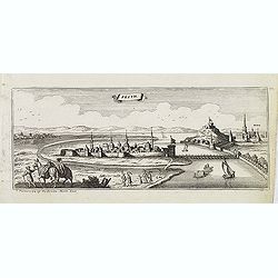
Raab. (Györ)
Magnificent bird's eye- of Györ with river Danube in foreground. Etched by Gaspar Bouttats (1640-1695).The Antwerp based publisher Jacques Peeters published ca. 1690 a s...
Date: Antwerp, c.1690
Selling price: ????
Please login to see price!
Sold in 2011
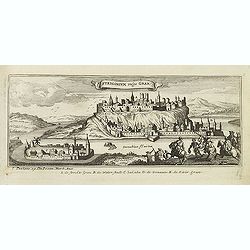
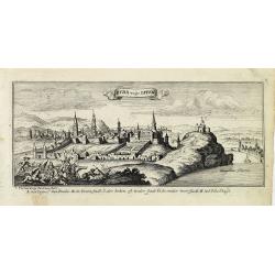
Strigonium vulgo Gran. (Esztergom)
Magnificent bird's eye- of Esztergom, with the river Danube in the foreground. Etched by Gaspar Bouttats (1640-1695).The Antwerp based publisher Jacques Peeters published...
Date: Antwerp, c.1690
Selling price: ????
Please login to see price!
Sold in 2011
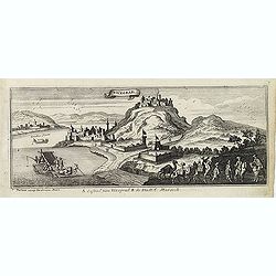
Vicegrad. (Visegrad)
Magnificent bird's eye- of Visegrad with the river Danube in the foreground. Etched by Gaspar Bouttats (1640-1695).The Antwerp based publisher Jacques Peeters published c...
Date: Antwerp, c.1690
Selling price: ????
Please login to see price!
Sold in 2011
Plinderburgh. (Visegrad)
Magnificent bird's eye- of Visegrad. Etched by Gaspar Bouttats (1640-1695).The Antwerp based publisher Jacques Peeters published ca. 1690 a series of prints related to th...
Date: Antwerp, c.1690
Selling price: ????
Please login to see price!
Sold in 2011
Waitzen vulgo. Vacia. (Vac)
Magnificent bird's eye- of Vac with the river Danube in the foreground. Etched by Gaspar Bouttats (1640-1695).The Antwerp based publisher Jacques Peeters published ca. 16...
Date: Antwerp, c.1690
Selling price: ????
Please login to see price!
Sold in 2011
Buda. ( Budapest. )
Magnificent bird's eye- of Budapest. View of Buda from the north. Etched by Gaspar Bouttats (1640-1695).The Antwerp based publisher Jacques Peeters published ca. 1690 a s...
Date: Antwerp, c.1690
Selling price: ????
Please login to see price!
Sold in 2011
Buda vulgo offen.
Magnificent bird's eye- of Budapest with battle scenes in the foreground. Etched by Gaspar Bouttats (1640-1695).The Antwerp based publisher Jacques Peeters published ca. ...
Date: Antwerp, c.1690
Selling price: ????
Please login to see price!
Sold in 2011
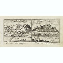
Castel van Presburg / Castel van Buda.
Magnificent bird's eye- of Bratislava and the castle of Budapest. Etched by Gaspar Bouttats (1640-1695).The Antwerp based publisher Jacques Peeters published ca. 1690 a s...
Date: Antwerp, c.1690
Selling price: ????
Please login to see price!
Sold in 2013
Pesth. ( Budapest.)
Magnificent bird's eye- of Budapest. Etched by Gaspar Bouttats (1640-1695).The Antwerp based publisher Jacques Peeters published ca. 1690 a series of prints related to th...
Date: Antwerp, c.1690
Selling price: ????
Please login to see price!
Sold in 2016