Browse Listings
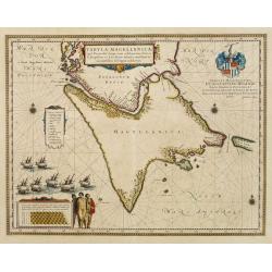
Tabula Magellanica.
A map with Willem Blaeu\'s signature, but published by his son Joan, of South America\'s extremity. A dedication to Constantijn Huygens.
Date: Amsterdam, 1660
Selling price: ????
Please login to see price!
Sold in 2009
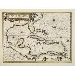
Insulae Americanae in oceano septentrionali..
Finely engraved map, showing the Gulf of Mexico and the West Indian Islands, and the adjacent North and South American coastlines.The cartography is based on the rare Ger...
Date: Amsterdam, 1660
Selling price: ????
Please login to see price!
Sold in 2008
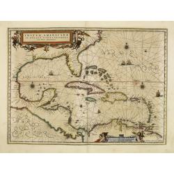
Insulae Americanae in oceano septentrionali..
Finely engraved map, showing the Gulf of Mexico and the West Indian Islands, and the adjacent North and South American coastlines.The cartography is based on the rare Ger...
Date: Amsterdam, 1660
Selling price: ????
Please login to see price!
Sold in 2011
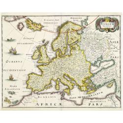
EUROPA Nova delineatio.
Decorative map of Europe, after Blaeu, depicting the mythical island of Friesland.
Date: Frankfurt, 1660
Selling price: ????
Please login to see price!
Sold in 2011
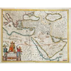
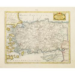
Turcicum imperium.
A Blaeu map with a fine cartouche showing the Turkish Sultan on his throne and allegorical figures. Sailing ships in the Arabian Sea and the Mediterranean. With many pla...
Date: Amsterdam, 1660
Selling price: ????
Please login to see price!
Sold in 2013
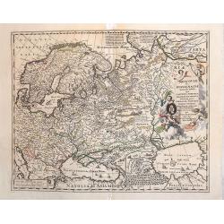
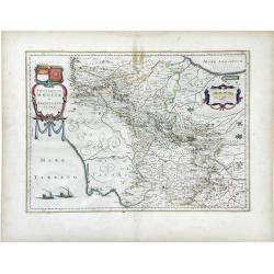
Moscoviae seu Russiae Magnae.
Map showing Russia, eastern Europe including Scandinavia.
Date: Amsterdam, c. 1660
Selling price: ????
Please login to see price!
Sold in 2013
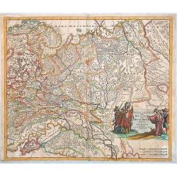
Novissima et Accuratissima Totius Russiae vulgo Moscoviae tabula a Justo Danckerts, Amstelodami
It covers the entire Russia of early 1600s, from Novaya Zemlya to northern shores of the Black Sea and the Caspian Sea and from the Chernigov lands to the Urals. With th...
Date: Amsterdam, 1660
Selling price: ????
Please login to see price!
Sold in 2013
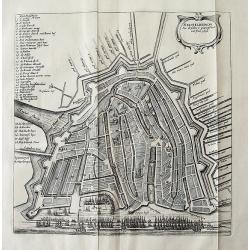
![[Waterland, Purmer, and Bijlmer] Kaarte vande Buycker-slooter, Broecker ende Belmer Meeren in Water-land Gemeten door Mr. SN Boonacker. . .](/uploads/cache/11504-250x250.jpg)
[Waterland, Purmer, and Bijlmer] Kaarte vande Buycker-slooter, Broecker ende Belmer Meeren in Water-land Gemeten door Mr. SN Boonacker. . .
Five maps on one sheet. Showing the polders of De Zype, De Purmer, De Wormer, De Beemster and a map of Waterland, including de Bylmermeer and Monnekedam. Showing the Noor...
Date: Amsterdam, 1660
Selling price: ????
Please login to see price!
Sold in 2019
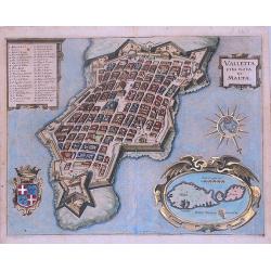
Valletta citta nova di Malta.
Exceptional, early view of Valletta and Malta.
Date: Frankfurt, 1660
Selling price: ????
Please login to see price!
Sold in 2013
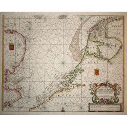
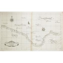
Pas Caert van Texel tot aen de Hoofden.
Very scarce and handsome sea chart of the coast of Friesland to France and at the other side of the Channel, England. It is richly embellished with rhumb lines, a half co...
Date: Amsterdam, 1660
Selling price: ????
Please login to see price!
Sold in 2008
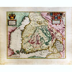
Magnus Ducatus Finlandiae Auct. Andrea Bureo Succo.
The first printed survey map of Finland, composed by the Swedish cartographer Anders Bureus (1571-1661). The map was published in 1662 in the second volume of Joan Blaeus...
Date: Amsterdam, 1660
Selling price: ????
Please login to see price!
Sold in 2015
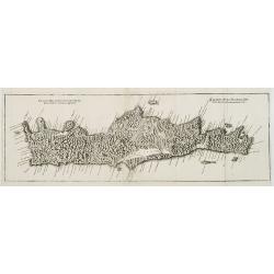
Genuina delineatio insulae Cretae..
A beautifully engraved map of Crete.
Date: Frankfurt, 1660
Selling price: ????
Please login to see price!
Sold in 2008
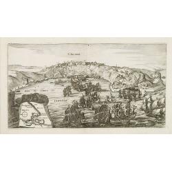
S. SALVADOR.
Charming view of Salvador de Bahia, in Brazil, seen from the ocean. In lower left inset map of Baia de todos os Sanctos.
Date: Frankfurt, 1660
Selling price: ????
Please login to see price!
Sold in 2008
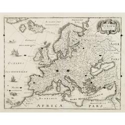
EUROPA Nova delineatio.
Decorative map of Europe, after Blaeu, depicting the mythical island of Friesland.
Date: Frankfurt, 1660
Selling price: ????
Please login to see price!
Sold in 2008
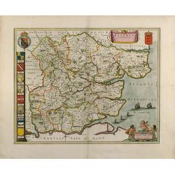
Essexia Comitatus
Outstanding attractive map of the country of Essex in UK. Showing London in the lower left corner. color is gold heightened, with king coats of arms and family coats of a...
Date: 1660
Selling price: ????
Please login to see price!
Sold in 2008
Insula Borneo et Occidentalis Pars Celebis cum Adjacentibus Insulis
Reissue of Jansson map.
Date: Amsterdam, c.1660
Selling price: ????
Please login to see price!
Sold in 2009
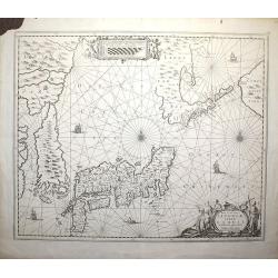
Nova et Accurata Japoniae, Terrae Esonis, ac Insularum Adjacentium ex Novissima Detectione Descriptio. Apud Ioannem Ianssonium
This edition is without text on the back.
Date: Amsterdam, c. 1660
Selling price: ????
Please login to see price!
Sold in 2008
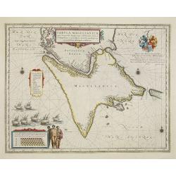
Tabula Magellanica.
A map with Willem Blaeu's signature, but published by his son Joan, of South America's extremity. A dedication to Constantijn Huygens.
Date: Amsterdam, 1660
Selling price: ????
Please login to see price!
Sold in 2017
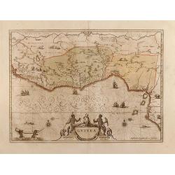
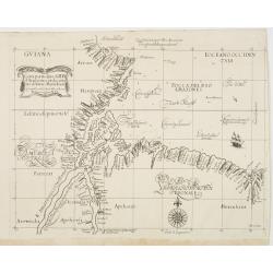
Guinea
Very attractive map of Guinea and Benin. Various animals and ships are shown.Dutch text on verso.
Date: Amsterdam, 1660
Selling price: ????
Please login to see price!
Sold in 2013
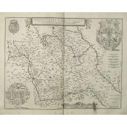
Galloflandria, in qua Castellaniae Lilana, Duacena, & Orchiesia, cum dependentibus, necnon Tornacum, & Tornacesium. Auctore Martino Doue Gallo-Flandro.
Map of French Flanders. Blank on verso. A finely engraved map from the most important Dutch map publishers of the 17th century. The plate was acquired by the Blaeu's from...
Date: Amsterdam, 1660
Selling price: ????
Please login to see price!
Sold in 2019
Flandriae Partes duae quarum altera proprietaria . . .
No text on verso.! A very detailed map with Gent in the center. Lower right corner Antwerp and Vlissingen in top right. At bottom left a very decorative cartouche with a ...
Date: Amsterdam, ca. 1660
Selling price: ????
Please login to see price!
Sold in 2009
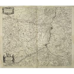
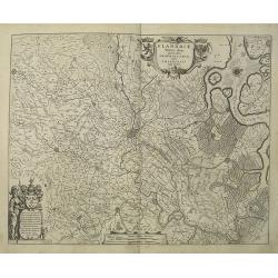
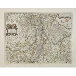
Dioecesis Leodiensis Accurata Tabula.
Detailed map of Belgium taken from H. Hondius map and updated. Shows the river Maas, part of Belgium next to Brabant. Including the towns of Liege, Maastricht, Namur and ...
Date: Amsterdam, ca.1660
Selling price: ????
Please login to see price!
Sold in 2009
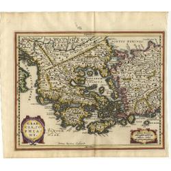
Attica Megarici, Corinthiaca, Boeotia, Phocis Locri.
Fine copperplate engraving of Attica and the surrounding regions with the cities of Athens, Thebes, Opus, and Corinth accentuated. The map is graphically engraved to illu...
Date: Amsterdam 1660
Selling price: ????
Please login to see price!
Sold in 2009
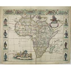
Nova Africa descriptio.
A beautifully engraved and most attractive 'carte a figures' of the African continent. Bordered, above, by panels showing panorama's of Cairo, Alexandria, Algiers, Tunis,...
Date: Amsterdam, 1660
Selling price: ????
Please login to see price!
Sold in 2009
Fretum Nassovium vulgo de Straet Nassou.
Decorative map of the Nassau Strait, from the Atlas Major. Includes 2 compass roses, sailing ships, rhumb lines and 2 elaborate cartouches. Latin text below and on verso.
Date: Amsterdam, 1660
Selling price: ????
Please login to see price!
Sold in 2009
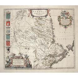
Sueonia Proprie fie dicta.
A very decorative map of eastern Sweden. Several beautiful cartouche are displayed. The left side is adorned with municipal code of arms.
Date: Amsterdam, 1660
Selling price: ????
Please login to see price!
Sold in 2009
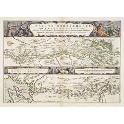
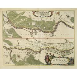
Tractus Borysthenis vulgo Dniepr et Niepr Dicti, A Civitate Czyrkassii as ostia et Ilmien lacum, per quem in Pontum Euxinium se exonerat . . .
This superb map shows the upper part of the Dnieper River in two horizontal strips, the upper map with a compass rose orienting the map, west to the top. It is richly emb...
Date: Amsterdam, 1660
Selling price: ????
Please login to see price!
Sold in 2009
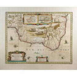
Accuratissima Brasiliae tabula.
A decorative map with a title cartouche of two natives, in the interior is an inset of Baya de Todos os Sanctos (Salvador), indigenous wild life and cannibal scenes.
Date: Amsterdam, 1660
Selling price: ????
Please login to see price!
Sold in 2009
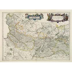
Nova Picardiae Tabula.
Detailed map of the northern part of France, including the area east of Calais till the Ardennes. Published in Joan Blaeu's "Atlas Maior".More about Joan Blaeu ...
Date: Amsterdam, 1660
Selling price: ????
Please login to see price!
Sold
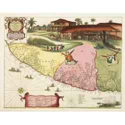
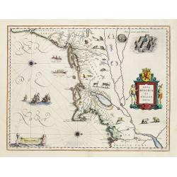
Praefecturae Paranambucae pars Borealis, una cum praefectura de Itamaraca.
This map is one the first maps of Brazil based on Dutch rather than Portuguese interest. The Dutch West India Company, appointed Count Johan Maurits Governor-General of D...
Date: Amsterdam, 1660
Selling price: ????
Please login to see price!
Sold in 2009
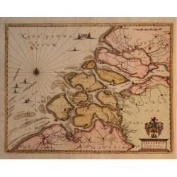
Zeelandia Comitatus.
Map of the Province of Zeeland, with its many islands and peninsulas. Major cities, small villages, and some of the natural features are named. Development over time has ...
Date: Francfurt, 1660
Selling price: ????
Please login to see price!
Sold in 2009
![[ Dedication addressed to Monseigneur Le Tellier ].](/uploads/cache/27758-250x250.jpg)
[ Dedication addressed to Monseigneur Le Tellier ].
Dedicational leaf from an atlas by N. Sanson to François Michel Le Tellier, (18 janvier 1641, Paris - 16 juillet 1691, Versailles). Le Tellier was a French statesman, an...
Date: Amsterdam, 1660
Selling price: ????
Please login to see price!
Sold in 2016
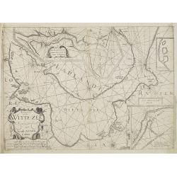
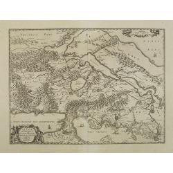
Pascaerte vande Witte-Zee. Nieulijkcx beschreve door Jacob Aertzen Colom.
Very rare chart wit insets of "De Riviere Dwina vande mont of tot de Stadt Archangel toe", and "Lombascho nae't leue ontworpen" and "Swetenoes, m...
Date: Amsterdam, 1660
Selling price: ????
Please login to see price!
Sold in 2010
Contado di Molise et Principato Ultra. . .
Map of southern Italy focusing on the county of Molise and the surrounding principalities of Ultra, Capitanata and Lavoro. Each was an administrative unit under the Kingd...
Date: Amsterdam, c. 1660
Selling price: ????
Please login to see price!
Sold in 2010
Tractus Borysthenis vulgo Dniepr et Niepr Dicti, à Kiovia ufque ad Bouzin.
This superb map shows the upper part of the Dnieper River in two horizontal strips, the upper map with a compass rose orienting the map, west to the top. It is richly emb...
Date: Amsterdam, 1660
Selling price: ????
Please login to see price!
Sold
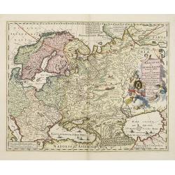
Moscoviae seu Russiae Magnae . . .
Map showing the eastern Europe and including Scandinavia.
Date: Amsterdam, c. 1660
Selling price: ????
Please login to see price!
Sold in 2011

Hollandia Comitatus.
Orientated west to the top of the sheet, this presents the County of Holland in the classical orientation for seventeenth-century maps, with Amsterdam at the center. The ...
Date: Amsterdam, 1660
Selling price: ????
Please login to see price!
Sold in 2024
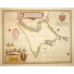
Tabula Magellanica.
A map with Willem Blaeu's signature, but published by his son Joan, of South America's extremity with the Strait of Magellan and Le Maire Strait.The coastlines are depict...
Date: Amsterdam, 1660
Selling price: ????
Please login to see price!
Sold in 2022
![[Title page] Topographia Galliae Dat is Eene Algemeene en bysondere naukeurige Land en Plaets beschrivinge, vant machtige Koninckrijck Vranckrijck. . .](/uploads/cache/31055-250x250.jpg)
[Title page] Topographia Galliae Dat is Eene Algemeene en bysondere naukeurige Land en Plaets beschrivinge, vant machtige Koninckrijck Vranckrijck. . .
Title page from a rare Dutch edition of Merian's description of France. Printed by the widow of Joost Broersz.The frontispiece features Neptune, a dolphin, medal, horn of...
Date: Amsterdam, 1660
Selling price: ????
Please login to see price!
Sold in 2016
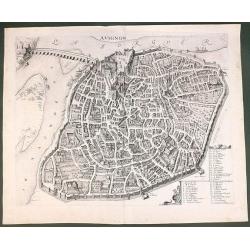
Avignon.
This rare bird's-eye plan depicts Avignon situated on both banks of the Sorgue River. A key locating 45 important sites is enclosed in the decorative cartouche at bottom ...
Date: Amsterdam, 1660
Selling price: ????
Please login to see price!
Sold in 2011
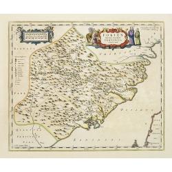
Fokien Imperii Sinarum Provincia undecima.
The province of Fokien lies opposite Taiwan and south of the region described in the above map. The coast is shown from Wen-zhou in the north to Fu-zhou and as far south ...
Date: Amsterdam, 1660
Selling price: ????
Please login to see price!
Sold in 2011
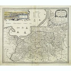
Tabula Prussiae eximia cura conscripta per Casparum Henneberch ..
Very fine and uncommon map of Prussia, prepared by Caspar Henneberger (1592-1600) in 1576. Engraved by Abraham Goos. In upper left corner inset view of Köningsberg (Kali...
Date: Amsterdam, 1660
Selling price: ????
Please login to see price!
Sold in 2013
![[First part of the Tabula Peutingeriana map with no tittle] Chrepstini Franci.](/uploads/cache/31368-250x250.jpg)
[First part of the Tabula Peutingeriana map with no tittle] Chrepstini Franci.
An uncommon variant of the first part of the Peutinger map, here showing a section of southeastern England with the roads and harbors marked.In the center France down to ...
Date: Amsterdam, 1660
Selling price: ????
Please login to see price!
Sold in 2011
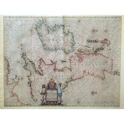
Pascaart vant Canaal, Tusschen Engelant en Vrancryck, alsmede ge heel Ierlant en Schotlant.
HEIGHTENED WITH GOLD LEAF. A beautifully colored chart of the coastal waters around the British Isles, northern France, and Ireland. With north oriented to the right, dec...
Date: Amsterdam, 1660
Selling price: ????
Please login to see price!
Sold in 2016
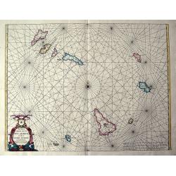
Pascaerte vande soute Eylanden oste Ilhas de Cabo Verde.
RARE sea chart of the Cape Verde Islands by Johannes van Loon. The islands shown with its towns and anchoring places. Island of Del Fuogo is shown with an erupting volcan...
Date: Amsterdam, c. 1660
Selling price: ????
Please login to see price!
Sold in 2020
AMSTELREDAM Soo deselue is geweest tot int Jaer 1612
Rare town plan of Amsterdam showing the city in 1612. Very detailed plan showing buildings, canals, streets, and numerous sailing ships in the port. Embellished wit...
Date: Amsterdam, c1660
Selling price: ????
Please login to see price!
Sold in 2011
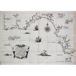
Carta particolare del'mare del Zur che comincia con il capo S. Francesco nel Peru e finisce con il capo S. Lazaro nella nuova Spagnia.
FIRST EDITION Dudley’s magnificent chart of the Pacific Coast of Central and South America, from the coast of Columbia and Ecuador in the north to the Bay of Honduras i...
Date: Florence 1661
Selling price: ????
Please login to see price!
Sold in 2023
Castellaniae Corturiacensis Tabula.
With a dedication by A.Sanderus to the nobles and the magistrates of the Castellany. Very detailed map including the towns of Menen, Tielt, Harelbeke, Cortryck and Deinze...
Date: Amsterdam, 1661
Selling price: ????
Please login to see price!
Sold in 2022
Nova Belgica et Anglia Nova.
Orientated with north to the right. This is one of the earliest maps to concentrate solely on this area of the colonies, excluding Virginia and the extreme north east coa...
Date: Amsterdam 1661
Selling price: ????
Please login to see price!
Sold
Geldria Ducatus et Zutphania Comitatus.
Map of Gelderland orientated west at the top, including Northern Limburg, eastern part of Brabant, Veluwe and Zutphen. Including the towns of Utrecht, Enschede, Rhunbeck,...
Date: Amsterdam, 1661
Selling price: ????
Please login to see price!
Sold in 2009
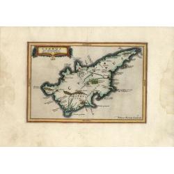
Cyprus Ex deliniatione Ubonis Emmii
A very scarce small map of Cyprus drawn by Ubonis Emmii and based on the Parergon map of Ortelius. Its shape is rather deformed and it has fewer ancient place names than ...
Date: Amsterdam, 1661
Selling price: ????
Please login to see price!
Sold in 2008
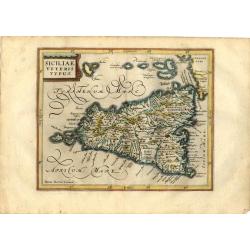
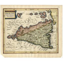
Siciliae Veteris Typus
Charming small map of ancient Sicily based largely on Ortelius and Gastaldi. Engraved by Petrus Kaerius and embellished with a strapwork title cartouche and decorative ca...
Date: Amsterdam, 1661
Selling price: ????
Please login to see price!
Sold in 2008
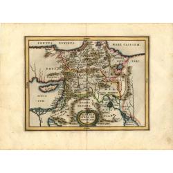
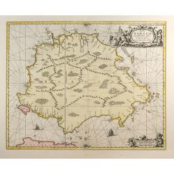
Armenia Syria, Mesopotamia etc.
This little map covers the region between the Black and Caspian Seas in the north, and from Egypt to the Persian Gulf in the south. It is finely engraved to show mountain...
Date: Amsterdam, 1661
Selling price: ????
Please login to see price!
Sold in 2008
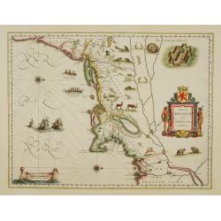
Nova Belgica et Anglia Nova.
Orientated with north to the right. This is one of the earliest maps to concentrate solely on this area of the colonies, excluding Virginia and the extreme north east coa...
Date: Amsterdam 1661
Selling price: ????
Please login to see price!
Sold
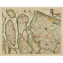
Delflandia, Schielandia.
Based ultimately on the large wall map by Balthazar Florisz van Berckenrode(1620-21), this finely engraved map shows the estuary of the River Maas and includes the area f...
Date: Amsterdam 1661
Selling price: ????
Please login to see price!
Sold
Carta Particolare dell? Rio d?Amazone con la costa sin al fiume Maranhan
Dudley?s magnificent map shows the mouth of the Amazon River. One of the smaller scale, more specific (?Carta Particolare?) maps and include sailing ships, notes on preva...
Date: Florence 1661
Selling price: ????
Please login to see price!
Sold
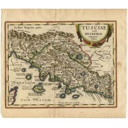
Tusciae sive Hetruriae Antiquae Typus.
A very attractive map of ancient Tuscany after Ortelius, whose map was based on Bellarmati's map supplemented by classical sources. Includes numerous small islands off th...
Date: Amsterdam 1661
Selling price: ????
Please login to see price!
Sold
Graecia, Sophiani.
Charming small map of ancient Greece based on the map by Nikolaus Sophianos. Embellished with two strapwork cartouches. Engraved by Petrus Kaerius.
Date: Amsterdam 1661
Selling price: ????
Please login to see price!
Sold
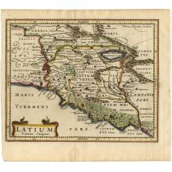
Latium Vestini, Campani
A fine small map of Italy's central-west coast, including Rome. Extends to include the Lago di Bracciano and down the coast to Gaeta. Good topographical detail, including...
Date: Amsterdam 1661
Selling price: ????
Please login to see price!
Sold
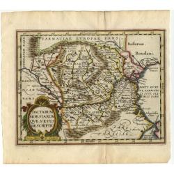
Daciarum Moesiarum que, Vetus Descriptio
Handsome small map of the ancient region of Romania and Bulgaria based on Ortelius' map of the same title. Filled with old place names and embellished with a fine title c...
Date: Amsterdam 1661
Selling price: ????
Please login to see price!
Sold
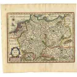
Germania.
Small map covering all of central Europe. The map is engraved with detail of rivers, mountains, and forests. Decorative title cartouche. At left of Holland a sailing ship...
Date: Amsterdam 1661
Selling price: ????
Please login to see price!
Sold

Belgii Veteris Typus Abrahami Ortelii.
Small map of this historic region with many ancient place names based on the map of Abraham Ortelius. The map is decorated with a delicate title cartouche.
Date: Amsterdam 1661
Selling price: ????
Please login to see price!
Sold
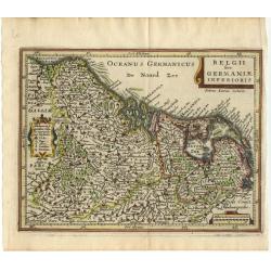
Belgii sive Germaniae Inferioris
Small map engraved by Petrus Kaerius, this map is filled with mountains, cities and villages. The map is oriented with north at right and is decorated with strapwork titl...
Date: Amsterdam 1661
Selling price: ????
Please login to see price!
Sold
![Benevole Lector, in hac tabula Urbis Moskuae.. [Moscow]](/uploads/cache/02033-250x250.jpg)
Benevole Lector, in hac tabula Urbis Moskuae.. [Moscow]
Rare from his atlas Major.An extremely fine plan of Moscow, which is likely to have been based upon the survey ordered by Boris Fyodorovich Godunov. With a 60-point key, ...
Date: Amsterdam 1661
Selling price: ????
Please login to see price!
Sold
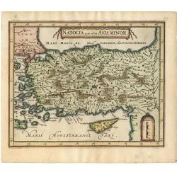
Natolia, Quae olim Asia Minor.
A small decorative map of Turkey and Cyprus with detail of mountains, rivers, lakes, cities and villages. Embellished with a banner style title cartouche and architectura...
Date: Amsterdam 1661
Selling price: ????
Please login to see price!
Sold
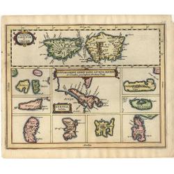
Insular Aliquot Aegaei Maris Antiqua Descrip.
A small map of Mediterranean islands based in part on Ortelius. The central map is of the Greek island Euboea and is surrounded by small maps of other islands. This compo...
Date: Amsterdam 1661
Selling price: ????
Please login to see price!
Sold
Siciliae veteris typus.
A small map of ancient Sicily based largely on Ortelius and Gastaldi. Engraved by Petrus Kaerius and embellished with a strapwork title cartouche.
Date: Amsterdam 1661
Selling price: ????
Please login to see price!
Sold
Una Carta del mare Oceano, che comincia con il capo S. Vinzensio in Portugallo, è Finisce con ll stretto de Gibilterra.
Robert Dudley (1574-1649). English geographer. Lived for the greater part in Florence in exile. His atlas 'Arcano del Mare' was the first English sea-atlas, the first sea...
Date: Florence, 1661
Selling price: ????
Please login to see price!
Sold
Nova Belgica et Anglia Nova.
Orientated with north to the right. This is one of the earliest maps to concentrate solely on this area of the colonies, excluding Virginia and the extreme north east coa...
Date: Amsterdam 1661
Selling price: ????
Please login to see price!
Sold
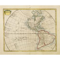
America.
Rare map of America, showing California as an island after the Briggs model. The continent is clearly after Visscher, c.1658 with the Blaeu type of depiction of the Great...
Date: Wolfenbüttel 1661
Selling price: ????
Please login to see price!
Sold
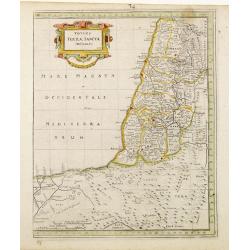
Totius Terrae Sanctae Delineatio.
Rare map of Palestine with large decorative title cartouche, from a book by Cluver Introductionis in Universam Geograpicam published by Johannis Bunonis.
Date: Wolfenbüttel 1661
Selling price: ????
Please login to see price!
Sold
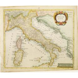
Italia Nova.
Rare map of Italy including only the north-eastern part of Sicily. Ornated with a large title cartouche.From a book by Cluver Introductionis in Universam Geograpicam publ...
Date: Wolfenbüttel 1661
Selling price: ????
Please login to see price!
Sold
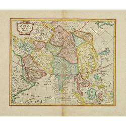
Asia Antiqua et Nova.
Rare map of Asia, from a book by Cluver Introductionis in Universam Geograpicam published by Johannis Bunonis.A first state.
Date: Wolfenbüttel 1661
Selling price: ????
Please login to see price!
Sold in 2014
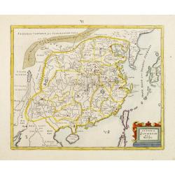
Imperii Sinarum Nova Descriptio.
Rare map of the easternmost part of China, from a book by Cluver Introductionis in Universam Geograpicam published by Johannis Bunonis.A first state.
Date: Wolfenbüttel 1661
Selling price: ????
Please login to see price!
Sold
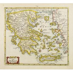
Hellas seu Graecia Universa.
Rare map of Greece, from a book by Cluver Introductionis in Universam Geograpicam published by Johannis Bunonis.A first state.
Date: Wolfenbüttel 1661
Selling price: ????
Please login to see price!
Sold
Chersonesi quae hodie Natolia Descriptio.
Rare map of Turkey, including Cyprus. From a book by Cluver Introductionis in Universam Geograpicam published by Johannis Bunonis.A first state.
Date: Wolfenbüttel 1661
Selling price: ????
Please login to see price!
Sold
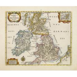
Veteris et Novae Britanniae Descriptio.
Rare map of the British Isles, with an inset map of the Orkney Islands in the upper right corner. Ornated with title cartouche, scale cartouche and compass rose.From a bo...
Date: Wolfenbüttel 1661
Selling price: ????
Please login to see price!
Sold
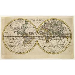
Typus Orbis Terrarum.
World map in double hemisphere showing the Arctic portion of North America as a geographical blank.In the Pacific discoveries are tentative, Australia is not outlined and...
Date: Wolfenbüttel 1661
Selling price: ????
Please login to see price!
Sold
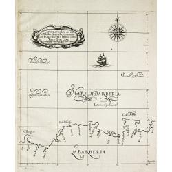
Carta particolare del mare Mediterraneo che comincia con il capo Bogia è Finisce con il porto de tre Croce.
Robert Dudley (1574-1649). English geographer. His rare atlas 'Arcano del Mare' was the first English sea-atlas, the first with charts -all in Mercator-projection- of the...
Date: Florence, 1661
Selling price: ????
Please login to see price!
Sold in 2009
Carta particolare del mare Mediterraneo che comincia con il capo Teti è Finisce con Folselli in Barberia.
Robert Dudley (1574-1649). English geographer. His rare atlas 'Arcano del Mare' was the first English sea-atlas, the first with charts -all in Mercator-projection- of the...
Date: Florence, 1661
Selling price: ????
Please login to see price!
Sold